Area Discussion Prior to Severe Wx Kickoff

Area discussion for the Dakotas: Lower heights area located over western S Dakota and stacks from 700-500mb and will make its way easterly throughout the day. 850mb winds from the south at 30Kts.

METSAT shows low/mid clouds moving into ND from the west with clearing over the center of the states where wx is expected. Upstream surface observations support this clearing as they show dry air advecting into the area from the south.

Radar shows weak convective activity to the north moving into Canada. Models and the SREF are in agreement that the majority of thunderstorm development happen around 1-3z.

Merged TPW Composite total PW values over the center of the N/S Dakota states where convection is expected according to SPC outlook is less than 1” with values between .80-.95” and AllSkyLAP 900mb PW is even lower at .30”.

NUCAPS fcst Sfc CAPE overlay CAPE values range between 400-500/kg but there are quite a few gaps in coverage.

Meanwhile AllskyLAP CAPE shows 900-1500J/kg, and NAM models show extremely high CAPE values of 3000-4500J/kg.

Local TAFs show no thunderstorms or even rain while the SPC continues to carry SLGT over the Dakotas. It’ll be interesting to see how this scenario plays out as the day progresses.

–DESMOND–

GLD AFD

Surface low moving into SW KS; progged to move over CWA through the afternoon and evening. Dew points currently in the 65-70F range in most of the CWA with temps of 75-80F. Cu field ongoing in NW CWA; sfc boundary bisecting from SW to NE both at surface and aloft.

Southwest flow at 500mb with weak shortwave troughs embedded in the flow. 12z DDC sounding has a large amount of CAPE above about 675mb (2700 J/kg) but has a large cap below. Convective temp is 95F.

HRRR shows 850mb winds rapidly increase this evening to 30kt by 00z in the eastern CWA; also indicates this is where convection would take place. NAM also shows this.

Based on surface obs and satellite trends, would expect the eastern CWA to indeed have the highest chance of convection.

Jason Williams & CoonieCatEye

Tags: None

AFD for KPDX

A well defined vort max on water vapor is moving into the KPDT CWA – very wound up. PWAT values of 1″ are showing up from the GOES sounder in the northeast CWA, which is the climatological max for June 1 at KBOI, the nearest sounding site (to the east).

Looking at RAP, CAPE gradient bisects the CWA at 20z. 0-6km shear is weak at 25 kts, suggesting organized convection will be multicell in nature. 0-1km shear is very low, basically negligible. Very large dry layer evident in the lowest 4000-5000 ft on the KBOI sounding. This suggests the main threats would be wind and possibly marginal hail (especially in the higher elevations) if any storms do turn severe. Really curious to see what the NUCAPS sounding looks like, especially in regards to the dry layer. We’ll have a forthcoming post regarding NUCAPS’ performance. We’ll have to see how the areas of clouds affect the data.

Given the strong shortwave, high PWATs, and weak flow, it appears heavy rain may be a threat from any convection that develops.

Eastern edge of the CWA is in an SPC MRGL outlook.

Jason Williams & MacGyver

Tags: None

14May2013 01Z Mesoscale Discussion Update

Best possibility for near-severe wind gusts and marginally severe hail appears to exist across the E half of Montana over next couple of hours. WRF simulated IR images and CIMSS 780-500mb difference products continue to point at this region having the best thermodynamic environment (approx 700-900 J/kg of CAPE) to maintain convective development during this time period. Regardless, severe threat still appears to be low-end.

0100zsimIR nrwcape_radar

Picca

Tags: None

2000z Mesoscale Discussion

Destabilization continues to occur further north into the southwestern portions of the OUN CWA. Surface CAPE values are approaching 3000 J/kg and CIN values are near zero. One severe storm has developed along the surface boundary and additional thunderstorms should develop.

In the SJT CWA, thunderstorms continue along the cold front/dryline. Thunderstorms should continue to build southward into the instability axis to the south. CAPE values remain in the 2500 to 3000 j/kg range with little CIN.

The severe storms in the southern FWD CWA continues to track ESE, but with no additional severe activity expected in the near-term, the FWD team has no moved into the OUN CWA where additional storms are expected and the pGLM data can be utilized.

Red outlines mark highest confidence for significant severe weather.

Hampshire

Tags: None

2011-06-09: Area Forecast Discussion

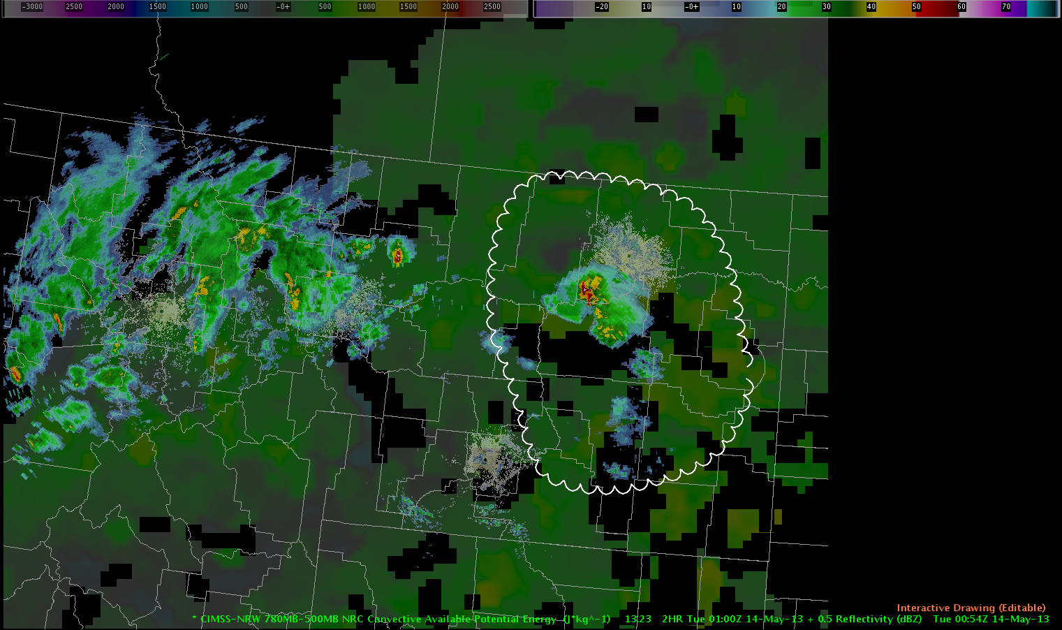
Cold front…analyzed at 17z from northern NY…to northwest Ohio will continue to move southeast through the afternoon hours. Convection is currently developing fairly across northwest VT to near Binghamton. Expect continued new convective development along the boundary towards the southwest…as forcing along the boundary quickly overwhelms limited CINH.

Observations of UAH CI products and CIMMS cloud top cooling products has confirmed the rapid nature of convective development.

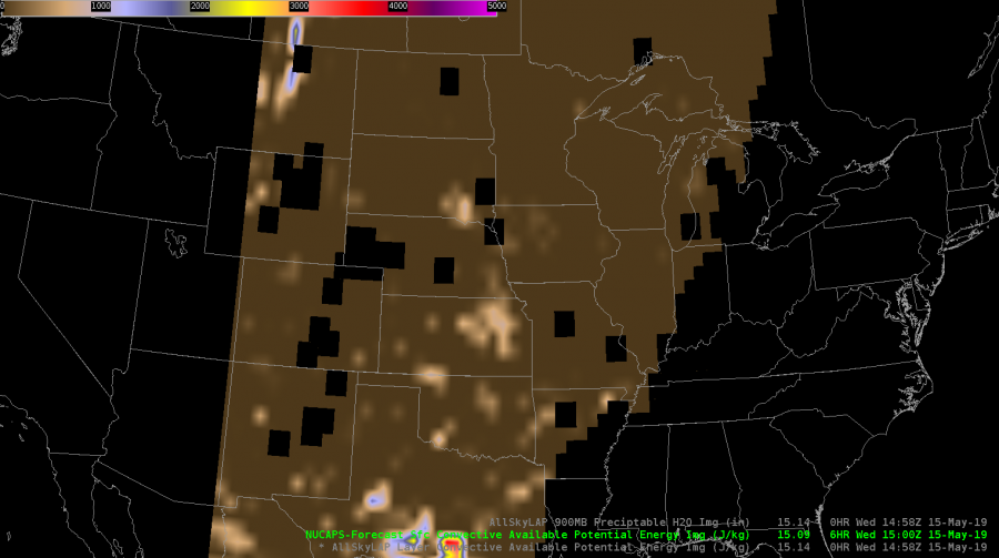
Objectively analyzed instability fields indicates moderate to extreme surface based energy exists ahead of the cold front…with an axis of 4000+ j/kg from just west of PHL to west of ALB. Forecast soundings ahead of the boundary suggest damaging wind gusts are the primary…and most widespread…severe weather threat.

Convection ahead of cold front is expected to exit New England by 2300z which may require shifting the area of interest farther to the west later in the operations period.

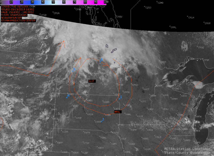
Frontal boundary becomes stationary…and more poorly defined westward across the western Ohio valley….to the central plains…as several areas of convectively induced outflow adds complexity to subjective analysis. Much of the area near the front/outflow boundaries through the Ohio valley will likely continue to be active with strong/severe storms through the afternoon and evening. A series of weak waves moving through the region may result in some modulation in the activity. Interest also points to portions of eastern KS… IA and northern half of MO… depending on exact location of boundaries and the front by late afternoon. Adequate deep layer shear would support a few supercells.

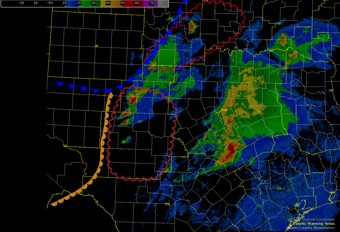
Farther southwest in OK…

The 15 UTC surface analysis shows a 1005 low south of Dodge City, KS,
and a frontal zone extending from near Kansas City to the low center
toward the SW into the Texas panhandle. A 30-35 kt Sly low level jet
is located over W Texas into W Kansas per RUC analysis. A zone of
elevated convection stretches from NE Kansas into N-central and SW
Oklahoma. East of the front, surface dew points are in the mid 60’s
over much of central and E OK, and the upper 50’s and low 60’s in W
Oklahoma. Within the warm air mass steep lapse rates are present in
the 800-500 hPa layer. A thermal axis at 850 hPa more or less
collocated with the zone of elevated convection is associated with a
rather robust cap that will probably require lift in addition to
diurnal heating in order to be broken.

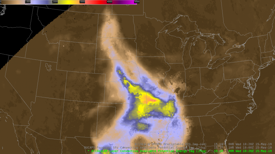
Model guidance suggests that CAPE should rise a little bit to ~2000
J/kg across most of C & E OK, E KS during the day, but there is
consensus among RUC/NAM and GFS that the boundary layer will tend to
dry out during the day, as a result of vertical mixing and northward
advection of drier air, analysed over north-central Texas. A shortwave
trough over E Colorado will move E/NE ward, but most forcing
associated with this feature should pass into Kansas.

GFS, RUC and NAM produce little to no precip over OK until 00 UTC
strong CAP. HRRR has a little bit of precipitation developing around
21 to 22 UTC in several runs.  Yet, a few storms will probably form
over W Oklahoma in vicinity of the front, probably in the late
afternoon or early evening (22-02 UTC). Somewhat higher coverage is
expected across Kansas. Given that 0-6 wind shear increases to about
40 kt, well-organized multicells and perhaps one or two rotating
storms will be possible. The few storms that develop will probably
produce some large hail, and, given the deep dry boundary layer, some
severe wind gusts.

Buonanno/Sohl/Groenemeijer

Tags: None

2011-06-08: Area Forecast Discussion Update

NW OK/SW KS

SOUTHERLY FLOW WILL CONTINUE TO ALLOW FOR MODEST IMPROVEMENT IN BL MOISTURE ACROSS THE SOUTHERN HIGH PLAINS THIS AFTERNOON…WITH SURFACE DEWPOINTS LIKELY REACHING THE LOWER 50S ACROSS THE REGION BY LATE IN THE DAY. THIS WILL COMBINE WITH VERY HOT TEMPERATURES…AROUND 100…TO RESULT IN MODERATE INSTABILITY. DESPITE VERY WARM H7 TEMPS…AROUND 15 C…FORECAST SOUNDINGS ARE LARGELY UNCAPPED AND FEATURE A CLASSIC INVERTED-V STRUCTURE. BL CONVERGENCE…ESPECIALLY IN THE VICINITY OF THE DRYLINE/SYNOPTIC FRONT INTERSECTION SHOULD BE SUFFICIENT TO ALLOW FOR ISOLATED/WIDELY SCT CONVECTION BY LATE AFTERNOON. VERTICAL SHEAR SHOULD REMAIN QUITE WEAK…GENERALLY PRECLUDING ORGANIZED STORM STRUCTURES. HOWEVER…IN LIGHT OF THE THERMODYNAMIC STRUCTURE…THERE SHOULD BE AN ENHANCED RISK OF HIGH-BASED CONVECTION PRODUCING OCCASIONAL HYBRID WET/DRY MICROBURSTS ACROSS THE REGION BY THE END OF THE DAY.

Tags: None

2011-06-08: Area Forecast Discussion

SYNOPSIS

THE LARGE SCALE PATTERN OVER THE CONUS CONTINUES TO BE CHARACTERIZED BY AN EASTERN RIDGE/WESTERN TROUGH…WITH A SURFACE QUASI-STATIONARY FRONT EXTENDING FROM THE NORTHERN GREAT LAKES INTO THE CENTRAL PLAINS. AS OF WEDNESDAY MORNING…A SW TROUGH WAS RAPIDLY SHEARING OUT OVER ONTARIO…AS IT ENCOUNTERED THE STRONGLY CONFLUENT FLOW OVER EASTERN NORTH AMERICA.

GREAT LAKES/UPPER MISS VALLEY

THE AFTERNOON CONVECTIVE FORECAST IS SOMEWHAT COMPLICATED BY THE PRESENCE OF ONGOING WARM SECTOR CONVECTION FROM EXTREME EASTERN IA INTO EASTERN WI AND MI. OVERALL…THIS ACTIVITY HAS BEEN GRADUALLY TRENDING DOWNWARD IN TERMS OF COVERAGE/INTENSITY DURING THE PAST TWO HOURS. MEANWHILE…THERE IS A NARROW CORRIDOR BETWEEN THE FRONT AND THE BACK EDGE OF THIS CONVECTION THAT IS DESTABILIZING QUITE NICELY FROM SOUTH CENTRAL IA INTO NORTHERN WI (MLCAPE VALUES WERE ALREADY IN THE 2500-3000 J/KG RANGE IN THIS AREA AS OF 1600 UTC). lOW LEVEL SOUTHWEST FLOW IN THIS REGION SHOULD MAINTAIN SURFACE DEWPOINTS IN THE MID/UPPER 60S…WHILE AFTERNOON TEMPS SHOULD SOAR WELL INTO THE 90S. A CONSENSUS OF MODEL GUIDANCE SUGGESTS MLCAPE SHOULD EASILY EXCEED 3500 J/KG JUST AHEAD OF THE FRONT BY LATE AFTERNOON. THIS REGION IS ALONG THE SOUTHERN EDGE OF THE WESTERLIES…SO SHEAR PARAMETERS RANGE FROM FAIRLY STRONG ACROSS NORTHERN WI…TO RELATIVELY WEAK ACROSS SOUTHERN IA. THIS IS UNLIKELY TO CHANGE SIGNIFICANTLY THROUGHOUT THE DAY.

AS THE FRONT SLOWLY SAGS SOUTHEAST ACROSS THE REGION… SCATTERED THUNDERSTORMS ARE EXPECTED TO DEVELOP THIS AFTERNOON. LACK OF SIGNIFICANT LARGE-SCALE FORCING SHOULD LIMIT THE OVERALL COVERAGE. HOWEVER…CLUSTERING OF CONVECTION ALONG COLD POOLS COULD OCCUR…PARTICULARLY IN THE MORE WEAKLY SHEARED AIRMASS ACROSS EASTERN IA. ACROSS WI…STORMS MAY TEND TO BE MORE DISCRETE/SUPERCELLULAR IN NATURE. HOWEVER…WITH THE VEERED LOW-LEVEL FLOW…THE THREAT OF TORNADOES SEEMS TO BE LOW…UNLESS WINDS BACK LOCALLY IN THE VCNY OF LINGERING OUTFLOW/DIFF HEATING BOUNDARIES. OTHERWISE…THE MAIN THREATS WILL BE IN THE FORM OF LARGE HAIL…SOME OF WHICH COLD BE VERY LARGE…AND DAMAGING DOWNBURSTS IN ASSOCIATION WITH THE MORE ACTIVE MULTICELLULAR COLD POOLS.

NORTHEAST/NRN NEW ENGLAND

ALTHOUGH THE AIRMASS OVER THE NORTHEAST WILL BECOME QUITE UNSTABLE THIS AFTERNOON…THE PRESENCE OF THE UPPER RIDGE OVER THE EASTERN CONUS SUGGESTS THE LARGE SCALE PATTERN IS GENERALLY UNFAVORABLE FOR SIGNIFICANT CONVECTIVE DEVELOPMENT. THE SURFACE FRONT WILL ALSO REMAIN TOO FAR TO THE WEST OF THE REGION TO PROVIDE A FOCUS FOR CONVECTION THIS AFTERNOON. ALTHOUGH DIFF HEATING SHOULD RESULT IN INITIATION ACROSS THE HIGHER TERRAIN OF NORTHERN NY/NORTHERN NE THIS AFTERNOON…IT APPEARS COVERAGE IS LIKELY TO BE TOO ISOLATED TO WARRANT EWP OPERATIONS IN THIS REGION. (A HIGHER THREAT MAY EXIST IN THIS AREA AFTER 00Z…ESPECIALLY IF CONVECTION ORGANIZES ALONG THE FRONT ACROSS SOUTHEAST ONTARIO/SRN QUEBEC THIS AFTERNOON).

CENTRAL HIGH PLAINS

VERTICAL WIND SHEAR WILL LIKELY BE SUPPORTIVE OF A ROTATING STORM OR TWO BY EARLY EVENING…IF SUFFICIENT DESTABILATION CAN OCCUR IN THE WAKE OF DEPARTING SURFACE RIDGE OVER CENTRAL AND NORTHERN PLAINS.  AT THIS TIME…RETURN FLOW OF INCREASINGLY MOIST UPSLOPE FLOW SUGGESTS ONLY MODEST DESTABILIZATION TODAY AND EXPECT VERY ISOLATED STORM COVERAGE THROUGH 03Z. THUS…BELIEVE EWP OPERATIONS SHOULD BE FOCUSED FARTHER EAST OVER GREAT LAKES/UPPER MISSISSIPPI VALLEY REGION.

Tags: None

Morning Area Forecast Discussion 6/7/2011

Satellite imagery reveals upper level energy…centered over southern Montana…with associated vort lobe extending through to northeast Colorado. Upper air analysis also indicates jet max from central Rockies region…then curves northward to the western Dakotas. Subjective surface analysis indicates a warm frontal boundary…from southeast North Dakota to northern Wisconsin.

Surface based instability…south of the warm front…has already 2000 + j/kg….immediately south of warm front. Short term model output suggests that instability will reach extreme levels across much of Minnesota and Wisconsin…and the extreme eastern Dakotas…as the warm front lifts slowly northward this afternoon. Forecast soundings indicate deep layer shear will continue to be strong…as jet energy remains near the area. Forecast low level shear fields appear to be strongest…>200 m2/s2 …from long Canadian border from eastern North Dakota…northern Minnesota…to Lake Superior.

Forecast convective initiation will be affected by a considerable low-mid level cap…per 12z regional soundings.

However…this convective inhibition is expected to weaken…as upper wave rotates through the northern plains this afternoon and evening.

At this time…expect greatest potential for severe convection will be across these areas (in order of greatest potential) :

  1. DLH
  2. GRB/MQT
  3. FGF
  4. northern areas of MPX/ARX

At this time…supercells appeared to be preferred between 21z-03z..across areas 1 and 2…across areas of best distribution of surface based instability and deep layer shear.

DC LMA —

Limited possibility exists for thunderstorms in the D.C. LMA… as an ongoing mcs complex over eastern Ohio and northern West Virginia may continue to track southeast towards the DC LMA target area and/or provide a low level focus for new development. Models indicate better instabilities will be located over the western part of the LMA. Marginal deep level shear will limit the likelihood for supercell development.

sohl/buonanno

Tags: None

Tornado Outbreak Likely over KS/OK/n TX

A tornado outbreak is likely across southcentral KS, Oklahoma, and north Texas.

At 17Z…Surface low was near Guymond with a stationary front extending east-northeastward across Kansas.  This boundary was reinforced by overnight convection which is still ongoing across northeast KS. However, the low-stratus was beginning to erode and allow daytime heating. Meanwhile, a dryline extended south from near Alva to Weatherford to Altus to Sweetwater.  Morning stratus ahead of the dryline was eroding as well with mostly clear right along the dryline. Developing cumulus already noted along the dryline across sw OK and western north TX which indicates SBCIN has already been removed.

Negative-tilt, diffluent, shortwave trough is poised to eject over tropical maritime airmass along and east of the dryline during the mid-afternoon to early evening hours, helping to erode any remaining CIN and rapidly increasing shear profiles. “Scickle-shaped” hodographs are forecast in the warm-sector by both NAM and RUC at 21Z, becoming even more pronounced by 00z and 03Z.  One minor point of concern is a bit of a loop in the mid-level (~3km) hodo and numerous storms forecast by OUN WRF and HRRR.

Recent OUN WRF runs develops CI between 18-19Z and from that point on it develops numerous storms along the dryline with updraft helicity (meso proxy) from sc KS to central OK to central TX.  Gabe says this model runs hot and early, so we shall see! NAM, RUC delay storms until 21Z. HRRR between 20-21Z.  Supercells should also fire along the W-E orentiented front over KS, but we are concenred they will become elevated hailers as they move northeast.

Pablo, Rudoph, and Bobby Prentice

Tags: None