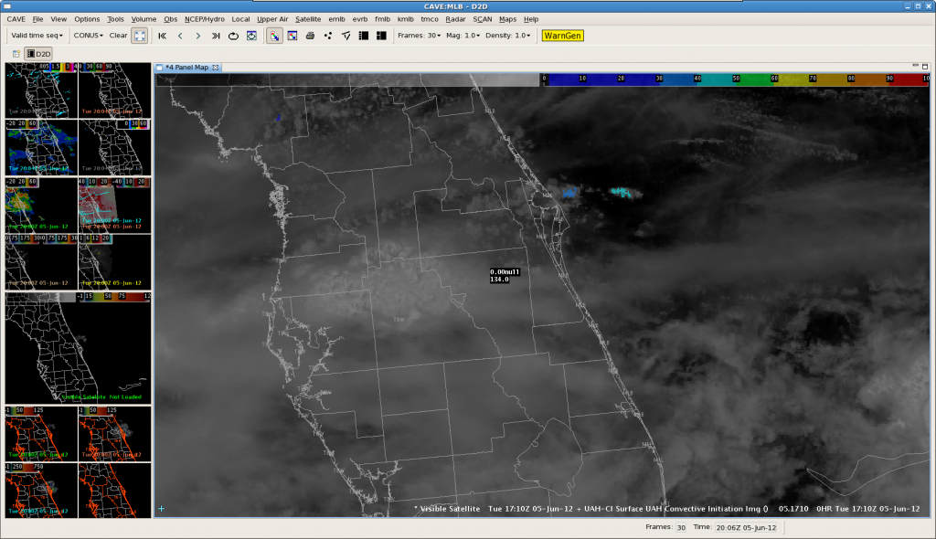
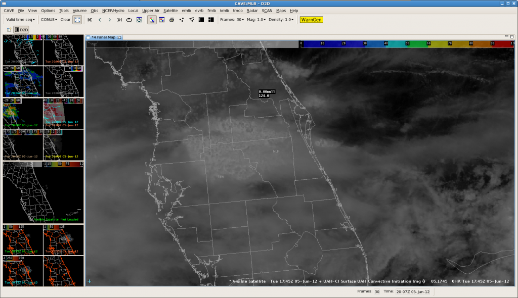
Looking across FL, much of the area was obscured by thick high clouds, making the CI products impossible to calculate/use. However, at 1710Z, the UAHCI algorithm did indicate possible CI just off the eastern FL coast, with a relatively low strength of signal of 30-40. Of note, the UWCTC algorithm did not hit on this cloud mass at all. As the follow image at 17:45Z shows, the band of clouds with a low SOS did not develop and actually diminished. This is within the expected outcome given the low SOS. -GS
Author: Kevin Manross
20110526 EWP Operational Morning Discussion
Previous forecast remains on track. We have decided to begin at Sterling so we can interrogate lighting products even thought we think this will be at the southern end of the best severe storm area.
Mostly sunny skies in combination with relatively steep mid-level lapse rates have led to extremely unstable air with CAPE values in the 3-4K range over VT-NY-ern PA-wrn MD-N VA area with CIN removed. A shortwave trough, perhaps convectively reinforced, was located over srn OH-ern KY moving east. Effective shear values are increasing rapidly.
CI has already occured over ern WV. We are in luck.
Convective initiation along sw OK dryline
Convective inititation occured along the southwest OK dryline. According to UAHCI and CIMMS CI products, had about 10-15 minute lead time for storm near Altus. 30 minute lead time from UAHCI and 20 mintue lead time from CIMMS CI for storm near Sayer.
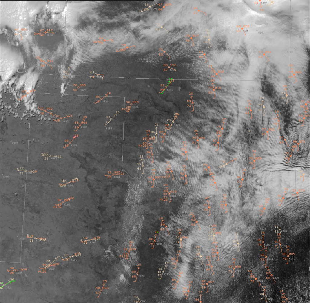
Horizontal convective rolls east of sw OK dryline suggest storms may form in the warm sector too…maybe!
Pablo, Rudoph, and Bobby
Tornado Outbreak Likely over KS/OK/n TX
A tornado outbreak is likely across southcentral KS, Oklahoma, and north Texas.
At 17Z…Surface low was near Guymond with a stationary front extending east-northeastward across Kansas. This boundary was reinforced by overnight convection which is still ongoing across northeast KS. However, the low-stratus was beginning to erode and allow daytime heating. Meanwhile, a dryline extended south from near Alva to Weatherford to Altus to Sweetwater. Morning stratus ahead of the dryline was eroding as well with mostly clear right along the dryline. Developing cumulus already noted along the dryline across sw OK and western north TX which indicates SBCIN has already been removed.
Negative-tilt, diffluent, shortwave trough is poised to eject over tropical maritime airmass along and east of the dryline during the mid-afternoon to early evening hours, helping to erode any remaining CIN and rapidly increasing shear profiles. “Scickle-shaped” hodographs are forecast in the warm-sector by both NAM and RUC at 21Z, becoming even more pronounced by 00z and 03Z. One minor point of concern is a bit of a loop in the mid-level (~3km) hodo and numerous storms forecast by OUN WRF and HRRR.
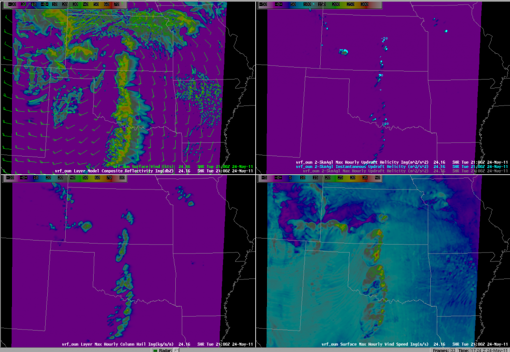
Recent OUN WRF runs develops CI between 18-19Z and from that point on it develops numerous storms along the dryline with updraft helicity (meso proxy) from sc KS to central OK to central TX. Gabe says this model runs hot and early, so we shall see! NAM, RUC delay storms until 21Z. HRRR between 20-21Z. Supercells should also fire along the W-E orentiented front over KS, but we are concenred they will become elevated hailers as they move northeast.
Pablo, Rudoph, and Bobby Prentice
Week 2 Summary (May 16-20 2011)
Week two allowed us to “spread our wings” a little, in that we operated in the DC domain some, and we made use of the 19 May 2010 Displaced Real Time case. Participants for this week were:
Kevin Brown (OUN), Kevin Donofrio (PQR), Bill Goodman (OKX), Steve Keighton (RNK), and Jessica Schultz (ROC)
We started off Monday as usual with training, however we opted to abbreviate the training and attempt to get our participants familiar with the data by having them jump into the DRT case Monday afternoon. This appeared to have some positive affects in getting the forecasters familiar with the set up as well as getting a first look at the data. Though I think we staved off the “death by powerpoint” issue somewhat, there still seemed to be less enthusiasm to this approach than I anticipated.
Another adjustment this week (compared to week 1) was to try and get the forecasters more involved with the EFP CI desk after getting their AFD completed for the EWP. We tried to have the EWP forecasters inteact with the EFP CI group by considering a “second CI target”. While this was a good idea, it is unclear quite how successfully the EWP personnel were in participating in the discussion and selection process.
On Tuesday, our AFD was initially focused on the central plains area, but shifted their guidance to the DEL-MAR-VA region. Warning operations started off in that area on marginally severe storms. With the remaining time, we switched to eastern CO to warn on tornadic supercells there.
Wednesday appeared to be a potentially active day for the OK domain if storms could fire. The OUN WRF painted a really interesting scenario with a supercell very near Oklahoma City. The DEL-MAR-VA area was again weakly severe, but we opted to use this day to monitor the CI products. After waiting most of the day, and after a visit by NWS OS&T director Don Berchoff, we returned operations to Eastern CO again.
For Thursday’s activities, we focused again on the OK domain – and this time we had convection! Storms fired early in SW OK. We sectorized on these storms immediately (forgoing the EFP CI collaboration). About a third of the way through the operations period, we shifted to the DDC/ICT/UEX domain as it appeared these storms would be more severe than the OK storms were at the time. Before long, we switched back to the OUN storms and that’s how we finished.
The following are some highlights from the weekly wrap-up discussion:
CI
Forecasters seemed to like the non-binary CI products. Though the UAH CI product was understood, users appreciated the level of uncertainty afforded by the CIMSS products.
UAH Sat Cast, looking for CI behind cirrus near dryline, never detected anything, which is good, no false alarms. Positive null detection
Ice masking to aid in sanity check was useful and appreciated.
NEARCAST products seemed not much different that looking at a RUC theta-E output for a few hours, but with advantage that it is based on observations and advected where you might not have the observations later.
pGLM
There was more discussion/comments on the pGLM product throughout the week than on the last day. Though the storms in the DEL-MAR-VA area weren’t terribly severe when we were observing them, the pGLM added some additional level of confidence in (non) severity.
The THU case was our best bet for looking at the pGLM, despite a LMA sensor/comms failure that adversely impacted the network for a period late in the operations period.
There was a request for to include what is known so far wrt to total lightning behavior. Participants requested more WES style cases. There was also a request for a CG/IC ratio product.
Lightning trend and jump information remains a hot topic, in that many are interested, but we want to make sure we don’t get the “cart before the horse” and verify any claims with solid research.
OUN WRF
On THU, in particular, OUN WRF gave good indication of storm morphology / mode. Was the only modle that depicted te storms in SW OK and maintaining them.
There was a recommendation for improved/new product combination available to the forecasters. The SimRef/Updraft Helicity/Vert. Int. Graupel is already being implemented after week 2.
Need to be wary about sharing outside the WFO (eg. EM community) for concerns of latching on to an incorrect solution. Sometimes it “almost looks too real”.
Time ensemble output/display is desired (something that Sterling does).
3DVAR
Suggestion to break up Updraft/Downdraft composites like the vorticity layer composites (0-3,3-7, total). Also consider Storm Relative Depth layers.
Request for a SRH product.
Placement of updraft seemed incorrect at times – especially with VA storms, but even with OK storms at times – even when compared to same-latency Sim Ref.
Think the 3DVAR products have a lot of potential to help with SA and add confidence, to help uncertainty with sampling at far ranges or over cone-of-silence. Swaths (trends) also very helpful.
2D wind vectors would be great to have in AWIPS if possible. Perhaps FSI, or using the “all-millibars” in the VB.
Logistics/Open Suggestions/MRMS
MRMS op system needs diagnostic tools, to show how many radars and elevation scans go into a grid point (or like CI ice-mask – not 100% optimal), and if it is less than 100% (radar outage), or radars running hot/cold. Need diagnostic tools to determine if system is not running optimally.
Feels like, “do what you want to”, “look at everything”, “falling into comfort zone”. Maybe the pairs of forecaster can do traditional warning, and other person looks at the experimental products. At least one person is focused on that particular product.
We again hear the suggestion of a multi-week setup. We are certainly not opposed to this, though NWS logistics would be a tough hurdle to overcome.
Hearing greater support (as well as from Week 3) for requiring future participants to complete training prior to arriving. (powerpoints, articulate, WES cases). This would help us gain “Monday” as an operational day.
Respectfully Submitted:
-kevin manross :: 2011 EWP Week 2 Weekly Coordinator
Week 2 :: Day 4
A good day for warning operations. Storms began initiating prior to the 1 pm discussion just south of Childress, TX. We jumped into warning operations immediately after our portion of the discussion.
At first, we had everyone issuing their own warnings at each workstation (minus the PAR corner which is being used to collect data). Unfortunately since we are all in the same CWA, everyone was seeing each others’ warnings. We then sectorized and had K Brown and Steve focusing on storms at I40 and North,
with Jessica, Bill and Kevin D focusing on the cells south of I40:
We will continue operations in OUN’s CWA, with an eye on Central KS for additional development of supercellular thunderstorms. If those develop, we will consider having a pair of forecasters move to that area.
-K Manross :: Week2 EWP Weekly Coordinator.
19 May 2011 morning discussion
Area of focus will be KS/OK, where dryline convection is forecast by all high-res models. There are timing differences between SPC WRF, HRRR, and OUN WRF…with OUN WRF and HRRR convecting earlier. Late morning OA indicating that cap has weakened to under 25 j/kg along and east of dryline so initiation before 20z possible near and south of Red River. Later initiation expected farther north across west-central and northwest OK, and with diurnal backing and low-level jet intensifcation, early this evening, intensification and tornado potential will increase by 23/00z.
Primary area of concern will be northwest Oklahoma into south-central Kansas (OUN-ICT CWAs) where tornadic potential will be higher and overall coverage expected to be greater. Although instability will be substantial farther south, better shear/LCL values will be seen farther north across nw OK into srn KS. This idea, with much greater updraft helicity forecasts, is supported by OUN WRF. Any convection in SW OK/NW TX is fcst to occur fairly early with weak cap…but not develop particularly strong or rotating updrafts. Concern that if a large area fires too early that may limit additional convectiv e development over nw OK or s-central KS due to cirrus debris. Still…low-level jet strengthening by evening may be enough to help support stronger convection in KS.
18Z position of dryline is just east of DDC to GAG/CDS/SNK. Little in the way of eastward mixing is expected today given deeper moisture to its east and strong jet/ht falls to its west. If storms can get going over west-central and northwest Oklahoma, they should have a better chance of survival off/east of dryline with much better flow over that region.
Despite some degree of uncertainty in timing and exact locations for supercell development in the srn Plains today…high res model guidance and lack of jet cirrus are giving us more confidence that deep convection will in fact develop in a few spots along dryline compared to yesterday…and thus it makes sense to stay focused on the OUN/DDC/ICT CWAs throughout the day…rather than spending any time at all evaluating products in the mid-Atlantic, where shallow convection under persistent upper low is expected to fire again with diurnal heating. In fact some very shallow convection already occuring and overall severe threat looks very minimal there.
A Visit By Don Berchoff
As we waited agonizingly for convection to initiate in our Central Oklahoma Domain (and as of this writing, we are still without storms), we were paid a visit by Don Berchoff, Director of the NWS OS&T.
Our discussion with Mr. Berchoff included:
- the need to continue improvements in Convective Initiation (both sensor and model based)
- using multi-sensor blending for more holistic storm interrogation
- his thoughts on the coming of AWIPS2 and the utility for extensibility
- the need for improved analysis and visualization tools in light of the 12 fold increase in data flow
“Fortunately” the weather “cooperated” with us and everyone in the room was able to engage in the discussion.
-K. Manross :: Week 2 EWP Weekly Coordinator
Week 2 :: Day 3
Oklahoma CI 18 May 2011
2330Z Update: UAH CI indicating possible development across Garvin and McClain counties. There does appear to be an HCR in this location but we believe that the edge of thin cirrus clouds are causing algorithm to detect cloud cooling that is not real. Looks like we are going to move operational area to eastern Colorado where there is a lone supercell. kbrown
2230Z Update: Got a hit off of the UAH CI over southern Comanche county where there are weak echoes aloft (15-20dbz). These echoes are associated with a wildfire plume, however.
2140Z: Brief UAH CI detected across north-central Oklahoma in cloud streets (1832Z), but no subsequent echoes were detected.
Although there has been several hours of cu/tcu formation near and east of dryline, CI algorithms have not detected CI across OUN domain. From 20Z to 2115Z this is actually a good thing since no echoes have developed (good case of low false alarm). Before the CIMSS CI became contaminated with Ice Cloud Mask, there were a few hits for CI on leading edge of incoming cirrus across northwest Oklahoma between 19Z to 20Z. No echoes were subsequently detected.
Isolated CI hits from the UAH algorithm did accurately depict some elevated echoes over the OK/AR border but no lightning occurred. Leadtime for echoes was 15 to 30 minutes. kbrown


