ProbTor reliable? Lightning says no, MRMS says maybe.

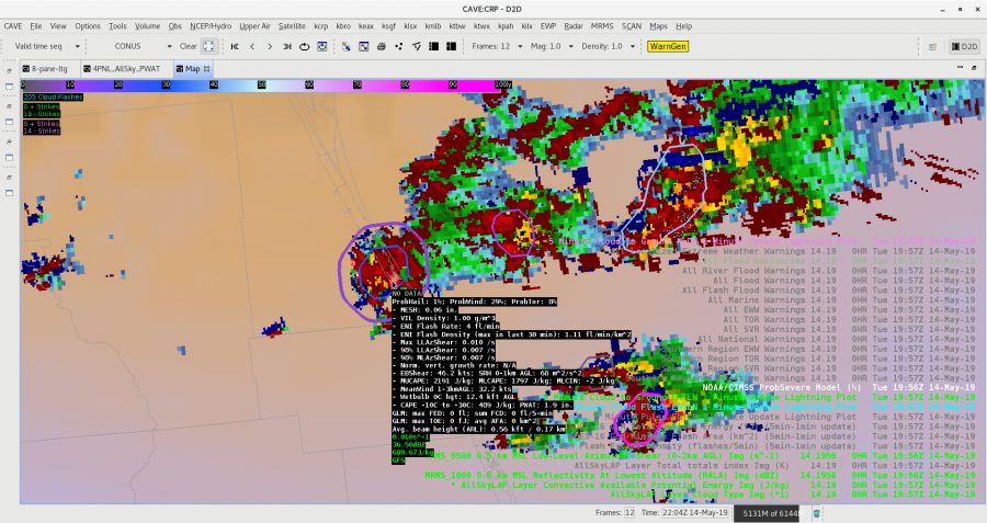
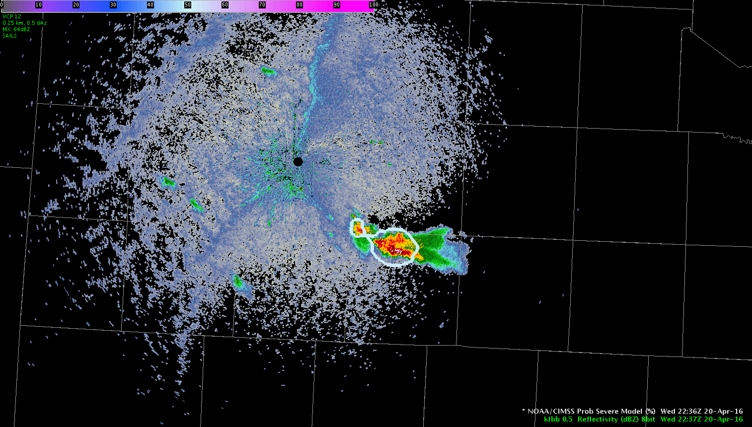
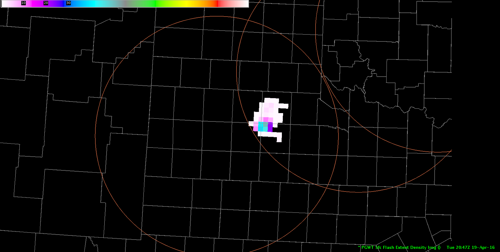
There is difficulty with having confidence of the ProbTor portion of the ProbSevere product due to an instance where it is estimating higher tor rates (8%) when a storm has no identified lightning (GLM, NLDN, and ENTI) along the coast of Florida. To be fair, the storm previously did indicate some lightning with it. I investigated the TOE, FED, and Min Flash Area in the vicinity of this storm, as well as usual point lightning data in 5 and 1 min updating intervals, and it has me confused as to what the ProbSevere is “seeing” for its lightning data (it is indicating ENTI lightning within its circle). Below is the image example of ProbSevere loaded alongside lightning data including GLM’s Min Flash Area:


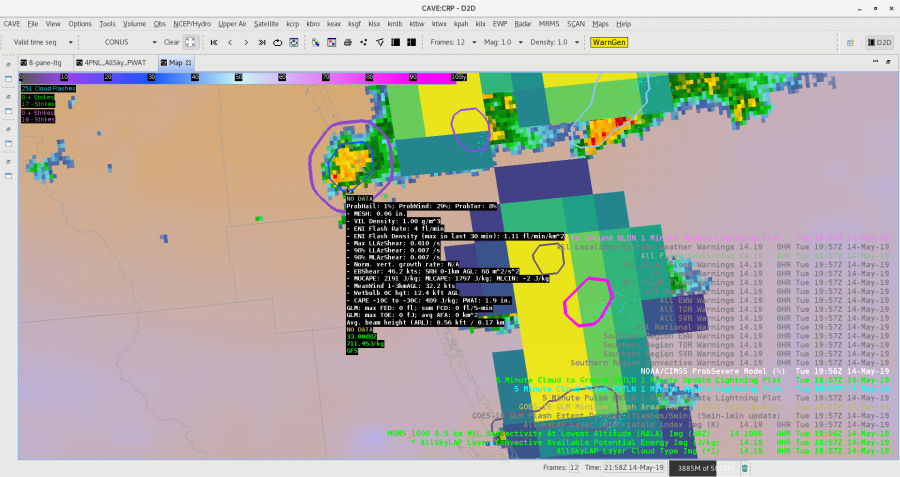
I also pulled up the lowest level rotation tracks from MRMS data, and it did indicate a slightly higher maximum within the ProbTor circle, so I believe the ProbTor is locking on to that feature.   – shearluck


This was interesting

Since things were kinda boring over HGX today I had to look for things to blog about. Here is something interesting that I noticed with the Vis/IR Sandwich RGB. At the beginning of the loop the RGB didn’t show any IR brightness temperatures. As the TCU continued to develop we saw pixels of IR brightness temperatures starting to show up indicating cold cloud tops and the potential for glaciation to start. Low and behold, if we continue to watch the loop, more pixels start showing up…and a few minutes later both GLM and ground based networks picked up on a couple of CGs. As the thunderstorm developed, cloud tops cooled and more pixels started getting displayed we began to see more lightning.  This was something that I didn’t expect the RGB to pick up on and potentially helpful for situational awareness and IDSS in the west where most lightning tends to come from single cell thunderstorms. If you are able to pick up on these ahead of time you may be able to some lead time before lightning occurs.

Update…it happened again, pixels starting being displayed and then lightning occurred within a couple of minutes. If this generally hold true for single cell thunderstorms this would be awesome for outdoor IDSS.

ProbSevere Split It

Quick update to a previous post. Like before, the first image shows GLM Event Density and the second shows base reflectivity with ProbSevere. It took ProbSevere’s tracking algorithm around 15-20 minutes to  splitting the storms into multiple ones. I would have been awesome if it happened earlier, but I’m not complaining. It happened quicker than I thought it would.

Will these storms split finally in ProbSevere?

Below are a few images for a long-lived storm in Pecos County that is starting to split. The first image shows GLM Event Density with two separate hot spots while the second image shows base reflectivity  with ProbSevere contours. It will be interesting to see if/when the ProbSevere tracking algorithm will splits the storm into two storms rather than one merged storm.

Storm Southeast of LBB’s RDA

Storm development has occurred southeast of the Lubbock, TX RDA in the Texas Panhandle.  While initially the all-tilts reflectivity looked promising, PROBSvr continued to indicate marginal severe potential.  Combine this with no significant lightning jump and low flash density on the PGLM array, the decision was made to hold off on a warning for now.LBBRadar


Tags: None

Mesoscale Analysis as of 1830z

J-Money Mesoscale Analysis as of 1830z:

Two regional short-wave features to note in the 700-500 mb layer this afternoon, as per water vapor imagery and meso-analysis data.  The leading system was near the TX/LA border and pushing east, with associated storms being heavy rain producers, given saturated, weakly sheared environment.  Houston LMA and flash rate density products show a fair amount of lightning as well.

Through 19-22z, better convective potential may shift to central/south TX, as a subtle 700 mb short-wave over west TX moves in.  This may interact with a decelerating outflow boundary in the vicinity.  Layered PW data depicts the leading edge of mid-level dry air and presumably steeper lapse rates as well.  Main question is can strong 700 mb cap shown on 12z KDRT sounding be overcome.  Time will tell.   Maybe 19z NUCAPS could help later today?

LayeredPW_CentralTX

1-minutevis_lightning


Tags: None

Mesoanalysis for Lake Charles Area

Latest IR loop shows a tendency for warming tops through mid morning in the MCS followed by a reinvioration of convection with cooling cloud tops evident over the past hour. This is occurring as the convective complex moves toward a low-level theta-e axis evident in RAP mesoanalysis and Layer PW extending from Southwest Louisiana north-northeastward into Central Louisiana. As diabatic heating continues over this area an increasingly unstable enviornment is developing with MLCAPE ~1,000 J/KG as of this writing. Convection has developed in this area east of the MCS this morning so far. The severe threat will be limited given loose storm organization at best due to weak deep layer shear. Isolated marginal damaging wind events may occur, but significant hail size will be difficult to acheive given tendency for short duration updrafts, limited CAPE in the hail growth zone, and limited complex storm interactions/mergers. For this experiment we will be particularly interested early on PGLM lightning data from Houston, CG lightning probability, and lightning jump since severe thunderstorms may be hard to come by. A move to another area is being discussed for later this afternoon once we examine lightning for a little while longer in Lake Charles’ area.

Houston PGLM (and range ring) overlaid on regional low-level reflectivity

-dryadiabat


Tags: None

Huge increase on PGLM prior to DRC?

Might have had a DRC from 2346z to 2354z on our middle cell. PGLM values of around 30-40 were present in the storm’s core at 2345z, jumping to 57 two minutes later, 70 at 2350z, and 99 a minute later. Possible hook echo showed up at 2359z and persisted through this post at 0007z.

Jason Williams

Tags: None

Value in GLM data

totallightningbigcrawler

The storm south of DIA has a very obvious core, but of note is how far away lightning is being observed from the parent updraft. NLDN shows a CG in the upper-right part of the lightning field, which is a very long distance from the main storm. In fact, there isn’t even any rain falling at that distance.

Jason Williams

Tags: None