Overview: Week 1, Day 2

10AM

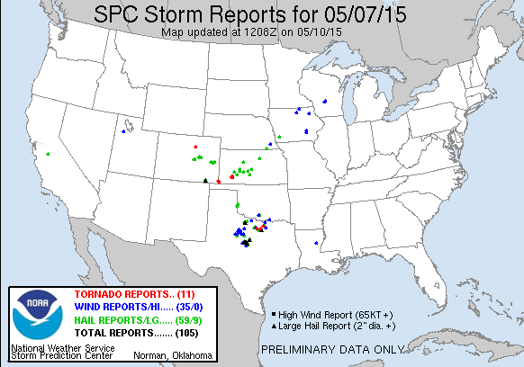
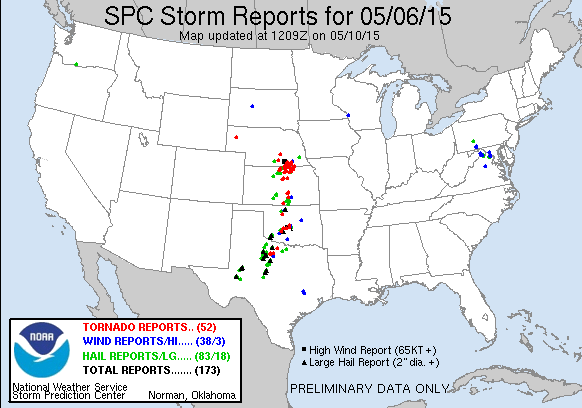
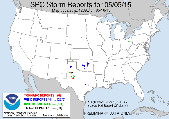
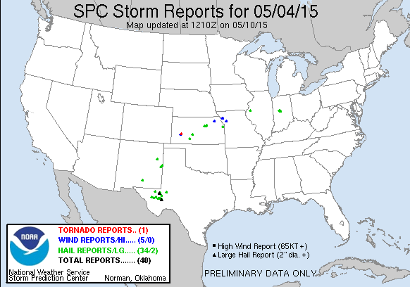
Day 2 of the experiment brought another Moderate Risk region from the SPC, driven by a 30% CIG 2 Hail outlook. Thunderstorms were expected to form along an advancing dry line, with a diffuse temperature and moisture gradient in place from southern Oklahoma to northern Alabama as of 15Z. After our morning debrief, the Fort Worth-Dallas office (FWD) was a pretty easy pick for us to target today. After more discussion, we decided our second WFO should be further east ahead of some early morning convection in the Jackson, MS (JAN) office. Unfortunately the Lightning Stoplight product continued to face ingest issues and was unavailable today, and we hope to have it in AWIPS tomorrow. In the meantime forecasters viewed that data on the SPoRT Lightning Viewer and in GR2Analyst.

1 PM

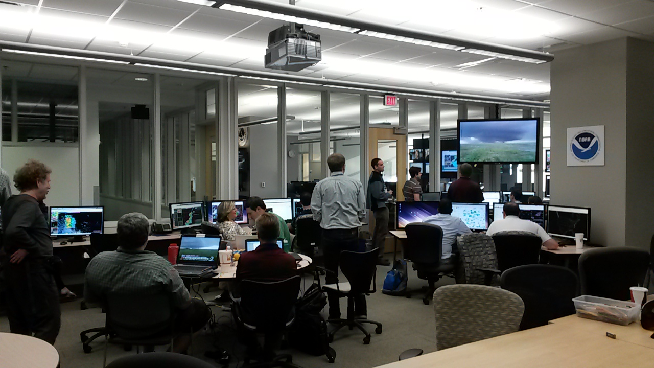
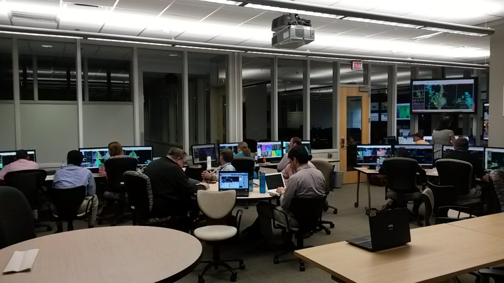
Forecasters today were tasked with issuing simulated Severe Thunderstorm and Tornado warnings in WarnGen on AWIPS-II, along with providing decision support for mock-events that we created for each office. Today FWD was tasked with mock-DSS for a Red River BBQ Cookoff near Gainesville, TX, and JAN was tasked with mock-DSS for a hazmat spill near Waverly, MS. Shortly after operations began, CI occurred just west of the FWD CWA, and thunderstorms were maturing just west of the JAN CWA. This gave everyone plenty of storms to observe, and the forecasters with the chance to issue warnings and communicate hazards through decision support.

I spent part of the day in ops viewing the SZA imagery product on the west coast shortly after sunrise. When comparing SZA data in a modified Day Cloud Phase Distinction RGB against the traditional RGB, the differences are stark right at sunrise, and features stand out sooner. How much sooner is something we need to determine. There was a nice discussion in the morning about how SZA imagery may benefit WFOs in higher latitudes (main example: Alaska). I also compared the modified SZA RGB against CIRA’s GeoColor imagery, and found that more interesting than anything.


When zooming into the SZA imagery in north Texas, it appears the 0.69µm (channel 2) imagery has ‘gaps’ in highly reflective features. My first hypothesis is that the solar zenith adjustment is pushing reflectance factor values above 130% and creating plotting issues in AWIPS, but I feel like traditional ABI visible imagery saw similar artifacts in AWIPS after launch that had to be corrected.

Kevin

Tags: None

Overview: Week 1, Day 1

9AM

Welcome to the testbed! Day 1 is usually when forecasters are just getting their feet wet with the products, but today they may get thrown into the deep end. The 13Z SPC Outlook features a Moderate Risk and large Enhanced-Slight Risk through the Mississippi Valley, driven by a 15% CIG2 threat. Forecasters will mostly be getting familiar with products and using AWIPS in cloud instances, but hopefully they will have plenty of good storms to observe today! Unfortunately we’re having issues getting the Lighting Stoplight tool into AWIPS, and it was only available online today.


1PM
We localized to Paducah, KY (PAH) and St. Louis, MO (LSX) with the expectation that semi-discrete thunderstorms would develop during our operations period. Unfortunately thunderstorms took too long to develop for PAH, but there was plenty of thunderstorms to the west across Missouri and north towards Illinois and Indiana.

We observed low level dry air from the Synthetic GXI data from a front and dry line that passed through western Oklahoma. It was interesting to compare the synthetic data from WVT and low(est) level water vapor at 5.15 µm against the observations from GOES-R in the split window difference and visible imagery at 0.64 µm. Some questions for the forecasters included how easy it was to identify features and boundaries in this clear-cut and more strongly forced scenario.

4PM

Later in the day our group also had a discussion about extremely large flashes as detected by GLM and the ground networks, and how (or if) they could be interpreted by products such as LightingCast or the Lighting Stoplight tool. Could LightningCast add lower probability contours? Would those contours add to noise and too many false alarms? How sensitive should users be to the appearance of probabilities?

6PM

To end the day, I saved off some animations of the SZA products. I tried adjust the Day Cloud Phase Distinction RGB recipe when including the Channel 2 and 5 SZA bands, so we will see how forecasters react to that product.
Kevin
Tags: None

Daily Summary: Week 4, Day 4

The final day of forecast activities for week 4 didn’t see much change geographically, with groups operating in the Boulder, Goodland, and Hastings CWA’s. The Goodland group would later move to Dodge City as activity to the south looked a little more promising. Once again, the Boulder group found the PGLM total lightning Flash Extent Density and Lightning Jump information to be quite valuable in monitoring fluctuations in storm/updraft intensity. One particularly strong storm near Simla, CO produced a tornado from which we were able to view live streaming footage (see image below). Activity in the other CWA’s, was a little slow to develop, giving participants ample time to evaluate the pre-convective products.

– Bill Line, SPC/HWT Satellite Liaison and Week 4 EWP Coordinator

20150604_190539


Tags: None

Daily Summary: Week 4, Day 3

Today’s activities took us to Cheyenne, Boulder, and Jacksonville, with the Cheyenne group moving to Topeka before ending in Dodge City. The PGLM total lightning Flash Extent Density within the Colorado LMA in NE Colorado saw heavy use with storms that developed in the Boulder CWA. It was nice to have a group operate in the Jacksonville today as it allows us to demonstrate the tools in a different region of the US. This is important considering most of the experiment has been spent west of the Mississippi River thus far. This group, however, did not have access to the 1-min imagery, something they missed dearly! The Boulder group found it helpful to monitor the LAP PWAT products as  moisture quickly approached the front range from the east, tightening the moisture gradient leading up to convective initiation. The approaching feature was also apparent in the 1-min imagery. The NUCAPS, CI, ProbSevere and ENI Lightning products all saw use throughout the day as well.

– Bill Line, SPC/HWT Satellite Liaison and Week 4 EWP Coordinator

Tags: None

Daily Summary: Week 4, Day 2

Today’s activities took us just a little further east into the Bismarck, Billings, and Cheyenne CWA’s. The Cheyenne group would later move to the Aberdeen CWA as activity shifted out of the CWA. Participants were able to analyze the LAP products and later the NUCAPS soundings to get an idea of where severe convection was most likely. The CI product was also monitored for initial development during this period. As convection grew and matured, participants utilized the ProbSevere Model and Lightning Jump to identify significant changes in the storm that would warrant the issuance of a warning. The ENI total lightning products were utilized throughout the life cycle to monitor the evolution of the mature cells. The 1-min satellite imagery was helpful when monitoring for initial convective development, and seeing that development as it occurred, along with failed convective attempts. Additionally, the 1-min imagery along with 10-min winds generated from the imagery aided a forecaster in his assessment of the near-storm environment.


– Bill Line, SPC/HWT Satellite Liaison and Week 4 EWP Coordinator

Tags: None

Daily Summary: Week 1, Day 4

Today’s operations were in the Norman, Amarillo and Lubbock CWA’s. Compared to yesterday, it was a much quieter day, and convection took a little longer to get going. This allowed forecasters more opportunity to evaluate environmental analysis tools such as the GOES-R LAP algorithm and JPSS NUCAPS soundings. The GOES-R CI algorithm was also utilized by participants in the pre-convective environment. The Lubbock pair had the opportunity to evaluate the PGLM total lightning, especially late in the day when convective activity amped up in intensity and coverage. With the Frederick, OK radar down for most of the day, the Norman group had increased reliance on the Earth Networks lightning tools.

Tomorrow we will have our weekly debrief, and participants will complete their end of the week surveys and present the Tales from the Testbed webinar.

150507_rpts

– Bill Line, SPC/HWT Satellite Liaison and Week 1 EWP Coordinator

Tags: None

Daily Summary: Week 1, Day 3

Convective activity began today earlier than was expected across the southern Great Plains. We placed groups in CWA’s where the greatest severe threat was expected for the day: Norman, Wichita, and Hastings. As convection was already ongoing when we began operations, attention was focused on warning activities from the start, with the Earth Networks lightning products, Lightning Jump, and ProbSevere Model having a lot of utility.

Tomorrow, we will start activities at 12:00 pm in the Dev Lab for the daily debrief before moving to the HWT for the EFP briefing. Activities will likely shift back to West Texas.

150506_rpts

– Bill Line, SPC/HWT Satellite Liaison and Week 1 EWP Coordinator

Tags: None

Daily Summary: Week 1, Day 2

Today we had groups operating in  the Lubbock, Amarillo and Albuquerque CWA’s, where the most active weather was expected to occur. The Lubbock crew had the opportunity to evaluate the PGLM total lightning products which utilizes total lightning information from Lightning Mapping Array’s, one of which is centralized in the Lubbock area. The Albuquerque pair moved to San Angelo as convection advanced eastward through the late afternoon hours. The special, 18z Amarillo sounding provided participants with an opportunity to compare raob data with nearby NUCAPS soundings, which are available over the central US every day at ~19Z.

Tomorrow, we will start activities at 1:30 in the Dev Lab for the daily debrief before moving to the HWT to immediately begin operations. It looks to be an active severe weather day from Texas to Nebraska.

150505_rpts

– Bill Line, SPC/HWT Satellite Liaison and Week 1 EWP Coordinator

Tags: None

Daily Summary: Week 1, Day 1

Today marked the first day of the EWP Spring Experiment in the Hazardous Weather Testbed in Norman, OK. This year, 5 NWS forecasters and 1 broadcast meteorologist will evaluate various GOES-R and JPSS algorithms, as well as Earth Networks total lightning products. Participants, working in pairs, will use the experimental products to issue area forecast discussions and severe thunderstorm/tornado warnings for their designated CWA. All of the products being demonstrated are available in AWIPS-II.

20150505_184843

Much of the focus for the first day of the week was hands-on training for each of the products under evaluation. After some initial familiarization with AWIPS-II and procedure building, the various PI’s worked with forecasters on how to interpret the products, and what to look for during the week. Forecasters also became familiar with saving images, and posting to the blog. By the end of the day, participants had already made several informative blog posts.

We began today’s operations in the Topeka, Omaha, and Midland CWA’s. As activity subsided in the Omaha CWA, that pair moved operations to the Wichita CWA. Participants were able to utilize all of the products today, including the PGLM total lightning from the West Texas LMA.

Tomorrow, we will start activities at 12:00 pm in the Dev Lab for the daily debrief before moving to the HWT for the 12:45 EFP briefing. Operations will likely take place in West Texas.

150504_rpts

– Bill Line, SPC/HWT Satellite Liaison and Week 1 EWP Coordinator

Tags: None

Daily Summary: Week 4, Day 4 (5 June 2014)

0605_reportsToday, we operated in 3 county warning areas:

Team 1 (Fowle & Anderson)

  • Boulder, CO

Team 2 (Pelczynski & Satterfield)

  • Pueblo, CO
  • Huntsville, AL

Given the potential for cirrus-free skies and a lightning mapping array, we elected to operate in the High Plains where another upslope day was expected.  In particular, we chose the Pueblo and Boulder CWAs.  However, it became clear that the Pueblo CWA would wait to convect until later.  Given our time constraints (ended at 7 pm to start surveys), we decided to operate in the Huntsville CWA, where a very fast-moving MCS would move into a lightning mapping array.  Most of our experimental products were used, including the OUN WRF.  Several severe storms formed in both active CWAs, with multiple lightning jumps observed in both.

-G. Garfield
Week 4 Coordinator

Tags: None