

Conditions across MO today are relatively quiet for this time of day. LAP stability indices are getting elevated (CAPE 2100, TT mid-50s, LIs -6 ish, K 32-35) but the bulls-eye for that is remaining in eastern KS. H7-H5 LR remain 6-7 thru midnight, after which will be appchng 8 thru mid-morn across west central MO. This is a result of genesis of a shallow SFC Low in West Central MO in early morning hours that drifts across MO thru EOP. So still forecasting early evening, ISOLD TS across the MO during that time as TT, LI and CAPE indices are elevated then as well. VWP indicating weak LL shear at this time. All thing considered, severe threat is low thru EOP. 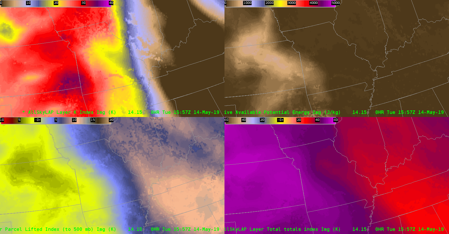
Tag: All-Sky LAP
AllSky vs. ProbSevere: Which MLCAPE is best and where?
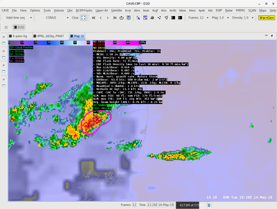
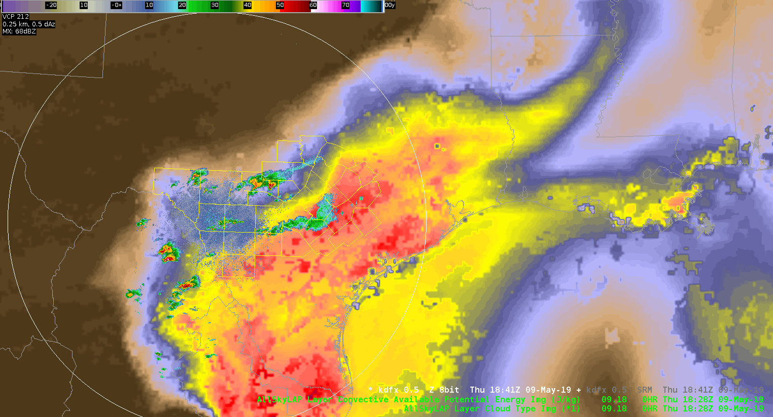
When utilizing the AllSky CAPE image product (MLCAPE), and comparing it to the ProbSevere MLCAPE values for reliability purposes of both tools, it is noticeable the differences between the two when there’s precip. This is due to the fact that most rain areas will not be able to be sampled by the satellite (clear/cloudy), and will be utilizing the GFS data in these areas where ProbSevere is located.
One way around this difference reliability issue is to scan the surrounding areas that are utilizing satellite data (preferably a “clear” spot), and in those cases, the MLCAPE values sampled seemed more comparable to the ProbSevere MLCAPE (RAP) of the storm than that of the GFS sampled MLCAPE data. The GFS sampled locations almost always show a lower MLCAPE value than the ProbSevere MLCAPE. The downside of sampling farther away from the storms/precip areas is that you are sampling rather far away from the storm environment. It’s also difficult to say that the ProbSevere MLCAPE is more accurate or not and what the reliability factors may be.
Below is an example of a storm over TX that is sampling the MLCAPE of the GFS (green text) and of the ProbSevere RAP (white text). -shearluck
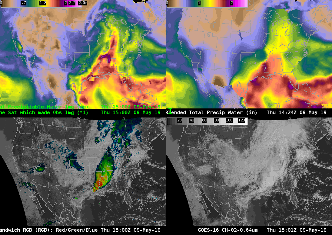
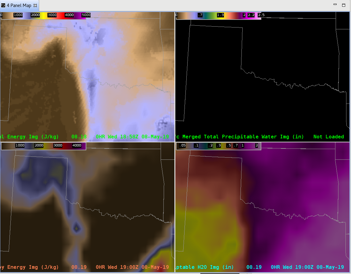
Four Views of TPW
After making some adjustments to the color scaling, we’re able to mix model and analysis products of TPW. The GOM was mostly clear, while clouds covered most of the land. A very moist airmass was onshore, the Hammond LA GPS site measured 2.25″ of TPW.
The GFS and HRRR forecasts both indicated this maximum. The All-Sky LAP also did well, although it’s field is a reflection of the good GFS forecast. The Merged TPW did not generate these very large purple values (> 2″ of TPW) except in a very small area. The polar orbiter TPW retrievals used in Merged TPW must not have sampled these large values to advect in. The operational blended TPW (which relies heavily on GPS sites for the analysis over land) also showed a maximum. This points to the possibility that including the surface GPS network into Merged TPW and All-Sky LAP might be a way to increase the precision of these analyses.
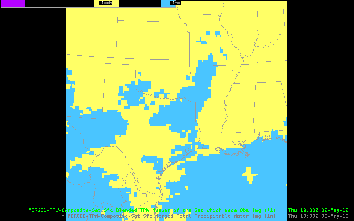
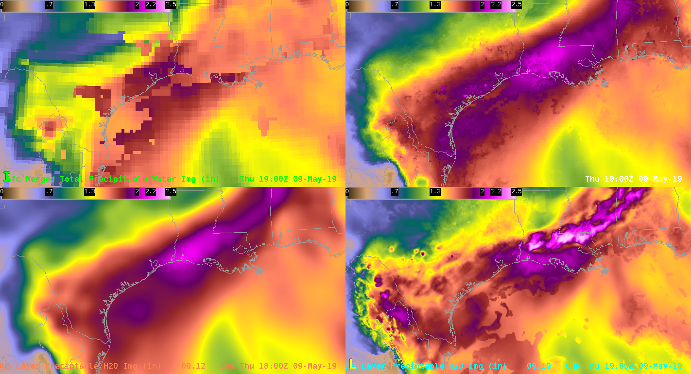
Analyses and forecasts all agreed well on the drier air over the central GOM.
JohnF
All Sky CAPE dropout between time steps
I would like to be able to load ALL-Sky LAP Data Type and CAPE on top of radar data. An unfortunate annoyance is that if the time stamp is too far from the radar product time stamp, the All-Sky products completely disappear, and in fact, if too far away, it won’t load at all. I would like the ability for the latest All-Sky products to display, despite the time lags between the the two. In other words, I would rather have the latest “old” data from All-Sky rather than display nothing.
ZDR_Arcophile
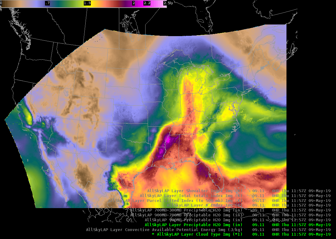
Comparison of ATPW and Blended TPW
I was finally able to take a look the ATPW (top left) and compare it with the operational blended TPW (top right). My first impression was that both products show similar large scale patterns with a large plume of moisture extending from the Gulf of Mexico into the Ohio River Valley. The ATPW also tends to show a little more detail in the moisture field compared to the blended TPW.
At 15Z ATPW shows an area of lower moisture over the Texas Gulf coast which is sort of fills in by 17Z, likely due to upstream moisture being advected into the area. In contrast, this moisture is continuously present in the blended TPW. ATPW generally had PWATs around 1.5 in, while the blended TPW had PWATs around 1.7-1.8 in. In contrast, 12Z RAOBs along the coast had PWATs that ranged from 1.6 inches at KBRO to around 1.8 at KLCH. These values seems to match better with the blended TPW product. I suspect that the upstream convection over Louisiana and lingering clouds over the coast impacted the ATPW that was corrected in the blended TPW.
Update…Below is a loop of the LAP All Sky T PW. This loop shows a similar pattern to the ATPW and Blended TPW with a large are of gulf moisture moving into the Ohio River Valley. It is interesting/good to see that the LAP All Sky TPW is picked up on the sea breeze kicking in along the Gulf Coast. Despite the subtle differences among the three products the fact that they show similar patterns gives increase confidences that we will likely see a large area of flash flooding across portions of the south if storms are able to develop.
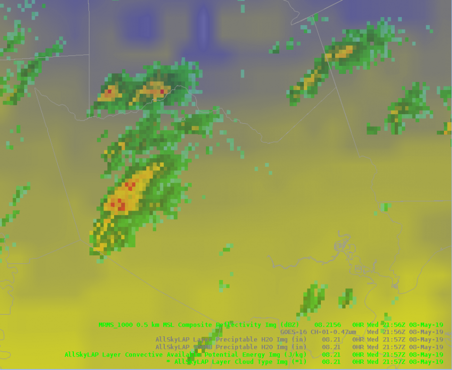
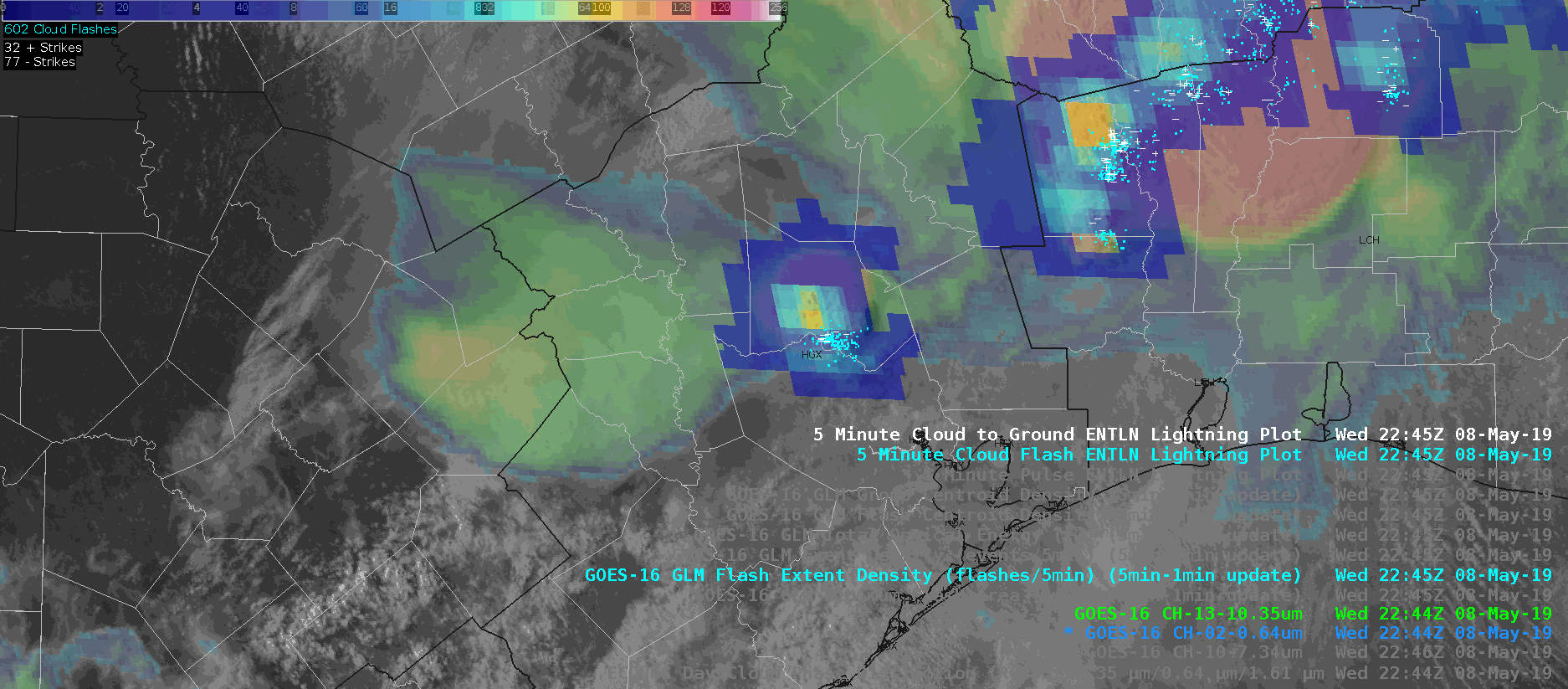
The Life and Death of a Gulf Storm Through the Eyes of Experimental Products
In this case of a rapidly developing storm, GLM data was leaned on to issue a SVR Warning on what otherwise may have been a marginal storm. AllSkyLAP showed the storm was developing in an area of MLCAPE values over 2000 J/kg, and ProbWind model had rapidly increased to ~50%. GOES-16 1-minute imagery showed rapidly cooling cloud tops, with a sharp increase in lightning activity. Given GLM values comparable to other severe storms on the day a SVR warning was placed on the storm. The warning was sent out relatively early to try to capitalize on lead time.
Radar w/ ProbSevere:
IR-Sandwich:
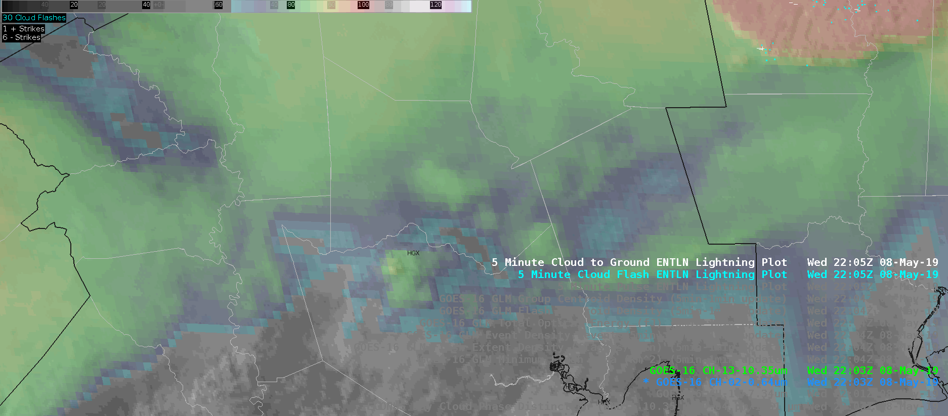
Flash Event Density:
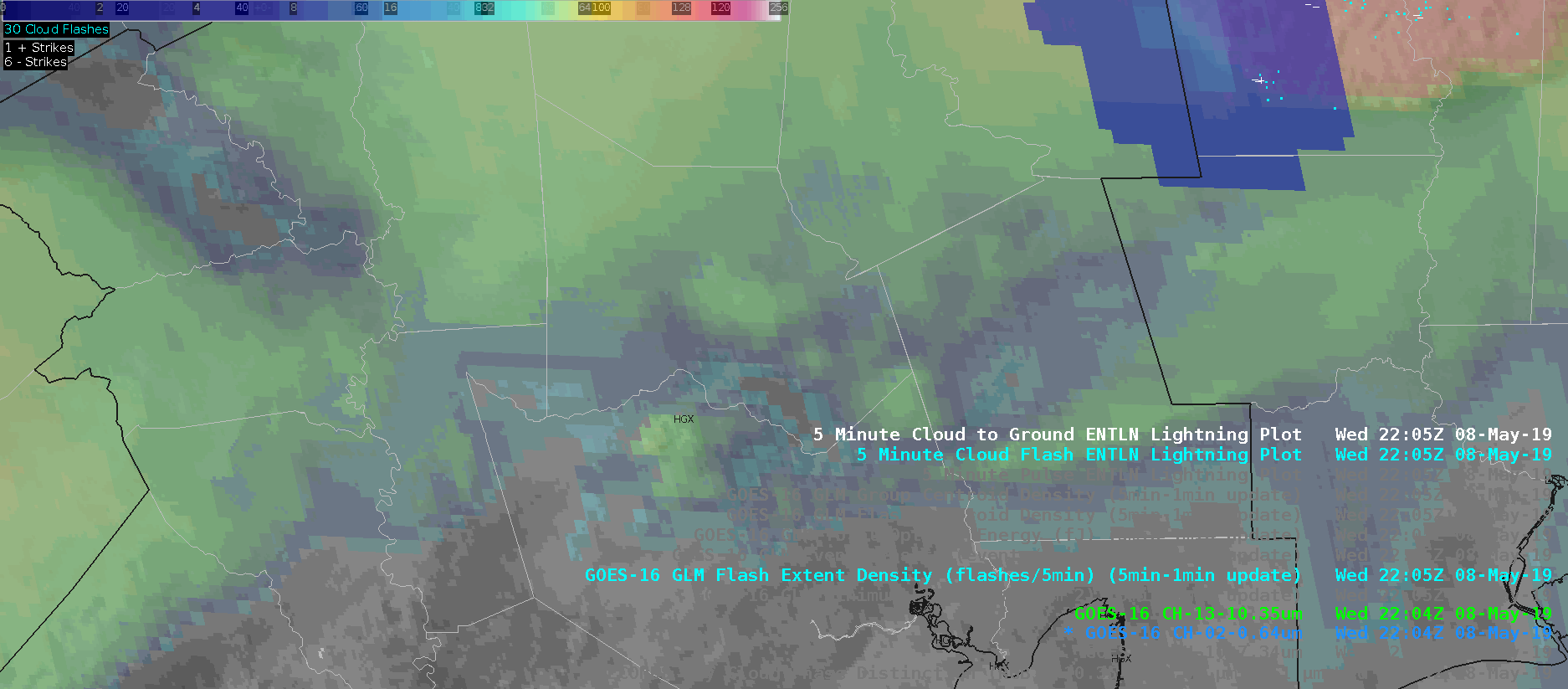
Minimum Flash Area:
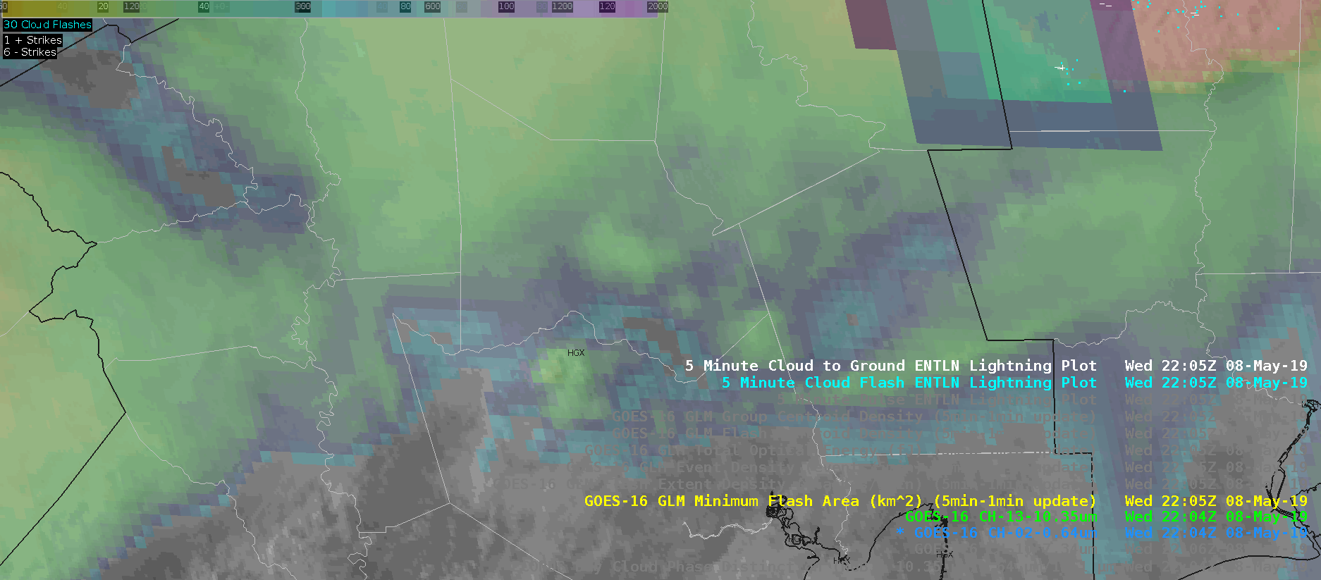
Event Density: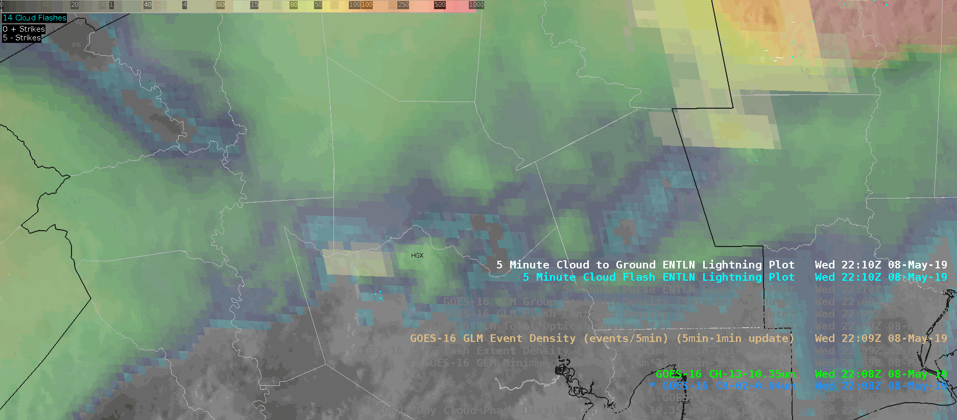
Total Optical Energy (too fast, whoops!):
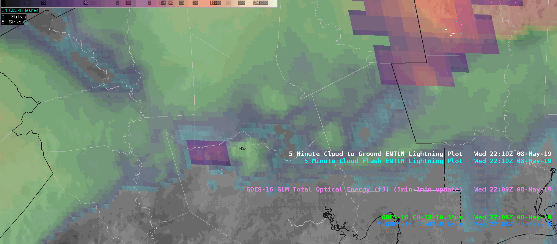
AllSkyLAP CAPE:
ProbWind Model Increase:
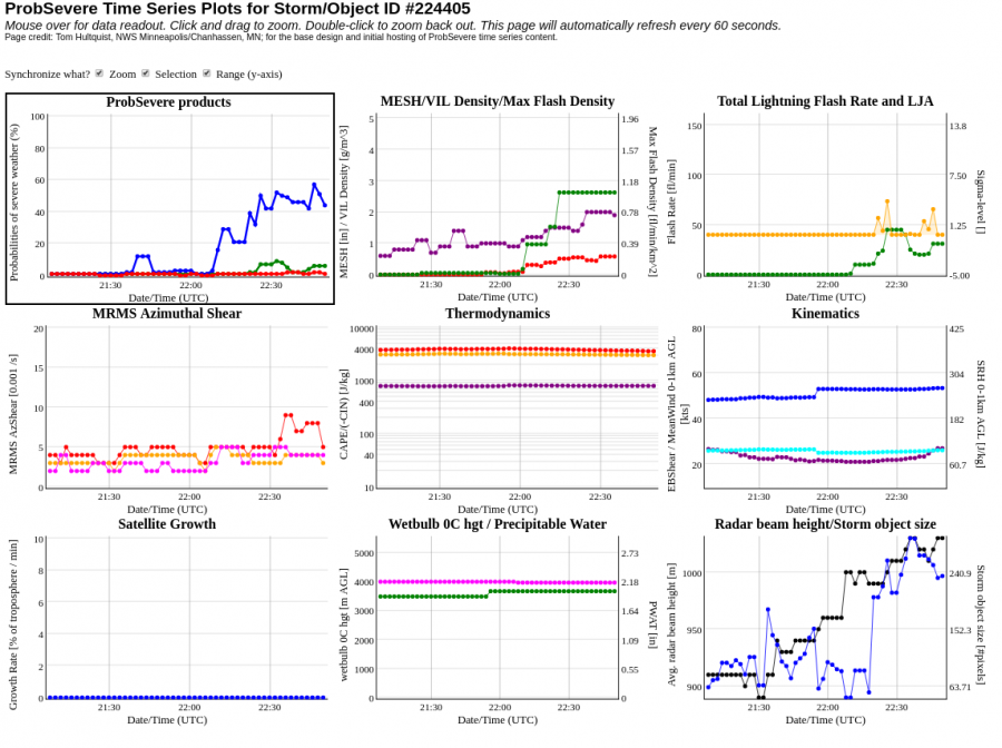
UPDATE: Shortly after warning on the storm, it completely fell apart after failing to become rooted in the boundary layer and all indicators (i.e., ProbSevere, GLM imagry) dropped to null. Initial warning was shamefully cancelled.
Really living up up to my name!
Radar w/ProbSevere:
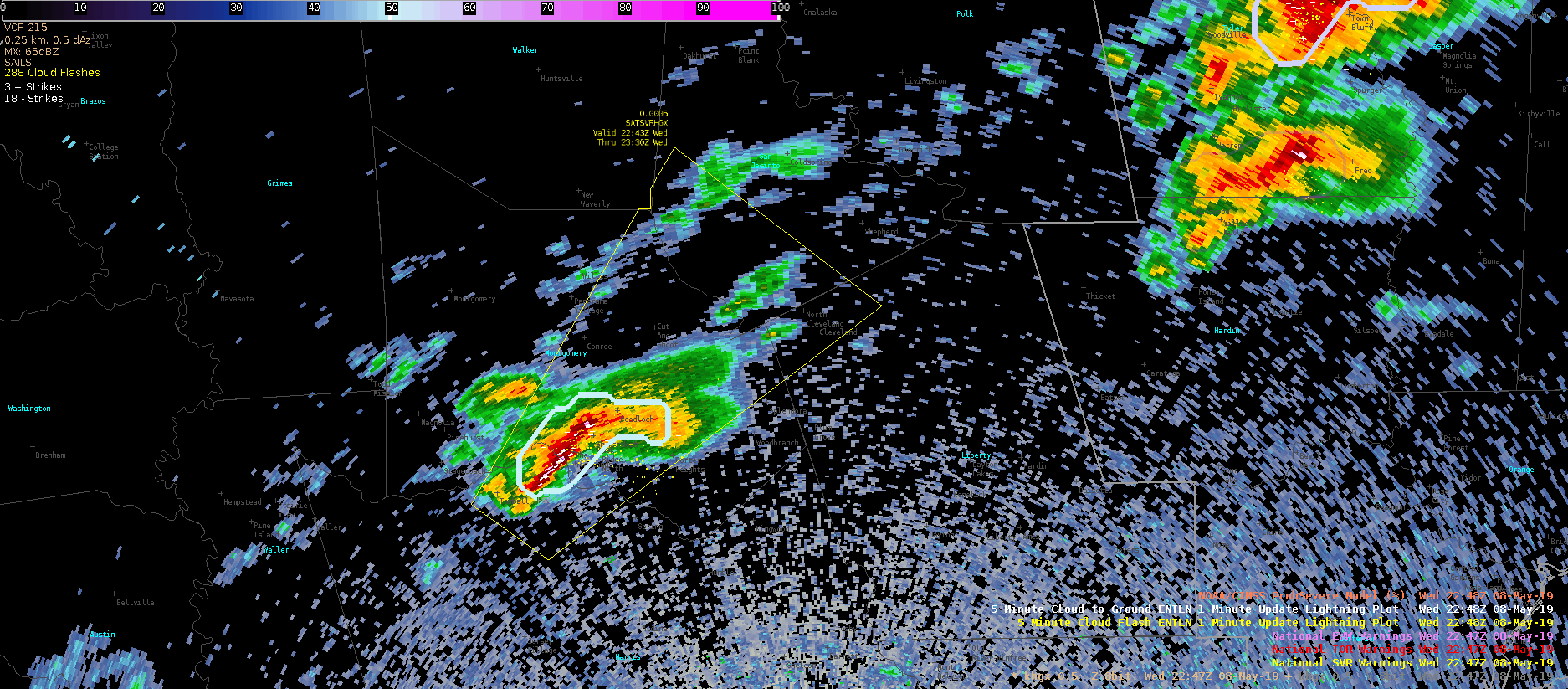
Flash Event Density:
ProbWind Model Increase:
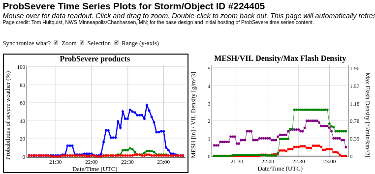
#ProtectAndDissipate
Six Hours Later – Same Surging in All-Sky LAP TPW
At 2127 and 2157 UTC on 8 May (exactly six hours after it was previously noted), a surge in TPW in a cloudy region (Northeast TX region). This might be a predictable behavior in All-Sky LAP and points to improvement needed in how it handles new model cycles. Similar jump behavior was noted in All-Sky LAP CAPE.
2127 UTC 2157 UTC
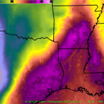
JohnF.
Situation Awareness using AllSkyLAP CAPE gradient
As a good tool for a mesoanalyst, the enhanced gradient for CAPE within AllSkyLAP would indicate an area of focus for discrete convection forming along the southwest flank of the line of convection that fizzled earlier. This area would be a place to focus for future possible convection.
ZDR_Arcophile
NUCAPS in the Forecast Process
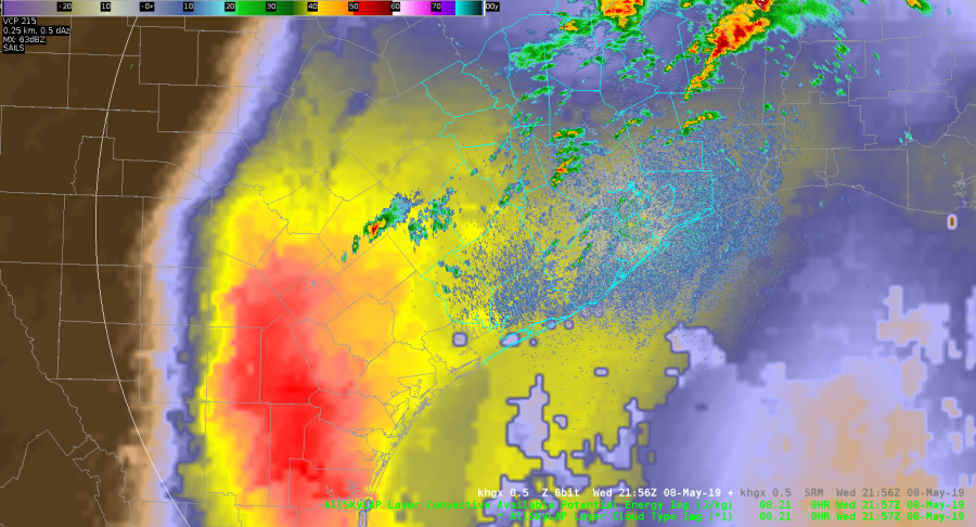
I know, I know; a lot of posts about the GLM. What can I say…I’m a lightning person. ANYWAY, let’s look at some other things that we are testing; today it is NUCAPS soundings. Pretty handy when you don’t have a sounding station nearby and if skies are clear (well, mostly clear…it works with clouds in some situations); you can get a sounding profile for your area. Nice! The caveat is that you need to have a satellite overpass across your area and that is the tricky part. There are only a few satellite overpasses on any given day and you have to be right under the overpass to get the best data but we can make it work. Here is one from today and we’ll look at the point right on the TX/OK state line.
With a possibility of storms across western Oklahoma along the cold front as it moves east, we need a point somewhere in the warm sector with a close enough METAR site that we can adjust to if needed. That point along the TX/OK state line should work…
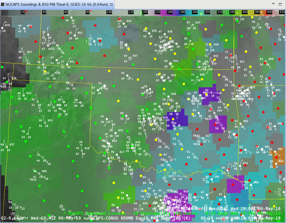
Here is what the original, unedited sounding looks like:
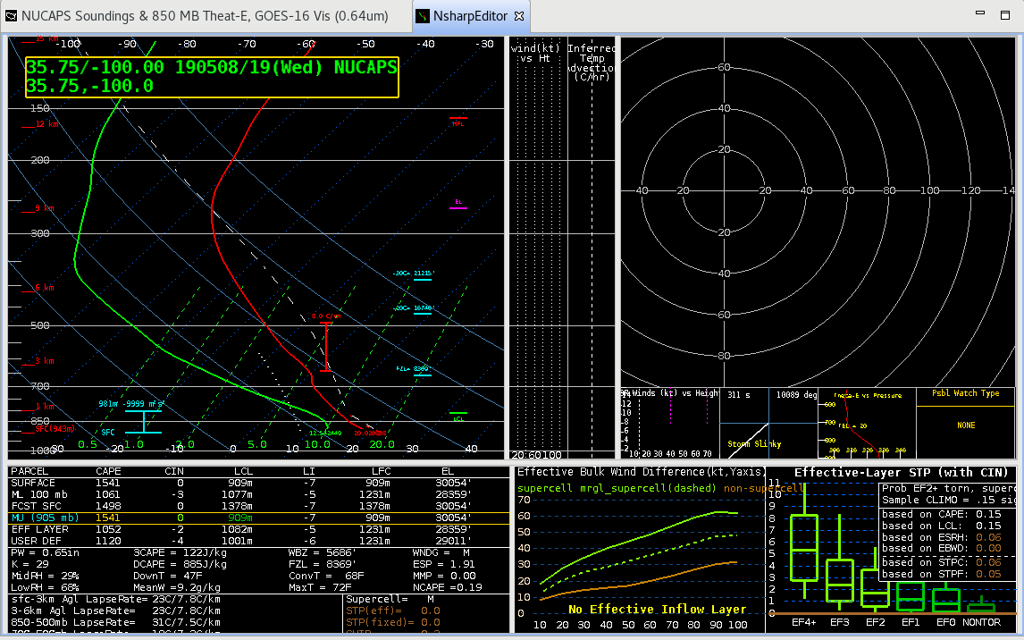
It’s not too bad; comparing to the 12Z Amarillo and Norman soundings (not shown), the soundings do have an EML between 3-4 km which the NUCAPS sounding temperature profile does hint at although it doesn’t have the dry air associated with it, and the NUCAPS sounding does have the tropopause a bit lower than the actual soundings. Overall however, it looks at least somewhat representative. However, the one area it needs some work is the surface. Dewpoints are a bit low with the sounding around 54 F but the temperature is within 1-2 F of surrounding METARs. Well, let’s adjust the surface parcel in the sounding to match surface conditions in the warm sector to the east; say a Td of 60 which should advect northward through the day…
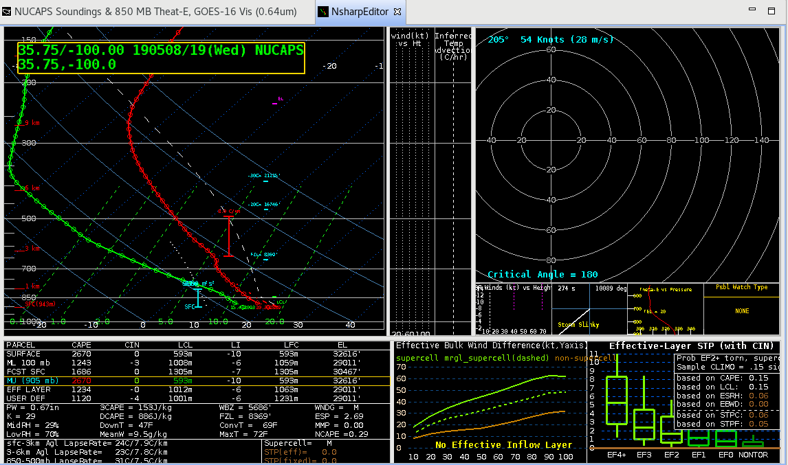
Wham. MUCAPE values jump by almost 1000 J/kg. But that’s pretty optimistic so let’s used MLCAPE which is a smaller, but still respectable increase of 200 J/kg. Not to shabby and should indicate at least the potential for storms to form. But what does that CAPE value compare to other fields? Well, fortunately NUCAPS is available in a plan plot so we’ll look at that along with the RAP40 CAPE values.
Unfortunately the NUCAPE sounding was a bit fast with the dryline pushing east and had CAPE values along the TX/OK state line around 475 J/kg so…no. The RAP40 wasn’t too far off with values around 1500 J/kg.
So, if you are looking for some extra “sounding” profiles in and around your area AND you are lucky enough to be under one of the Polar Orbiter tracks that has a sounder on it, give it a spin. I think I’ll be looking at it quite a bit more…
-Dusty
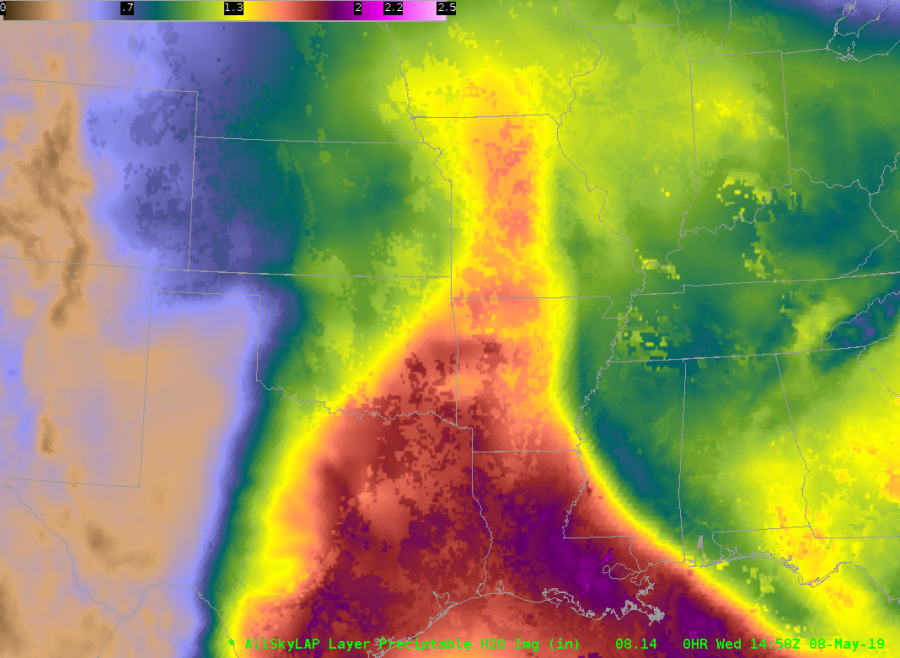
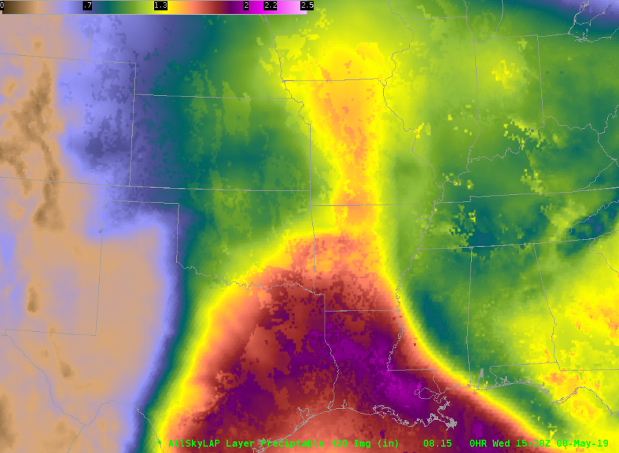
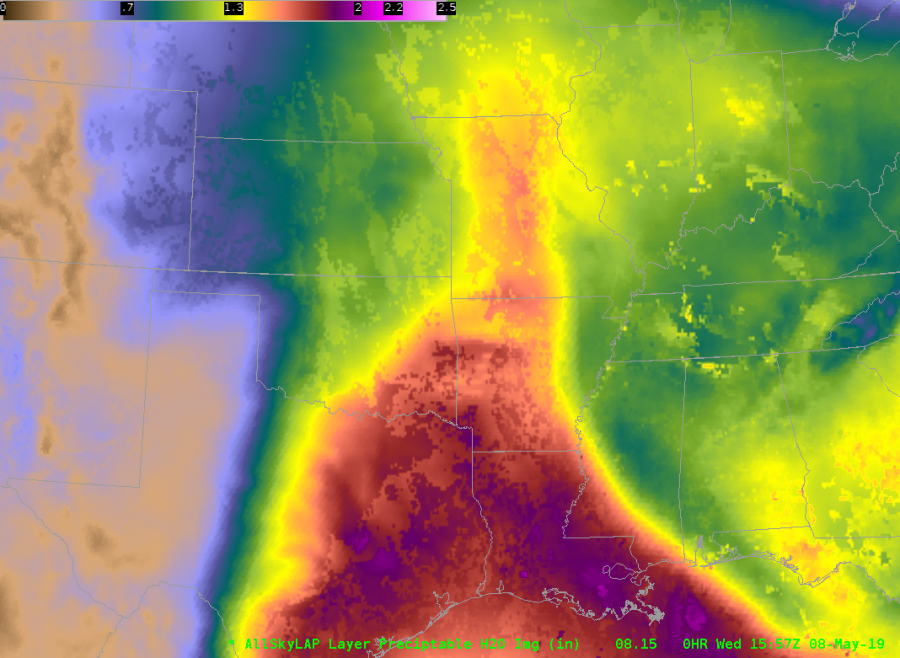
Surging in All-Sky LAP TPW
We’ve seen a couple of cases where the All-Sky LAP TPW surges back and forth unrealistically over a half hour intervals. Here are three frames 1/2 hour apart from 1458 / 1528 / 1557 UTC 8 May 2019. Note the surging TPW over the eastern OK / northwest AR region.
1458 UTC
 1528 UTC
1557 UTC
1458 UTC Data type (yellow / gray cloudy)
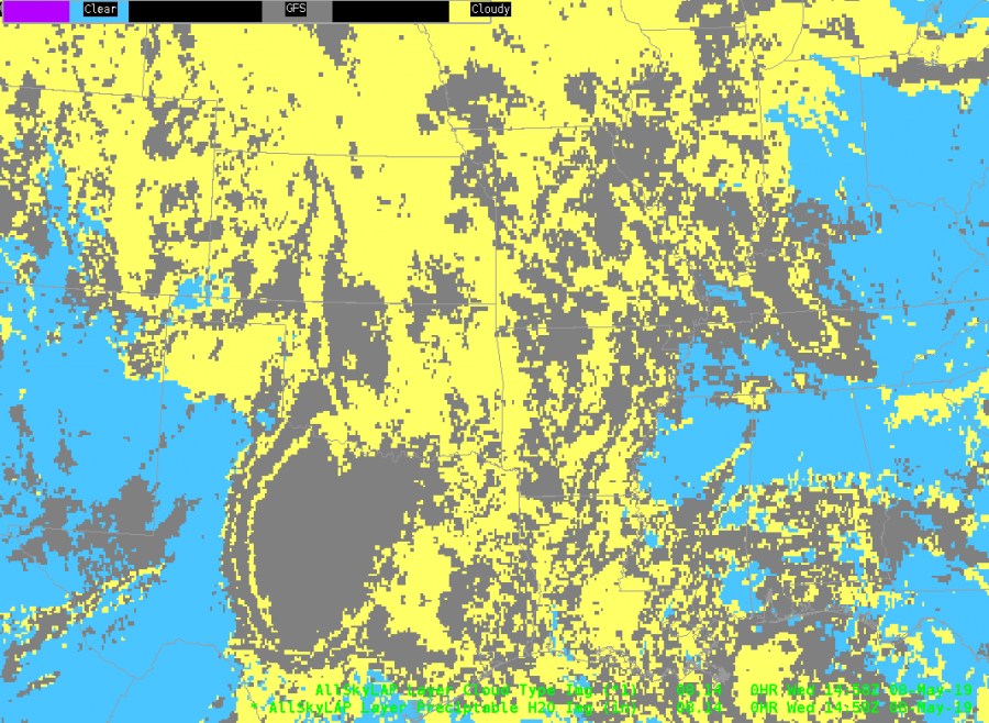
The data type indicates this is in a cloudy region. What’s odd is the middle frame is different, then the last frame is more like the first. Perhaps this is related to handling of the new 12 UTC GFS cycle?
JohnF