An official website of the United States government
Here’s how you know
Official websites use .gov A
.gov website belongs to an official government
organization in the United States.
Secure .gov websites use HTTPS A
lock (
) or https:// means you’ve safely connected to
the .gov website. Share sensitive information only on official,
secure websites.
Today, operations began in the Detroit and Cleveland CWA’s. After activity moved out of the Detroit CWA, that group moved to Wilmington. Forecasters were able to take advantage of most of the products minus lightning and OUN WRF.
Tomorrow, we will start activities at 12:30 in the Dev Lab for the daily debrief before moving to the HWT for the EFP briefing. Operations will likely take place somewhere in the Ohio Valley region as the trough continues its slow eastward progression.
– Bill Line, GOES-R SPC/HWT Satellite Liaison and Week 2 EWP Coordinator
Much of the focus for day one was hands-on training for each of the evaluation products. After some initial familiarization with AWIPS-II, the various PI’s worked with forecasters on how to interpret the products, and what to look for during the week. Forecasters also became familiar with saving images, and posting to the blog. By the end of the day, participants had already made several informative blog posts.
Today we operated in the Davenport and St. Louis CWA’s. Since many of the products being demonstrated have their greatest benefit in the pre-storm environment, forecasters were unable to experience their full potential given the ongoing convection at the beginning of operations. The Prob Severe and Overshooting Top Detection products seemed to have the most utility in this situation. Additionally, forecasters appreciated the availability of the GOES-14 1-minute imagery.
Tomorrow, we will start activities at 12:30 in the Dev Lab for the daily debrief before moving to the HWT for the EFP briefing. Operations will likely take place somewhere in the Ohio Valley region.
– Bill Line, GOES-R SPC/HWT Satellite Liaison and Week 2 EWP Coordinator
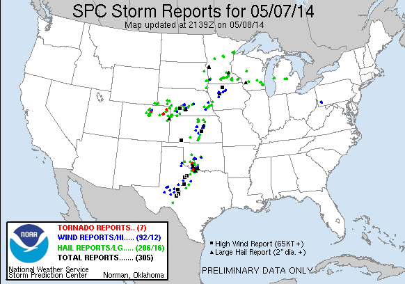
The forecasters were able to complete something more of a stress test on Wednesday, May 7th. We started the day in both the Norman (OUN) and Cheyenne (CYS) county warning areas (CWA) with the CYS team transitioning to the North Platte (LBF) CWA before the end of the operational period. Both teams put together forecast discussions before transitioning to warning operations.
Almost all of the products were evaluated. Blog posts specifically examined the CI algorithm, overshooting tops, pGLM and lightning jump, and ProbSevere.
Tuesday of our first operational week was a bit quiet, but still allowed for testing of many of the operational products. We chose to operate in the Cheyenne and Norman County Warning Areas. The nearcast, CI, and ProbWarn products were heavily utilized during our operations.
Our focus for Day 1 of operations was primarily training. Forecasters were asked to examine each of the experimental products and produce blog posts as they saw interesting features. The goal of this time period was to familiarize the forecasters not only with the products themselves, but also with AWIPS2 and the menu locations plus the process of screenshots and blogging.
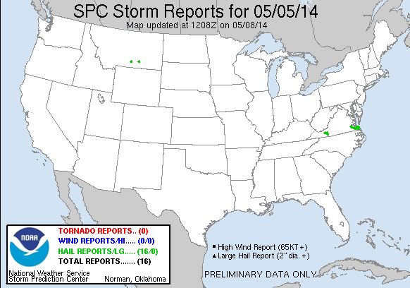
Weather was relatively quiet throughout the CONUS, but we chose to operate in the Sterling, VA (LWX) and Cheyenne, WY (CYS) county warning areas. Though no severe warnings were issued, the forecasters were able to examine almost all the products they would see this week.
SPC Storm Reports 5 May 2014.
In future weeks, it was suggested by the forecasters that a bit more time is spent in hands-on led training. More specifically, the SAD screens should be utilized bringing up each experimental product with a corresponding PI-led discussion.
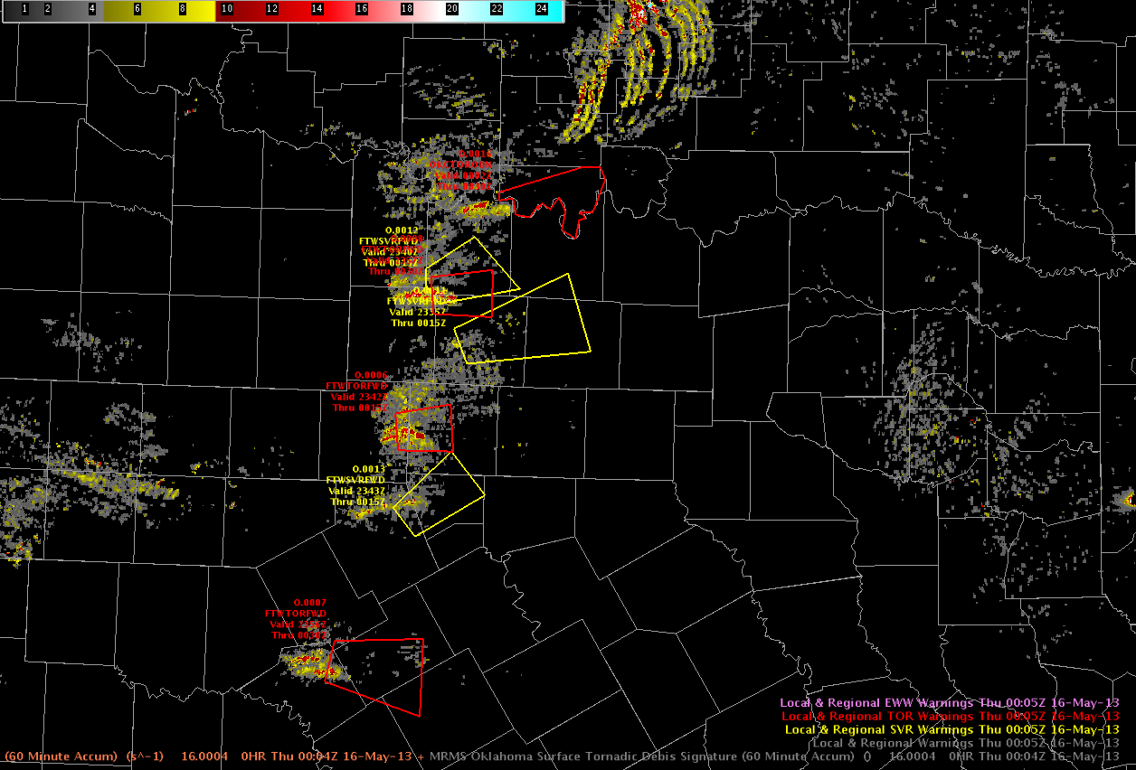
Yesterday was the busiest day of the week 2, if not our entire experiment. We localized to the OUN and FWD county warning areas. Mazur/Ostuno handled to the OUN domain, taking time to examine pGLM lightning data from the OKLMA and work with the NASA-SPoRT moving trace tool. Along the way they issued a number of severe warnings and a few tornado warnings on radar circulations. Scotten/Helge managed the mesoscale desk across the region, providing some detailed updates on the LAPS/OUN-WRF and GOESR CI products. Picca/Leonardi managed the warnings over the FWD CWA. Though activity across this region began slowly, the evening finished with multiple tornadoes still on the ground. They
EWP warnings and Rotation Tracks at 0005 UTC on 16 May 2013.
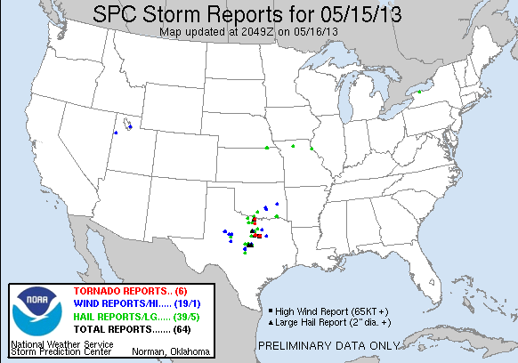
SPC storm reports from 15 May 2013. (Likely to updated as more tornadoes are added)
A bit of the feedback from the debrief:
–The HSDA performed better than previous days this week, however, it may be nice to add an area or volume criteria (compared to individual pixels) to increase forecaster confidence.
–The MESH and lightning flash rates had comparable trends in the OK region, with the flash rates typically preceding MESH by ~1-2 min and reports on the ground by ~15 min.
–The forecasters found manually adjusting the moving trace for every frame to be a bit tedious and would prefer an “apply to all” option. As it stands now, the tool is difficult to use in realtime, but still could be useful for post-analysis and shows great promise for future operations. Forecasters are particularly interested in the capability of displaying trends from multiple fields on the same graph (e.g., flash rates and hail size).
–The LAPS instability field was quite useful when combined with a radar mosaic. Particularly early on in the FWD domain, this field provided clues to when storms would decrease or increase in intensity with time.
–The LAPS 22 UTC 1-km forecast was incredibly accurate 2 hrs out. The updraft helicity product was useful in visualizing the location/strength of the activity.
–MRMS rotation tracks were commonly utilized by the warning forecasters. They found that they helped draw polygon size / shape and reduced FAR area. The rotation tracks / AzShear product was a time saver particularly for situational awareness (calling attention to storms /locations).
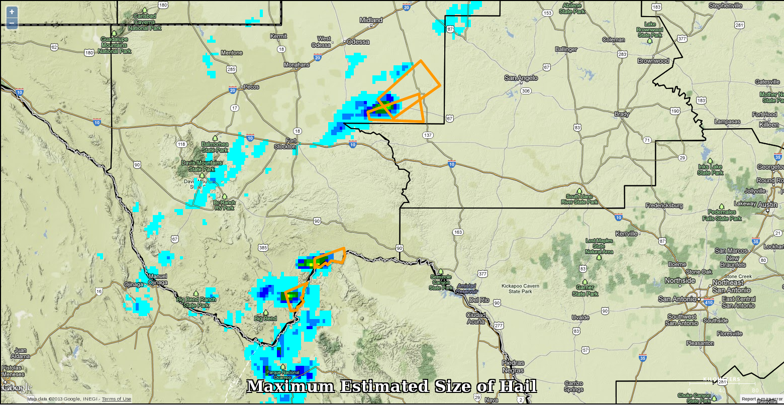
Our second day of operations was a little more interesting. We started off the day with two mesoscale desks: one over the western great lakes and another over south texas. A nowcast and warning desk also set up over the Midland, TX CWA to begin the day. As the day progressed we moved one of the forecasters off the great lakes mesoscale coverage to the san angelo CWA to monitor storms as the progressed into the CWA. The MAF team was able to issue some warnings on storms for severe hail with verification of few reports coming in a bit later via spotter network.
MESH tracks and EWP experimental warnings on 13 May 2013 (1 hr coverage)
The first day of operations worked primarily as a get to know AWIPS2, the products and the PIs. Forecasters were primarily located in the Missoula, MT CWA, with a late shift for a couple over to the Great Falls, MT domain. Storms remained marginally severe through the operational period, with only one experimental warning issued the entire evening. The majority of severe reports occurred post operations as an MCS moved across N.Dakota.
SPC Storm Reports for 13 May 2012.
Even though severe weather was a bit lacking, forecasters were able to explore the GOESR CI /CTC and nearcast products as well as the NSSL MRMS and HSDA algorithms. The simulated satellite (from NSSL WRF) and CONUS LAPS products were also analyzed during operations. Forecasters did not have a chance to review the PGLM / SPORT Lightning Tracking Tool, but it still remains a possibility Wed and/or Thurs of this week.
On Thursday, operations began at noon in the Development Lab, with storms ongoing in the Southern Plains. After the daily debriefing and forecast discussion, we moved to the Hazardous Weather Testbed. Around 1 p.m., the Experimental Forecast Program provided an in-depth weather briefing. This discussion confirmed our decision to operate in the Fort Worth and San Angelo County Warning Areas.
The San Angelo desk consisted of Andrew Hatzos and Jonathan Buseman; the Fort Worth office of Hayden Frank and Marc Austin; and the Mesoscale Desk of Jon Kurtz and Nick Hampshire. Multiple clusters of thunderstorms were already present, including supercellls. With time, it became apparent that the storms in the Norman CWA would allow for an examination of the PGLM data. Thus, the Fort Worth office was shifted to become the Norman office. Not long after this, storms began to develop in the Lubbock CWA, which gave us another opportunity to examine PGLM data. Thus, we decided to send the Mesoscale Desk to Lubbock to cover this activity.
After operations concluded, the forecasters completed the daily surveys. Clark Payne (WDTB) arrived around 7 p.m. to help the forecasters complete the Friday webinar.
On Wednesday, we began operations in the Development Lab. After a short debrief of the previous day’s events, we discussed the Day 1 forecast. We agreed that the Norman and Dodge City County Warning Areas were most likely to receive severe weather. Before we decided where to operate, though, we asked Jimmy Correia (SPC) to give a forecast briefing for the Experimental Forecasting Program. From his briefing, it became apparent that convection was most likely to develop in the Norman CWA first. So, it was decided to operate there initially.
Our forecasters were divided into three teams: two warning teams and one mesoscale team. The North warning team consisted of Hayden Frank and Jonathan Buseman; they covered the warnings in north of I-40 in Norman’s CWA. The South warning team consisted of Marc Austin and Nick Hampshire; they covered the warnings in Lubbock’s CWA, then the southern half of Norman’s CWA. Andrew Hatzos and Jonathan Kurtz filled the Mesoscale Desk. We kept these teams throughout the afternoon and into the early evening. Around 5 p.m., though, it became apparent that Dodge City’s CWA was likely to see severe weather. For this reason, Jonathan Kurtz was moved to the DDC Warning Desk.
A squall line developed just west of the National Weather Center toward late evening, which gave us an opportunity to observe the weather for which we were forecasting. The Norman mesonet registered a 40 mile wind gust, and we observed blowing dust from the observation deck of the National Weather Service. After issuing almost 40 warnings, the EWP crew finished operations.