Big, Bad Flash or Bad Big Flash…Update

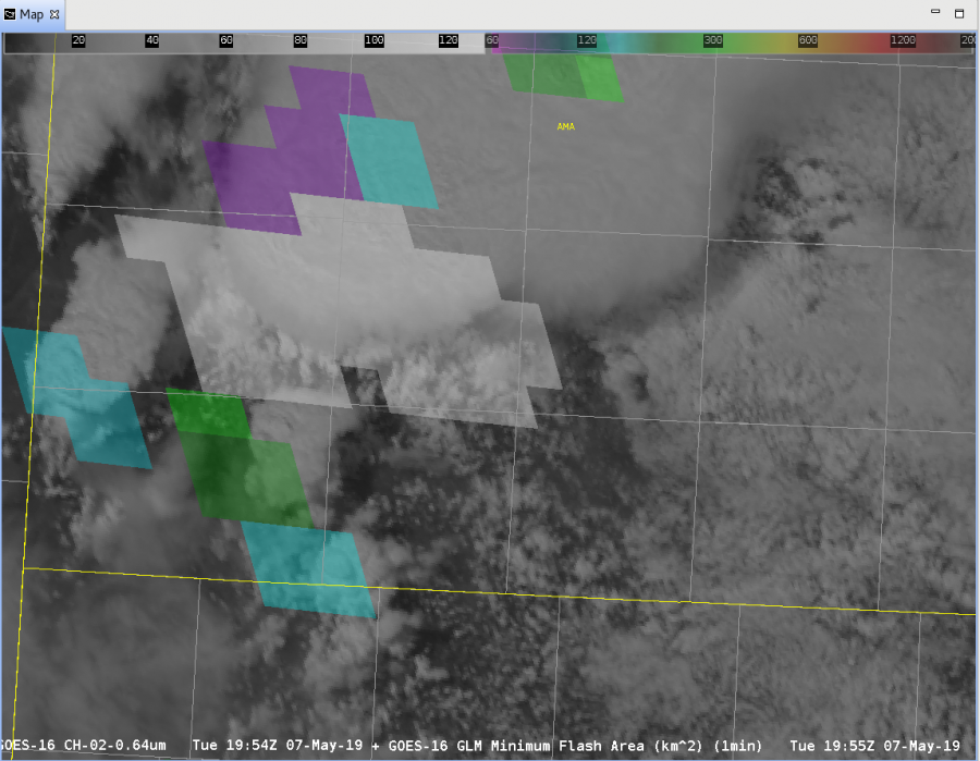
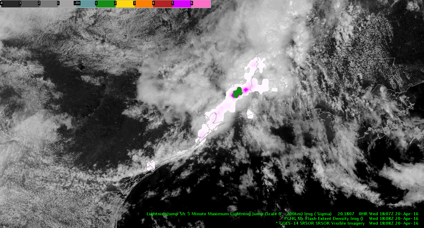
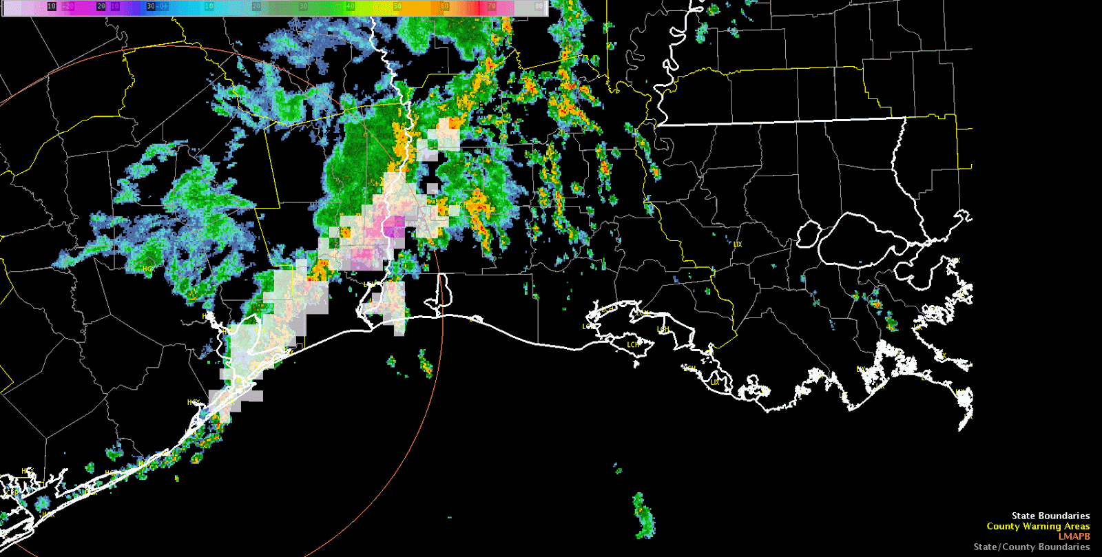
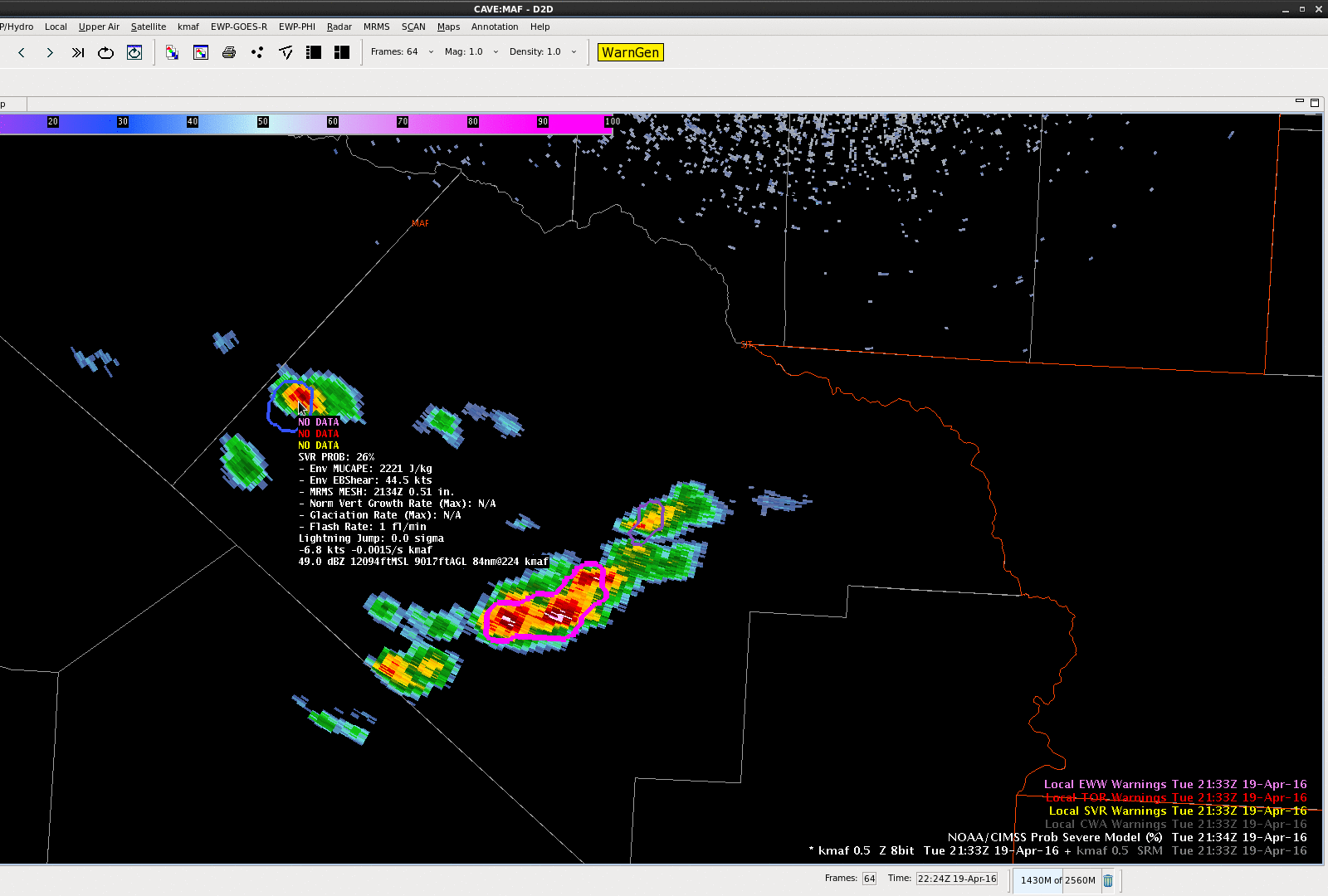
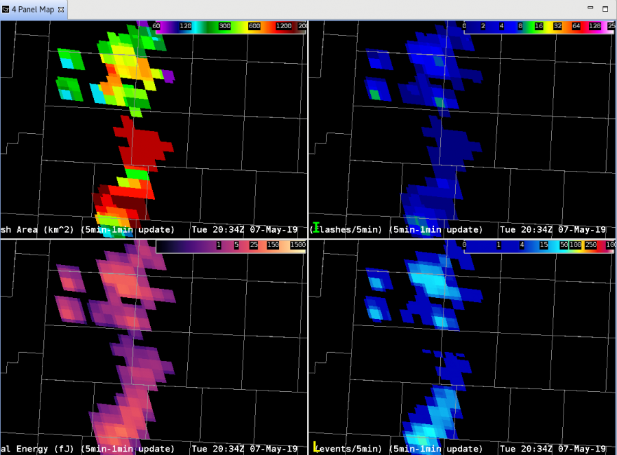
Well, one piece of the puzzle was solved.  A second large flash in the Minimum Flash Area  product occurred between Lubbock and Amarillo, around 1500 km2.  To see what was going on, we now take a look at the difference between GOES-16 GLM:

and GOES-17 GLM:

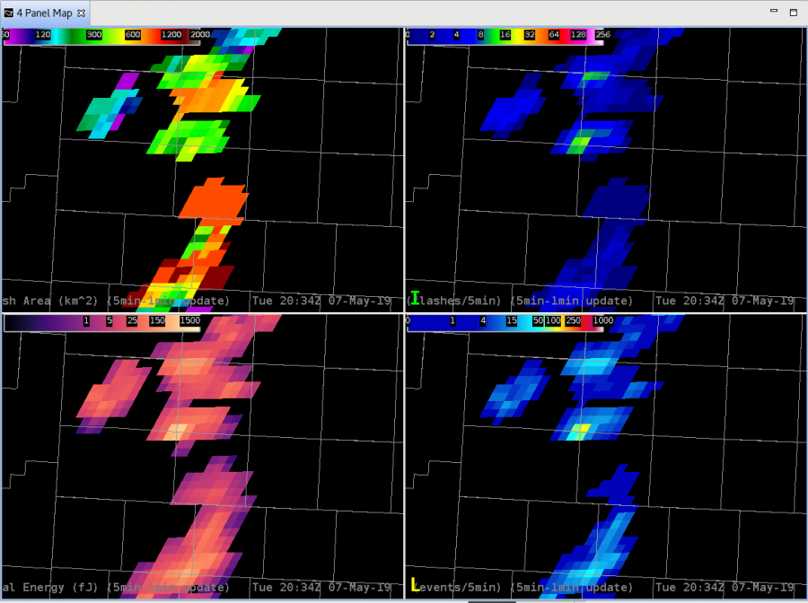
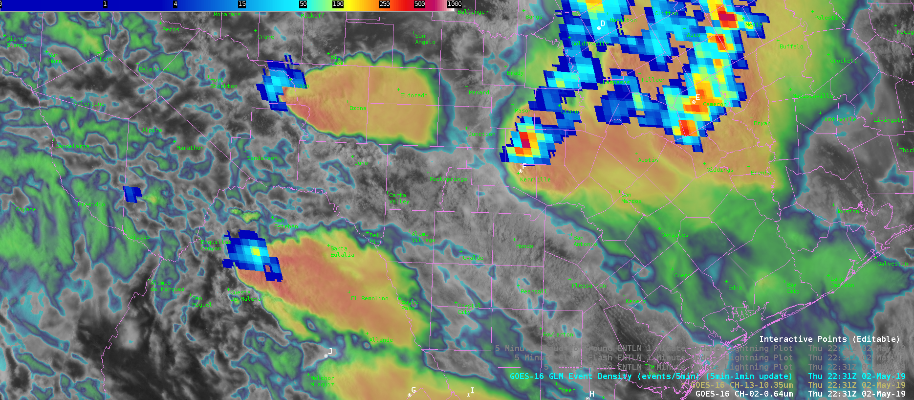
After a LOT of going back and forth, we realized that the color table for Flash Extent Density had the alpha at zero for anything around 1.0 to 1.244.  SO, the previous example that showed no FED actually DID have data associated with the large flash; it was hidden (my bad!).  Fixing the color table to plot any data greater than zero at the darkest color blue and…voila! The large flash now does show a FED of 1.0.  So that problem is now solved.

However, there is still a question as to why that big area flash occurred where it did, when it did, and if it was actually as large of a flash as indicated.  Still something to dig into further!

-Dusty

Big, Bad, Flash or Bad Big Flash

Everything was chugging along great with the GLM and the storms around Amarillo this afternoon as this image from 19:54 shows (TL – Flash Extent Density 5-minute w/ 1-minute update with Vaisala GLD Data overlayed, TR – Minimum Flash Area with ENI Total Lightning overlayed, BL – Total Optical Energy with Vaisala NLDN overlayed, BR – IR/VIS Sandwich):

But then the next set of data arrives at 19:55:

So, that big white area showed up which is a 2918 km2 area flash.  WOW.  THAT. IS. HUGE.  But the question now becomes is that correct or not?  Taking into account parallax and the data from the ground-based networks shows that there was electrical activity in the general area.  However, it isn’t in the area that would line up with the parallax; the ground-based network data should be closer to the southeastern area of the flash.  Also of interest is that there is no Flash Extent Density associated with the large flash but there is an associated area of Total Optical Energy.

One thing we are tossing around here is the possibility of a cloud reflection; here is the 1-minute visible mesoscale scan with the big flashes overlayed:

If there was indeed a flash at this time, the optical energy could have reflected from the originating area off the anvil, and then reflected back off the low clouds around the updraft to the GLM instrument.  However, the fact that there isn’t any data associated with this flash in Flash Extent Density is concerning.  Needless to say, the lightning scientists here are all going “Hmmmmmmm….”

-Dusty

Lightning Event Density As A Proxy For Storm Intensity

Lightning Event Density was mirroring the storm near point F for a fair amount of time. Notice how the prob severe graph almost directly correlates to the product. When Flash Event Density decreased, the Prob Severe decreased as well. Greater Flash Event Density seems to correlate to storm intensity.

Lightning Event Density Before Storm Weakens (Point F)
Lightning Event Density After Storm Weakens (Point F)
Trend-line for the storm…notice the drop-off that occurs when the flash event density decreases.

South Beach

Second Significant Weather Advisory Issued – Southern Wisconsin

042516 MKX SIGNIFICANT WEATHER ADVISORY 2

WWUS83 KMKX 252034
SPSMKX

SPECIAL WEATHER STATEMENT
NATIONAL WEATHER SERVICE MILWAUKEE-SULLIVAN WI
333 PM CDT MON APR 25 2016

WIZ060-065-066-252115-
OZAUKEE WI-WAUKESHA WI-MILWAUKEE WI-
333 PM CDT MON APR 25 2016

…SIGNIFICANT WEATHER ADVISORY FOR SOUTH CENTRAL OZAUKEE…
NORTHWESTERN MILWAUKEE AND NORTHEASTERN WAUKESHA COUNTIES UNTIL 415 PM CDT…

AT 333 PM CDT…DOPPLER RADAR WAS TRACKING A STRONG THUNDERSTORM OVER NORTHERN MILWAUKEE…MOVING NORTHEAST AT 30 MPH.

HALF INCH HAIL AND WINDS IN EXCESS OF 40 MPH WILL BE POSSIBLE WITH THIS STORM.

LOCATIONS IMPACTED INCLUDE…NORTHERN MILWAUKEE…MENOMONEE FALLS…MEQUON…WHITEFISH BAY…BROWN DEER…FOX POINT…BAYSIDE…RIVER HILLS AND GLENDALE.

PRECAUTIONARY/PREPAREDNESS ACTIONS…

TORRENTIAL RAINFALL IS ALSO OCCURRING WITH THIS STORM…AND MAY LEAD TO LOCALIZED FLOODING. DO NOT DRIVE YOUR VEHICLE THROUGH FLOODED ROADWAYS.

&&

LAT…LON 4314 8790 4312 8790 4309 8799 4318 8808
4326 8791 4324 8791 4321 8790 4320 8790
4316 8788
TIME…MOT…LOC 2033Z 238DEG 25KT 4318 8800

$$

BMS

042516 SIGNIFICANT WX ADVISORY PROB SEVERE 2

Second Significant Weather Advisory issues for thunderstorm to the north of first Significant Weather Advisory. MESH is now over 0.50″ with Prob Severe at 35%. Went for half inch sized hail and winds in excess of 40 MPH with these. Lightning being presented at 2.0 Sigma for these thunderstorms as they are heading off shore.

Forecaster: Schuerman

Tags: None

Merits of Prob Severe

J-Money:

For much of the afternoon, so far, scattered to numerous storms in central/southern IL have been non-severe in nature, with occasional small hail.  Prob Severe values have been correspondingly low, with meager flash rates, and poor growth rates.

However, just before 22z, a storm intensified in the far northeast part of the ILX CWA.  Prob Severe values rose quickly into the 70s and 80s, as flash rates and MESH values increased.  A warning was issued, based on the environment of cold air aloft, and seemingly more favorable storm-scale parameters for hail, as shown by Prob Severe.

A loop of refectivity at the -20C level, with Prob Severe overlayed, is shown here.  It well correlates with the above descriptions.

-20C Z + ProbSevere

Tags: None

Eastern Amarillo CWA Storm

While we are watching storms in the Lubbock CWA, I kept an eye on a storm over the eastern portion of Amarillo CWA, near I-40.  The ProbSevere was 25% at 2308 UTC and jumped to 84% by 2314 UTC as MRMS MESH and total lightning flash rates jumped significantly (also the effective bulk shear was rather high in the mid/upper 40 knots).  The ProbSevere values continued to increase into the 90% range.  A 1.00″ hail report was received at Interstate 40 at 2325 UTC and after the report was received, a severe thunderstorm warning issued.  The good lead-time for this storm can be attributed to all predictors of ProbSevere–strong satellite growth rates, strong satellite growth rates, increasing lightning in a highly sheared environment and MRMS MESH over 1.00″.

NOAA/CIMSS ProbSevere contours and MRMS composite reflectivity valid 2308 - 2332 UTC 20 April 2016.
NOAA/CIMSS ProbSevere contours and MRMS composite reflectivity valid 2308 – 2332 UTC 20 April 2016. (click for animation)

-Sieglaff

Tags: None

Mesoscale Analysis as of 1830z

J-Money Mesoscale Analysis as of 1830z:

Two regional short-wave features to note in the 700-500 mb layer this afternoon, as per water vapor imagery and meso-analysis data.  The leading system was near the TX/LA border and pushing east, with associated storms being heavy rain producers, given saturated, weakly sheared environment.  Houston LMA and flash rate density products show a fair amount of lightning as well.

Through 19-22z, better convective potential may shift to central/south TX, as a subtle 700 mb short-wave over west TX moves in.  This may interact with a decelerating outflow boundary in the vicinity.  Layered PW data depicts the leading edge of mid-level dry air and presumably steeper lapse rates as well.  Main question is can strong 700 mb cap shown on 12z KDRT sounding be overcome.  Time will tell.   Maybe 19z NUCAPS could help later today?

LayeredPW_CentralTX

1-minutevis_lightning


Tags: None

Mesoanalysis for Lake Charles Area

Latest IR loop shows a tendency for warming tops through mid morning in the MCS followed by a reinvioration of convection with cooling cloud tops evident over the past hour. This is occurring as the convective complex moves toward a low-level theta-e axis evident in RAP mesoanalysis and Layer PW extending from Southwest Louisiana north-northeastward into Central Louisiana. As diabatic heating continues over this area an increasingly unstable enviornment is developing with MLCAPE ~1,000 J/KG as of this writing. Convection has developed in this area east of the MCS this morning so far. The severe threat will be limited given loose storm organization at best due to weak deep layer shear. Isolated marginal damaging wind events may occur, but significant hail size will be difficult to acheive given tendency for short duration updrafts, limited CAPE in the hail growth zone, and limited complex storm interactions/mergers. For this experiment we will be particularly interested early on PGLM lightning data from Houston, CG lightning probability, and lightning jump since severe thunderstorms may be hard to come by. A move to another area is being discussed for later this afternoon once we examine lightning for a little while longer in Lake Charles’ area.

Houston PGLM (and range ring) overlaid on regional low-level reflectivity

-dryadiabat


Tags: None

Another storm in Midland WFO

Just to the northwest of the today’s first big storm, another storm developed in Pecos County, TX.  The NOAA/CIMSS ProbSevere model provided a large amount of lead-time and the forecasters said, “…we were looking a suite of experimental products and had we been more focused on ProbSevere, we would have likely issued the warning even earlier…”  Below is a loop of select times between 2134 and 2224 UTC 19 April 2016 (Figure 1).

Select times between 2134 and 2224 UTC 19 April 2016 NOAA/CIMSS ProbSevere, KMAF 0.5 degree reflectivity, and experimental severe thunderstorm warnings.  The storm of interest has the readout displayed (northwestern storm).
Select times between 2134 and 2224 UTC 19 April 2016 NOAA/CIMSS ProbSevere, KMAF 0.5 degree reflectivity, and experimental severe thunderstorm warnings. The storm of interest has the readout displayed (northwestern storm).
At 2136 UTC the ProbSevere values jumped from 26 to 63% due to strong satellite normalized vertical growth rates and increase of MRMS MESH from 0.51″ to 0.75″.  The ProbSevere values fluctuated slightly, largely in the 60%s until 2210 UTC when the probability then increased over 80%.   By 2224 UTC ProbSevere was 97% for this storm and an experimental severe thunderstorm warning was issued.

UPDATE:  Despite the very rural region, a golf ball sized hail report was received at 2250 UTC with this storm.

-Sieglaff

Tags: None

Looking at Lightning Jump

We’ve got a lot of action going on across our CWA this afternoon, and most of the storms have had at least a 1 sigma lightning jump. Some of them have had a significant jump, up to 7 sigs.

One cell we were tracking (eventually turning more linear) was moving across Perry Co, PA. We spotted an 80 flash/min jump (from 20-100) in 10 minutes.

jumpPerryCo

This area did receive reports of a tree down (~1950z) and pea-sized hail (~1950z) just before that huge jump. There was still a smaller jump taking place at that time (from 10-20/min over 10 minutes).

1950radarPerry 2005radarPerry

We did notice there were some tracking issues in terms of cells merging and determining a jump. We account this to the amount and speed of convection in our area. Visual jumps were spotted on the time series graph, but it did not show well on the LJDA map.

celldetection2004 LJDA2004

-BT

Tags: None