New development over southern MPX

With new development popping up along the outflow boundary from northern storms earlier, used AllSky and NUCAPS to analyze the environment over southern MPX’s area.  That airmass is a little drier and a little less unstable compared to where the earlier complex was.


CHARLEY

Tags: None

Reissue

Have never re-issued a warning for the exact same area before.  Western cells were not moving and still very tall, so re-issued.  MESH still showing potential for quarters or a little more there.

Charley

Tags: None

EAX Mesoscale Type Discussion (Mountain Bone)


Continuing to see clearing behind the decaying MCS as of 21z. This has allowed ML Cape values to jump above the 2000 – 3000 J/KG range along and northwest of I-35 per the All-Sky Layer Convective Available Potential Energy product. This is in general agreement with 18z NUCAPs soundings with further downstream propagation of best CAPE region likely over the next few hours per the NUCAPs forecast products. With that being said, not sold on the availability of an efficient enough lifting mechanism across this region over the next few hours to get widespread initiation underway. Best chance of seeing that will be further east of I-35 where a pretty pronounced differential heating boundary exists per in-situ observations.

Convection development and location is too uncertain to entertain a watch issuance this far north as of 21z Tuesday.

————————————————————————————————–Mountain Bone

Tags: None

FED, ENTLN comparison

Noticed the FED was matching up well with ENTLN data in our eastern cells, but then the cells to the west should have been electrically active as well.  ENTLN data shows several flashes, but FED from GLM is minimal.


Charley

Forecast NUCAPS Info

NUCAPS data indicates well the area that has received rain, and the airmass the current cluster will be going into (the colors just outside of the blacked-out area.

As we were thinking of some tornadogenesis earlier, seeing the relatively high LCLs from this product may deter us from issuing a later TOR warning.

Charley

Tags: None

EAX Near-Term AFD (Mountain Bone)

A decaying MCS continues to progress northeast across the central portions of northernmost Missouri, allowing for destabilization to begin in its wake. This is especially true along and west of Interstate 35 in NW Missouri/eastern-most KS where clouds have cleared for several hours according to GOES_East Channel 2 imagery. With in-situ observations showcasing upper-60s to low 70s dewpoints at the surface across the central and eastern portions of the state, it likely won’t take much in the way of surface heating to allow for convective initiation this afternoon and evening.  Based on downstream NUCAPs soundings, rather robust SFC CAPE values in the 3000 – 4000 J/KG range will likely spread northwestward with time, which should be ample to support some convection this afternoon and evening. Best (early) thoughts on initiation location this afternoon will be across the easternmost portions of the CWA along a line from Boonville to Centerville along the eastern most periphery of the nearly stalled MCS, which could provide for enough lift to get things firing by late afternoon and evening. Also keeping an eye on a downstream shortwave clearly evident in GOES_East water vapor imagery which could push an additional round of multicellular convection through late this afternoon and evening. Most likely to brush the southern and eastern portions of the CWA, which currently finds itself adjacent to a severe thunderstorm watch extending to its south and eastward. .

Any storms that do form or push into the area should have plenty of moisture and instability to sustain themselves. All_Sky TPW and NUCAP soundings show a plume of 1.3 to 1.5 inch PWATT values extending north throughout the entire CWA, which also brings the concern for some additional flooding, especially across the southeastern portions of the CWA which will likely see more numerous coverage of storms. Low 0-1km and 0-6km effective shear values should limit the presence of sustained supercells, however, a strong to severe thunderstorm or two will remain possible this afternoon and evening.

————————————————————————————————-Mountain Bone


Comparing the modified and unmodified NUCAPS sounding from Western Oklahoma on May 23

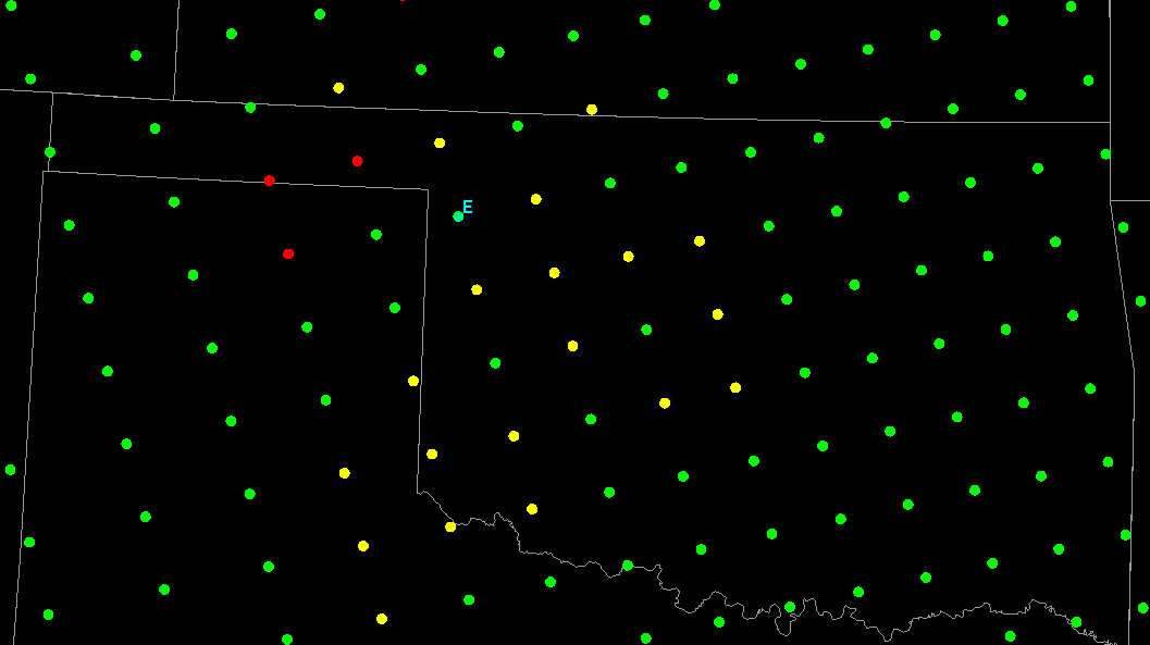
While waiting for any convection to develop in PA, I ventured into western Oklahoma to do a comparison of unmodified and modified NUCAPS soundings in an area under an enhacned risk of severe weather. The soundings examined were near the Texas border (point E below).

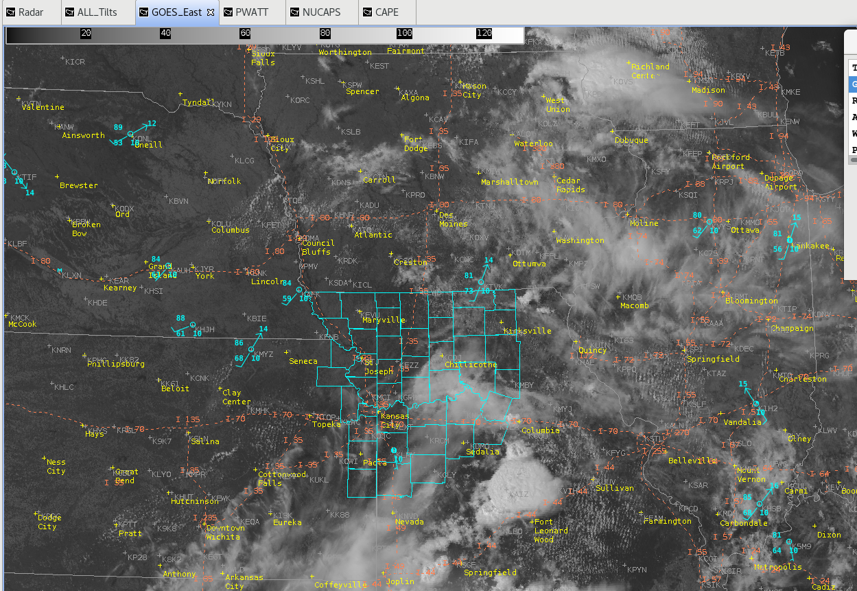
We’ll first look at the visible satellite and observations at 19Z.

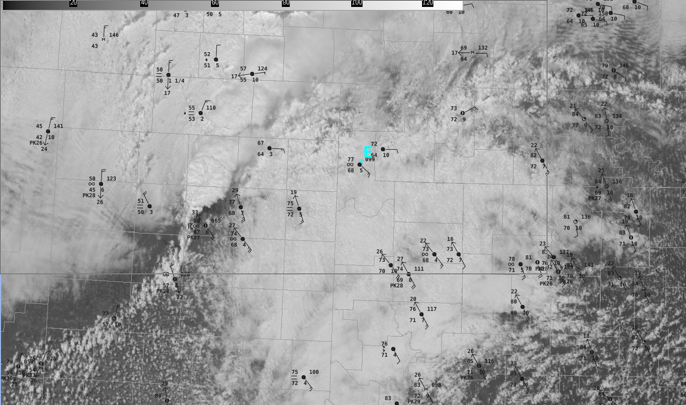
Notice that point E is near a WSW/ENE oriented boundary. Obs near the point show temperatures in the mid 70s, with dew points in the mid 60s. So let’s take a look at the unmodified NUCAPS sounding first.

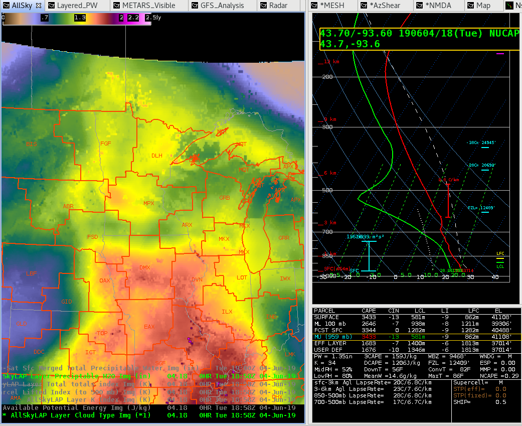
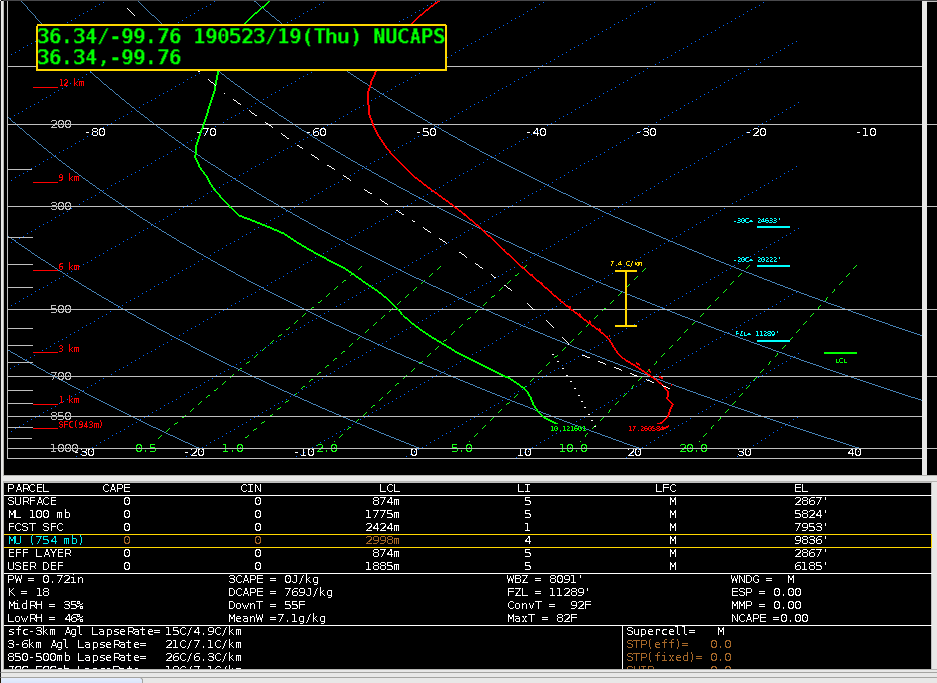
It uses a surface temperature of 63F, and a surface dew point of 50F, both more than 10 degrees below the nearby observations. These inaccurately low values give, as one would expect, no sign of instability (CAPE=0). Looking at the modified NUCAPS gives a different picture, however.

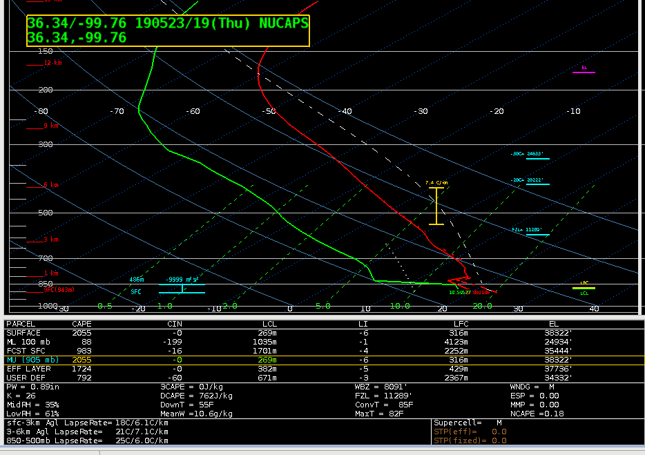
In the modified sounding, the surface temp is 69, and the dew point is 65, which is much closer to the observed surface obs. This changes your surface-based CAPE to 2055 J/kg, vs. 0 from the unmodified. It also has a sharper low level inversion, which one wood expect based on the stratus deck in place.

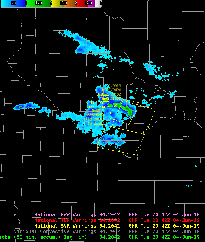
To “verify”, let’s look at the SPC mesoanalysis.

Sure enough, the mesoanalysis shows CAPE at around 2000 J/kg.   Clearly, this is another case where the modified NUCAPS sounding is a noticeable improvement over the unmodified sounding.

Thorcaster

Examining the NUCAPS FCST of CAPE

Below is a loop of the NUCAPS CAPE forecast for the afternoon across the CTP CWA.

Unfortunately, the product is very blocky, and makes it hard to use, especially since some of the missing data is in the time and place where high impact weather may occur. It’s clear that it is trying to show some elevated CAPE moving across central Pennsylvania, but the values are very suspect to me given the missing chunks of information.

Thorcaster

Using Modified NUCAPS to help examine air mass downstream

The air mass in the CTP CWA has been modified somewhat based on earlier convection. Here’s a NUCAPS sounding from central PA (note that it was yellow, meaning it IR retrieval failed due to clouds, but the microwave was successful).

Notice the low level CAP, as well as the modest mid level lapse rates of 6.1 C/km. To get an idea of the air mass characteristics, I looked at a couple of NUCAPS soundings further to the west. The first was west of Pittsburgh along the PA/OH border.

The mid level lapse rates were the same as further east, but the warmer temps and higher dew points were supporting non-zero SBCAPE values. There was still some CIN, however, and the MLCAPE was a paltry 23 J/kg.

Moving further west, I examined a NUCAPS soudning in central Ohio, potentially indicative of the air mass that would move into the CWA later in the day due to the mean westerly flow at mid and upper levels.

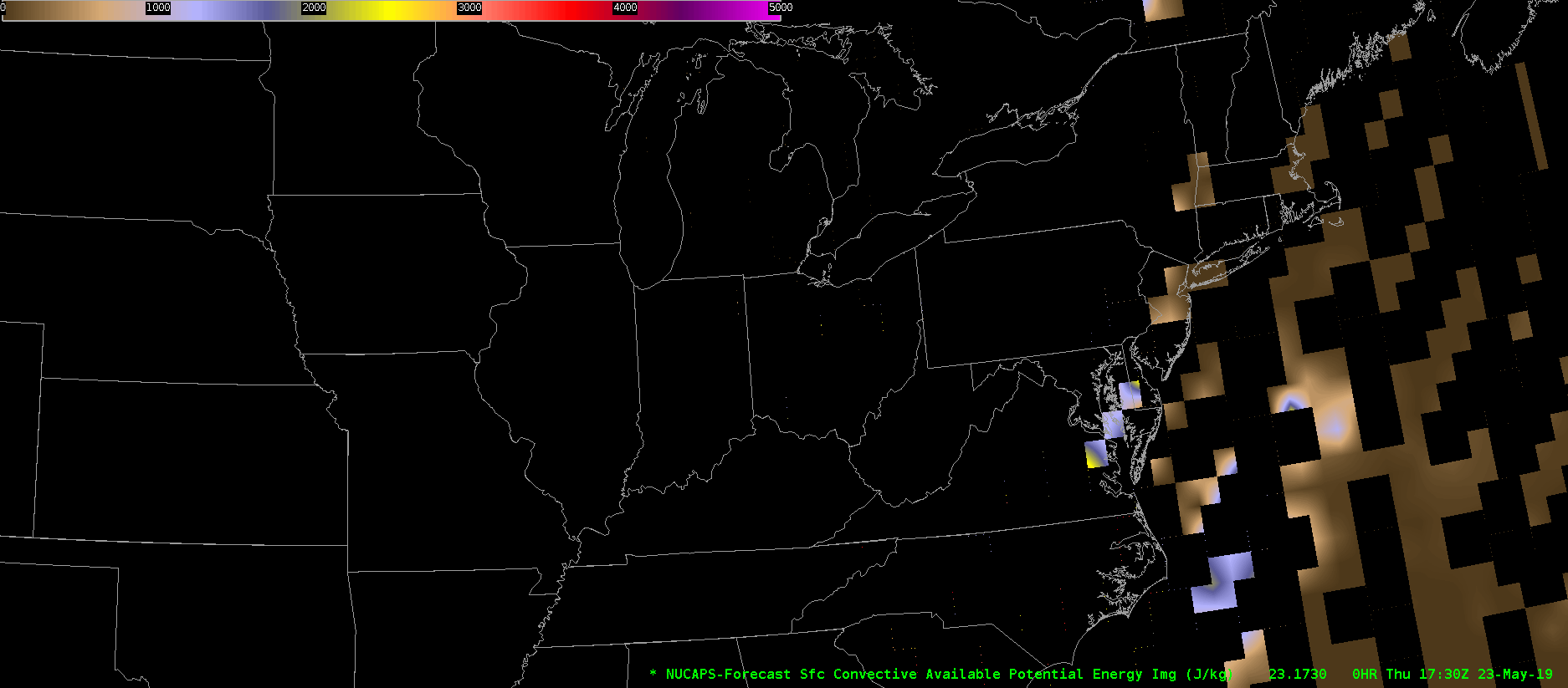
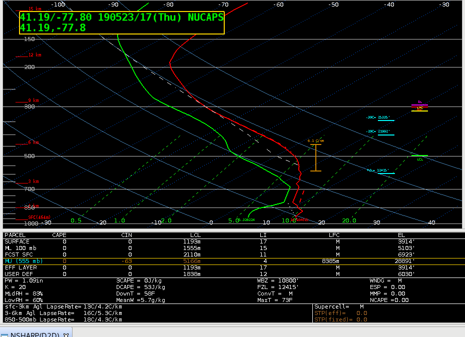
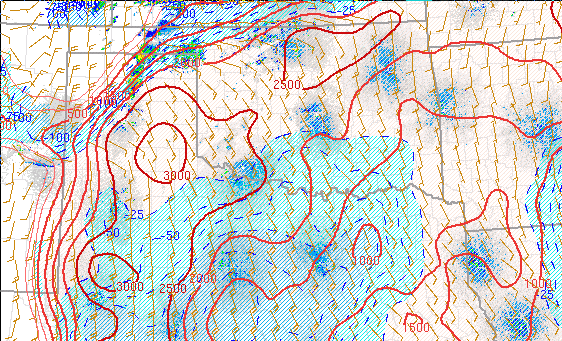
There was a noticeable difference in the mid level lapse rates, with a more significant value of 7.1 C/km.  Also notice the DCAPE was in excess of 1000 J/kg, compared to values of 500-600 J/kg further east. This would indicate that there will be at least a threat of severe winds with convection that develops later in the day in the CTP CWA despite the early in the day convection that modified the air mass during.

Thorcaster