Outlook – 8 May 2008

Two areas of concern grabs our attention today. One area is associated with the departing system toward the east coast where a slight risk has been laid out from AL to VA. Storms were already occurring in AL with several TORs at briefing time, however the threat may focus more in the Carolinas and VA by the time any prob warn activities commenced. The second area is a slight risk area in KS and northern OK. This area already has convection forming in eastern CO. The moisture’s a little light but lapse rates are much steeper than the eastern risk zone. Both areas have sufficient shear for supercells.

The shortwave trough in CO is progged to move well to the north of the PAR and CASA areas and the probability of convection is small. The most likely time for convection in these areas would be after 0300 UTC.

We will probably go with probability warning activities following the SHAVE experiment.

At 2200 UTC, SHAVE was already active on two large hail producing supercells in western KS. Probwarn activities are focusing on the DDC area again.

Jim LaDue (EWP Weekly Coordinator, 5-9 May)

Tags: None

Outlook – 7 May 2008

Today features a closed low over Lubbock in the morning due to move east across southern OK in the afternoon. The surface cyclone is remaining surprisingly stacked up underneath the upper low with a dryline extending south from Altus to west of MWL while a stationary front extends northeast across OKC. This synoptic low is unique in that significant CAPE lies behind the dryline and under the upper low. Cold core convection is forming northwest of Abilene to CDS as a result. More convection is forming along the dryline and a tornado watch is out for areas east of it in an environment featuring significant shallow and deep shear. The hodographs show a little backing at midlevels due to cold air advection in advance of the midlevel cold core. Otherwise the environment is favorable for supercell tornadoes in SC OK and north TX.

We’re expecting the CASA network to be active with convection forming on the dryline in its southeastern sector and potential cold core convection coming in later. CASA and PAR operations are underway as a result.

Jim LaDue (EWP Weekly Coordinator, 5-9 May)

Tags: None

Outlook – 6 May 2008

Today features a long north-south dryline from the Rio Grande southwest of MAF to western Nebraska. A northern stream shortwave is setting off strong convection embedded in strong deep shear though with relatively high dewpoint depressions. A jet exit region extending over west TX is setting off convection in the MAF area with a little better shear and moisture. We’ll be targeting the MAF and LBB CWAs and focusing on tornado and hail threats.

Jim LaDue (EWP Weekly Coordinator, 5-9 May)
Tags: None

Outlook – 5 May 2008

There were two areas in consideration today: eastern Carolinas and the high plains from KS to eastern NM. A boundary aligned NW – SE set up from northern OK to near GCK and intersected another boundary going toward LaJunta, CO. The intersection point near GCK initiated a storm. Other storms formed near Springfield, CO and in Woods county, OK. The Woods county storm is starting to look supercellular with a TBSS. The convection in the Carolinas is composed of ordinary cells.

We figure on starting operations for Northern OK and SW KS given the NW-SE boundary intersecting a developing low level jet may keep active convection going for a longer period of time than the departing convection in the Carolinas. There’s also a good possibility that the PAR area may be involved and so the warning forecasters would have an easier time transitioning from gridded warnings to PAR activities.

Jim LaDue (EWP Weekly Coordinator, 5-9 May)
Tags: None

Outlook – 1 May 2008

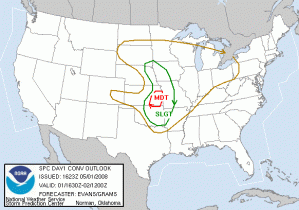
Looks like we may finally have a Central OK event today, but there are several caveats….cap strength and location of the dry line at initiation time. So, both initiation and location of initiation are in question. There is a strong surface low over NC Nebraska/SC SD with a cold front, warm front and dryline extending from it, associated with a very strong negatively tilted trough. SPC highlights a MODT risk in SE KS, and a SLGT up and down the dryline from OK to IA/SD. However, by the time of the briefing several of the deterministic models are indicating that the dryline will retreat west of I-35 by 00 UTC in Central OK.

Because of the uncertainty of severe weather in Central OK, we will plan to have a gridded warning IOP in eastern KS, but will abandon that area if the cap breaks in Central OK, when we will do a PAR/CASA IOP. IOP is planned for 5-9pm, with continued archive case playback from 2-5pm.

Greg Stumpf (EWP Weekly Coordinator, 28 April – 2 May)

Tags: None

Outlook – 30 April 2008

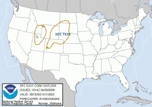
Today will most likely be another non-IOP day, filled with a schedule of more training and archive case playback for all three experiments. There is an SPC DY1 “See Text” area in western Nebraska and SW South Dakota for some high-based marginally severe wind and hail events after 7pm.

We’ll be on an “IOP_standby, for 7-9pm, if severe storms develop in this area. Otherwise, we will continue experiment archive case playback exercises.

Greg Stumpf (EWP Weekly Coordinator, 28 April – 2 May)

Tags: None

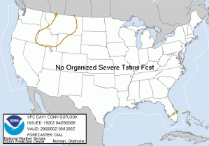
Outlook – 29 April 2008

Bupkes! No IOP planned for today, as there is no chance of severe weather across the CONUS during the 1-9pm shift. And no chance of Central OK weather at all for the next 48 hours.

So, we are planning to put the forecaster/evaluators through the PAR, CASA, and gridded warning archive case playback simulations today to gather feedback for the respective project scientists. There will be 4 shifts today, 90-120 minutes each, and the forecasters will rotate between experiment stations.

Greg Stumpf (EWP Weekly Coordinator, 28 April – 2 May)

Tags: None

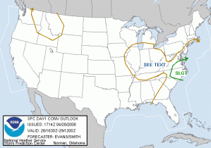
Outlook – 28 April 2008

Our first set of visiting forecasters arrived today. Mike Cammarata (Columbia SC), David Blanchard (Flagstaff AZ), and for today only, Ken Cook (Wichita KS).

I didn’t have much time to brief on the weather situation today, but one this is for sure – no Central Oklahoma storms….for a few days. There is a Slight Risk for Eastern VA/NC (departing cold front), and a “See Text”, formerly a Slight Risk, over the Ohio Valley (cold core upper level low). The East Coast event is currently ongoing with several tornado warnings. However, we need to get the visitors trained on WDSSII and the gridded warning software (from 3-5 pm today), so we plan to let those storms go offshore, and hope for some hailers over the Ohio Valley during an IOP of 5-9pm.

Greg Stumpf (EWP Weekly Coordinator, 28 April – 2 May)

Tags: None

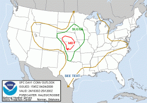
Outlook – 24 April 2008

Another moderate risk day over NW and NC KS and SW NE, with a slight risk extending down into Oklahoma. The big question today is whether the cap south of I-70 will break. The operational RUC says yes, but all the SPC ensemble members and the deterministic NAM and ETA say no. But, we will be on guard for Central OK operations nonetheless.

The progs predict a strong surface cyclone in SW KS, with wrapping moisture and instability northward to the east of a dryline and around the north side of the low. Strong upslope north of the low will be a decent target for today, but the shear isn’t as great up there than points further south along the dryline. However, there is that cap to content with.

The plan is to operate a gridded warning IOP from 5-9 in Western KS and SW NE, where the initial storms develop. If the cap miraculously breaks in OK, we will shift south, and also operate the PAR. No CASA operations are expected, as the radars are not yet ready.

Greg Stumpf (EWP Weekly Coordinator, 21-25 April)

Tags: None

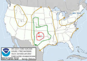
Outlook – 23 April 2008

A Moderate Risk over SW OK and NW TX.

A strong upper level system is moving into the Plains, with split flow. A subtropical stream will affect Texas from the South Plains across the I-20 corridor into the DFW area. Deep layer shear is expected to improve with time. Further north, a secondary area under the influence of the main trough circulation across the CO/NE High Plains is another possible area. There is also going to be enough instability to set off storms in Central OK today although the shear is expected to be too weak for a tornado threat. Therefore, we intend to operate both PAR and gridded warning experiments today with our four “guest” forecaster/evaluators (Burke, Scharfenberg, Kolodziej, Magsig). The first few hours will be devoted to 1) PAR archive case feedback, and 2) gridded warning software debugging. The IOP from 5-9pm will concentrate on live PAR data collection, and a floating gridded warning domain, most likely over Texas.

Greg Stumpf (EWP Weekly Coordinator, 21-25 April)

Tags: None