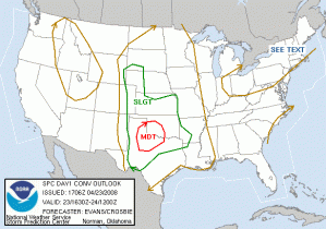
A Moderate Risk over SW OK and NW TX.
A strong upper level system is moving into the Plains, with split flow. A subtropical stream will affect Texas from the South Plains across the I-20 corridor into the DFW area. Deep layer shear is expected to improve with time. Further north, a secondary area under the influence of the main trough circulation across the CO/NE High Plains is another possible area. There is also going to be enough instability to set off storms in Central OK today although the shear is expected to be too weak for a tornado threat. Therefore, we intend to operate both PAR and gridded warning experiments today with our four “guest” forecaster/evaluators (Burke, Scharfenberg, Kolodziej, Magsig). The first few hours will be devoted to 1) PAR archive case feedback, and 2) gridded warning software debugging. The IOP from 5-9pm will concentrate on live PAR data collection, and a floating gridded warning domain, most likely over Texas.
Greg Stumpf (EWP Weekly Coordinator, 21-25 April)

