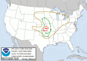
Looks like we may finally have a Central OK event today, but there are several caveats….cap strength and location of the dry line at initiation time. So, both initiation and location of initiation are in question. There is a strong surface low over NC Nebraska/SC SD with a cold front, warm front and dryline extending from it, associated with a very strong negatively tilted trough. SPC highlights a MODT risk in SE KS, and a SLGT up and down the dryline from OK to IA/SD. However, by the time of the briefing several of the deterministic models are indicating that the dryline will retreat west of I-35 by 00 UTC in Central OK.
Because of the uncertainty of severe weather in Central OK, we will plan to have a gridded warning IOP in eastern KS, but will abandon that area if the cap breaks in Central OK, when we will do a PAR/CASA IOP. IOP is planned for 5-9pm, with continued archive case playback from 2-5pm.
Greg Stumpf (EWP Weekly Coordinator, 28 April – 2 May)

