Live Blog – 12 May 2009 (6:28 pm)

23:00 UTC briefing:

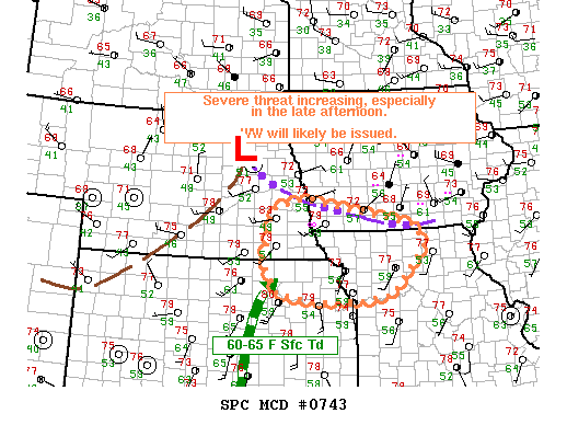
A shortwave trough has come out of southern NM and began to initiate convection as it became juxtaposed over the low-level dryline west of Lubbock, TX.  Initial high-based convection has generated a small but forward propagating cold pool northwest of Lubbock while an enhanced HCR has initiated more discrete, outflow starved and high-based convection from Floydada to south of Silverton.  See image below.

Note that the field here has not only numerous spotters with live video feeds but the VORTEX2 project has targeted this area.

Forecasters will be using multi-sensor products including Z, Z>-20C level, gridded hail, Azimuthal shear, and more.

Forecasters are:

Chris Wielke, EC Edmonton,
Steve Hodanish, NWS PUB
John Billet, NWS AKQ
Kevin Brown, NWS OUN

2330z:  Steve and Kevin will localize to AMA, John and Chris will take LBB’s CWA.

2350z:  John and Chris are seeing MEHS values to 1.2″ for the storm near Turkey.  It’s within the county where the backed winds and near 70 F dewpoints begin.  But the storm is in a small multicell cluster with potential for outflow dominance.  Storm shows only 3kft of 50dBZ above -20C.   Meanwhile Kevin and Steve are limited by the RPS list of only lowest 2 tilts.

0002z:  Both teams drafting respective SVR warnings.  One for the forward propagating storm in Armstrong county based on report as they’ve had issues with products.  MEHS was <1″ but there was an inch hail report.  They’re looking at MEHS and height of 50dBZ > -20 level.  The other one for the multicell event in Hall county.  They based their warnings on the MEHS, all-tilts and height of 50dBZ>-20 C level.

0010z:  Steve and Kevin issued a new warning for Donley and Collingsworth. MEHS and MEHS track for motion.

0011z:  John and Chris issued a new warning for northern Hall and far NE Briscoe counties.  New cell to the northwest based on the core peaking in the MEHS algorithm.

0024z:  John and Chris are looking at a new left mover approaching the southern LBB CWA from MAF.  No warning yet.

0029z:  Both teams drafting warnings for the line bridging both CWAs from Donley to Hall counties.

0039z:  Severe warning issued for Collingsworth county issued by Steve and Kevin for 70mph and tennisballs.  MEHS and 50dBZ height above -20C.

0042z:  Chris and John issuing SVR for Stonewall and SW Kent counties for that left mover coming out of MAFs.  MARC signature aloft, MEHS, and weak rotation.

0045z:  Chris and John impressed by the 50dBZ height 4kft > -20C.

0051z:  Steve says the Donley county storm is going downhill based on looking at FSI X-sections.

0100z:  Chris and John just issued a warning for Motley county minutes before a report came in.

0110z:  Storm acquiring supercell characteristics in northern Cottle county. GRLEVELx MEHS shows 3.2″ while gridded MEHS shows 1.88″.

0017z:  Chris and John issued a SVR

end of period discussion:

What to think of new products?  Took some time to get used to products in order to start warnings.  What value to use in shear?  Nobody knows.  Useful for pulse storms? Yes, it’s nice to isolate the bigger storms when there are many.  What’s popped up at 50dBZ above -20C level?

Nobody looked at biased MEHS.

Technology-wise, it would be nice to have two screens.  Could have NSE data on one screen.  Also add the WDSS signature into the templates.

Jim LaDue (EWP Weekly Coordinator, 11 – 15 May 2009)

Tags: None

Live Blog – 7 May 2009 (8:22 pm)

2245 UTC:  Switch to NC domain.  Severe storms and warnings already in progress.  Substantial convection in KS/MO/NE has not initiated.

2229 UTC: 1″ hail Eastern Johnston NC.  Biased corrected MESH underestimated by 0.5″ and MESH 0.25.

2307 UTC:  30 min rotation tracks coincident with hook echo from KMHX.  0-2 km AzShear ~0.11.  Concern that 0-2km AzShear may have too much contribution from higher level rotation.  Thought of having a very low-level AzShear product in multiradar mode.

WDSS-II Color scale on MR EchoTop at 50 did not agree with cursor-sampled  values.

2320 UTC: NE Craven County storm intensifying based on MESH trends.

MR/MS trend products potentially useful for mesoanalyst forecaster position.

2338 UTC: NE Craven County storm — storm split observed in MESH track

2345 UTC: Southern Suffolk County VA — bowing segments. MARC signature noted in vertical velocity cross section @ 2322 UTC.  Damage reported 2330

0000 UTC: Northen Craven County NC — funnel cloud report in left mover

Since we were in discussion mode, started montoring with live NWS warnings turned on.

It might be useful in some type of IOP exercise to have a WDSS driver to pull up the products faster.  Group discussion mode/thinking out loud not a bad technique.

Possible useful visualization technique:  spatial map of MR/MS trends tendency.

At 0045 UTC:  Group IOP ended. and a final CASA archive case was played back for the rest of the shift.

Dale Morris (EWP Backup Weekly Coordinator, 4-8 May 2009)

Tags: None

Live Blog – 7 May 2009 (5:42 pm)

There was a choice between two areas IOP domain, based on the SPC Day 1 Convective Outlook:  Slight risk in NE KS, NW MO, and SE NE vs using the same Carolina domain from the previous two days.   The choice was to go with the Plains domain based on better shear and the fact that an MD and TOR watch were issued by the end of the briefing.

Initial plans were to start the IOP initially, followed by a PAR/CASA playback to start at 6:30.  Technical difficulties with AWIPS/LDAD prevented the IOP from starting on time.  In addition severe weather did not occur in the IOP domain while troubleshooting occured.  So, we decided to do the PAR/CASA playback first and then do the IOP later.

Because of the AWIPS issues, the IOP will be conducted in a group format with a live blog documenting the forecasters’ warning decisions.

Dale Morris (EWP Backup Weekly Coordinator, 4-8 May 2009)

Tags: None

Live Blog – 6 May 2009 (7:06 pm)

We are currently talking about the different ways to display and interpret the lightning probability product.  The forecasters seem to agree that a swath from 0-15 min, 0-30 min, etc. might be a better way to visualize the probabilities.  The problem of also going from a 100% probability to zero in a single pixel was also discussed.

Kiel Ortega (EWP Weekly Coordinator, 4-8 May 2009)

Tags: None

Live Blog – 6 May 2009 (5:33 pm)

Talking with Tom (WDSSIIB) for a moment.  Due to the technical difficulties that we’ve been having (and may be stabilized for the time being), Tom is just now starting to use the MRMS gridded info.  He has been looking at the RotationTracks, MESH, and Reflectivity at -20C.

Kevin Manross (EWP IT Coordinator)

Tags: None

Live Blog – 6 May 2009 (4:52 pm)

Both teams (WDSSIIA :: Gino/Jeff & WDSSIIB :: Tom/Scott) have been issuing warnings despite the MRMS grids not auto-updating in AWIPS.  They have relied on base data analysis, along with suplementing MRMS grids/trends via GoogleEarth.

We are still focusing on RAH, with storms entering an ubstable environment fromthe west of the CWA.  Greg is troubleshooting the notification of the MRMS grids in AWIPS.

Kevin Manross (EWP IT Coordinator)

Tags: None

Live Blog – 5 May 2009 (5:50 pm) – Start IOP

We have decided to focus on the tornado watch issued in North Carolina.  This target area provides the more storm coverage than the other target of N TX.  Currently our forecasters are getting spun up on the situation and we are hammering out a few AWIPS glitches.

Kiel Ortega (EWP Weekly Coordinator, 4-8 May 2009)

Tags: None

Live Blog – 30 April 2009 (9:00 pm)

Our forecasters noticed that MESH was running around 1.5″ while hail from the storm was around 2.5″.  This is probably due to the strong rotation in the storm per anecdotal evidence from SHAVE.

Greg Stumpf (EWP Weekly Coordinator, 27 Apr – 1 May 2009)

Tags: None