Week 2 Summary: 4 – 8 May 2009

MR/MS

-Trends from MR/MS grids provide an excellent tool for the mesoanalyst and situational awareness given the capability to see the long-term trends

-Avg. trends in a sector/area to see the “average storm behavior might be helpful

-Grids of the time change fields might be helpful (i.e., the change in MESH for a storm in the past 10 minutes)

-Probability of lightning not useful with the put-get type advection; a forecast swath would be much better to see all areas which the storm might move over in the next N minutes

-Divergence fields for MARC signature

-Need to investigate how radar coverage affects MR/MS grids

-Send MR/MS grids to WTDB to help expose to more forecasters?

-Forecasters seem to have their own preferences for what levels and echos they would like to see (i.e., maybe dBZ @ -30C instead of -20C).  MR/MS set up needs to be configurable on the fly.

-Will need a salesman at each office for MR/MS.  They need to be knowlegable and experienced with MR/MS so that they can sell it to other forecasters.

CASA

-Too many panels; all the information took away from the experience with CASA data

-Idea for WG: move to tabs to help sort radar data?

-For wind study, it was suggested to get experienced forecasters (i.e., forecasters from offices who experience derechoes or main climatological threat is wind) to evaluate how useful the CASA data is for wind threat.

LMA

-More trends of the data

Overall/General Comments:

-One team member on Google Earth and one team member on AWIPS worked well

-AWIPS for canned cases

-Visiting forecaster: Can we get flexible shifts for real time events?

Kiel Ortega (EWP Weekly Coordinator, 4-8 May 2009)

Tags: None

Live Blog – 7 May 2009 (8:22 pm)

2245 UTC:  Switch to NC domain.  Severe storms and warnings already in progress.  Substantial convection in KS/MO/NE has not initiated.

2229 UTC: 1″ hail Eastern Johnston NC.  Biased corrected MESH underestimated by 0.5″ and MESH 0.25.

2307 UTC:  30 min rotation tracks coincident with hook echo from KMHX.  0-2 km AzShear ~0.11.  Concern that 0-2km AzShear may have too much contribution from higher level rotation.  Thought of having a very low-level AzShear product in multiradar mode.

WDSS-II Color scale on MR EchoTop at 50 did not agree with cursor-sampled  values.

2320 UTC: NE Craven County storm intensifying based on MESH trends.

MR/MS trend products potentially useful for mesoanalyst forecaster position.

2338 UTC: NE Craven County storm — storm split observed in MESH track

2345 UTC: Southern Suffolk County VA — bowing segments. MARC signature noted in vertical velocity cross section @ 2322 UTC.  Damage reported 2330

0000 UTC: Northen Craven County NC — funnel cloud report in left mover

Since we were in discussion mode, started montoring with live NWS warnings turned on.

It might be useful in some type of IOP exercise to have a WDSS driver to pull up the products faster.  Group discussion mode/thinking out loud not a bad technique.

Possible useful visualization technique:  spatial map of MR/MS trends tendency.

At 0045 UTC:  Group IOP ended. and a final CASA archive case was played back for the rest of the shift.

Dale Morris (EWP Backup Weekly Coordinator, 4-8 May 2009)

Tags: None

Live Blog – 7 May 2009 (5:42 pm)

There was a choice between two areas IOP domain, based on the SPC Day 1 Convective Outlook:  Slight risk in NE KS, NW MO, and SE NE vs using the same Carolina domain from the previous two days.   The choice was to go with the Plains domain based on better shear and the fact that an MD and TOR watch were issued by the end of the briefing.

Initial plans were to start the IOP initially, followed by a PAR/CASA playback to start at 6:30.  Technical difficulties with AWIPS/LDAD prevented the IOP from starting on time.  In addition severe weather did not occur in the IOP domain while troubleshooting occured.  So, we decided to do the PAR/CASA playback first and then do the IOP later.

Because of the AWIPS issues, the IOP will be conducted in a group format with a live blog documenting the forecasters’ warning decisions.

Dale Morris (EWP Backup Weekly Coordinator, 4-8 May 2009)

Tags: None

Outlook – 7 May 2009

It looks like a return to North Carolina today.  Currently, SPC’s day 1 outlook is on the fringes of all of our LMA network domains and the timing is not there for a possible real-time PAR exercise as the models have convection late on the edge of the PAR domain.  However, per NSSL WRF and NWSFO RAH’s local WRF, it appears we will have another opportunity at storms in North Carolina today.  These models are suggesting storms will develop in central NC in the 18-20Z timeframe and then move east.  The models also suggest a complex of storms will form before moving off the coast.  This allows for the possibility of an extended MR/MS IOP with a good mix of storm mode, including supercells.

Kiel Ortega (EWP Weekly Coordinator, 4 – 8 May 2009)

Tags: None

Live Blog – 6 May 2009 (7:06 pm)

We are currently talking about the different ways to display and interpret the lightning probability product.  The forecasters seem to agree that a swath from 0-15 min, 0-30 min, etc. might be a better way to visualize the probabilities.  The problem of also going from a 100% probability to zero in a single pixel was also discussed.

Kiel Ortega (EWP Weekly Coordinator, 4-8 May 2009)

Tags: None

Outlook – 6 May 2009

Again today convection was mistimed in travelling through an LMA area during the morning hours.  Currently, a broken cell squall line is moving through Alabama; this is on the eastern edge of a solid line which extends from just east of Dallas into Mississippi.  Currently a tornado watch is out for the broken line until 23Z.  High-res WRF runs break out convection in NC and VA during the evening hours, which should provide for an evening MR/MS IOP area.

Kiel Ortega

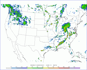
Forecasted 1km reflectivity from EMC WRF
Forecasted 1km reflectivity from EMC WRF valid 00Z 7 May 2009
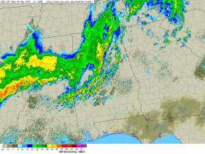
Composite reflectivity at 1510 UTC
Composite reflectivity at 6 May 2009 1510 UTC

Kiel Ortega (EWP Weekly Coordinator, 4 – 8 May 2009)

Tags: None

Summary – 5 May 2009

FAIL.  A rolling snowball of computer problems led to no MR/MS IOP during the evening hours.  However, the day was not a complete loss as the forecasters looked at one more CASA and PAR case, received their introduction to the LMA and went through an introductory LMA playback case.  The forecasters were able to view the MR/MS products in wg and Google Earth, however, the AWIPS problems proved to be a major distraction.

Kiel Ortega (EWP Weekly Coordinator, 4-8 May 2009)
Tags: None

Live Blog – 5 May 2009 (5:50 pm) – Start IOP

We have decided to focus on the tornado watch issued in North Carolina.  This target area provides the more storm coverage than the other target of N TX.  Currently our forecasters are getting spun up on the situation and we are hammering out a few AWIPS glitches.

Kiel Ortega (EWP Weekly Coordinator, 4-8 May 2009)
Tags: None

Summary – 4 May 2009

Our forecasters have done their training today.  They have viewed all into presentations except for the LMA presentation.  They received a fair amount of WDSS-II training and are now beginning their initial PAR and CASA exercises.  The next few days look to be more intensive with many opportunities for LMA and multi-radar IOPs forecasted.

Kiel Ortega (EWP Weekly Coordinator, 4-8 May 2009)

Tags: None