Daily Summary – 26 May 2010

Split IOPs again today.  For the first half of the day, we had two forecasters go through the archive case, while the other two did a real-time IOP over Oklahoma, which two other forecaster issued warning for mainly hail.  In the evening, we did our IOP on the Front Range, for Denver/Boulder and Cheyenne.

The GOES-R focus for the day was on the archive case pseudo-GLM data.  More info can be found on the GOES-R HWT Blog here and here.

The MRMS comments for the day included over estimation of hail sizes for the Oklahoma storms, but slight underestimates on the Front Range storms.  Otherwise, the forecasters are becoming more comfortable with using the MRMS products.

Greg Stumpf (EWP2010 Operations Coordinator)

Tags: None

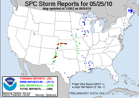
Daily Summary – 25 May 2010

We worked the area of the central High Plains today, with forecasters alternating between the Amarillo, Dodge City, and Pueblo WFOs.  In fact, there were even severe storms in GLD area (the V2 storms) but we didn’t want to keep flipping to new WFOs, looking for more continuity.   We opted to go with a “full-day” IOP (versus 3 hour max), starting the shift by examining the pre-storm GOES-R CI products like in a real WFO environment.  It turns out that the visitors had no problem with the extended IOP, so this began a trend for the remainder of EWP2010 – nearly full-shift real-time IOPs.  At times some of the forecasters would be taken aside for half the shift for the LMA archive case but for the most part, the remainder of EWP2010 operational shifts would be devoted mainly to real-time operations.

GOES-R CI products were once again sparse owing to cirrus, but the overshooting tops product got more of a workout.  The isolated supercell in Baca County provided the best example of the product, giving more confidence to the forecasters in this radar-limited region.  However, the enhanced-V detection algorithm didn’t have much even though the visible satellite data was showing these signatures.  It was surmised that the coarseness of the 4 km IR data git these signatures, an issue that will be rectified by GOES-R’s increase spatial resolution.  More information is reported in GOES-R HWT blog posts here and here.

This was the first time that the forecasters were using he MRMS data in a real-time IOP.  Of particular note was the use of the Reflectivity at -20degC product, which is heavily used via the AWIPS Volume Browser at some WFOs (not using multi-radars, however).  One of our forecasters had a special color map for the product, which added white and then blue and then magenta solid colors at 55, 60, and 65 dBZ, to help identify the 60 dBZ threshold, which is a good rule of thumb for the new 1″ severe hail size criteria.  This was saved as the “CVKING” color map, after its originator, Jim Sieveking (LSX WFO).  It was also found that the MESH was spot on with its size estimates, and the azimuthal shear products were useful for the TOR decisions.

Greg Stumpf (EWP2010 Operations Coordinator)

Tags: None

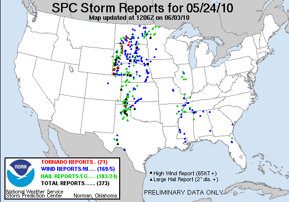
Daily Summary – 24 May 2010

Although there was considerable severe weather today across the High Plains, today was primarily a training and orientation day.  Different from last week, the forecasters received their GOES-R training first, and then did a short IOP to look for convective initiation signals.  After dinner, we picked up with the MRMS training and a “practice” IOP over the Norman area with only one experimental SVR warning issued.

The first taste of GOES-R CI products was had over the DDC and AMA forecast areas.  There was discussion about whether the CI product should be made more liberal in its detections, but the result might be more false alarms.  If the product were probabilistic, that could be viewed completely differently, with corresponding false-alarm rates for corresponding uncertainties.  There is more information posted at the GOES-R HWT Blog.

Greg Stumpf (EWP2010 Operations Coordinator)

Tags: None

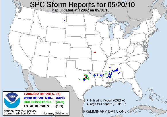
Daily Summary – 20 May 2010

Today we had two IOPs.  The first cenetered on a few tornadic storms in the Fort Wroth (FWD) forecast area.  The second, evening IOP shifted over to the Northern AL/Southern TN Lightning Mapping Array (LMA) area where we could finally evaluate some of the pseudo-GLM data.  The second area ended up with only marginally severe storms, mostly in the southern part of the LMA domain.

The GOES-R activities focused on the PGLM data today, as we finally had an opportunity to look at those data.  There is an excellent write up of the PGLM evaluation on the GOES-R HWT Blog.  In summary, the forecasters liked being able to overlay the PGLM data on reflectivity products to determine where the most likley developing updrafts were embedded in the larger precip areas.  They also compared to the NLDN data, and noted differences between stratiform and convective parts of the precip areas.  We did note that the PGLM data was not being properly sampled in AWIPS to the 8 km grid squares, instead being smoothed.  This issue was fixed on the WDSSII end after today.

The MRMS producers were more heavily used for the FWD portion of today’s activities, and the forecasters continue to express their comfort level rising throughout the week.  Of particular note was that the rotation tracks were really starting to help with the polygon orientation for the tornado warnings.  For the Alabama IOP, the focus was mainly not on the MRMS products alone but in conjunction with the lightning products (see above).  Only one SVR warning was issued for this IOP.

Greg Stumpf (EWP2010 Operations Coordinator)

Tags: None

Daily Summary – 19 May 2010

Activities cenetered on the central Oklahoma High Risk area today, with both teams using a Norman (OUN) localization.  Unfortunately, the OK-LMA network was down, and we were unable to do an analysis of the pseudo-LMA product.   The two teams first sectorized between two supercells north of I-40 ( the westernmost storm being the V2 storm).  Later, as convection developed south of I-40, the sectors were repositioned to be one for the north of I-40 storms, and one for the south of I-40 storms.  All told, our teams issued 71 experimental warnings or severe weather statements today.

For the GOES-R products, one of the main comments from this event is that they all felt the proxy products from the current GOES satellites isn’t doing justice to the expected capabilities of GOES-R with increase temporal and spatial resolution.  For example, there were fewer overshooting top detections that one forecaster would have expected.  The CI products worked a little better today owing to less cirrus obscuration.  There is a lot more information about this in the GOES-R HWT Blog daily summary.

The forecasters are gaining even more familiarity with the MRMS products.  One comments noted that it is nice to be able to look at just one multi-radar product (e.g., 50 dBZ Echo Top) rather than having to figure it out from the many single radars and all-tilts sampling.  Once again, they are discovering that the tracks products (hail and rotation) add a lot of value in determining at a glance both the storm motion (and very stable) and the storm intensity trends.   They also found that the MESH was doing a good job at matching the actual reports, but that the bias-corrected MESH as under-doing the estimates by 1/4-1/2″.

Greg Stumpf (EWP2010 Operations Coordinator)

Tags: None

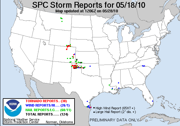
Daily Summary – 18 May 2010

Activities got started off with two teams working two separate WFOs, Pueblo CO, and Amarillo TX.  The Pueblo team had a number of widespread severe storms to deal with, and the Amarillo team primarily had one large tornadic supercell, which also happened to be the VORTEX2 storm.  The V2 storm ended up producing a number of short-lived tornadoes and a lot of damaging hail as it tracked mainly due east across Dumas TX and beyond.
The GOES-R conviction initiation (CI) products were of little use today, owing to cirrus obscuration which tends to inhibit detection of the CI signatures.  In addition, we had a technical AWIPS issue such that the sub-regional scale satellite imagery was localized to Norman (OUN) and not the chosen WFOs, so that only the CONUS scale images could be used, which only update every 30 minutes.  [Note:  This problem ends up getting solved later.] There is more information about this day’s GOES-R activities on the GOES-R HWT Blog daily summary.

The forecasters were also getting their first real taste of using the MRMS products for warnings.  However, we had another AWIPS technical issue that was causing the MRMS grids to load up very slowly (auto-updating was fine).  Because of this, it is possible that the warning results for this, especially those comparing lead time, might be compromised.  [Note:  This problem was partially the result of a faulty network card on the server, and we changed the location of MRMS product storage.  This offered some but not all of the relief.]

Since this was the first day of a real-time IOP for 2010, we’ve learned that not all the wrinkles are ironed out.  We also had some good discussion on warning policies, including whether to issue separate SVRs on the cores of Tornado Warned storms, or to use the TOR to cover both the tornado and severe threats.  In addition, there was some discussion on the varying policies for Severe Weather Statement (SVS) issuance per WFO and per region.  The differences were interesting, and there is not a single policy NWS-wide.

Greg Stumpf (EWP2010 Operations Coordinator)

Tags: None

Daily Summary – 17 May 2010

Most of Monday 17 May 2010 was spent on training and familiarization of the new products.  A practice IOP was conducted for one hour for the Midland/Odessa, TX (MAF) forecast office, and one practice warning was issued.

Greg Stumpf (EWP2010 Operations Coordinator)

Tags: None

Summary – 10 June 2009

Teams are wrapping up their respective archive cases.  Dan N. and Steve worked the 10 February 2009 CASA case and Gail and Bill worked the 30 April 2009 PAR case.

We will wrap up the day with surveys and discussions.

Kevin Manross (EWP Weekly Coordinator, 8-12 June 2009)

Tags: None

Summary – 9 June 2009

Wrapping up ops for the night.  Steve and Bill switched from DDC to TSA.  Steve experienced considerable trouble with his AWIPS workstation, and it appears to be a problem overlaying the environmental data on the the elevation scan.

Dan and Gail stayed with ICT.

(UpperLeft KICT "All Tilts" REF showing 50 dBZ at 42 Kft) (Lower Left MRMS 50_EchoTop Product indicating 26 Kft)
(UpperLeft KICT

We missed the possible tornado east of DDC.  Comments will follow in tomorrow’s debried.

Kevin Manross (EWP Weekly Coordinator, 8-12 June 2009)

Tags: None

Summary – 8 June 2009

Greg is stepping through the replay of tonight’s event comparing the HWT warnings with the NWS warnings.

First impressions with MRMS from the forecasters:

Bill – took a while to get used to MRMS data

All- liked the trending info

Daniel N. – interested in combining base data with MRMS data in a 4-panel.  Also found track info helpful in polygon issuance

Steve – MRMS data helpful particularly when storms went near/over radar.  Expressed concern about the difference between MRMS “X above Y” compared to single radar data and model soundings.  Found Rotationtracks quite usedul.

Discussion – usefulness of “X above Y” products when dual-pol comes along.  Will these become obsolete?  All agreed that this would be very useful in reanalysis

Kevin Manross (EWP Weekly Coordinator, 8-12 June 2009)

Tags: None