Rotation Tracks in a QLCS

In today’s case, MRMS rotation tracks did a better job at showing where the most likely tornadic storms were in a QLCS compared to the 0-2 km merged AzShear, at least over the entire period which makes sense. I would never warn just based on rotation tracks, but I couldn’t find a better SA tool today. It was easy to step back in after working way too long on a previous blog post and get an idea of what happened while I was away. I still feel like the single-radar AzShear would have been extremely useful with today’s QLCS.

Alignment is Everything

Another advantage of single radar AzShear – orientation to the radar.

Here is an ongoing tornado (according to the report shapefile from this event) as seen in the merged 0-2km AzShear product:

Yeah, likely TVS in the velocity data from KEOX (top right pane), Reflectivity is…messy…, and Merged AzShear shows an area of white (when sampled showed 0.023 s-1 values) associated with the TVS.  That is pretty strong!

However, the Merged product loses some key information that could come in handy in figuring out details of the vortex; how is this oriented with respect to the radar?  This is where the single-radar AzShear comes in handy:

Each single-radar (KEOX top image, KMXX bottom image) now shows much better information on how the area of shear is oriented with respect to the radar.  This becomes essential in situations where there are multiple areas of strong AzShear in and around a possible tornado; things like a new circulation in the flanking line that could eventually merge with the original tornado, mesocyclone occlusion with new development, weakening tornado rotating back into the core of the storm, anticyclonic tornado development, and so on.  Many of these features may be lost in the merged products but will stand out to the discerning eye on the single-radar products.  Add in the fact that these update scan-by-scan and during quickly evolving features in critical periods of the life cycle of small-scale vorticies, and single-radar becomes pretty valuable.

Have I mentioned yet that I would like this in my office? Now?  Please…

-Dusty

QLCS spinup detected by low-level AzShear

QLCS situation just outside of the HGX CWA where low-level combined AzShear spotted two areas of increased low-level shear entering Robertson County. The northern circulation eventually led to  downed trees east of Calvert 12 minutes later, and may have been a tornado, according to the LSR. This product would have given me more confidence to at least have a severe thunderstorm warning out, if not a tornado warning, and would most likely have led to a greater amount of lead time than I would have had otherwise.

ZDR_Arcophile

Would YOU issue a convective warning based solely off Single-Radar Az Shear data? 

What if you’re on shift and convection has become more widespread or robust than what was currently forecast? What if that happened during a time where staffing levels at the office were not ideal (for whatever reason)?

-Convection is rapidly developing.
-Minimal people around to sectorize radar/warning operations
– Limited time to interrogate all the storms, especially with a potentially tornadic situation developing.

Taking a look at Single-Radar AzShear, there are very high values near a velocity couplet north of the radar site. This couplet becomes your primary area of concern to where you want to focus most of your attention and analysis. However, there is also some bowing in the reflectivity signature coincident with some bowing/enhancement in the Single-Radar Az Shear output well to the northeast of the radar site. The angle of the radar beam with the bowing storm makes you question the strength of the storm and you realize the velocity values may be too low.

Would you consider issuing a SVR based solely on the enhanced bowing segment of the Single-Radar AzShear data, so that you can focus your attention on the tornadic storm? Something to think about…

Correlation between Single-Radar Az Shear and a TDS?

A tornadic debris signature was noted during this event with a loop (not shown) of low CC values, with depth,  coinciding with a strong velocity couplet and high Single-Radar AzShear values. Is there any correlation to a TDS signature with Single-Radar AzShear values? To be determined…

Place marker denotes the TDS location in this image.

AzShear: One feature, three views = increasing confidence

As we move along through this case, east of the convective line exists a plethora of potentially potent supercells; each is producing high values of AzShear from multiple radars as well as in the merged products.  But what about further back west with the incoming convective line that is looking a little QLCS-ish?  Here is an example of how three products can be used together to help determine areas of increasing potential for rotation.
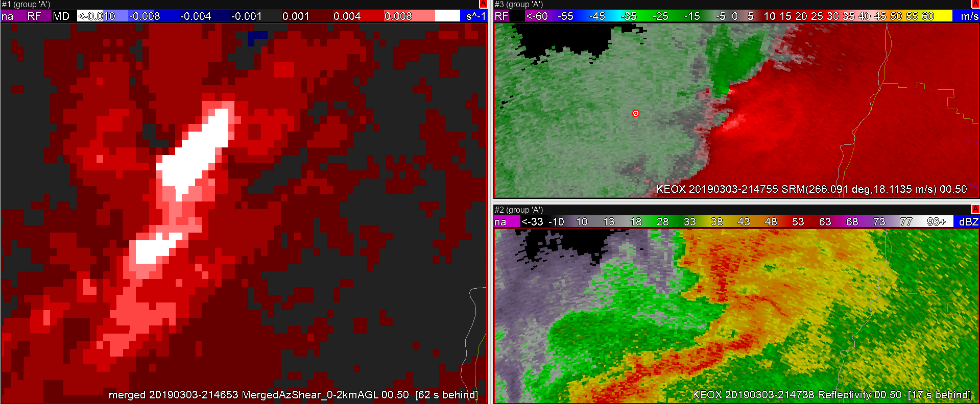
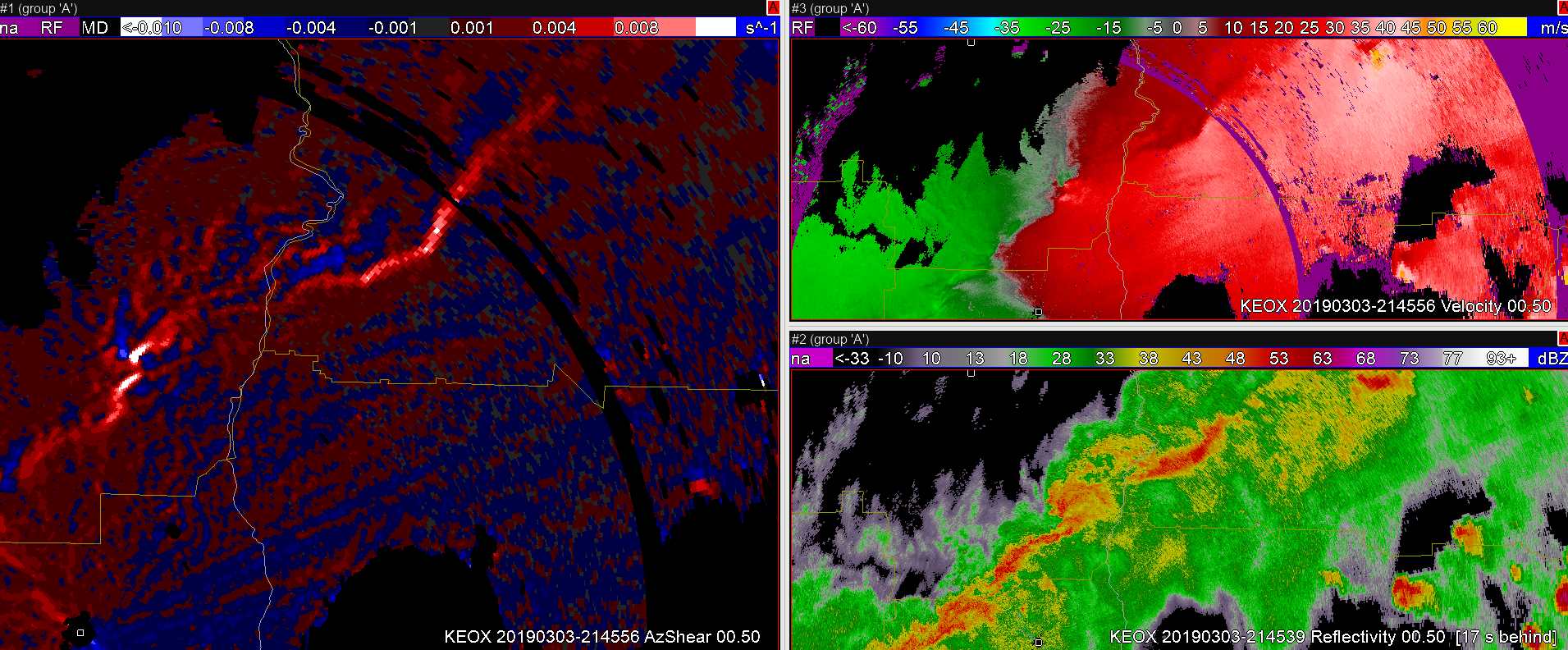
First, from KEOX:

A broken line of storms has an area of enhanced inbound velocities with a stronger storm in the line (just south and east of the target/bulls-eye/red and white marker).  The single-radar AzShear shows cyclonic shear all along the leading edge of the line but with an enhanced area of shear along a small bowing segment.

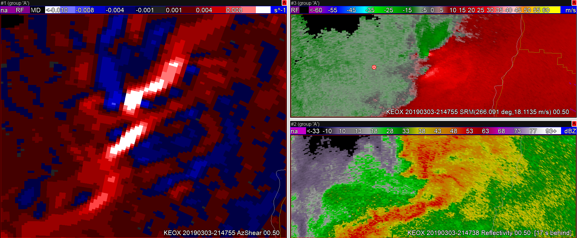
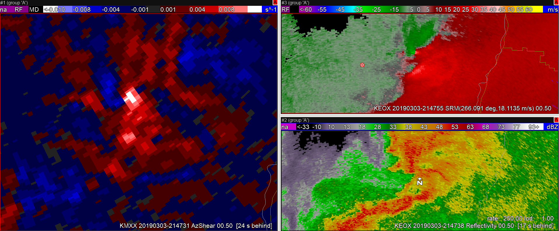
Now take a look at KMXX AzShear (with the velocity and reflectivity staying with KEOX):

Only 1 minute 30 seconds after the KEOX scan, this shows what will likely be an area of rotation higher up in the storm (2.5 km up from KMXX vs 1.2 km up from KEOX using the beam sampling tool) so there is something aloft as well.  O.K….thinking along the lines of mid-level rotation above a strengthening area of shear at the lowest tilt; interesting.

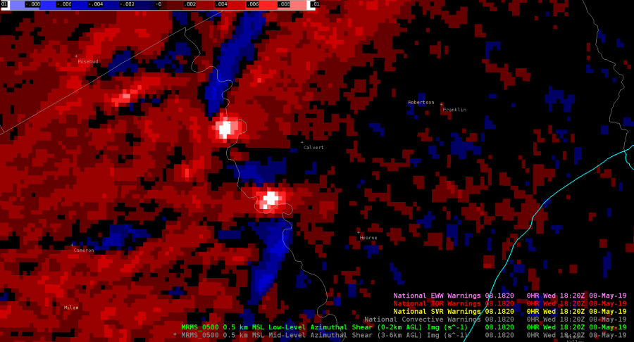
Finally, looking at the merged 0-2km AzShear (again with the velocity and reflectivity products remaining at KEOX):

Yup, there could be something there BUT the big caveat is that you don’t want to get caught thinking that this feature has a long “history” since that trail extends south and west from our area of interest.  Nope, that’s the shear along the leading edge of the convective line.  However, it does show that the strongest AzShear values are close to our marker/area of interest so id doe need to be watched for future potential strengthening…(post-note: nothing was reported/observed tornado track wise)

-Dusty

Even Better Example where Merged AzShear can be more beneficial than Single-Radar AZ Shear

Let’s say your storm’s velocity data crosses into the dreaded “purple haze”. This  loss of velocity data also results in a loss of single-radar Az Shear data. So, what do you do if you’re on the warning desk? Do you scream and panic? No, that wouldn’t be ideal. Rather, take a look at the Merged-shear products. In this example, a strong storm moved into the “purple haze” of KMXX’s radar, thus losing reliable velocity and single-radar AZ Shear data. However, surrounding area radars are still getting a good reading on the storm, and thus the operational forecaster can utilize the Merged Shear products to calm their nerves as to whether the storm is still worthy of maintaining focus on it.


Example where Merged AzShear can be more beneficial than Single-Radar AZ Shear.

What happens if convection moves far enough from your radar to where the single-radar Az Shear becomes less reliable? The Merged shear products can then potentially be useful! In this example, the storms have moved to the edge of the useful range of the KMXX radar. The KMXX single-radar Az Shear (top right) values are much weaker/potentially less reliable and the KMXX velocity data (bottom right) also leads to uncertainty as to how much attention should still be given to the ongoing convection. Utilizing the Merged shear products (left) indicates that the convection is likely still strong (at a minimum) and warrants further investigation.

Single vs. Merged; +/- For Each

Almost an hour into this replay of an archived case and some thoughts on the Single Site AzShear using this image as an example.

I can count at least 8 areas that AzShear shows potential areas of rotation that need a closer look.  Advantage.  The rapid update every volume scan means there isn’t a wait for the 2-minute Merged AzShear products to arrive.  Advantage.  However, there is a lot of noise, especially along the leading edge of the gust front/line of storms to the southwest of the KMMX radar site.  Not shown is the single-radar AzShear from KEOX which is not as noisy but is also looking at the mid-level of the storms.  Disadvantage.  The strength of the AzShear signatures depends on which radar you are looking from and the orientation to the beam.  Disadvantage.  Features are range-dependent so if you are looking for a low-level feature from a distant radar without a radar closer to the area of interest; Disadvantage.

So, how may the Merged AzShear products come into play?  We’ll use this as an example (which is taken from the same time and space as the image above):

The first thing to notice is that there is much less noise; the merged product has a lot of the small +/- AzShear values around the KMXX radar site removed but still holds on to the stronger areas that may need closer inspection.  Advantage.  For the line southwest of KMXX, northwest of KEOX, again, many of the less interesting/noisy features are reduced leaving the areas of stronger shear in for closer inspection.  Advantage.  However, the biggest disadvantage is the time-lag; since the merged AzShear products arrive every 2 minutes, any quickly intensifying areas of rotation can be missed.  The merged product also has trail of where the strongest AzShear values are which can be used for tracking purposes; Netural.

As it stand right now, I’d say that I like the single-radar AzShear for storm interrogation purposes since it arrives nearly real-time with every scan.  It is also useful because it gives me the base information that gets fed into the merged products which then goes into the MRMS Rotation Track.  I’m a big fan of knowing what is going on “behind the curtain” and the single radar AzShear product gives me that information.

-Dusty