Thursday – Morning Case

I noticed when putting out my initial tornado warning, that TORP was highlighting a circulation slightly southwest of the more apparent circulation. Not sure if this is due to some setting I had toggled on, but I was a bit shocked to see that TORP did not highlight an area of very strong rotation.

Throughout this case, I did notice that divshear did a phenomenal job at detecting and highlighting circulations off shore. There were several times that I was made aware of a circulation from both the Az and Div Shear products before velocity.

There was one instance where Az and Div Shear swayed my warning decision. The above image shows that in reflectivity, a beam blockage kept imagery relatively weak. However, the Az and Div shear products are highlighting an area offshore. Because I saw this, I was inclined to investigate my SRM product, which showed strong rotation. I found this to be a very useful instance of the tools working to influence decision making.


-Fujitareno

AzShear/DivShear and TORP handling a cycling supercell

I was impressed to see the evolution of AzShear and DivShear during a supercell cycling mesos. The classic AzShear dipole and DivShear clover appearance are evident to start, along with notable convergence along the leading edge of the rear flank gust front just beyond the clover. As the cycling occurs, two distinct dipoles form in AzShear, with the new one strengthening and the old one weakening. Meanwhile, the clover look in DivShear became less organized as it attempted to resolve two nearby circulations. While this process can be observed in base velocity, that may not always be the case and AzShear/DivShear proved helpful in visualizing this occurring.

TORP probabilities dropped a bit quicker than I would like to see as the cycle occurred. I don’t know if it struggled with tracking given the two nearby circulations both changing in intensity (in opposite ways – one decaying and one strengthening). In this case both weakened so the lowering probabilities were alright, but often a tornado could still be ongoing underneath the decaying meso (or rapidly spinning up under the new meso) so I would prefer to see at least medium probabilities continue a bit longer until the cycle is complete.

– Mr. Peanut

5/9/2024 Bill Lumbergh Morning Case

I am from an inland office, so my marine experience is limited. But based on a few couplets with persistent TORP probs, went for a warning. The TORP probs helped draw my eyes to problematic areas.

AzShear and DivShear did well with the circulations out over the water. It even did well where the radar power was greatly reduced

TORP probs have been oscillating quite a bit, which hinders confidence some. However, the first few cases of the experiment TORP was more steady. Maybe these oscillations are actually more common, and the steady probabilities for Days 1 and 2 of the H.W.T. were not the normal performance of TROP?

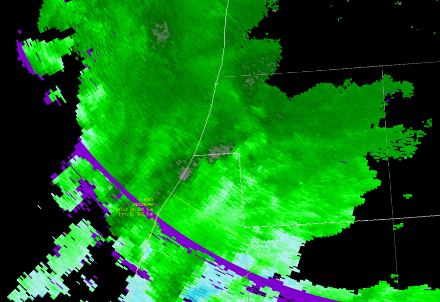
The SRM Vrot didn’t look that great, but the combination of higher TORP probabilities along with persistent mid-level meso led me to reissue a tornado warning at 0843z near Little River, SC. The TORP and AzShear help to augment this decision.  (see image below)

TORP continues to be useful for Special Marine Warning and waterspout conditions. Keep in mind, it doesn’t take as much to create problems over water than it does for land, so it is easier to have confidence. In addition, you don’t need to have a waterspout to create problems for marine, so having the marine warning out won’t result in false alarm problems like they can on land. AzShear and DivShear imagery seems to help “explain” TORP output as well. (image below).

I find it interesting that in this area of Z dropout from the tree blockage, TORP tends to increase and makes sense with the velocity data. I wonder what would happen if you removed Z and ZDR from the algorithm and only used Velocity, Sprectrum Width, and CC, and maybe KDP in the TORP learning.

This case has had the most persistent TORP probabilities above 80%. Is there something about tropical cyclones or environments that help to drive this and allow the algorithm to have higher confidence?

Here on Day 4, subjectively, this has been the most robust performance of AzShear and DivShear. Today, AzShear/DivShear signals and TORP trends have been very consistent. For example, the first storms that produce tornadoes and waterspouts had TORP with 50% or greater and had enhanced Az/Div Shear values. Subsequent tornadoes/waterspouts had very similar values. This repeat in values in the same environment helped to drastically increased confidence in these fields. These provided similar lead time to the development of notable Vrot in the V/SRM fields. Operational forecasters love persistence. And through 0938z, we have had that with the TORP and Az/Div Shear parameters.

Example below of how AzShear and TORP produced higher values, similar to previous storms, and storms behaved in the same way. This persistence increased confidence.

The increase in AzShear and TORP probs resulted in the warning issuance of at 0954z from Lumbergh. The vrot increased after the enhanced Azshear and TORP. Again, persistent behavior increasing confidence!  (image below)

One thing to note, is that I am not a tropical forecast office meteorologist. I have some Great Lakes experience. Therefore, my mental conceptual model of tropical cyclone tornadoes and supercells is limited, which at first may have hindered my ability to “calibrate” TORP to what I was seeing on base products and dual-pol. However, persistent signals are a forecaster’s best friend. But I do think it is important for meteorologists using these algorithms to have a conceptual model. If you don’t apply critical thinking to these, you will be chasing after a lot of false alarms.  These tools are very fascinating. But they take time to learn. The NWS currently has a paradigm where 4,000+ meteorologists are to have a baseline training in severe storms radar interrogation, as well as forecasting, hydrology, and Impact-based Decision Support Services. My fear is that if these tools (e.g. AzShear, DivShear, TORP) were to be deployed, it may get negative feedback despite positive feedback in HWT and OPG experiments prior to deployment. I feel that NSSL and the greater research community really needs to advocate for putting this work in the hands of dedicates subject matter experts in an operational environment. I think advocating for this will aid in expediting the advancement of these tools.

Thursday Tropical Case

I find myself often lowering object filter to 0% to see every object. I can quickly flip through and triage this way, and also the higher probability show up as thicker circles anyway.
-dryadiabat


Using prob trend graphics to see upward trend in rotation. Going for lead time with the Tornado Warning based on persistence and trends.

-dryadiabat


Watching an area of deeper rotation immediately east of the radar site that does not currently have a TORP object. I was surprised to see it does not, even with object filtering at 0%.


-dryadiabat

UPDATE: It appeared with a history trend, but was absent from the display for a total of 11 minutes in PHI.


Explored the direction trend option and saw small changes. I thought this would be a good case to test its usefulness since storms weren’t deviant but changed path gradually with time given the larger scale circulation. If the degree range were narrowed, this would stand out more. Just a suggestion.


-dryadiabat

Sidelobe, Confirmed TOR, & Product Responses

This storm started with what appears to be side lobe  contamination. TORP did identify this feature and put out low probabilities. I can see this as a positive since it does keep probabilities relatively low for sidelobe. Curious to see how it would react if the sidelobe contamination appeared stronger?

As the storm progressed, a well defined meso formed over southern Michigan. TORP recognized this relatively quickly and began putting out 70-80% probabilities.

A CC drop was noted at 2119Z for this storm. Here is the Az and Div shear values at that time. Overall, not a great response for a confirmed tornado.

-FujitaReno

Bill Lumbergh — 5/7/2024 Afternoon Live

Starting off as WFO IWX

Az Shear steadily increased in Berrien County, Michigan around 2010z but did not get a TORP object. Increasing AzShear in close vicinity to the warm front prompted the SVR issuance.

Interesting how “nothing” convection over the lake gets the TORP probs, but the supercell in Berrien County with strong AzShear does not. (see below)

Example below of ground clutter high V values giving bad AzShear and DivShear data

One side note: Noticed it is harder to look for SVR wind and hail because TOPR, AzShear, and DivShear has me looking at the tornado threat more than anything else. Wondering, if products like this in future go operational, if you need to seperate tornado warning operator from a wind/hail one for the work load…

Below, TORP went way up to 57% as this got close to the warm front, div shear went up. Still waiting to see how Az Shear responds, and then SRM for Vrot

AzShear goes up, crosses the warm front, start to see Vrot organize, TORP comes in at 57%, tornado warning issued.

Storm fell apart, looks like cold pool ejected from forward flank, SRM never tightened up with respect to Vrot, TORP probs also dropped


Still no confirmed no tornado. Looked like it was dying, then took a right turn. GRR TORP remained high as the 0.5 deg scan was getting the persistent mid-level meso. IWX radar was up and down as the 0.5 low-level meso was “sloppy”. However, a right turn and potential cell merger with GRR TORP still high, decided to reissued downstream with a tornado warning.

LOT/GRR Real Time Case

KIWX has spurious outbounds behind the higher reflectivity that do not appear to be associated with organized storm-scale rotation, given it’s placement and also very high spectrum width. 33% prob TORP seems to be associated with this artifact. 


-dryadiabat


Noticed that two TORPs along the leading edge of the line jumped to a common circulation but did not merge. One was from KMKX and the other was from KLOT. Ideally, these would have merged and the TORP from the closest range radar would have taken over.

UPDATE: Found “Display Overlapping Options” filtering option, which when turned off shows objects from all radars. Curious how this filtering decides which to display when turned on? Higher probability? Closer range? Longest track duration?

-dryadiabat


Although insignificant and not worthy of a Tornado Warning at this time, it’s noteworthy that TORP did call my attention to an area of a storm cluster where I would not have heavily interrogated the velocity. Rotation is weak but is present and TORP flagged this, calling my attention to it. This demonstrates at the very least the situational awareness utility of TORP.  Noticed this in AvShear, too.

-dryadiabat


The difference in the rotation between KGRR and KIWX doesn’t seem to necessitate that difference in probabilities for the objects associated with each radar. 48% vs 90%. Upon going back to look at this again, I only see GRR and not IWX. So filtering must have purged IWX, although in real time they were both visible. 

Tuesday Practice Case

A sudden yet steady increase in DivShear helped lead to an earlier lead time on a tornado warning when rotation in velocity was apparent but still generally weak.

AzShear was medium leading up to the tornado reports and only jumped up after reports started coming in around 12:20z.

Spectrum width, which I would generally rely more on in the absence of these new tools, had a general positive trend through this period, but plateaued in the minutes leading up to the tornado reports.

The absolute maximum of velocity trend was low leading up to the tornado reports and only suddenly increase afterwords. Essentially, just relying on strong rotational velocities in this case would have resulted in no lead time for the initial reports.

TORP, while sometimes slow to update in AWIPS compared to the online tool, helped highlight an area of weak vrot where a tornado was likely ongoing based on storm reports at the time. (If not a tornado, there were at least several TSTM WND DMG reports.

While TORP only remained around 50%, both AvShear and DivShear highlighted an area of strengthening rotation that may have been associated with a brief tornado, including a clover pattern present in the DivShear. Neither of these features prompted a tornado warning, but confirmed suspicions immediately after the warning was issued based on the velocity pattern.

TORP does a good job tracking QLCS meso and possible tornado

TORP does a good job here of identifying a developing QLCS meso and tracks it well as it gradually tightens, with a TORP max of 56% occurring at the time the circulation is strongest and a tornado possibly occurring. TORP was a high as 50% several scans before the circulation was strongest, which could have been an indication that it was an object to keep an eye on, though probabilities drop to <30% for the following two scans before the  eventual spike to 56% and possible tornado.

The object in question is the southernmost one that begins east of Heflin and tracks through Dumfries.

– Mr. Peanut

Another example of AzShear and TORP being good situational awareness tools

Just wanted to show a case of weak rotation that TORP and AzShear handled well. This was also in a broken line, which I have seen TORP struggle in. Not sure why it handled this situation as well as it did.

Here you can see how this weak rotation in velocity can be overlooked at first if there is a lot going on on radar. You can also see though how there is  a TORP object and it has been tracking it for a bit, all while the rotation is very weak:

Here is AzShear at the same time:

As you can see it may get your attention more than the velocity signature would.


Now stepping forward in time, you can see a better couplet in velocity along with a bright AzShear signature and a clover signature in DivShear. This is when we decided to warn. Probably would have warned with just seeing the velocity signature, but AzShear, DivShear and TORP definitely helped nudge us and get the warning out quicker.


-Gary