Monday, May 13th Montana Storms, downburst/hail potential

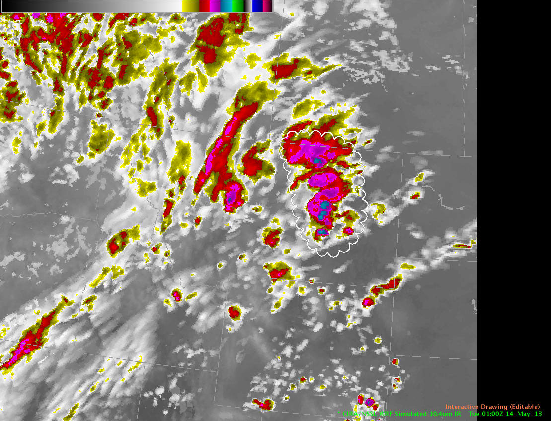
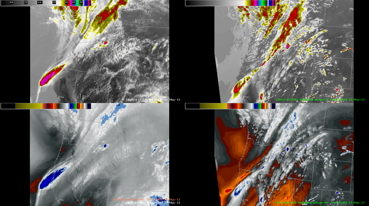
Location: Montana. Threat: severe hail/high winds. Soundings suggest potential for thermodynamically-driven downbursts over mountainous terrain. Question: will cloudtop cooling (CTC) rate be applicable to hail cores that could generate wet/dry microbursts?

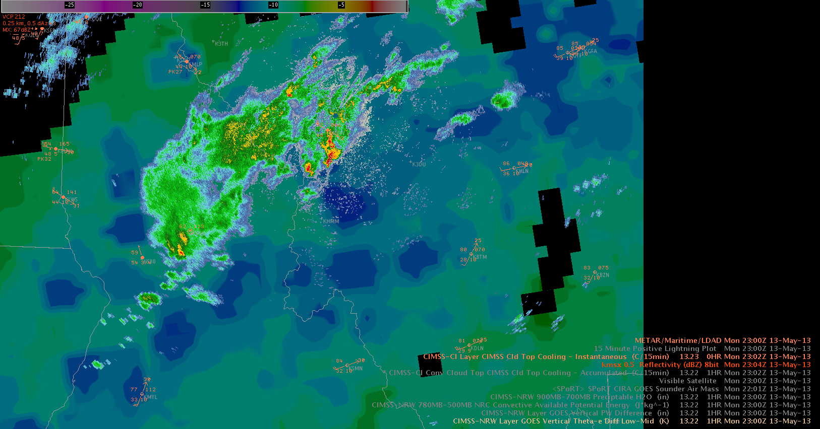
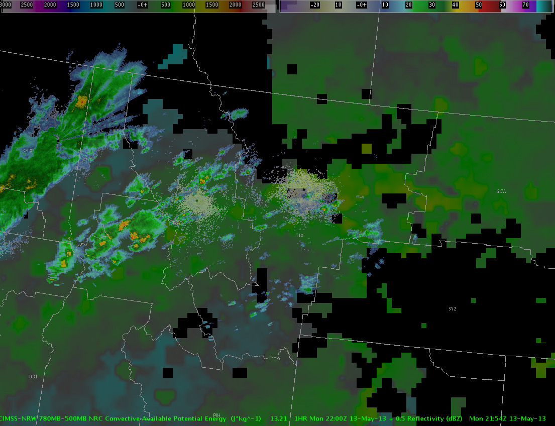
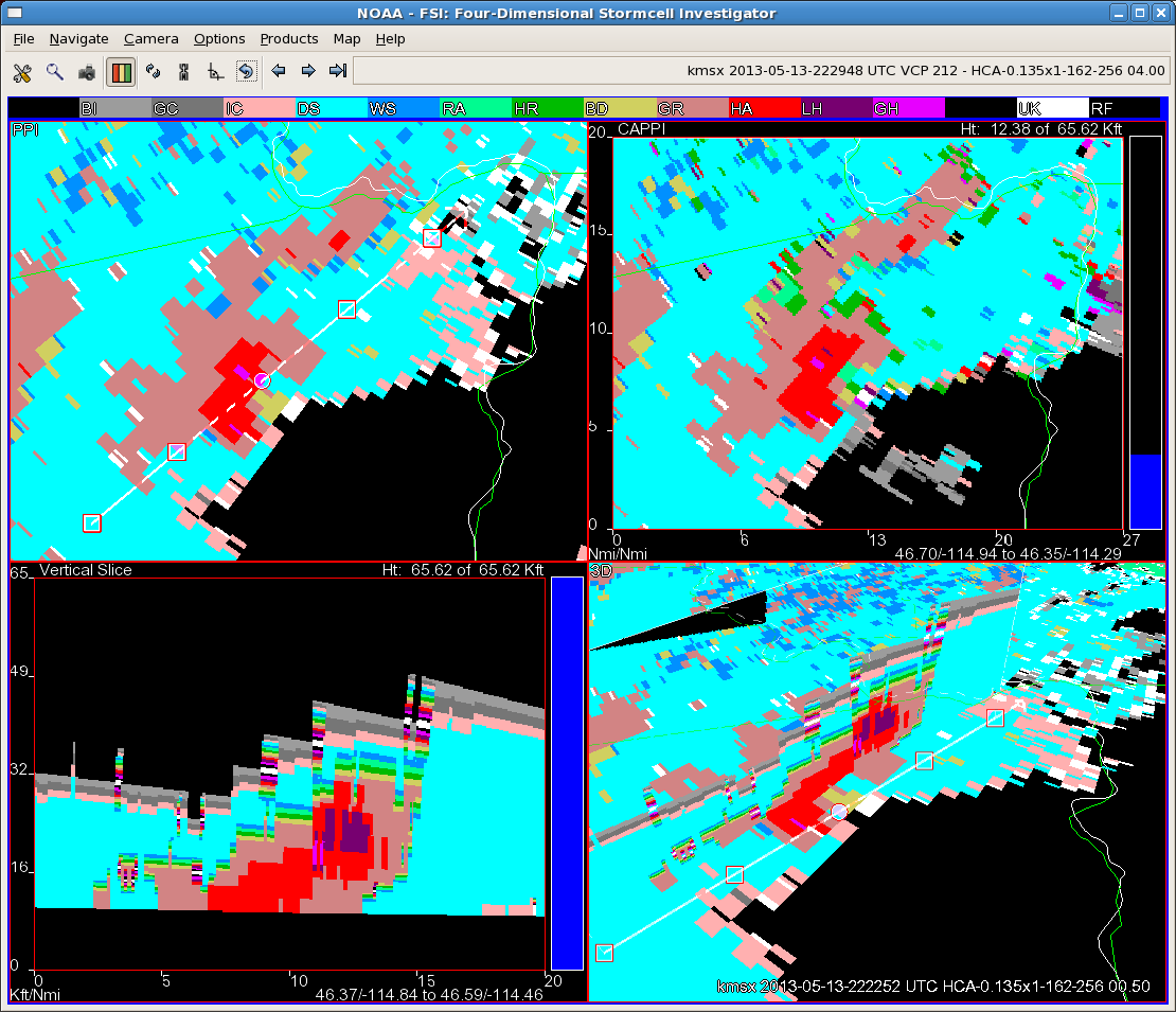
CTC rates have been noted to have problems in mountainous regions such as the Rockies and even Appalachians. The rates were at or below 10C/15 minutes on the first few updrafts and only one storm briefly (one volume scan) reached 50 dbz through 20UTC. A storm entering Idaho County showed cooling rates of 12.6C/15 minutes at 2015 UTC, but this storm did not intensify until after 2130 UTC. This storm was not assigned a CTC rate after 2015 UTC because of masking by cirrus blowoff. Another storm that formed on the forward flank of this storm became marginally severe but was also never identified due to cirrus.

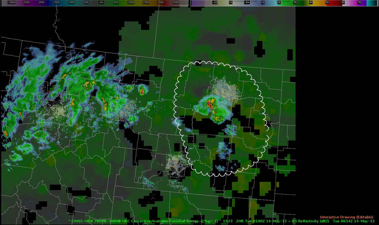
Possible sampling issues were noted in the MRMS sfc height of 60 dbz above -20C. The levels showed big scan to scan variability which may have been a function of distance from KMSO and sparse coverage of surrounding radars. As this storm got closer to the RDA, the scan to scan variability decreased.

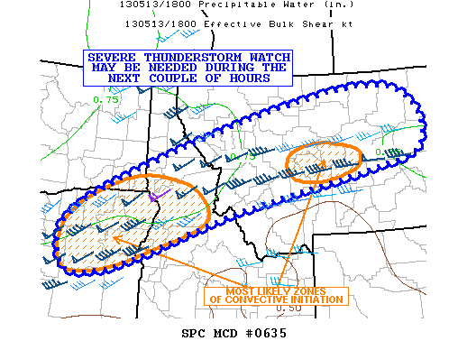
SPC issued a severe thunderstorm watch at 21UTC with the main threats being large hail and high winds, with a secondary threat of a tornado.

– Ostuno

Tags: None

14May2013 01Z Mesoscale Discussion Update

Best possibility for near-severe wind gusts and marginally severe hail appears to exist across the E half of Montana over next couple of hours. WRF simulated IR images and CIMSS 780-500mb difference products continue to point at this region having the best thermodynamic environment (approx 700-900 J/kg of CAPE) to maintain convective development during this time period. Regardless, severe threat still appears to be low-end.

0100zsimIR nrwcape_radar

Picca

Tags: None

CIMSS vertical theta-e difference product with ongoing strong to severe storms

refl_theta-e_diff_13_05_2330Z

Despite moving atop an increasingly dry boundary layer (ref. to dewpoint readings in the mid to upper thirties), the strong to severe thunderstorms keep their strength. The GOES vertical theta-e difference (low-mid) product highlights the moist and unstable air mass nicely with 500-1000 J/kg (another product) present. In fact the thunderstorms really increased in strength when approaching and eventually crossing that plume of unstable air. For this event, the product by CIMMS helped a lot to get a feeling about how supportive the air mass stratification would be ahead of the thunderstorm despite decreasing boundary layer moisture. In the near future we should see a potential increase of a downburst risk with inverted-V profiles to the E/SE of the storm. A marginal hail risk continues with that storm.   Helge

Tags: None

Simulated IR Satellite Comparison Across NW US

IRCIMASSimulatedIR051313Comparing the simulated satellite from NSSL-WRF/GOESR/CIRA on the right to the actual IR on the left at 23 UTC on May 12 depicts general good agreement.  The simulated satellite imagery overdeveloped isolated convection over southern Idaho, Montana, and Wyoming, and was a bit to quick/far to the east with the cooler/deeper moisture plume from far northern California to Alberta.  The simulated IR verified very well with post-frontal cold air cumulus depiction over western Washington and northwest Oregon. Michael Scotten

Tags: None

13May2013 2245Z Mesoscale Discussion for Developing Convection in Northern Rockies

A shortwave trough is moving through central Washington and Oregon with scattered coverage of storms initiating over northeast Oregon and the Idaho panhandle this afternoon.

wv300mb

CIMSS Nearcast Product is depicting a weakly unstable environment averaging 500 to 1000 J/KG along a corridor stretching from eastern Oregon through northern Montana with storms initiating off the higher terrain and continuing to track along the axis of instability within this corridor. RAP analysis is indicating roughly 60 to 70 kts of 0-6km shear collocated with axis of instability…which is likely inhibiting deep growth and organization at this time due to the imbalance of high shear and weak instability.

nrwcape_mosaic 0_6shearbarbs Initial look at synthetic WRF IR and WV show relatively good agreement with GOES IR/WV…albeit slightly more progressive by about 50 to 100 mi. Strongest storm so far was analyzed quite well by the WRF in northeast Oregon with only a slight southern displacement from real time location. In general though…the model captured the initiation and future trend of this storm with relatively high accuracy. Additionally…the model is showing future intensification further east off the higher terrain through the evening…although the slightly more progressive system in the model may mean a later initiation and intensification of this activity by an hour or two.

13May21ZsyntheticComp

However…once the convection does initiate…slightly less shear collocated with an area of 1000J/kg could allow the storms to become better organized than current trends. The synthetic imagery portrays this situation across western and central Montana 23Z through 01Z. Current surface observations show a relatively dry boundary layer in this area with dew points averaging in the low 40s and downslope winds.  Main threat from any storms in this region will be mainly downbursts but better storm organization will allow for a continued severe hail threat as well.

Mazur/Picca

Tags: None

An opportunity to examine the new HSDA

Finally have a storm with decent returns aloft that gives us a chance to investigate the new HSDA (Hail Size Discrimination Algorithm).  The image is a four panel from FSI.  Note the bottom left panel showing a cross section of the storm.  The red color is the usual dual-pol rain/hail mix signature.  The purple between 20 and 25 thousand feet is one of the new hail levels…in this case, indicating “large” (between 1 and 2 inch diameter) hail.  Of course, with the warm and dry surface layer across much of the area, this hail would likely have a hard time surviving to the surface.  We’ll see if we get any hail reports from this storm, but from what I saw to this point, I would be hard pressed to warn on this storm…perhaps an SPS for non-severe hail would be in order.

CL

FSI_HCA_051313_2230

Tags: None

Cld top cooling product and cirrus clouds

We’re monitoring a few showers/weakly electrified storms over N-central Idaho. Using the cloud top cooling product, the focus for cooling was found to be along the northeastern fringe of that cluster. Using VIS imagery and keeping strong SW-erly shear in mind, the northeastward blowing cirrus shield (increasing in strength due to strengthening convective activity) caused the strongest signals for cooling (e.g. -20K/15min) along the NE fringe of that cluster. However, the most healthy looking cells eventually evolved just to the south of the cirrus shield, where some clearing occurred. It seems like this “messy situation” with rapidly clustering storms may mask local areas with better conditions for initiation.Cld_top_cooling_13_05_13_22ZReflectivity data beneath the cloud top cooling product.

Tags: None

One indication of how goofy this year has been weather wise…using GOES-R CI

Not expecting a gangbusters severe day.  The only area of real risk is across ID/MT today.  We are starting out in the Missoula CWA and I have been checking out the GOES-R SATCAST CI product.  There have been some weak cells already showing some modest CTC signals…that one in the upper right panel is around -10C/15 min.  The SATCAST product in the upper left has shown plenty of weak CI signals and a few stronger ones.  Of particular note are all the pink areas on the SATCAST product.  Those are “snow contaminated” areas…particularly widespread for this time of year!  I find it neat that one can use the SATCAST in concert with the visible image to discern the real signals from the snowy noise.  Continuing to wait for interesting storms.

CLCI_051313_2014

Tags: None

EWP Week 2 underway

Forecasters have begun operations, localized as the Missoula, MT County Warning Area.  Todays initial focus is familiarization with AWIPS2 and the experimental products (where to load, new procedures, etc).

Surface temperatures are reaching the low-to-mid 80s across MT, with a bit of downslope flow on the southern end continuing to dry out the region.  A few small storms / showers have begun to form in NE Oregon and across central Idaho. Expectation is for these to expand in area and strength (marginally severe) across the late afternoon and evening. Once storms form, they are expected to move E-NE.  Hail and winds are the primary concern today.

SPC mesoscale discussion graphic for 2pm CDT on 13 May 2012


K. Calhoun (EWP Week 2, coordinator)

Tags: None