17 May 2011 AFD

Convection ongoing across Carolinas into Virginia this morning, and convection is expected to continue and intensify this afternoon given some clearing in warm sector and minimal cap. Nearly saturated environment, low-cape/moderate shear environment will result in strong and possibly severe storms. Although damaging wind gusts will be primary concern, low-lcl environment will keep threat of brief/weak tornadoes with initial development of convection primarily over eastern Virginia into eastern North Carolina where low-level cape/stretching potential will exist. Warm front extending sw-ne across northern portions of Virginia will need to be monitored as well with conentrated low-level shear. CI satellite detection possible early in the event before cirrus canopy becomes an issue. Hi-res models forecast banded convection near cold core and initiation of bands with CI detection may prove useful where higher impact areas will evolve. Already some more obvious clusters of CI detection using UAH product are highlighting areas in srn VA/nrn NC where new 12Z SPC 4km WRF is fcstg clusters of convection near short wave to develop early afternoon. CI products may continue to be useful to help identify where these potential severe clusters/bands may develop within the wider scattered shallower convection expected to develop. Value of 3dvar may prove useful as well where low-level vort and updraft fields can help warning forecasters concentrate on regions where low-level cape/shear are maximized. Good opportunity to experiment with utility of many 3DVAR products with shallower convection.  Same with MRMS products. In addition, some  of the nearcast differential theta-e/PW products indicating severe potential through mid to late afternoon over central VA shifting NW into northwestern VA…consistent with local WRFs and SPC WRF ideas.

High plains convection will be possible near developing dryline across eastern Colorado/western Kansas. CI detection will be useful late this afternoon and early this evening as it may take a while for CI once cu develops. Although shear will be increasing through the day, moisture availability will be a concern for more than LP type supercells, especially as storm move off of higher terrain.

Warning ops – our feeling is that initial warning ops, perhaps through at least 21z, should be centered on mid-atlantic region with the option of shifting west to Colorado eastern plains and western Kansas after 21z for possible initiation of isolated/scattered supercells. Greatest value of satellite CI detection and 3dvar fields may be most useful over eastern ops area, although CI detection along with OUN WRF output could be utilized out west. Expecting mainly a hail threat with the LP-type storms in the Plains, and evaluation of some of the MRMS products would be helpful as well.

Tags: None

Wrapping Up

Forecasters are finishing their surveys on the DRT case.  When they are done, we will spend some time discussing their first look at the products and have some Q&A.  Comments folow…

Thoughts on training vs DRT case:

Steve – Would like to have more background but also have the chance for an in-depth look, but given the time time constraints this worked.  Essentially,  would like more time for background AND data analysis.

Kevin D – will now look back at the handbook after having some idea of the usable values.

Kevin B. – procedures preset would have been very helpful to jump into the analysis more quickly.

Bill – more of a chance to see relationship between base data and experimental.

Jessica – would like to have seen something other than a slam dunk case.

Initial thoughts on using experimental data for the first time:

Kevin B – “misplaced” downdraft max to SE of storm E of Henessey (2216 Z).  Illustrates confusion of the max/min composite W can have to operational forecaster.  If we were able to browse levels, this might be a bit easier to use/grasp.  We may try using WDSSII a bit more to illustrate this.

-K.Manross Week 2 EWP Weekly Coordinator

Tags: None

DRT Ongoing

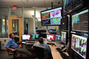
We have completed the orientation briefings for the day and each of the participants is working through the DRT Case (19 May 2010).  This is the first taste that the forecasters are getting with the data.  We have encouraged the forecasters to explore ways to blend the data that they have available to them.

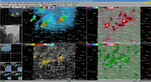
Jessica has captured a screenshot of using a 4-panel display which several forecasters have migrated to:

4 Panel Image showing Z (TL), 3DVAR Composite Updraft (TR), 3DVAR Composite Vorticity (BL), 3DVAR Composite Downdraft (BR)

-K Manross :: Week 2 EWP Weekly Coordinator

Tags: None

Week 2 Under Way!

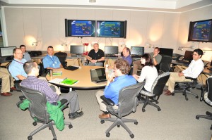
We have begun EWP 2011 Week 2.  With us this week are:

Kevin Brown (OUN), Kevin Donofrio (PQR), Bill Goodman (OKX), Steve Keighton (RNK), Jessica Schultz (ROC)

We will be going through training fore most of the day ending with the 19 May 2010 DRT case.

-K Manross: Week 2 EWP Weekly Coordinator

Tags: None

Week 1 Summary: 9 May – 13 May 2011

As is typically the case with any first week, this week dealt with a combination of tech problems (raid, awips integration, and server failures). However, these difficulties did not keep our forecasters [Jerilyn Billings (ICT), Scott Blair (TOP), Brian Curran (MAF), Andy Taylor (OUN), Brandon Vincent (RAH)] from providing valuable feedback. This feedback will lead to significant changes to our forecaster schedule and the experimental products as early as week 2.

The first significant change will be to incorporate the WES case developed by Darrel Kingfield (WDTB) into the training on Monday afternoons.  Multiple forecasters felt that getting their ‘hands dirty’ early on would allow them to better integrate the experimental products real-time as the week continues…

The second major change will be to the morning shifts.  The focus of the first half of these shifts have been modified such that the forecasters will be first developing an Area Forecast Discussion (to be posted on this blog) that determines the region of interest for possible severe operations later that afternoon.  After lunch these forecasters will be join the Convection Initiation Desk from the EFP; these forecasters will be narrowing down the region of focus for the CI desk as well.

Multiple products received detailed feedback at our weekly debrief.  A few of these are highlighted below:

OUN-WRF:

*Either a web-based or AWIPS-based dProg/dT type product was desired for the OUN-WRF to help the forecasters view the changes with each successive run.

*Access should be provided WFO’s within the forecast domain.

GOES-R Nearcast:

*Useful for short 1-2 hr forecasters, seems to deteriorate after that.

*Showed areas of convective instability, forecasters could compare to values determined through other methods  (e.g., SPC mesoanalysis)

GOES-R UAH-CI/Satcast:

*Yes/No instant solution not useful to forecasters.  Throughout the week the ‘yes’ caused many false alarms.  Temporal statistics or confidence interval may be more useful.

GOES-R pGLM:

*Good situational awareness tool. Provided 30 min + lead time to CG detections during the week.

*Would like to see an IC/CG ratio product.

NSSL 3D-VAR:

*Saw some correlation between updraft products and radar indicators of severe storms, or MRMS products

*FSI or 3D display would be useful for visualization of some of these products.

*Good situational awareness tool & for matching with warning polygons.

*Vorticity products seemed the most useful during the week.

-Kristin Kuhlman (Week 1 Coordinator)

Tags: None

PGLM Assists in Severe Thunderstorm Warning

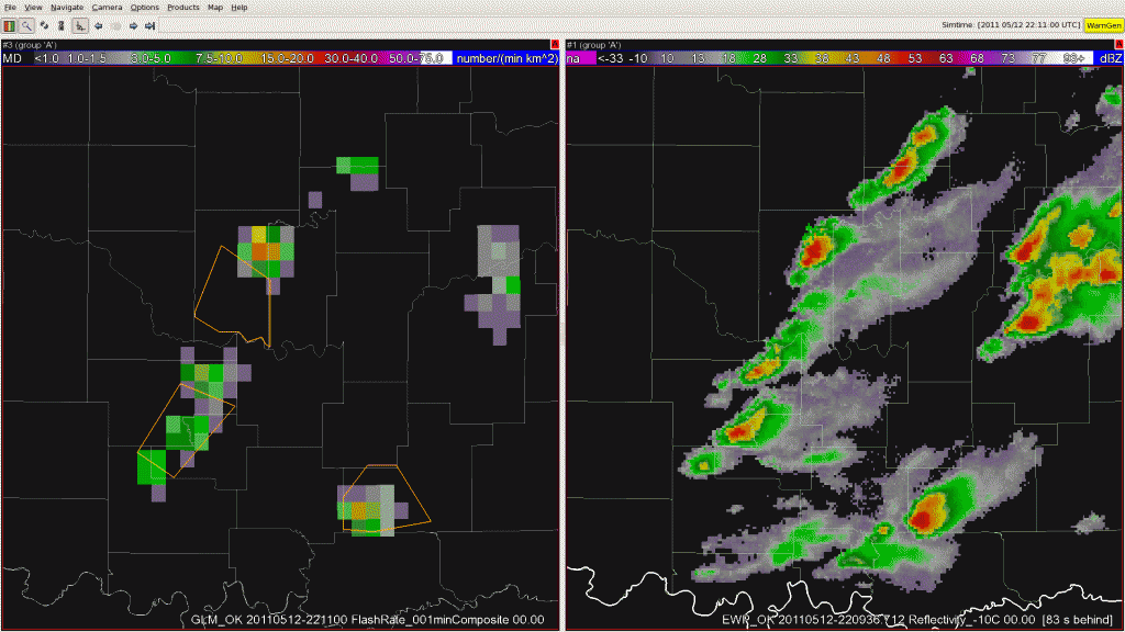
Animation from 12 May 2011 covering from 2211-2226 UTC. The PGLM flash extent density is on the left with the corresponding radar reflectivity on the right. To see the animation, please click on the image.

Today’s afternoon shift started with forecasters working across the Norman, Tulsa, and Little Rock county warning areas.  With the some storms beginning to form south and east of Norman, Oklahoma, it was felt this would be a good opportunity to take another look at the PGLM flash extent density observations and focus on total lightning.  The PGLM flash extent density was very useful in identifying when the first cloud-to-ground strikes would occur.  The PGLM was preceeding the first cloud-to-ground strike by approximately 30 minutes today.

As the the afternoon progressed, the storms began to intensify, both on radar and with the PGLM flash extent density and we shifted from using the PGLM for lightning safety and moved into warning operations.  By 2211 UTC on 12 May 2011 (the first image of the loop shown above), three severe thunderstorm warnings were in effect.  The area of interest for this post is in between the two existing warnings in the west.  At 2211, the PGLM flash extent density was no more than a few flashes per minute.  By 2214 UTC the number of PGLM flashes was already approaching 40 per minute.  This continued to rapidly increase through 2220 UTC when the PGLM flash extent density observe 82 flashes in a 1 minute interval for a single 8×8 km grid box.  This was one of the largest lightning jumps of the day with an increase of 75 flashes per minute in a nine minute time span.  With this major lightning jump, along with the forecaster’s interrogation of radar data, a new severe thunderstorm warning was issued at 2226 UTC.  This warning was later verified with several severe hail reports.

Submitted by Geoffrey Stano, PGLM PI for week of 9-13 May.

12 May 2011 AFD update

CI is occurring within area of MLCAPE aoa 2000 J/kg along cold front extending from just east of KBVO to just north of KADM.  Cells initally were discreet but have been merging/growing into short multicell segments.  Additional isold convection is developing within broad warm sector over northeastern TX northeast into Pushmataha and LeFlore counties. Multicellular convection in this area looks enfeebled both visually and on radar.  Weak low and mid level SR flow indicates an evolution into a linear mode.  Given the amount of instability present along with mid tropospheric jet streak approaching area expect hail to 2 cm and wind gusts to 30 m/s.

Previous forecast had CI in a broad zone extending from near KJLN south to KMEZ.  Mesoanalysis showed a persistent area of lower CAPE in this region, owing to increased cloudiness and inhibited insolation.  Convection in this area appears shallow and unelectrified.

19Z run of the oun-wrf overconvected over southeastern OK and did not represent reality.  The 20z run, however, is sampling the CI and hopefully will provide a better solution.

Blair/Curran

Tags: None

Live Blog: 12 May 2011 – 2030 UTC

We’ve moved straight to storm analysis and warning ops this afternoon.  Forecasters Blair/Curran/Vincent are monitoring Tulsa’s CWA, Taylor in Little Rock CWA and Billings just quickly moved over to OUN to monitor the storms producing lightning in the southern end of the domain.

SPC Watch incorporating EWP operation area
Tags: None

12 May 2011 Morning Forecast Discussion

Initial thoughts focus on the Tulsa (TSA) as well as the Springfield (SGF) and Little Rock (LZK) CWAs for convective initiation and storm maturity. Latest visible satellite imagery depicts congested cumulus field over southeast Oklahoma in response to continued low-level moisture transport and broad ascent with analyzed speed maximum across northeast Texas.

  • Watching two potential scenarios unfold late this morning into the afternoon hours. First, monitoring broad cu field over the next several hours for initial convective development over eastern Oklahoma or western Arkansas as further low-level destabilization transpires and increasing deep layer shear arrives across the area. Model guidance suggests robust activity maturing over northeast OK into northwest Arkansas by early/mid afternoon, and therefore watching the TSA/LZK CWAs.
  • To the west, a more conditional scenario exists along the cold front during the afternoon from Ardmore to Tulsa. Clearing has been noted ahead of this boundary from Graham, TX to Duncan, OK. Stratus deck to the northeast of the corridor appears to be thinning along I-44. Will have to also monitor this area later this afternoon across the TSA CWA for additional robust activity.

Main severe weather threats will likely be large hail up to golfball size and damaging winds in excess of 60 mph with well-organized multicell storms or a few supercells. Tornado threat appears low today with marginal low-level shear within the 0-1 km layer. However, any unresolved storm-scale boundaries from early morning convection within the warm sector of far eastern Oklahoma or western Arkansas may locally enhance isolated tornado threat.

Blair/Curren

Tags: None

Daily Summary: 11 May 2011

Today was an active day for our visiting forecasters, but not in the way we were originally expecting at the end of the previous shift with models initially forecasting development of supercells along the dryline in central and western Oklahoma.  As the CI forecasters began their morning forecast, it was already evident that the ongoing convection in western Oklahoma had greatly modified the forecast from the day before.  Initially, none of the high-resolution models had a handle on the overnight convection, but the OUN-WRF and HRRR were beginning to modify with each successive run, keying in on the development of MCS moving across Oklahoma and the possibility of rotating storms further north near the CO/KS border associated with the closed Low.

The split of forecasters between these two regions seemed to work out well.  Forecasters focusing on the Oklahoma region were able to examine both the pGLM over the Oklahoma LMA network and 3D-VAR data as the MCS reached its peak strength.  Meanwhile, GLD and DDC forecasters monitored CI and later were able to incorporate 3D-VAR data in their analysis as things wound down in central Oklahoma and we moved to the floater domain.  While none of these storms produced tornadoes, the vorticity product from the 3D-VAR was easily incorporated into the analyses and seemed to prove useful in the warning decision process.

11 May 2011 Storm reports

-K. Kuhlman (weekly coordinator)

Tags: None