Outlook – 25 May 2010

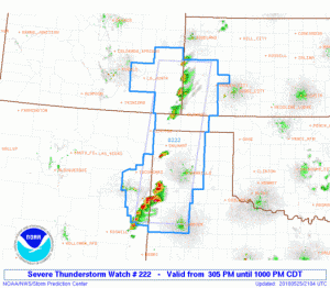
Focus today remains in the southern plains along the dryline/stationary front in the TX/OK panhandles and north to I70 along the CO/KS border. Following the debrief for yesterday’s operational periods and an intial wx briefing, forecasters were divided into the Amarillo and Dodge City CWAs.

Forecasters are working with real-time data for the entire day.  However, technical difficulties with AWIPS and slow data process times has delayed operations though load times have decreased with some code modifications by G. Stumpf.

Kristin Kuhlman (EWP Weekly Coordinator, 24-28 May 2010)

Tags: None

Outlook – 24 May 2010

Today we start week 7 of the 2010 EWP.  Our visitors are Rod Donavon (Des Moines, IA), John Murray (New York, NY), James Sieveking (St. Louis, MO), and David Zaff (Buffalo, NY).

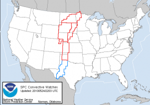
It’s Monday, that means orientation and training for the new forecasters. However, it is also a very active weather day across the central US. A strong negatively tilted trough is ejecting out from the rockies across the northern plains and storms have formed along the warm front extending NE across the Dakotas into Minnesota and along dryline extending south from Goodland, KS through the TX panhandle.  By the time operations began in the HWT, Tornado and Severe Weather Watches had been issued for the central US extending from the Canadian to the Mexican border.
After GOES-R training by project scientists Wayne Feltz (U.Wisconsin-CIMSS) and Eric Bruning (U.Maryland-CICS), a quick IOP was set up for the forecasters for both the Goodland and Dodge City, KS regions.  The main goal of this 2 hr period is to become familiar with and analyze the new GOES-R products such as Convective Initiation, Cloud-Top Cooling, and Overshooting Top in an integrated real-time environment.

Kristin Kuhlman (EWP Weekly Coordinator, 24-28 May 2010)

Tags: None

Outlook – 20 May 2010

We will focus on the ongoing area of convection (tornado watch) in the FWD CWA for the afternoon.  Later in the day, convection is expected to move into the Huntsville LMA domain.  The current plan is to concentrate on the FWD area until around 5 or 5:30pm, take a dinner break, and then switch to the N. Alabama domain for evening operations.

There are two tornado-warned storms along an east-west boundary in the CWA at the start of operations (3pm).

Travis Smith (EWP Weekly Coordinator, 17-21 May 2010)

Tags: None

Outlook – 19 May 2010

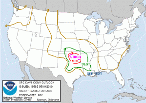
A significant severe weather day is underway for central Oklahoma (SPC high risk [see image] and PDS tornado watch valid from 2pm -10pm CDT).  After a post-event wrap of yesterday’s operations, forecasters quickly reviewed current conditions and model forecasts from the HRRR, NSSL-WRF and OUN-WRF.  By 2pm CDT activities had begun in the HWT with two teams examining the GOES-R convection initiation products for storms along the dryline in western OK.

Travis Smith (EWP Weekly Coordinator, 17-21 May 2010)

Tags: None

Outlook – 18 May 2010

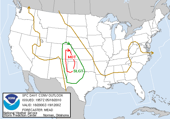
SPC has issued a Moderate Risk for SE Colorado and the TX/OK panhandles.   HRRR is indicating early initiation in SE CO and a later show in SW KS and the panhandles.

Other notes from the discussion:

  • 2345 and 0015 are GOES-R gaps (0015 is calibration, 2345 is full-disk, which happens every three hours).   Otherwise the data come in every 15 minutes.  0Z is a bad time to start looking at CI products
  • Due to lots of cirrus over the area, the CI products may not see too much use today.  However, expect GOES to operate in rapid-scan mode due to the Moderate Risk.

Travis Smith (EWP Weekly Coordinator, 17-21 May 2010)

Tags: None

Outlook – 17 May 2010

Today we start week 6 of the 2010 EWP.  Our visitors are David Blanchard (Flagstaff, AZ), Matt Kramar (Sterling, VA), Ken Pomeroy (Western Region HQ, Salt Lake City, UT), and Darren Van Cleave (Rapid City, SD).

First day of operations for MR/MS and GOES-R today.  We will be focusing on the area primarily large hail threat in SE New Mexico (the same area that Vortex2 is operating today).  MUCAPE is estimated at 4000 J/kg in that area, with upslope flow and 25 kts at 500 mb and a boundary providing a small chance of tornadoes as well (2% on SPC outlook).

Briefings and training will take up the afternoon, and a short IOP will start at 6:30 today.

Day 1 probabilistic hail outlook

Travis Smith (EWP Weekly Coordinator, 17-21 May 2010)

Tags: None

Outlook – 11 June 2009

There are several plays today, from the DCLMA to the Denver area, however we are catchinbg up with archive cases today.  We’re starting off with all the forecastsers going through the 10 Feb 2009 LMA case.  We will then switch over to PAR and CASA archive cases.

Kevin Manross (EWP Weekly Coordinator, 8-12 June 2009)

Tags: None

Outlook – 10 June 2009

We did a very quick debrief of last night’s events.  We then quickly got started with the ongoing convection entering SW OK.

We are trying a first: we have three teams of two running LMA (Steve/Dan M.), CASA (Gail/Bill), and PAR (Daniel N./Chris S.).

Ops started approximately 1930z.

Kevin Manross (EWP Weekly Coordinator, 8-12 June 2009)

Tags: None

Outlook – 9 June 2009

Welcome to the MDT risk.  Today we are looking at two plays/IOPs today.  We’ll start off the day with LMA training and slide right into an LMA IOP over the DC domain.  We’ll break and re-evaluate with the initial idea of operating a MRMS IOP over the MDT risk along S KS.  However, we will switch to a CASA/PAR realtime IOP *if* significant storms develop in/near the CASA domain.

Looks like things are heating up…

Kevin Manross (EWP Weekly Coordinator, 8-12 June 2009)

Tags: None

Outlook – 8 June 2009

There is a shortwave trough entering the Great Lakes region from the west.  Additionally, there is a broad jet streaming from the SW US to the upper MS valley.  At the surface, there is a cold front extending from the SW Great Lakes area SW through OK and into the southern TX PH.

There appear to be three potential plays today.  1) NE CO (DCV), 2) SW OK into the Abilene, TX area, and 3) the Southern Great Lakes area.  Area #2 has greatest potential for (large) hail, and area #3 appears to have greatest tornado potential.

Forecasters are going through their training on WDSSII as well as PAR and MRMS.  We will break at 4 pm and evaluate whethar to begin and IOP (and for which area), or to try and sneak in CASA training.  (LMA training will wait until tomorrow.)

Kevin Manross (EWP Weekly Coordinator, 8-12 June 2009)

Tags: None