An official website of the United States government
Here’s how you know
Official websites use .gov A
.gov website belongs to an official government
organization in the United States.
Secure .gov websites use HTTPS A
lock (
) or https:// means you’ve safely connected to
the .gov website. Share sensitive information only on official,
secure websites.
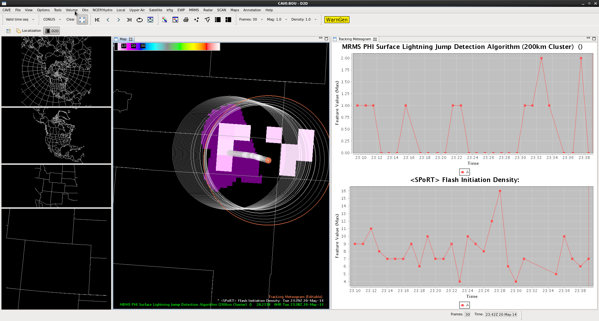
A secondary lightning jump occurs at 23:28 UTC with the same storm east of Denver Co. The lightning jump here reached the 2 sigma level when the total flash rate increased from 8 flashes per minute to 16 flashes per minute in the span of two minutes. This reinforcing lightning jump indicates that the storm’s updraft was still undergoing periods of intensification. Baseball size hail was being reported at the time of the jump, and ping pong ball size hail was reported at 23:35 UTC in association with this storm. Hail was reported as deep as 3 inches on the ground.
*There appears to be a delay between the jump occurrence in the Flash Initiation Density (23:28 UTC) and the LJA sigma plot (23:33 UTC).
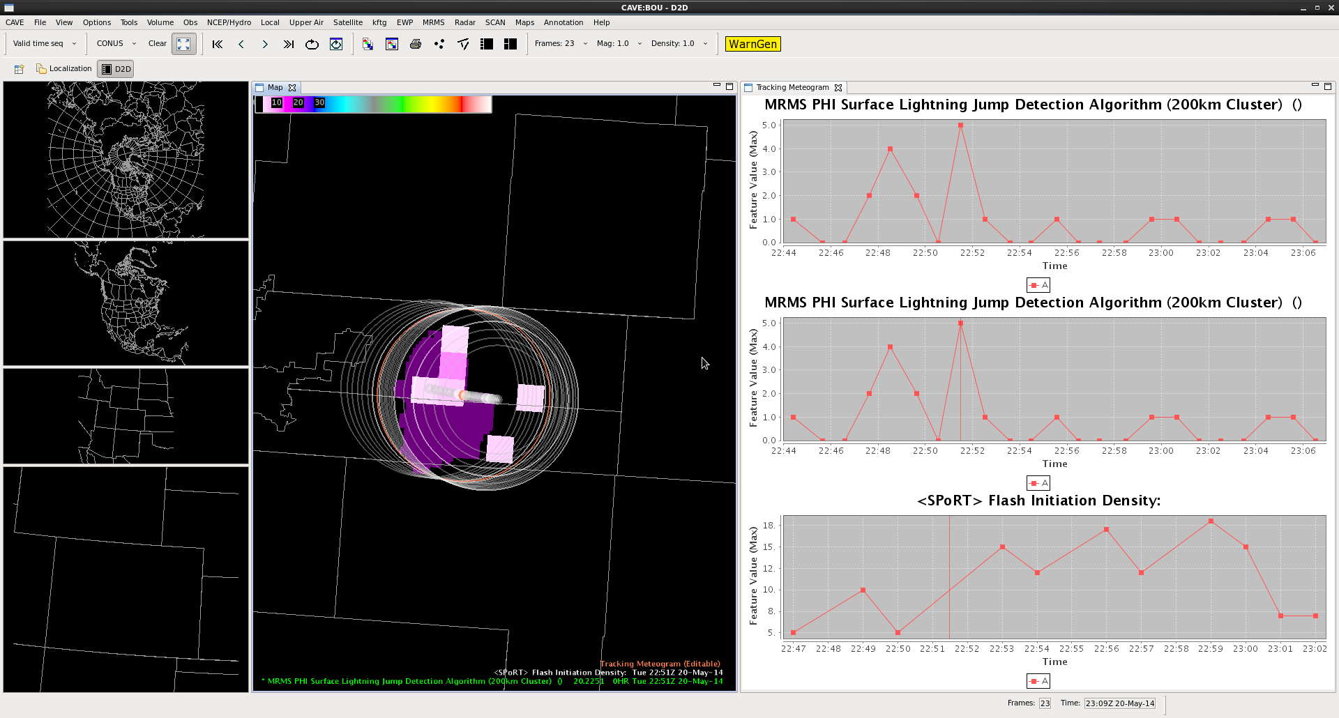
Example lightning jumps from just east of Denver CO at 2251 UTC. The image above shows the lightning jump feature (shaded purple), flash initiation density (FID; pink boxes) and the meteogram output information. The top two panels are the sigma levels at which lightning jump occurs, and the bottom panel is the total flash rate from the PGLM. The Tracking meteogram outline is the white circles encompassing the storm. Two lightning jumps occur at 2249 and 2251 UTC. The first jump occurs as the total flash rate from the PGLM reaches 10 flashes per minute (4 sigma level; anything above 2 sigma indicates a lightning jump according to Schultz et al. 2011), and the second jump occurs with the larger increase in total lightning from 5 flashes a minute to 15 flashes per minute (6 sigma). The jumps are indicating increases in updraft strength and volume,and can be used as a metric in storm intensification. Quarter size hail was reported approximately 20 minutes later at 2310 UTC.
*note the flash rates are likely higher with this storm because the LMA used in this case only had 5-8 sensors active at any given time.*
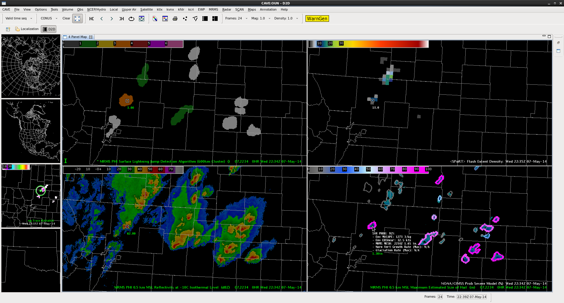
A wider look at the lightning jump grid at 2234 UTC of the NE Boulder CWA… All tracked storms (with greater than 10 flashes per min and within the 150 km LMA domain) are shown. Three tracked cells show some type of sigma jump at this same time. Two in green – 1-sigma (or standard deviation) and one smaller cluster, orange, with a 3-sigma jump.
The three-sigma jump storm corresponds with a ProbSevere 92% and MESH of 1.65 in.
-K. Calhoun, Week 1 Coordinator & Lightning Jump PI
For the first time, we have storms in an LMA domain strong enough to produce images on lightning jump grid.
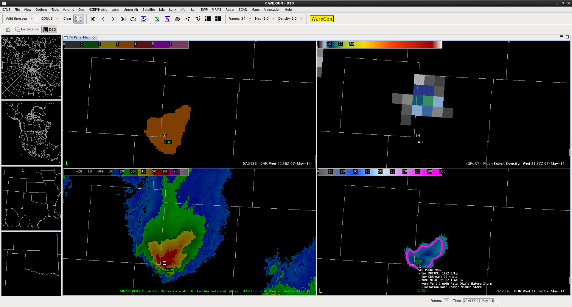
The four-panel image below contains a 3-sigma lightning jump (top left: orange fill region) the pGLM lightning grid (top right: max flash extent density as high as 18 flashes per min), MRMS reflectivity at -10 C (bottom left), and ProbSevere (94%) overlaid on MRMS MESH (bottom right).
AWIPS2 Screenshot from 2136 UTC on 7 May 2014.
This particular combination has provided a couple ideas for lightning jump algorithm development. (1) inclusion of metadata similar to the mouse-over ability of the ProbWarn product. The mouse over for the lightning jump should contain the current flash rate as well as the degree of jump in sigma. (2) Combination with a product similar to ProbWarn (if not, the ProbWarn product itself. This could provide the forecaster information from satellite, lightning and radar all-in-one product. The advantage this provides is that approaches a forecaster-over-the-loop type product without becoming a “black box” as all the information that is part of the product is also provided as metadata. I look forward to working with CIMSS-WI and other researchers on this type of development.
–K. Calhoun, Week 1 Coordinator and Lightning Jump PI
1 Apr 2013 marked the first date of the official data collection period for the 2013 experiment.
A few changes this year: 1) data is now available for analysis the next day via the NSSL FTP server (please contact me for access/location), 2) we have added tracking on the flash extent density (many fewer tracked clusters for these cases since we cannot track a storm prior to entering a LMA region), 3) jumps are now calculated not only for the flash rate of a given storm, but also on the max flash extent density (a 1km square within the storm cluster), and also for the flash rate / storm cluster area, and 4) finally, one a major change is the addition of the Earth Networks Total Lightning Network (ENTLN).
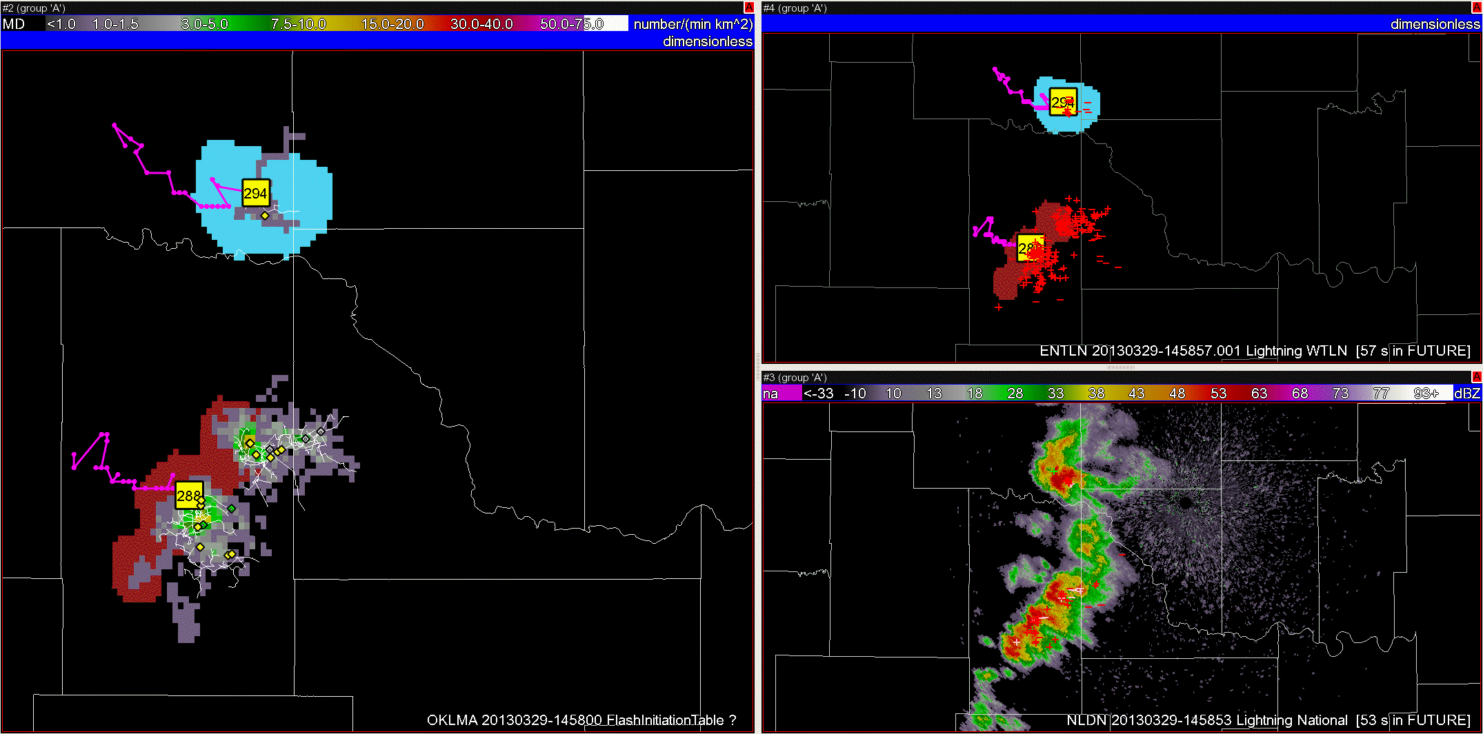
Below is an animated gif from a series of images from the 29 Mar 2013 event over central Oklahoma to illustrate the different products / networks and a few of the issues we’ve seen already (and just prior to start of the “official” data collection).
29 Mar 2013: LMA: initiation locations (diamonds), flash contours (white lines), and flash extent density. KMEANS storm clusters, ID, and past track (Left panel); Earth Networks Total Lightning, KMEANS storm clusters, ID, and past track (top right); NLDN: CG polarity / location and KTLX 0.5 deg Reflectivity (bottom right).
The first thing that should be readily apparent is the differences between detections by the different networks. The LMA provides a location of the flash initiation, the extent of lightning leaders (viewed by Flash Extent Density). The ENTLN provides a lat/lon location of some individual flashes (both in-cloud and cloud-to-ground), though detection efficiency has not been formally established. The NLDN detects primarily cloud-to-ground flashes, providing (lat/lon) locations and polarity.
Here are the jumps (from the various products) from the 29 Mar 2013 event and associated time / cell:
— 1430-1600 UTC jumps (using Ref@-10C to ID and track) —
LMA flash rate: 1438 UTC – cell #288, 1449 UTC – cell #288 LMA max flash density: 1449 UTC – cell #288 LMA flash rate per cluster area (km2): 1438 UTC – cell #288, 1444 UTC – cell #294, 1449 UTC – cell #288 ENTLN flash rate: 1445 UTC – cell #288, 1500 UTC – cell #288
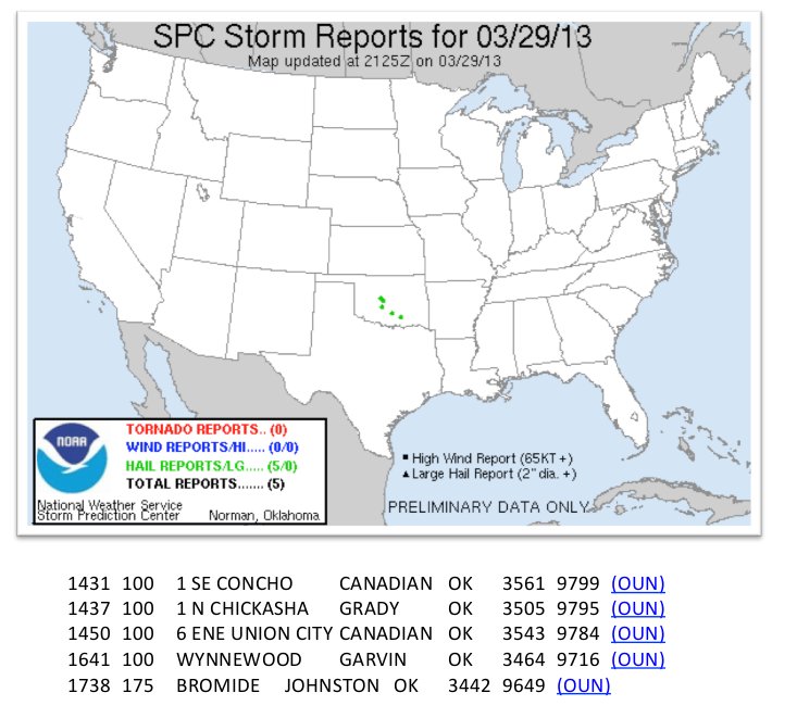
and associated SPC Storm Reports:
First issue in this data set: the central OKLMA was constantly between 5-8 operational stations, contributing to data drop-outs throughout the interesting storm period (note, 6 LMA stations are required to detect any single VHF source point for it to make it past the initial quality control). Obviously, this issue is a concern beyond the OKLMA and today’s data. I am still determining a simple way to flag this issue as part of the xml table output to help the analysis… (more on this below)
Second issue: the server quickly became overloaded and missed creating output files for 3-8 min periods at a time (1540-1830 UTC). We are in the process of determining if we need to load-share with another server or can simply modify some of the data processing. Special note: we have not seen this issue since this event but are constantly watching the load on this server…
———-
The OKLMA definitely has continued to have problems regarding the number of active stations. I’ve included text at the end of this post covering the time period a severe storm (1 in – 2 in hail) crossed over Norman for the case shown below. Included is (ls -al listing of a 10 min period) the file sizes of 10 min of realtime OKLMA raw data files; notice that file size jumps quite wildly from minute to minute. Below that I’ve included the header files from three of those times: 0901, 0903, and 0909 UTC. Each of these minutes have different active stations though only 1 net additional for each time period (11, 12, and 13 active stations, respectfully). But the number of sources detected increases ~exponentially (5, 1919, 5014, respectfully). [Please keep in mind that this is raw VHF source detections and not flashes, the flash sorting occurs later in the processing.]
I believe the addition of the El Reno station at 0903 UTC was key to that increase event detections. I don’t think I’ve seen this drastic of a difference in previous real-time data before. Another reason to, at the very least, add a flag or some type of signifier to the processed data regarding the number of active stations.
(ls -al)
-rw-rw-r– 1 ldm ldm 4456 Mar 31 04:01 LYLOUT_130331_090000_0060.dat
-rw-rw-r– 1 ldm ldm 4384 Mar 31 04:02 LYLOUT_130331_090100_0060.dat
-rw-rw-r– 1 ldm ldm 7274 Mar 31 04:03 LYLOUT_130331_090200_0060.dat
-rw-rw-r– 1 ldm ldm 146025 Mar 31 04:04 LYLOUT_130331_090300_0060.dat
-rw-rw-r– 1 ldm ldm 7574 Mar 31 04:05 LYLOUT_130331_090400_0060.dat
-rw-rw-r– 1 ldm ldm 4382 Mar 31 04:06 LYLOUT_130331_090500_0060.dat
-rw-rw-r– 1 ldm ldm 120348 Mar 31 04:07 LYLOUT_130331_090600_0060.dat
-rw-rw-r– 1 ldm ldm 105323 Mar 31 04:08 LYLOUT_130331_090700_0060.dat
-rw-rw-r– 1 ldm ldm 4977 Mar 31 04:09 LYLOUT_130331_090800_0060.dat
-rw-rw-r– 1 ldm ldm 375058 Mar 31 04:11 LYLOUT_130331_090900_0060.dat
[wdssii@cloudy LMA]$ more LYLOUT_130331_090100_0060.dat
 New Mexico Tech Lightning Mapping Array - analyzed data
 Analysis program: /data1/rtlma/bin/lma_analysis_v10.11.1RT/lma_analysis -d 20130331 -t 090100 -s 60 -l /data1/rtlma/bin/lma_analysis_v10.11.1RT/ok.loc -o /data
 1/rtlma/dec_data/130331/09/01
 Analysis program version: 10.11.1RT
 Analysis started: Sun Mar 31 04:02:20 2013
 Analysis finished: Sun Mar 31 04:02:26 2013
 Data start time: 03/31/13 09:01:00
 Number of seconds analyzed: 60
 Location: OK LMA 2002/2005
 Coordinate center (lat,lon,alt): 35.2791257 -97.9178678 417.90
 Maximum diameter of LMA (km): 194.538
 Maximum light-time across LMA (ns): 649039
 Number of stations: 19
 Number of active stations: 11
 Active stations: C D G H I N Y A U B Z
 Minimum number of stations per solution: 6
 Maximum reduced chi-squared: 5.00
 Maximum number of chi-squared iterations: 20
 Station information: id, name, lat(d), lon(d), alt(m), delay(ns), board_rev, rec_ch
 Sta_info: C Chickasha SE 35.0043455 -97.9073041 339.09 146 3 3
 Sta_info: D Dutton 35.2451748 -98.0754888 420.11 253 3 3
 Sta_info: E El Reno 35.4785046 -98.0089380 419.99 158 3 3
 Sta_info: F FAA 35.3843732 -97.6208285 390.30 52 3 3
 Sta_info: G Goldsby 35.1325178 -97.5185999 382.30 151 3 3
 Sta_info: H Chickasha N 35.1299688 -97.9592651 341.93 159 3 3
 Sta_info: I Minco SE 35.2791257 -97.9178678 417.90 156 3 3
 Sta_info: M Middleberg 35.1347342 -97.7257633 414.68 159 3 3
 Sta_info: N Newcastle 35.2564446 -97.6589268 396.65 155 3 3
 Sta_info: O OKC 35.4015724 -97.6014842 393.99 119 3 3
 Sta_info: W Minco W 35.3622021 -98.0397279 415.65 158 3 3
 Sta_info: Y Yukon 35.4402883 -97.7782383 405.96 162 3 3
 Sta_info: A Altus Airport 34.6966400 -99.3406100 435.60 148 3 3
 Sta_info: P Prairie Hill 34.5950200 -99.4936800 447.40 159 3 3
 Sta_info: U Mangum 34.8592300 -99.3612100 483.10 174 3 3
 Sta_info: B Bluff 34.7679400 -99.5392400 509.60 234 3 3
 Sta_info: O Olustee 34.5195200 -99.4349400 407.50 157 3 3
 Sta_info: R Granite 34.9733400 -99.4487200 492.90 168 3 3
 Sta_info: Z Zombie 34.7116100 -99.0802600 427.90 159 3 3
 Station data: id, name, win(us), dec_win(us), data_ver, rms_error(ns), sources, %, <P/P_m>, active
 Sta_data: C Chickasha SE 80 10 70 2 40.0 1.77 A
 Sta_data: D Dutton 80 10 70 3 60.0 9.30 A
 Sta_data: E El Reno 0 0 70 0 0.0 0.00 NA
 Sta_data: F FAA 0 0 70 0 0.0 0.00 NA
 Sta_data: G Goldsby 80 10 70 5 100.0 0.88 A
 Sta_data: H Chickasha N 80 10 70 4 80.0 3.71 A
 Sta_data: I Minco SE 80 10 70 0 0.0 0.00 A
 Sta_data: M Middleberg 0 0 70 0 0.0 0.00 NA
 Sta_data: N Newcastle 80 10 70 4 80.0 0.99 A
 Sta_data: O OKC 0 0 70 0 0.0 0.00 NA
 Sta_data: W Minco W 0 0 70 0 0.0 0.00 NA
 Sta_data: Y Yukon 80 10 70 3 60.0 2.48 A
 Sta_data: A Altus Airport 80 10 70 1 20.0 0.06 A
 Sta_data: P Prairie Hill 0 0 70 0 0.0 0.00 NA
 Sta_data: U Mangum 80 10 70 2 40.0 0.35 A
 Sta_data: B Bluff 80 10 70 3 60.0 1.06 A
 Sta_data: O Olustee 0 0 70 0 0.0 0.00 NA
 Sta_data: R Granite 0 0 70 0 0.0 0.00 NA
 Sta_data: Z Zombie 80 10 70 3 60.0 0.08 A
 Metric file version: 4
 Station mask order: ZROBUPAYWONMIHGFEDC
 Data: time (UT sec of day), lat, lon, alt(m), reduced chi^2, P(dBW), mask
 Data format: 15.9f 12.8f 13.8f 9.2f 6.2f 5.1f 7x
 Number of events: 5
 *** data ***
 32483.420073930 33.10235512 -100.69250915 450975.32 2.11 36.6 0x01932
 32492.744501099 34.85556274 -98.92710217 43824.93 1.60 20.7 0x4c032
 32497.223350796 35.13756612 -97.95587964 1403.88 0.83 18.8 0x04133
 32504.743797217 35.44091271 -97.67734666 45462.14 4.07 23.5 0x48911
 32506.247514080 31.47113948 -99.42825852 425506.86 4.15 36.4 0x48930
———————–
[wdssii@cloudy LMA]$ more LYLOUT_130331_090300_0060.dat
 New Mexico Tech Lightning Mapping Array - analyzed data
 Analysis program: /data1/rtlma/bin/lma_analysis_v10.11.1RT/lma_analysis -d 20130331 -t 090300 -s 60 -l /data1/rtlma/bin/lma_analysis_v10.11.1RT/ok.loc -o /data
 1/rtlma/dec_data/130331/09/03
 Analysis program version: 10.11.1RT
 Analysis started: Sun Mar 31 04:04:20 2013
 Analysis finished: Sun Mar 31 04:04:39 2013
 Data start time: 03/31/13 09:03:00
 Number of seconds analyzed: 60
 Location: OK LMA 2002/2005
 Coordinate center (lat,lon,alt): 35.2791257 -97.9178678 417.90
 Maximum diameter of LMA (km): 194.538
 Maximum light-time across LMA (ns): 649039
 Number of stations: 19
 Number of active stations: 12
 Active stations: C D E G H I N Y P U R Z
 Minimum number of stations per solution: 6
 Maximum reduced chi-squared: 5.00
 Maximum number of chi-squared iterations: 20
 Station information: id, name, lat(d), lon(d), alt(m), delay(ns), board_rev, rec_ch
 Sta_info: C Chickasha SE 35.0043455 -97.9073041 339.09 146 3 3
 Sta_info: D Dutton 35.2451748 -98.0754888 420.11 253 3 3
 Sta_info: E El Reno 35.4785046 -98.0089380 419.99 158 3 3
 Sta_info: F FAA 35.3843732 -97.6208285 390.30 52 3 3
 Sta_info: G Goldsby 35.1325178 -97.5185999 382.30 151 3 3
 Sta_info: H Chickasha N 35.1299688 -97.9592651 341.93 159 3 3
 Sta_info: I Minco SE 35.2791257 -97.9178678 417.90 156 3 3
 Sta_info: M Middleberg 35.1347342 -97.7257633 414.68 159 3 3
 Sta_info: N Newcastle 35.2564446 -97.6589268 396.65 155 3 3
 Sta_info: O OKC 35.4015724 -97.6014842 393.99 119 3 3
 Sta_info: W Minco W 35.3622021 -98.0397279 415.65 158 3 3
 Sta_info: Y Yukon 35.4402883 -97.7782383 405.96 162 3 3
 Sta_info: A Altus Airport 34.6966400 -99.3406100 435.60 148 3 3
 Sta_info: P Prairie Hill 34.5950200 -99.4936800 447.40 159 3 3
 Sta_info: U Mangum 34.8592300 -99.3612100 483.10 174 3 3
 Sta_info: B Bluff 34.7679400 -99.5392400 509.60 234 3 3
 Sta_info: O Olustee 34.5195200 -99.4349400 407.50 157 3 3
 Sta_info: R Granite 34.9733400 -99.4487200 492.90 168 3 3
 Sta_info: Z Zombie 34.7116100 -99.0802600 427.90 159 3 3
 Station data: id, name, win(us), dec_win(us), data_ver, rms_error(ns), sources, %, <P/P_m>, active
 Sta_data: C Chickasha SE 80 10 70 1841 95.9 3.53 A
 Sta_data: D Dutton 80 10 70 67 3.5 1.62 A
 Sta_data: E El Reno 80 10 70 1876 97.8 1.11 A
 Sta_data: F FAA 0 0 70 0 0.0 0.00 NA
 Sta_data: G Goldsby 80 10 70 1888 98.4 1.41 A
 Sta_data: H Chickasha N 80 10 70 78 4.1 0.65 A
 Sta_data: I Minco SE 80 10 70 17 0.9 0.00 A
 Sta_data: M Middleberg 0 0 70 0 0.0 0.00 NA
 Sta_data: N Newcastle 80 10 70 1868 97.3 1.18 A
 Sta_data: O OKC 0 0 70 0 0.0 0.00 NA
 Sta_data: W Minco W 0 0 70 0 0.0 0.00 NA
 Sta_data: Y Yukon 80 10 70 30 1.6 5.42 A
 Sta_data: A Altus Airport 0 0 70 0 0.0 0.00 NA
 Sta_data: P Prairie Hill 80 10 70 1909 99.5 0.00 A
 Sta_data: U Mangum 80 10 70 17 0.9 0.18 A
 Sta_data: B Bluff 0 0 70 0 0.0 0.00 NA
 Sta_data: O Olustee 0 0 70 0 0.0 0.00 NA
 Sta_data: R Granite 80 10 70 20 1.0 0.49 A
 Sta_data: Z Zombie 80 10 70 1908 99.4 0.42 A
 Metric file version: 4
 Station mask order: ZROBUPAYWONMIHGFEDC
 Data: time (UT sec of day), lat, lon, alt(m), reduced chi^2, P(dBW), mask
 Data format: 15.9f 12.8f 13.8f 9.2f 6.2f 5.1f 7x
 Number of events: 1919
 *** data ***
 32580.015923202 35.30497068 -98.02190064 7436.24 1.23 16.2 0x42115
 32580.028474879 35.03748360 -97.48952779 7700.38 0.15 16.4 0x42115
————————————–
[wdssii@cloudy LMA]$ more LYLOUT_130331_090900_0060.dat
 New Mexico Tech Lightning Mapping Array - analyzed data
 Analysis program: /data1/rtlma/bin/lma_analysis_v10.11.1RT/lma_analysis -d 20130331 -t 090900 -s 60 -l /data1/rtlma/bin/lma_analysis_v10.11.1RT/ok.loc -o /data1/rtlma
 /dec_data/130331/09/09
 Analysis program version: 10.11.1RT
 Analysis started: Sun Mar 31 04:10:20 2013
 Analysis finished: Sun Mar 31 04:10:56 2013
 Data start time: 03/31/13 09:09:00
 Number of seconds analyzed: 60
 Location: OK LMA 2002/2005
 Coordinate center (lat,lon,alt): 35.2791257 -97.9178678 417.90
 Maximum diameter of LMA (km): 194.538
 Maximum light-time across LMA (ns): 649039
 Number of stations: 19
 Number of active stations: 13
 Active stations: C D E G H I N W Y P U R Z
 Minimum number of stations per solution: 6
 Maximum reduced chi-squared: 5.00
 Maximum number of chi-squared iterations: 20
 Station information: id, name, lat(d), lon(d), alt(m), delay(ns), board_rev, rec_ch
 Sta_info: C Chickasha SE 35.0043455 -97.9073041 339.09 146 3 3
 Sta_info: D Dutton 35.2451748 -98.0754888 420.11 253 3 3
 Sta_info: E El Reno 35.4785046 -98.0089380 419.99 158 3 3
 Sta_info: F FAA 35.3843732 -97.6208285 390.30 52 3 3
 Sta_info: G Goldsby 35.1325178 -97.5185999 382.30 151 3 3
 Sta_info: H Chickasha N 35.1299688 -97.9592651 341.93 159 3 3
 Sta_info: I Minco SE 35.2791257 -97.9178678 417.90 156 3 3
 Sta_info: M Middleberg 35.1347342 -97.7257633 414.68 159 3 3
 Sta_info: N Newcastle 35.2564446 -97.6589268 396.65 155 3 3
 Sta_info: O OKC 35.4015724 -97.6014842 393.99 119 3 3
 Sta_info: W Minco W 35.3622021 -98.0397279 415.65 158 3 3
 Sta_info: Y Yukon 35.4402883 -97.7782383 405.96 162 3 3
 Sta_info: A Altus Airport 34.6966400 -99.3406100 435.60 148 3 3
 Sta_info: P Prairie Hill 34.5950200 -99.4936800 447.40 159 3 3
 Sta_info: U Mangum 34.8592300 -99.3612100 483.10 174 3 3
 Sta_info: B Bluff 34.7679400 -99.5392400 509.60 234 3 3
 Sta_info: O Olustee 34.5195200 -99.4349400 407.50 157 3 3
 Sta_info: R Granite 34.9733400 -99.4487200 492.90 168 3 3
 Sta_info: Z Zombie 34.7116100 -99.0802600 427.90 159 3 3
 Station data: id, name, win(us), dec_win(us), data_ver, rms_error(ns), sources, %, <P/P_m>, active
 Sta_data: C Chickasha SE 80 10 70 4319 86.1 2.37 A
 Sta_data: D Dutton 80 10 70 84 1.7 7.58 A
 Sta_data: E El Reno 80 10 70 4455 88.9 0.91 A
 Sta_data: F FAA 0 0 70 0 0.0 0.00 NA
 Sta_data: G Goldsby 80 10 70 4070 81.2 1.26 A
 Sta_data: H Chickasha N 80 10 70 149 3.0 1.27 A
 Sta_data: I Minco SE 80 10 70 38 0.8 0.00 A
 Sta_data: M Middleberg 0 0 70 0 0.0 0.00 NA
 Sta_data: N Newcastle 80 10 70 4562 91.0 1.05 A
 Sta_data: O OKC 0 0 70 0 0.0 0.00 NA
 Sta_data: W Minco W 80 10 70 4128 82.3 5.69 A
 Sta_data: Y Yukon 80 10 70 95 1.9 3.14 A
 Sta_data: A Altus Airport 0 0 70 0 0.0 0.00 NA
 Sta_data: P Prairie Hill 80 10 70 4804 95.8 0.00 A
 Sta_data: U Mangum 80 10 70 47 0.9 0.08 A
 Sta_data: B Bluff 0 0 70 0 0.0 0.00 NA
 Sta_data: O Olustee 0 0 70 0 0.0 0.00 NA
 Sta_data: R Granite 80 10 70 60 1.2 0.22 A
 Sta_data: Z Zombie 80 10 70 4368 87.1 0.32 A
 Metric file version: 4
 Station mask order: ZROBUPAYWONMIHGFEDC
 Data: time (UT sec of day), lat, lon, alt(m), reduced chi^2, P(dBW), mask
 Data format: 15.9f 12.8f 13.8f 9.2f 6.2f 5.1f 7x
 Number of events: 5014
 *** data ***
 32940.000377496 35.03210068 -97.80952546 4892.64 0.47 17.7 0x42515
 32940.014071929 35.06811963 -97.21688673 4949.58 1.00 16.3 0x02515
Finally, a bit more activity in some of our domains this week. In the last couple hours widespread severe (and near severe) storms have developed across the WTLMA. Activity is expected to continue in the SW OKLMA network and possibly central OK later tonight. SHAVE is currently actively calling in the region west and NW of Lubbock, reporting primarily pea-to-dime-size hail (severe winds are likely to be a larger factor with these storms) .
Above image is screen capture of realtime webpage active using google maps at 2231 UTC on 26 Sept 2012. Storms with jumps are noted, image shows timing & flash rate at that time (total per min & CG per 5 min) for storms tracked using Scale 1 (data for storm tracking at smaller and larger scales also available). SHAVE data collection points are denoted by green (0.25-0.75 in hail) and grey (no hail) circles.
Data collection update:
17 Sept 2012: NALMA 2000-2200 UTC (severe possibly out-of-range)
18 Sept 2012: DCLMA 1430-2230 UTC
25 Sept 2012: OKLMA 2300-0400 UTC (SHAVE data available)
26 Sept 2012: WTLMA/ OKLMA 1900 – ? (SHAVE data available)
Relatively quiet weather has continued over the domains during the last week. Today’s event over the NALMA is likely to be primarily a heavy rain event, but it’s still a good opportunity to show how the same storm system is tracked simultaneously at different scales. For the LJA, we are running 3 scales concurrently: scale 0 (200 km^2 min cluster size), scale 1 (600 km^2), and scale 2 (1000 km^2):
Scale 0 over the NALMA domain. Clusters are the regions identified by the colorful shapes over the reflectivity at -10 C plot.similar to the previous image, except for Scale 1. similar to the previous images, except for Scale 2. At scale 2, the identified storm clusters are allowed to grow unbounded.
(severe, or near severe) events since last update:
This week has been a bit more active than we’ve seen in recent weeks… In fact, currently the storm in SW Oklahoma county just produced two lightning jumps (2021/2024 & 2030 UTC) about the same time that radar velocity indicated the start of a downburst…
Lightning jump associated with storm over SW Oklahoma county at 2024 UTC. Top row of table includes values for this cell (#403352). Right panel shows tracked region selected at smallest scale (scale 0). Note: scale 1 & 2 were not tracking storms over the region due to size requirements. i.e., these storms were too small.TDWR velocity at 2027 UTC over southwest Oklahoma county.
Activity has also occurred in other regions as well this week. Below is a breakdown of (severe/near severe activity):
2 Sept 2012: NALMA 1900-0300 UTC
5 Sept 2012: WTLMA/OKLMA (sw) 2330-0300 UTC
6 Sept 2012: DCLMA 1030-1330 UTC
7 Sept 2012: OKLMA 2000-? UTC
We’re still actively collecting data. Activity has been rather minimal across the networks for the last couple weeks (SHAVE has been down since the start of the new semester).
Hurricane Isaac made landfall last week, primarily affecting regions outside the LMA domains. Convective rain bands moved over the FL-LDAR network on 27 Aug, though they produced very little lightning (the MLB office had 2 preliminary storm reports for the day though likely in regions out-of-range of the FL-LDAR system).
Severe storms occurred over the northern Alabama network on 2 Sept 2012 as the remnants of Isaac moved eastward out of Arkansas and into the Tennessee Valley. 21 preliminary severe wind reports were recorded in the Huntsville county warning area with these storms.
Summary since last blog post:
24-25 Aug 2012: WTLMA, 0300-0600 UTC (25th)
25 Aug 2012: OKLMA/WTLMA, 2100-0200 UTC
26 Aug 2012: DCLMA, 1700-1900 UTC
27 Aug 2012: FL-LDAR (likely out-of-range), 1400-1600 UTC
SHAVE is currently on break for the first week of classes, activity should restart next week 27 Aug as needed.
Continuous data collection is still ongoing. A brief outage of the WTLMA prohibited data from coming into NSSL realtime, but that has been restarted as of 0600 UTC on 21 Aug 2012.
Storm activity this week has been marginally severe at best, with most of the networks having no activity.
21 Aug 2012: FL-LDAR domain, 1800-2200 UTC
20 Aug 2012: WTLMA (did not receive data from this network in realtime, but event could be reprocessed if necessary. May have been outside of network 3d range)
17 Aug 2012: NALMA (likely out-of-range of severe activity)