Outlook – 8 May 2008

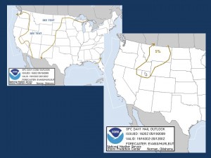
Two areas of concern grabs our attention today. One area is associated with the departing system toward the east coast where a slight risk has been laid out from AL to VA. Storms were already occurring in AL with several TORs at briefing time, however the threat may focus more in the Carolinas and VA by the time any prob warn activities commenced. The second area is a slight risk area in KS and northern OK. This area already has convection forming in eastern CO. The moisture’s a little light but lapse rates are much steeper than the eastern risk zone. Both areas have sufficient shear for supercells.

The shortwave trough in CO is progged to move well to the north of the PAR and CASA areas and the probability of convection is small. The most likely time for convection in these areas would be after 0300 UTC.

We will probably go with probability warning activities following the SHAVE experiment.

At 2200 UTC, SHAVE was already active on two large hail producing supercells in western KS. Probwarn activities are focusing on the DDC area again.

Jim LaDue (EWP Weekly Coordinator, 5-9 May)

Tags: None

Thoughts on all-digital damage survey

Since some of the damage from last night was across the street from my kids’ school, I set off from there this morning with only a Nokia N95 as assistance. For those who don’t know, this cameraphone is pretty nice:

  • 5 megapixel camera (works fine outdoors, though some pics come out a bit blurry it is acceptable)
  • built-in GPS
  • can geo-tag and upload pictures to Flickr.com with “zonetag” software, for instant viewing by a remote user in Google Earth.

I basically drove around and took pictures with the phone and then uploaded them. It seemed great! Only, when I got back to NSSL, I discovered that it didn’t really go so well:

  • GPS locations were not quite accurate due to some sky blockage (big trees). Next time I’ll bring my SIRF3 (highly accurate) bluetooth GPS to connect to the phone, but that kind of defeats the purpose of having built-in GPS!
  • At some point, my phone reset, and it lost the GPS logging. Of course, it didn’t tell me this, and even though it was still uploading pictures they were all geotagged to the location where it reset. Oops!
  • This meant that I had to manually position the rest of the photos (and remember where I took them) using Google Earth / Picasa to make the KML file.

The practical upshot is that the GPS Logger / regular digital camera survey method will still work better, unless you want to auto-upload your results to a web site.

(Travis Smith)

Tags: None

Damage Surveys for May 7 event

A quick look at the PAR data indicates two separate short-lived circulations that passed through Oklahoma County and were scanned by the PAR.

Survey photos KML from Piedmont to Meridian and NW Expressway are attached. There was an almost continuous narrow path between the two locations, though part of it would have been over Lake Overholser.

  • Width = 50 yards usually, 120 yards at it’s widest damage point (baseball fields — I walked it off and also measured in Google Earth)
  • Length = 7.5 miles
  • TS DOD 3 — lots of big trees uprooted in the Ann Arbor and 50th street area –> EF1 (though barely).
  • SRB DOD 2 or 4 — concession stand at PCO fields was built like this (concrete blocks, metal roof) and lost about 25% of the roof. –> EF0 or low-end EF1

Too bad there is no EF-scale DOD for movable metal bleachers. I saw loads of those tossed around. One of them badly bent a steel-braced awning at the baseball fields.

A photo from newsok.com was in the back yard of someone’s house in Yukon, so I didn’t get in to see the damage myself. The only other stuff I saw in that area were some stockade fences blown down and some limbs removed (no uprooted trees or anything). So that part of the path could be EF1 based on the picture, but EF0 based on everything else.

Kiel and Angelyn surveyed the Edmond / NOKC circulation. Kiel writes:

I’ll use tornado lightly here…radar really helped pick this guy out. Anyways, attached is Angelyn’s and my survey. Gonna go EF0 on this bad boy…sporadic damage that eventually lined up into a path (2.8 miles long by 20 yards wide).

DI/DODs:
Trees (hard/softwood): DOD 3
Single family home: DOD 2
Aparment building: DOD 2

Given the last DI/DOD, winds up to 82 MPH.

(Travis Smith)

Tags: None

Summary – 7 May 2008

There was little doubt today that convection would occur in the CASA and PAR domains. An upper low tracked across southern and central OK while the surface low tracked basically underneath. The strongest low-level jet and low-level vertical wind shear was to remain east of the dryline, or along I-35 south of OKC and points east. This is where most forecasters (e.g., SPC, EWP, WFO) thought the best tornado potential would be. However, we failed to appreciate the potential for large amounts of ambient vertical vorticity to produce tornadoes provided sufficient amounts of convection. The low-level low tightened amidst an abundance of cold core convection forming in western OK and eventually, central Oklahoma, where several nonmesocyclonic tornadoes formed including two in northern Oklahoma City, one just 2 miles south of the National Weather Center, and one near Paoli.

While in the CASA domain, the convection also helped intensify the cold front coming in from the west. The result was a damaging wind event. One area of convection surged across Lawton to Chickasha resulting in damaging winds in both places. In fact both the Lawton and Rush Springs radar sampled winds in excess of 60kts in the closest range gates. The Lawton radar stopped reporting for about an hour after it experienced severe winds.

The developing squall line came into central OK in two segments. A north-south segment approached OKC accompanied by a gust front with substantial vertical vorticity. One TVS formed near Lake Overholser producing a tornado there which tracked a couple miles to the northeast (see Travis Smith’s damage survey description). A second circulation developed near Edmond and tracked southeast. This segment of the squall line was centered within the larger scale low and the PAR could easily detect the rotation of individual cells around a common center. The PAR could also more easily detect the evolution of the circulation centers than with the KTLX radar. The other segment came in toward Norman from the southwest and represented the eastward continuation of the severe gust front within the CASA network. Substantial vertical vorticity along this gust front allowed one TVS to form just south of Norman which then produced an EF0 tornado along the Norman/Noble border. The PAR was focused on the OKC storms and thus was unable to cover the Norman TVS. However the TDWR did sample this feature at a one minute frequency and was able to detect a TVS with a 50kt Delta-V. Members of the EWP watched the ragged cone-shaped funnel to the south of the National Weather Center around 2225 UTC.

CASA summary:

Brian and Craig worked the CASA network. They found the following advantages:

  • Gradients in velocity were much larger in the CASA than the 88D as noted in 2006 UTC
  • Peak velocities were slightly larger in the CASA than the 88D. While both radar types showed severe values, the CASA radars showed those values at a much lower elevation. Both the Lawton and Rush Springs radar showed >60kts at their respective nearest range gates.
  • The RHI were extremely useful and was used at least on 2032 UTC, 2121 UTC, and 2131 UTC. The RHI was generated automatically from each radar in each scan along the radial containing the highest reflectivity.
  • The 3DVAR wind speed analysis proved especially useful to the forecasters as it depicted 2-D winds that appeared to have agreed with the radial velocity base data for several wind events, especially the Lawton area and then points northeast from there.
  • The data appeared much cleaner than last year.

Brian, Craig and Don viewing CASA radar data

There were issues with the CASA too:

  • The RHI, while useful, was too automated. The forecasters wished to have some control over this function in order to follow storm evolution. However the number of storms exhibiting a peak reflectivity in a particular radar’s domain from scan to scan kept changing the RHI azimuth.

PAR summary:

Kristen operated the PAR selecting 90 deg sectors while Bill evaluated its usefulness in warnings. There were certain advantages with the the PAR over the 88D

  • At 2020 UTC, the PAR could detect low-level circulation 3-4 min prior to the 88D in the supercell approaching Pauls Valley.
  • At 2131 UTC, the PAR showed an azimuthal velocity couplet (low-level circulation) at a merger of a small echo with a larger echo in northern Garvin county. The KTLX radar did not show it as well.
  • At 2216 UTC, the PAR was able to track the evolution of small vortices along the gust front in western Oklahoma county. The KTLX radar could detect them but not track their evolution given the temporal frequency of its scans.
  • At 2221 UTC, the PAR could easily track the 2-D motion of reflectivity echoes around a common center in northern Oklahoma county.

Dr. Pam Heinselman looks onward as the PAR evaluation team monitor a swirling mass of convection over Oklahoma City.

There were some issues with the PAR, and WDSS-II’s capability of displaying its data

  • Storms moving across radials at close ranges required frequent sector updating
  • Bill had issues attempting to view virtual volume scans with interlaced VCPs in WDSS-II
  • The PAR data is very useful when looped at high speeds. WDSS-II needs the capability to display long loops at high speeds where users can scrub the loop back and forth with VCR and other types of controls (e.g., see Hunter/Gatherer software).

Jim LaDue (EWP Weekly Coordinator, 5-9 May)

Tags: None

Live Blog – 7 May 2008 (5:57pm)

KTLX and TDWR shows a TVS 1.5 mi south of the NWC. It’s too far for the CASA though the Chickasha radar showed other shear features along the same gust front to the west.

We have a visual of a V-shaped loose funnel just south of the NWC – picture to follow. Rapid rising motion and some circulation may mean a weak tornado may have occurred just to the south.

V-shaped funnel south of the NWC

PAR snagged spectacular circulation deforming the reflectivity field over OKC.

Donut-shaped reflectivity field being deformed by the circulation around the surface low in OKC.  A tornado was recently reported in west OKC.

Jim LaDue (EWP Weekly Coordinator, 5-9 May)

Tags: None

Live Blog – 7 May 2008 (5:23pm)

TDWR shows numerous vortices rolling up along the north edge of the intense gust front bowing north in McClain county. Chickasha CASA radar shows them but not quite as well. KTLX shows it too just north of Washington.

PAR is focused on the OKC storm only where the echoes wrapped around the vortex/synoptic low center and almost closed off an eye!

Jim LaDue (EWP Weekly Coordinator, 5-9 May)

Tags: None

Live Blog – 7 May 2008 (5:16pm)

PAR: Kristen’s moving the sector to keep up with a TOR warned squall line component going through OKC. PAR shows echo features around the squall line segment swirling around a broad center while velocity shows vortices rolling up along the gust front interface. It’s amazing to see the evolution of these short-lived features.

This feature is colocated with the surface low center.

Jim LaDue (EWP Weekly Coordinator, 5-9 May)

Tags: None

Live Blog – 7 May 2008 (4:41pm)

CASA: Rush Springs radar shows 73.5kts inbound at .7kft just east of the radar, like, right on top of it. KTLX shows -62 kts in a small area east of Rush SPrings at 2139Z. So Rush Springs had a jump of 5 min on KTLX. No warning.

Jim LaDue (EWP Weekly Coordinator, 5-9 May)

Tags: None

Live Blog – 7 May 2008 (4:36pm)

CASA: Chickasha RHI facing 285 deg shows an upshear tilted line segment with the gustfront appearing to leave cells behind its leading edge.

PAR: There’s a azimuthal cyclonic couplet in northern Garvin county. There appeared to be a merger of a small supercellular shaped echo with a large round echo to its south. The couplet occurred at the merger point on the supercellular echo’s rear. KTLX doesn’t show it as well.

PAR noise is there but not bothersome.

Jim LaDue (EWP Weekly Coordinator, 5-9 May)

Tags: None