Summary – 21 May 2009

The LMA archive took the group up through 6 PM.  We then reconvened with pizza at 6:30pm, and began work on three tasks: PAR archive cases, a CASA surface wind prediction exercise, and a free-form exploration of CASA data from earlier this spring.  We will work these tasks right up to 9 PM, and then hope to gather a wealth of feedback during our Friday end-of-week debrief.

Patrick Burke (EWP Weekly Coordinator, 18-22 May 2009)

Tags: None

Live Blog – 21 May 2009 (4:44 pm) – Change of Plans

After yesterday’s successful real-time IOP, Issues with data latency and dependency became a problem once again today.  The CASA archive event proceeded as planned, while the Florida IOP team of Rob and Mike moved onto a shorter CASA data survey (not a simulated warning operation).  Now, at 4:30 pm CDT, we have moved all 4 forecasters to a brand new LMA archive event.  This is the first time that this case will have been presented to forecasters.  We will break for dinner following this event, and then return at 6:30 pm CDT for PAR and CASA archive events to round out the evening.

Patrick Burke (EWP Weekly Coordinator, 18-22 May 2009)

Tags: None

Live Blog – 21 May 2009 (3:19 pm) – MRMS IOP, Tampa Bay

Mike and Rob have stepped into warning operations in the Tampa Bay CWA.  A line of training cells is oriented SSE to NNW across the CWA.  Individual cells have maintained some identity.  CAPE is relatively large, so the environment is not tropical throughout the column, but tropical moisture is in place at low levels.  The 0-1km shear is modeled at 10 to 15 knots throughout the central and southern peninsula, increasing to the north of a quasi-stationary front that is north of Tampa Bay.

Patrick Burke (EWP Weekly Coordinator, 18-22 May 2009)

Tags: None

Outlook – 21 May 2009

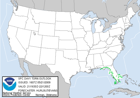
Although we anticipate working through a number of archive cases on all 4 projects today, we have decided to jump on the opportunity for a real-time IOP in Florida, where ongoing thunderstorms and others later this afternoon will carry threats for tornadoes and marginally severe hail.

Day 1 Tornado Probabilities Issued 1630Z on May 21, 2009

The team of Mike and Rob will take on this IOP once the HWT becomes initialized to the Tampa Bay CWA.  On the other side of the room, the team of Les and Matthew will work with the CASA project leads, and our guest, Ed Cravens, the emergency manager for McClain County, Oklahoma.  Ed’s presence this afternoon really represents an effort to bring end users into the research and development phase of new weather-related technologies.  The CASA group will perform warning operations using an archived data set.

Patrick Burke (EWP Weekly Coordinator, 18-22 May 2009)

Tags: None

Summary – 20 May 2009

The day began with an archived LMA event.  We then had a successful MRMS IOP in the Cheyenne, WY, and North Platte, NE, CWAs.  We certainly made the most of what was a marginal severe weather setup in the most marginal of weeks!  Forecasters spent some time learning the MRMS products, and then began to issue warnings.  Severe warnings were scattered initially.  Eventually, one multicell formed a cold pool and propagated forward, maintaining a severe weather threat all along its path as it approached the KLNX radar. There was plenty of discussion of MRMS products in relation to wind and hail threats, and updraft strength. Operations are winding down as of 8:25 pm CDT, and we will hold an end of day discussion to gather forecaster feedback.

All of this week’s forecasters advocate intense use of base data in warning decision making.  Mike says “We are overloaded with derived radar products.  Just give me the base data, and a better understanding of the environment (to improve warning decision making).”  Others agree that environmental data is key to warning decision making, but they also point out that there may be some tasks that algorithms can perform very well, thus freeing the human forecaster to tackle other problems.  The group also discussed certain scenarios in which algorithms can aide the forecaster during low staffing or broad geographical outbreaks.  In such cases, Matthew would use algorithms to rank storms that need further investigation in the base data.  Les and Rob particularly like the LMA and lightning trend data, as it is “Base data of a different kind.”  The forecasters, as a whole, liked the trend graphs for all types of data.  That was the most useful function of the data in Google Earth.  The group noted several areas, however, where the Google Earth data needs improving.  There is no time stamp, images are smoothed, and there is no cursor readout.  They would like the color tables to be synced to the respective products with which they were intended to be used, rather than requiring the forecaster to click on a product and then click on an appropriate color curve.  The color curves also need to be consistent across platforms so that the data looks the same on Google Earth as it does on D2D/AWIPS.  In its current state, forecasters feel the images in Google Earth are better suited to verification efforts by mapping MESH and rotation tracks to GIS data, than they are suited to warning decision making.  Within AWIPS, forecasters looked at MESH swaths and current MESH, as well as height of the 50 dbZ reflectivity.  These things were used most often to assess hail and updraft strength.  As noted in another post, forecasters would like to see height products for 60 dbZ, and they did not seem to find much use for 18 and 30 dbZ.

Patrick Burke (EWP Weekly Coordinator, 18-22 May 2009)

Tags: None

Live Blog – 20 May 2009 (8:15 pm) – Storm Hand Off

Mike and Matthew passed their severe storm off to Rob and Les when it crossed our arbitrary sector boundary at the longitude of KLNX.  Rob and Les have continued warnings, and there was some debate as to what hail size should be mentioned in the new warning.  The radar presentation had become quite impressive around 8 pm CDT.  MESH indicated 2.88 inch diameter hail.  Les argued for baseball size hail in the warning.  Arthur and Patrick argued for something closer to 2 inch, based on reports (phone calls from the HWT and Local Storm Reports from CYS and LBF) throughout the evening that have been consistently lower than the MESH values.  The reports have also indicated very heavy rain.  The storm does not have a very impressive mid level mesocyclone, and Les agreed that was a good reason to undercut MESH in the warning.  Rob issued the warning, mentioning golf balls.  The largest hail reported today has been 1 inch.

Patrick Burke (EWP Weekly Coordinator, 18-22 May 2009)

Tags: None

Live Blog – 20 May 2009 (7:40 pm) – Watching boundary & storm interactions

The storm of greatest interest continues to be this north-south elongated cell that is straddling the frontal zone as it moves east toward the KLNX radar.  The updrafts have remained near but just behind the leading edge of outflow.  The outflow boundary is overtaking the cold front, and a more notable fine line that represents outflow from other cells farther northeast.  The forecasters have seen one or two small circulations form and dissipate at the boundary intersections.  There is some debate as to whether the high LCLs would allow for non-supercell tornadoes in this situation.  Mike and Matthew have continue to issue severe thunderstorm warnings for this cell.  Other cells to the east have remained non-severe in Les and Rob’s opinions, though they would continue Special Weather Statements.

Patrick Burke (EWP Weekly Coordinator, 18-22 May 2009)

Tags: None

Live Blog – 20 May 2009 (6:54 pm) – Legacy Hail Algorithm Environmental Parameters

Rob has been looking at the Legacy Hail Algorithm on AWIPS to compare with the experimental products.  He discovered that the locally run Legacy Algorithm is not synced to updated environmental data.  The update time is labeled as several years ago.  So that will need to be corrected in the future.

Patrick Burke (EWP Weekly Coordinator, 18-22 May 2009)

Tags: None

Live Blog – 20 May 2009 (6:42 pm) – Convective Mode Update

Our teams are working in the North Platte CWA.  They have sectorized, with Matthew and Mike taking storms west of the longitude of the radar, and Rob and Les taking those to the east.  Matthew/Mike have issued one warning, using base data in conjunction with MESH, POSH, and max height of 50 dbZ.  Their cell is elongated and straddling the east to west oriented fontal zone.  Rob and Les have observed numerous microbursts near the radar.  They feel the storms are not severe, but if they had the option – they would issue a Special Weather Statement.

Patrick Burke (EWP Weekly Coordinator, 18-22 May 2009)
Tags: None