Metwatch for Wilmington DSS event

Metwatch for Wilmington NC started with modified NUCAPS soundings and a comparison with NAM BUFKIT profiles:

Looking at 700mb temperatures, BUFKIT has about 8C for that layer, and here is the gridded NUCAPS 700mb temperature layer. Note: not a lot of advection noted at 700mb, with low level dry advection (not shown)

Watching this cell just outside the CWA pulse and then fall apart…PWV3 never exceeds 4% with this pulse. LightingCast also showed a rapid drop in probabilities.

Not much happened today, but just along the coast was this little area of enhanced CAPE (3000j/kg)…so you’re saying there’s a chance…

Comparison between parallax corrected and uncorrected lightning cast. You can see the image above and to the right (corrected) has some higher percentages getting into the 20 mi range ring compared to the non corrected data which just has the 25% grazing the 20 mi range ring. Having the corrected data could be more beneficial to providing DSS support.

– Mr. Bean

– Noctilucent

LBF HWT Blog Day 4

We didn’t have too many storms occur during operations today, but that allowed us to be able to focus more on CI.

LightningCast for CI

Was able to use LightningCast for convective initiation today as LBF was waiting for storms to fire back up for the afternoon and evening. Initially we were thinking storms would form first over the southern portion of the CWA based off of modeled convective parameters but at 2101Z, a 25% chance of lightning popped up via LC for the north-central portion of the forecast area. This 25% contour appeared a few minutes before radar reflectivity started showing up for the same area. Seeing even the 10% contour show up earlier on, clued me into the fact that we needed to shift our focus further north than we originally thought. These storms seemed to be forming along a shear gradient and weak boundary.
Of note, I am using the parallax corrected LC.
LC, GLM FED, and DCPD at 2100Z
LBF radar at 2109Z
By 2116Z, both GLM and ENTLN showed the first flash of lightning, allowing for around 15 minutes of lead time off of the 25% contour.
For comparison, these storms were forming ahead of the highest PHS CAPE and ahead of any of its stronger gradients.
21Z:
22Z:
As our day was winding down, LC continued to indicate areas to watch before it showed up on radar, but I did not grab additional images.

NUCAPS:

Tried to compare NUCAPS soundings today as we did have an overlap, but unfortunately ran into technical issues within my CAVE so was not able to do much with it. Another limiting factor was that the only “green” soundings from Aqua within our CWA fell within the far western scans which we were told by one of the developers they would next expect good data from, being on the limb. But for comparison, here are Aqua (1911Z) and NOAA-20 (1953Z) sounding from points NW of North Platte.
Points selected were both NW of the town of North Platte, circled below. The NE point of the two is Aqua and SW point is NOAA-20
– Matador

Differences in Prob Severe v2 vs v3

Some significant differences in probabilities for v2 vs v3. Noted on this storm in northern New Mexico. Not quite sure the reasoning for this large discrepancy.

Storm ID: 346478 in Northern New Mexico June 9, 2022.

Notable Differences in ProbSevere in the time series.

Storms going up right along forecasted boundary from PHS CAPE

Storms developing in Prowers County in southeastern Colorado.

– David Spritz

ProbWind and ProbTor Performance

ProbSevere May Have Caught a Missed Severe Wind Event

The ProbSevere v3 drew attention to a cell near Bloomington, IN on the afternoon of June 8th. Specifically it was drawing attention to the wind threat with a high ProbWind percentage reaching 50% to 60%. However, radar interrogation was only initially yielding velocity of 30-40kts on the inbound side of the cell, sub-severe but certainly SPS worthy. There were a few scans yielding up to 45kts as well. So initially there was a little wondering why there was higher ProbWind percentages. Quick realization of the storm track being perpendicular to the radar beam could explain the lower velocity signatures here. Knowing this, ProbSevere and its ProbWind portion was drawing attention to a scenario that otherwise may have been missed if only looking at velocity data and not realizing the storm track relative to the radar beam.
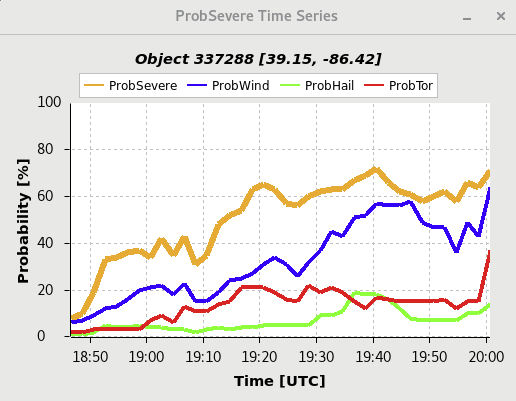
ProbSevere v3 of “Bloomington Cell”

STP went up at 20Z coincident with new SPC mesoanalysis.

ProbSevere v3 readouts of “Bloomington Cell” at 1940Z

KIND Velocity signature of the “Bloomington Cell” @ 1941Z

ProbTOR Missed a Likely Tornado Event – First Example

At 2005Z the KIND radar showed a solid and persistent tornado signature on a cell near Shelbyville, IN. To go along with this in the overall outlook for the day was an MD highlighting the tornado risk and a Tornado Watch that included the southern half of IN. However, the ProbTor parameter did not tick up in response to the tornado signature on radar. The observed uptick at 2000Z, coincided with the intake of the new SPC mesoanalysis data that ProbSevere v3 ingests as described by the product’s providers. Even still, this uptick was small only amounting to a ~5% increase.
ProbTor only peaking at ~15%
 
The second image below may explain some of this away, showing that two individual cells were coalesced into a single storm identified by ProbSevere v3. These two cells were relatively close to each other, so much so that they did appear as one on MRMS data. However, the third image of SRM and V show the tornado signature associated with the northern cell. This combination, with the southern cell having a much lower tornado potential and being ingested by the northern cell may have played a role in lowering the overall ProbTor percentage.
ProbSevere v3 showing that cell being grouped with another to its south, could this have inhibited the increase in ProbTor?
 
SRM (left) and V (right) showing the TOR signature with this cell.
 
Multiple LSRs for wind damage were observed from this event, with a “tornado possible” added to the remarks.

The PHS SigTOR parameter also further supported the tornado risk during the 2000Z hour. The image below shows the PHS SigTOR parameter at 2000Z with ProbTOR percentages overlaid on top. The cell which produced the likely tornado east of Shelbyville, IN is sampled in the image with the ProbTOR only at 9%.

PHS SigTOR parameter pegging the area that produced a TOR. The cell highlighted with ProbTor readout produced the Tornado Warning referenced earlier.

ProbTOR Missed a Likely Tornado Event – Second Example

From roughly 2130Z to 2200Z, a supercell passing west to east through west-central OH showed a persistent meso signature as seen from the KILN radar in Wilmington, OH. This signature eventually depicted gate-to-gate shear and tornado warnings were issued for this cell. The same ongoing Tornado Watch from the prior example also covered this same region. Image three also shows the PHS SigTOR Parameter showing higher tornado potential in the region, although not directly overlaid with where the Tipp City cell was. However, the ProbTor parameter of ProbSevere v3 did not show a corresponding jump in tornado potential. Unlike the prior example which showed the ProbSevere v3 grabbing a second much weaker cell with the tornado producing cell, this was a discrete cell with no merger occurring.

Highlighted in the Tornado Warning issued by the Wilmington, OH office, was a tornado debris signature. The KDAY metar located just south of Tipp City also included “tornado” in the remarks signature, shown in image four.

KILN SRM and V showing tornado signature near Tipp City.

Time series of ProbSevere with persistently low ProbTor for tornado warned storm west of Tipp City.

PHS SigTOR Parameter highlighting higher tornado potential in the region with overlaid ProbSevere – ProbTor percentage for tornado warned cell by Tipp City.

The KDAY metar showed “tornado” in the remarks section for the cell passing through Tipp City.

– Trip

PHS, NUCAPS, Optical Flow, Prob Severe Fun

PHS and NUCAPS

Today worked out well with PHS and NUCAPS. NUCAPS data came in shortly after opening up our work stations. We decided to compare the output between PHS, NUCAPS, and SPC mesoscale analysis. The variable that we chose was surface CAPE.
They all seemed to match up well highlighting the higher instability to the south that would gradually  push north this afternoon. It was definitely a confidence builder in each product to see the agreement between them.

Optical Flow

We also decided to compare the Optical Flow winds to SPC mesoscale analysis. Once storms developed a bit more, you can pick out a slight directional divergence signal in the flow. Looking at SPC mesoscale analysis there is also directional divergence is present in the mesoscale analysis.
Overall looking at these two examples, using these tools together can be a way to verify information and give the meteorologist more confidence (or less) in a specific product to help them with forecasts, DSS, and warning operations.

Prob Severe

We were able to compare Prob Severe V3 to the time when there was an observed report and when the new tornado warning came with a radar observed tag due to a CC drop. The first image is when there was a twitter report of a tornado around 2142Z in SE Darke county.

At 2144Z the Prob Severe V2 tornado jumped to 21% while V3 only went to 6%.

The next image below is when the radar confirmed tornado was reported.
– Noctilucent & Matador

PHS CAPE localized maximum compared with storms developing in the area

PHS CAPE values increase from north to south over Fort Stockton. This correlated well with RAP mesoanalyzed SB CAPE on SPC webpage. Storms actively going up along this gradient as an outflow boundary pushed south during the early afternoon from overnight convection over Oklahoma.

PHS CAPE 18Z 1 hour forecast for 19Z

PHS CAPE 18Z 2 hour forecast for 20Z.

Storms developing over Fort Stockton via Day Cloud Phase Distinction on GOES 17 Mesosector

We showed above that the north side of the outflow would contain more instability – which is directly related to the moisture from the morning MCS outflow. The Gridded NUCAPS provides additional insight using the 850mb moisture fields from both AQUA and NOAA20 respectively – validating our hypothesis.

We double checked since there was a dust advisory/dust in the forecast and yes – Dust

Don’t warn if pop = 0

Convection was skirting the northeast portion of the CWA so we’ll use the recent pass of NOAA-20 to view the potential for convection redevelopment to the west and affecting the forecast in our CWA. Here are the Modified NUCAPS soundings:

The top image is for the sounding in Jones county, below is Scurry – which shows a capping inversion still in place.

Storm Motion

Weak winds aloft and throughout the atmosphere have contributed to very little in the way of storm motion. Hence, locally heavy rainfall may begin to evolve, even over an area that has received very little rainfall in the last 6 months.

Optical Flow Winds in the 200-100 mb level.

Day Cloud Phase valid 2041Z.

Day Cloud Phase valid 2141Z.

PHS depicts this plume of moisture and associated instability will back into New Mexico this evening. Could it play a part in tomorrow’s severe weather risk?

Here is what happened at El Paso when the front backed into the area – Dewpoint jumped from 30F to 50F

– David Spritz

– Mr. Bean

ILN HWT Blog Day 3

NUCAPS

Did finally get a chance to check out NUCAPS for today’s case as the timing and location of the data was more compatible. It was good info ahead of the storms as it showed the low LCL values (mainly noticed in the modified soundings), below 1000 ft which is what you want to see for potential tornadoes. Overall, liked getting to dig into the NUCAP soundings, but given the finicky timing and data quality, it’s not something I could use on a regular basis for warning operations. Would be better suited for short term forecasting or possibly as the mesoanalyst.

GLM & LightningCast

For GLM, I set the max value at 130. I originally set it to 65 as I had been using in the high plains the past few days, but for these midwest storms it seemed too sensitive. 130 was a good value for today, likely because of the larger and more numerous storms than I dealt with today versus the previous days.
Also tried out the parallax corrected LightningCast today. Liked that it gave a more accurate location when using it for a specific location such as today’s DSS event. While it was made to pair with radar, it was still useful when using it with satellite products – just had to take a few seconds to make the mental adjustments at the beginning.

PHS

Prior to entering the ILN CWA, the PHS STP showed an area of high STP values in and near Rush County, Indiana. The actual IND office did issue a tor warning for this area at 4 PM ET.
Over time, I did notice that for STP, really just the current hour and the next couple of hours were useful. Jumping to 3 or 4 hours ahead it seemed that the data was missing for areas I expected to see higher values. Once the next run came in and I went back and looked, the data was much better. For an example below, there was a vast difference for 21Z between the 18Z run and the 20Z run where the 18Z run for that time did not seem realistic but the 20Z run was more what I expected to see.
08.18 run for 21Z

ProbSevere

After talking with one of the ProbSevere people, was able to learn that the threshold for ProbTor is lower than that for Wind or Hail. For training purposes, it would be good to include this information to give a mental threshold for forecasters, such as an ongoing tornado would likely see a max of around 60% for ProbTor. It makes sense that the probs would be lower for tors just as they are for SPC outlooks where the tor percentages are also lower than that for wind or hail.
– Matador

GLM maxFED Comparisons


NUCAPS Sounding (IND 06/08/2022 2019 UTC)

Lowering maxFED values effectively highlights the area of strongest thunderstorm activity as seen in this example. This makes the strongest two thunderstorms (circled) more distinguishable from other thunderstorms, especially on the northern circled thunderstorm. It should be noted that this may be even more effective during the initiation to nearing maturity stages. Once a storm reaches full maturity, FED signal may be much higher.

– 2%hatched

Comparing NUCAPS Soundings along Warm Front Passage

NUCAPS Sounding (1832 UTC)

NUCAPS Modified Sounding (1832 UTC)

NUCAPS and NUCAPS Modified soundings displayed were along a warm frontal passage lifting south to north across southern Indiana. The modified NUCAPS sounding provided a more realistic depiction of the environment with higher levels of instability (CAPE and DCAPE). Furthermore, the LCL values represented in the modified sounding were lower; depicting an environment more favorable for tornadoes along the warm front.

– 2%hatched

Two Storms GOES 16 v 17

Being on the western edge in the North Platte County Warning area we did a comparison versus GOES 16 and 17 with the GLM Flash Extent Density. At first there wasn’t much of a difference, but when storms started to ramp up more and we had a decent eastern and western storm there was a difference.

As you can see our eastern storm shows up better on GOES 16 and not as good on GOES 17. Meanwhile the western storm there is a much greater difference in the Flash Extent Density (and Total Optical Energy) on GOES 17. This matches with what was stated at the initial discussion this morning that GOES 17 may work better with western storms.

-Noctilucent