ProbSevere Helped to Hold Off On TOR Warning

Here is an example of a long lived supercell where the trends are very important to monitor. Notice the uptick in Prob TOR but then backed off.  AZShear has been impressive for several volume scans.  Prob TOR trends kept me from issuing a TOR warning, and provides some security in not issuing a warning along with other products.  As a side note,  it would be nice to sample some sort of maximum wind gust product, much like we get from MESH with the estimated max hail size.

ZDR_Arcophile

Shields Disengaged

The cap finally broke over Houston’s CWA and we now have some storms to look at. Hopefully, these storms will hold together and become better organized so we can look at other products today. Given that CAPE is generally around 3000-4000 J/kg it shouldn’t be a problem, but we are on borrowed time.

Tags: None

Warning Decision Influenced by ProbSevere

Since our shields have been engaged all afternoon I decided to look at a storm to our east. Below are a series of reflectivity images from the three lowest scans (0.5, 0.9, and 1.3)…

I won’t lie to you, if I were back in my home CWA I would have probably issued a SVR based on these scans, but I decided to hold off on issuing one today until we got close to 90% probabilities to see how ProbSevere did.  So what did ProbSevere show? Here is a sample of various MRMS products overlaid with ProbSevere contours…

And here is a time series for this storm looked like…

These trends looked pretty impressive, with ProbHail peaking around 86%. The increase in probabilities make sense, with MESH peaking around 1.4 in (below in purple).

We will have to wait and see if my decision to not issue a SVR based on a ProbHail is justified, but based on the lack of any reports, I think it may have been a good call.

UPDATE…The storm in question got one severe hail report.

Prob Severe New Cell Detection

Here’s an example where Prob Severe was slow to detect a new cell on the southwest flank, which is a fairly typical severe scenario.  And when it finally does detect the cell, it is combined with the already large conglomeration of convection.

ZDR_Arcophile

Wherefore art thou Convection?

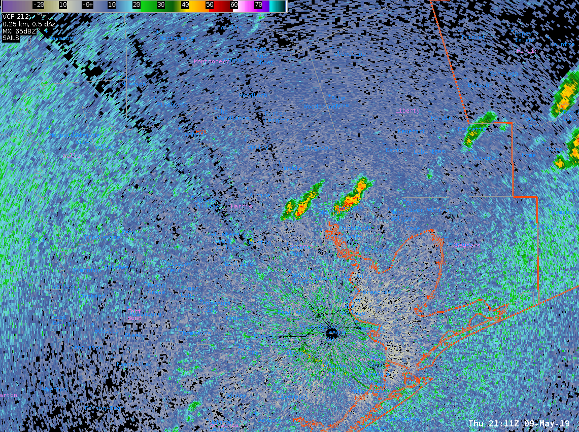
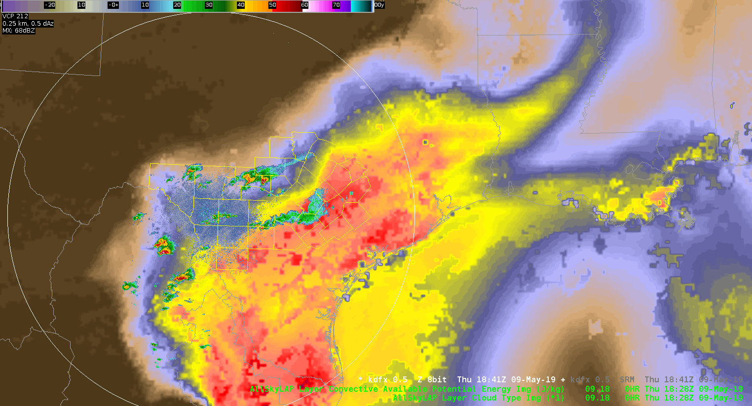
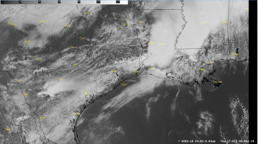
Two hours in and we are STILLLLLL waiting for convection to fire in the KHGX CWA.  Front is stalled across the northern quarter of the CWA and the sea breeze has pushed inland from the southeast.  Come on storms…really?

O.K., why no convection?  KLCH launched a sounding at 17Z which looked like this from GOES-E (why this is important in a bit):

Congrats to Lake Charles getting a special sounding off before those storms arrived!  This is what the lowest half of the sounding looked like with boundary layer conditions guessed from the near the center of Houston’s CWA at KTME (Houston Executive Airport):

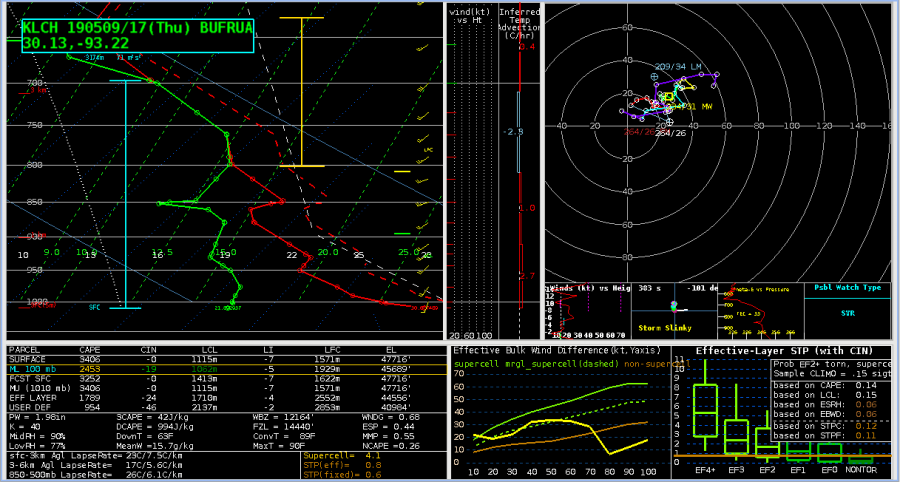
No Cap, ~2500 J/KG MLCAPE, surface moisture isn’t mixing out too much….so, where are the storms?

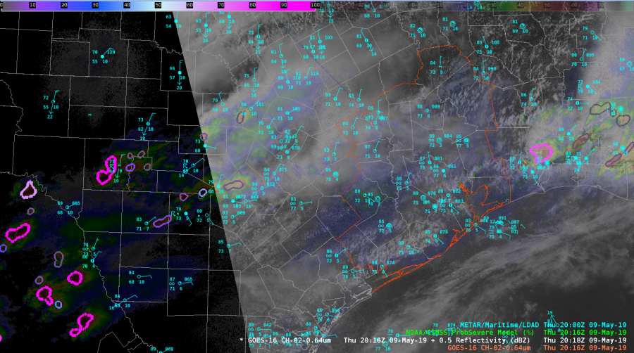
Let’s take a look at a NUCAPS sounding taken from this point almost an hour after the KLCH sounding:

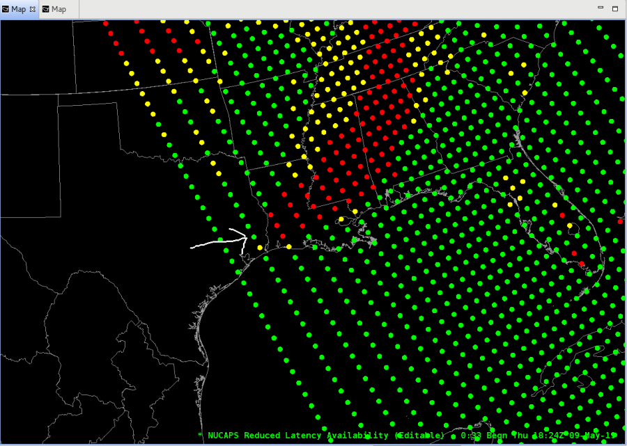
I know you are going to ask…why not the next closest dot further west?  Well, it is on the edge of the instrument swath and that has a whole host of problems.  Second thing is that the soundings along the edge looked…wonky…compared to the next row further east.  The sounding at that point, again modifying the surface conditions for KTME (88/75 T/Td):

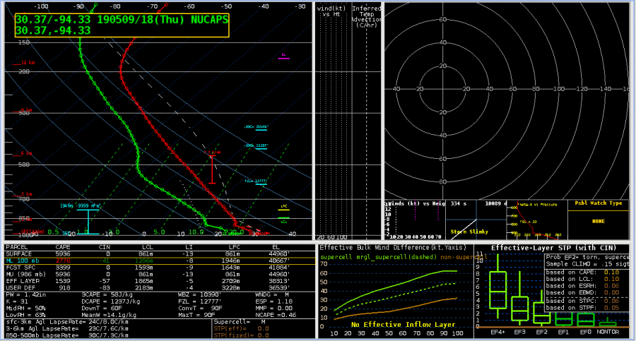
Things that make you go; hmmmm.  Using the MLCAPE profile, the NUCAPS sounding shows that there probably is a residual EML behind the departing storms that the KLCH didn’t capture ahead of the storms.  That may be just enough to keep the atmosphere capped and storms at bay.  There isn’t much of a cap, so hope continues we will get convection over the KHGX CWA.

NUCAPS sounding profiles – thumbs up for helping figure out what is going on.  And get more polar orbiters up and going so we can have more than two soundings per day…preferably on different orbital inclinations for better spatial coverage. Please?

-Dusty

Prob Severe Combines Discrete Cells

Here is a prime example of two warned storms with distinct updrafts that were combined due to their close proximity to each other. As opposed to being slow to recognize splitting cells, ProbSevere actually took two established discrete cells with separate updrafts and combined them.

ZDR_Arcophile


MRMS and ProbSevere – SAD Match made in the EWP

Wanting a good way to keep up on the environment while also monitoring for storm development?  Give this combo a tryout (and note, I totally stole this from another EWP participant this week.  Why?  Because it works!)

Top left: MRMS Reflectivity at Lowest Altitude (RALA), Reflectivity at -20C, ProbSevere All
Top right: MRMS Maximum EstimatedSize of Hail (MESH), MRMS 60 Minute Hail Tracks (50%             Alpha), ProbHail
Bottom left: MRMS Vertically Integrated Liquid (VIL), MRMS Vertically Integrated Ice (VII,                    100%), ProbWind
Bottom Right: MRMS 0-2km Merged Azimuth Shear, MRMS 0-2km Rotation Tracks 60-minute          accumulation (35% Alpha), ProbTor

The nice thing with this display is that you can quickly sample any of the objects to get details on what is going on with any given storm to keep situational awareness.

Yeah, that’s a lot of text on the 4-panel but each one is specific to the threat in the pane and the ProbSevere (top left) is a bit of everything mixed in.  So far, it has worked with all convective modes we’ve seen so far in the Testbed.

-Dusty


All Sky CAPE dropout between time steps

I would like to be able to load ALL-Sky LAP Data Type and CAPE on top of radar data. An unfortunate annoyance is that if the time stamp is too far from the radar product time stamp, the All-Sky products completely disappear,  and in fact, if too far away, it won’t load at all. I would like the ability for the latest All-Sky products to display, despite the time lags between the the two. In other words, I would rather have the latest “old” data from All-Sky rather than display nothing.

ZDR_Arcophile


Comparison of ATPW and Blended TPW

I was finally able to take a look the ATPW (top left) and compare it with the operational blended TPW (top right). My first impression was that both products show similar large scale patterns with a large plume of moisture extending from the Gulf of Mexico into the Ohio River Valley. The ATPW also tends to show a little more detail in the moisture field compared to the blended TPW.

At 15Z ATPW shows an area of lower moisture over the Texas Gulf coast which is sort of fills in by 17Z, likely due to upstream moisture being advected into the area. In contrast, this moisture is continuously present in the blended TPW. ATPW generally had PWATs around 1.5 in, while the blended TPW had PWATs around 1.7-1.8 in. In contrast, 12Z RAOBs along the coast had PWATs that ranged from 1.6 inches at KBRO to around 1.8 at KLCH. These values seems to match better with the blended TPW product. I suspect that the upstream convection over Louisiana and lingering clouds over the coast impacted the ATPW that was corrected in the blended TPW.

Update…Below is a loop of the LAP All Sky T PW. This loop shows a similar pattern to the ATPW and Blended TPW with a large are of gulf moisture moving into the Ohio River Valley. It is interesting/good to see that the LAP All Sky TPW is picked up on the sea breeze kicking in along the Gulf Coast. Despite the subtle differences among the three products the fact that they show similar patterns gives increase confidences that we will likely see a large area of flash flooding across portions of the south if storms are able to develop.

Increasing trend in Prob Severe products

Between 1840Z and 1844Z, the ProbWind increased from an already high level of 85% to 84% as a bowing segment developed and moved into northern Brazos and Madison Counties.  Also of small note, ProbHail increased from 15% to 29%, and ProbTor increased from 17% to 20%.


ZDR_Arcophile