OUN-WRF 18 May 2011

2355Z Update: Although OUN-WRF continues to generate well defined supercells east of dryline across central Oklahoma, confidence very low due to cooling boundary layer. Dryline is just beginning a shift westward so will need to watch it for just a little while longer. 19/0100Z.

OUN-WRF, since 18z run, has consistently shown signal for convective development just west of OKC metro. Embedded supercells, with southern flank 2-5km updraft helicities 200+ m2/s2 and deviant motions. 20-21z runs want to bring supercell through Norman 23-2330z with southern flank of this storm shifting south and turning right toward Ada. Model has been too eager to develop convection, but depiction of central Oklahoma impacts continues.

Brief convective element over western Major county and weak echoes across southwest Oklahoma from wildfire. Will continue to monitor CI products and trends of ounwrf.  kbrown 2215z

Tags: None

Widespread cumulus fields forming across central eastern VA and UAHCI products capturing this much better than CIMMS in this case, which is a very moist, weakly unstable, but uncapped environment (almost tropical). While most new CI IDs are very scattered to isold in nature, now beginning to see some banding or clustering, which actually matches very well with at least one 4km WRF (12Z run for SPC…see second image above), and will be watching to see if the IDing of this banding of CI zones within otherwise wideapread cu field helps to identify where stronger storms could soon be forming in this kind of environment.

Steve Keighton

12 May 2011 AFD update

CI is occurring within area of MLCAPE aoa 2000 J/kg along cold front extending from just east of KBVO to just north of KADM.  Cells initally were discreet but have been merging/growing into short multicell segments.  Additional isold convection is developing within broad warm sector over northeastern TX northeast into Pushmataha and LeFlore counties. Multicellular convection in this area looks enfeebled both visually and on radar.  Weak low and mid level SR flow indicates an evolution into a linear mode.  Given the amount of instability present along with mid tropospheric jet streak approaching area expect hail to 2 cm and wind gusts to 30 m/s.

Previous forecast had CI in a broad zone extending from near KJLN south to KMEZ.  Mesoanalysis showed a persistent area of lower CAPE in this region, owing to increased cloudiness and inhibited insolation.  Convection in this area appears shallow and unelectrified.

19Z run of the oun-wrf overconvected over southeastern OK and did not represent reality.  The 20z run, however, is sampling the CI and hopefully will provide a better solution.

Blair/Curran

Tags: None

12 May 2011 Morning Forecast Discussion

Initial thoughts focus on the Tulsa (TSA) as well as the Springfield (SGF) and Little Rock (LZK) CWAs for convective initiation and storm maturity. Latest visible satellite imagery depicts congested cumulus field over southeast Oklahoma in response to continued low-level moisture transport and broad ascent with analyzed speed maximum across northeast Texas.

  • Watching two potential scenarios unfold late this morning into the afternoon hours. First, monitoring broad cu field over the next several hours for initial convective development over eastern Oklahoma or western Arkansas as further low-level destabilization transpires and increasing deep layer shear arrives across the area. Model guidance suggests robust activity maturing over northeast OK into northwest Arkansas by early/mid afternoon, and therefore watching the TSA/LZK CWAs.
  • To the west, a more conditional scenario exists along the cold front during the afternoon from Ardmore to Tulsa. Clearing has been noted ahead of this boundary from Graham, TX to Duncan, OK. Stratus deck to the northeast of the corridor appears to be thinning along I-44. Will have to also monitor this area later this afternoon across the TSA CWA for additional robust activity.

Main severe weather threats will likely be large hail up to golfball size and damaging winds in excess of 60 mph with well-organized multicell storms or a few supercells. Tornado threat appears low today with marginal low-level shear within the 0-1 km layer. However, any unresolved storm-scale boundaries from early morning convection within the warm sector of far eastern Oklahoma or western Arkansas may locally enhance isolated tornado threat.

Blair/Curren

Tags: None

11 May 2011: Initial Area Forecast Discussion

AREA FORECAST DISCUSSION

  • A closed low will move from the Four Corners area to the north-northeast through the afternoon and evening.  A short wave trough rounding the base of the closed low will track from southern NM into the OK/TX panhandles this afternoon.  The largest height falls are forecast from the panhandles into western KS, with weaker forcing extending farther east.
  • RUC forecasts MLCAPE in the 2000-3000 J/kg range east of the dryline.  Sufficient deep layer shear to support severe thunderstorm development should be in place by early afternoon.  Via a combination of surface heating and increasing large scale forcing for lift, the cap is expected to weaken enough to allow for thunderstorm formation.
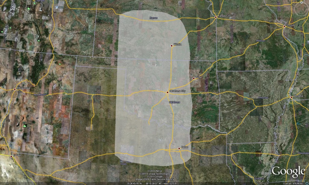
  • Our area of focus was chosen considering not only the potential for severe convective storms, but also the availability of lightning data and OUN WRF data over Oklahoma.
  • Afternoon thunderstorm development is conditional, depending to a large extent on the evolution of ongoing thunderstorms over central OK and north TX.  Further thunderstorms developing in between these two areas could decrease instability by limiting moisture advection and surface heating.
  • Top four choices for CWAs of focus:
  1. OUN
  2. ICT
  3. DDC
  4. FWD

Billings/Taylor/Vincent

Tags: None

2011-05-10: Area Forecast Update

Update to previous discussion…

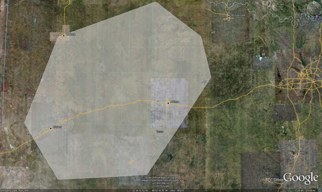
Biggest change resides in surface wind field already responding to upstream pressure falls, with backing winds across a large portion of the domain. In contrast, deeper moisture discontinuity gradient resides through Sweetwater to Dryden as of early this afternoon. Recent satellite imagery depicts high-based cu developing within dry air in proximity of weak surface convergence. Low probability of this initial activity persisting due to concerns with very high T/Td spreads, via cold pool dominance. Outside of this area, skies continue to clear, with the main clearing line stretching from CDS to DRT. At the present time, moisture will need to stream NWward in order to establish severe weather threat. Short range forecast guidance continues to indicate a rapid transport of surface moisture between 00-03z and likewise shows a weak signal of convective initiation upon retreating dryline approximately 23-02z, generally east of Midland, TX. Forecast consensus considers this scenario low-confidence. However, if convection does develop in this region, environment supports robust development with conditions favorable for initial mode of supercellular activity. Models trend for upscale growth as low-level jet increases early this evening as convection translates east or northeastward over the remainder of MAF and SJT CWAs.

Blair/Curran/Billings/Taylor/Vincent

Tags: None

2011-05-10: Initial Area Forecast Discussion

  • Focus today through this evening over the MAF and SJT CWAs.
  • Ongoing convection initiated on lead wave this morning extending from the western Hill Country northeast into Oklahoma complicating matters.
  • Dryline initially from 30 W KCDS south to near KSWW then southwest to KFST will mix/advect west about 30-40 miles before stalling and retreating westward in advance of shortwave rounding the base of the longwave trough over the western CONUS.
  • OUN WRF indicates weak convection firing along and ahead of dryline/differential heating boundary from near KSNK south to near KJCT.
  • Initial activity should move northeast…high res models suggest activity will decay a bit after 23z.
  • Well defined wave on WV and short term model guidance expected to move out of northern Mexico after 00z.
  • Convergence along retreating dryline with MLCAPEs over 2500 J/kg.
  • RUC SBCAPE indicates significant increase in instability retreating west with the dryline after 00z.
  • Another round of CI expected to occur between 00z and 03z invof MAF.  Deep moisture over western Hill Country southeast should not mix much owing to cloud cover and attenuated insolation.
  • NAM and HRRR hints at robust convection between MAF and SJT around sunset.
  • Potential for supercellular structure with large hail (aoa baseballs) with second round.  Tornado and high wind threat somewhat less owing to stabilization of PBL.

Tags: None

Week 1 Underway

After the typical culmination of late night hours and technology wrestling matches, the 2011 edition of the Experimental Warning Program’s spring experiment, or EWP2011, gets underway today.  We want to welcome our first set of visiting forecasters:  Jerilyn Billings (WFO Wichita, KS), Scott Blair (WFO Topeka, KS), Brian Curran (WFO Midland, TX), Andy Taylor (WFO Norman, OK), and Brandon Vincent (WFO, Raleigh, NC).

We are trying a few new things this year:

1)  Monday is our dedicated training and orientation day.  In the past, we’ve crammed in both training, orientation, and real-time operations on the first days of each operational week, and have felt rushed and in some cases, the forecasters felt unprepared.  So we’ve expanded our time dedicated toward our training sessions, and turned the last few hours of the shift into a hands-on get acquainted with the AWIPS software and experimental products session.  In addition, we’ve moved our Monday shift back 3 hours (10a-6p) so that our visitors can get started right away on their first day.

2)  Tuesday, Wednesday, and Thursday are our only real-time operational shifts.  The entire days will be devoted to real-time operations, instead of wrapping up unfinished training from Monday.

3)  Our real-time days now feature two overlapping shifts.  In an effort to a) emulate the forecast – nowcast – warning decision processes in a WFO, and b) start bridging the gap between the EWP and the Experimental Forecast Program (EFP) of the HWT, we’ve added an early shift.  We are splitting our visiting forecasters into two groups, and each group will have opportunities to work both shifts.  The early shift runs from 9a-5p and the late shift is our usual 1p-9p.  The early shift will issue a morning Area Forecast Discussion (AFD).  Between 1p-5p, both shifts will overlap and collaborate on an update to the AFD, as well as being the process of monitoring convective initiation (CI), issuing nowcasts, and eventually warnings, all weather dependent on the forecast/warning area chosen for the day.

4)  The EWP and EFP will conduct a joint map discussion at 1pm on the real-time operations days.  The EWP will inform the EFP about the previous day’s events, and the EFP and our morning EWP shift will help inform the EWP on the likely areas of warning operations for the afternoon and evening.

Watch here for daily outlooks, live blogging during operations, daily summaries, and an end-of-week summary for the next 5 weeks.  Note that we take a holiday the entire week of Memorial Day.

Greg Stumpf, EWP2011 Operations Coordinator

Tags: None

EWP2011 Underway…

We are in the process of preparing for EWP2011.  There will be three primary projects geared toward WFO applications, 1) evaluation of 3DVAR multi-radar real-time data assimilation fields being developed for the Warn-On-Forecast initiative, 2)  evaluation of multiple CONUS GOES-R convective applications, including pseudo-geostationary lightning mapper products when operations are expected within the Lightning Mapping Array domains (OK, AL, DC, FL), and 3) evaluation of model performance and forecast utility of the OUN WRF when operations are expected in the Southern Plains.  We will be conducting EWP2011 for four weeks total (Monday – Friday), from 9 May through 10 June (Memorial Day week excluded).

New for this year, we will be attempting to do operations using the AWIPS2 platform.  We are still in the process of setting this up, and should know in the next few days whether or not it is going to be feasible for our specific requirements (experimental data set display and multi-WFO localization).

Finally, we are about to send out the official invitation to the NWS candidates we’ve selected to participate.  Now, we hope for no government shutdown, or a short shutdown if it happens.  Since most of the EWP scientists are not government employees, we can continue our work to prepare for EWP2011.  However, our NWS participants would not be able to travel in the event the government is shutdown during our test period.  Hopefully our elected officials do the right thing!

More details about EWP2011 will become available over the next few weeks.

Greg Stumpf, EWP2011 Operations Coordinator

Tags: None

The EWP2010 Thank You Post

This is this year’s EWP Thank You post, expressing our gratitude to the many participants of the Experimental Warning Program’s 2010 spring experiment. This year’s experiment was just as successful as the previous experiments, and it could not have been carried out without the hard work and long hours of our team of participants.  EWP2010 ended on a real high note this year, with experimental warning operations for the 17 June 2010 Minnesota and North Dakota outbreak.  All told, we issued 230 warnings and follow up statements on that one day alone, a record for EWP real-time operations.  And the software worked better than ever – of course with most bugs finally being fixed by the end of the experiment.  It seems like a century ago that we began operations on 12 April with the PARISE and CASA experiments.  All told, we have nine weeks of operations, 3 more weeks than any previous years.

The biggest expression of thanks goes to our two AWIPS/WES gurus “on loan” from the NWS Warning Decision Training Branch, Ben Baranowski and Darrel Kingfield.   Their tireless efforts helped keep the ship running through thick and thin.  Without their expertise to set up our simulated real-time NWS forecast office warning environment, localizable to any WFO in the country, as well as our WES archive cases, we simply wouldn’t have had an EWP2010.  Major kudos!

These scientists brought their expertise to the experiment to help guide live operations and playback of archive cases for each of the experiments:

For the Phased-Array Radar Innovative Sensing Experiment (PARISE), we’d like to thank the the principle scientists, Pamela Heinselman (NSSL) and Daphne LaDue (CIMMS), as well as their support team of Ric Adams, Rick Hluchan, Heather Lazrus, Heather Moser, Jennifer Newman, Dave Preignitz, and Adam Smith (all OU, CIMMS, and/or NSSL).

For the Collaborative Adaptive Sensing of the Atmosphere (CASA) experiment was again led by Brenda Phillips (U. Mass.), Jerry Brotzge (OU), and Ellen Bass (U. VA). In addition, we had help from Don Rude (U. VA), David Westbrook (U. Mass.), Cedar League (Univ. Colorado – Colorado Springs), Rachel Butterworth (OU), Brendan Hogan (U. VA), and Kevin Kloesel (OU).

For the Multi-Radar/Multi-Sensor (MRMS) application experiment, they included principle investigators Greg Stumpf (CIMMS/NWS/MDL) and Travis Smith (CIMMS/NSSL), with additional help from CIMMS/NSSL folks Kevin Manross, Kristin Kuhlman, Sarah Stough, and Steve Irwin.

For the GOES-R Proving Ground experimental warning activities, including the Pseudo- Geostationary Lightning Mapping (pglm) array experiment, our thanks go to principle scientists Chris Siewert (CIMMS/SPC) and Kristin Kuhlman (CIMMS/NSSL), along with Geoffrey Stano (NASA-Huntsville), Eric Bruning (Univ. Maryland/NESDIS), Wayne Feltz (UWM), Justin Sieglaff (UWM), Kris Bedka (UWM), Jason Brunner (UWM), Lee Cronce (UWM), Sarah Monette (UWM), Jordan Gerth (UWM), and Lindsay Richardson (CIMMS/NSSL).

Next, we’d like to thank the Weekly Coordinators for keeping operations on track during the experiment’s second phase (MRMS, GOES-R): Travis Smith, Kristin Kuhlman, Kevin Manross, and Greg Stumpf.

We had much IT help from Kevin Manross, Jeff Brogden, Charles Kerr, Villiappa Lakshmanan, Vicki Farmer, Karen Cooper, Paul Griffin,Brad Sagowitz, and Greg Stumpf.

The EWP leadership team of Travis Smith and David Andra, along with the other HWT management committee members (Steve Weiss, Jack Kain, Mike Foster, Russ Schneider, and Jeff Kimpel), and Stephan Smith, chief of the MDL Decision Assistance Branch, were instrumental in providing the necessary resources to make the EWP spring experiment happen.

Finally, we express a multitude of thanks to our National Weather Service and international operational meteorologists who traveled to Norman to participate as evaluators in this experiment (and we also thank their local and regional management for providing the personnel). They are:

Mark Bacon (WFO Wilmington, NC)

Jim Caruso (WFO Wichita, KS)

Jeff Cupo (FAA Training Center, Oklahoma City, OK)

Mike Scotten (WFO Memphis, TN)

Doug Cain (WFO Midland/Odessa, TX)

John Cockrell (WFO Amarillo, TX)

Andrea Lammers (WFO Louisville, KY)

Brian Montgomery (WFO Albany, NY)

Ernie Ostuno (WFO Grand Rapids, MI)

Jennifer Palucki (WFO Albuquerque, NM)

Ryan Sharp (WFO Louisville, KY)

Kathy Torgerson (WFO Pueblo, CO)

Les Lemon (WDTB, Norman, OK)

Steve Hodanish (WFO Pueblo, CO)

Ron Przybylinski (WFO St. Louis, MO)

Bill Martin (WFO Glasgow, MT)

Steve Nelson (WFO Peachtree City/Atlanta, GA)

David Blanchard (WFO Flagstaff, AZ)

Matthew Kramar (WFO Sterling, VA)

Ken Pomeroy (NWS Western Region HQ, Salt Lake City, UT)

Darren Van Cleave (WFO Rapid City, SD)

Rod Donavon (WFO Des Moines, IA)

John Murray (WFO New York, NY)

James Sieveking (WFO St. Louis, MO)

David Zaff (WFO, Buffalo, NY)

Frank Alsheimer (WFO Charleston, SC)

Dan Darbe (WFO Peachtree City/Atlanta, GA)

Daniel Nietfeld (WFO Omaha, NE)

Pat Spoden (WFO Paducah, KY)

Andy Taylor (WFO Norman, OK)

Angela Lese (WFO Lousiville, KY)

Melissa Kreller (NWS Southern Region HQ, Fort Worth, TX)

Marcus Austin (WFO Tallahassee, FL)

David Sharp (WFO Melbourne, FL)

Many thanks to everyone, including those we may have inadvertently left off this list. Please let us know if we missed anyone. We can certainly edit this post and include their names later.

Greg Stumpf (EWP2010 Operations Coordinator)

Tags: None