Spike in ProbSevere – ?? as to why?

There was a noticeable spike in ProbSevere in LMK – between 1938UTC (6%) and 1940UTC (66%) then back down to 7% at 1950UTC.  Satellite rates were n/a – and the KLVX radar was in near optimal sampling distance (50 nm) from the storm of interest.

So – we are unsure why the ProbSevere spiked?  This would be a good example to pose to the developers.  I attached the 1938 and 1940Z images below.

ProbsevereSpikeSpikeProbSevere2

Tags: None

HWT Wed 4 June blog 2

Theta difference and surface based cape analysis over central  and North CO. We can see a well defined theta e diff boundary and this is collocated with a SB Cape boundary as well. Some small convection is developing along these boundaries. LMA seeing some very low numbers of CG on cell near CYS,

Theta E diff continues to be valuable in locating boundaries where convection will develop. Better than even using SB Cape by itself. Over the last few days convection seems to develop near these theta e diff boundaries.


D Satterfield

KP

sbcp VIS 1930Z4June theta e CO1830

Tags: None

Convection firing along Theta-e diff boundary from the near cast

060414_1915Z_nearcast_compareObs1The red boundary drawn in the circle shows the area where convective initiation is taking place, which is co-located with a gradient in the theta-e difference off the nearcast. Also, as shown in the obs plot (bottom left pane) there is a sharp gradient in dewpoint across that boundary as well, ranging from around 10 degrees with downslope winds off the mountains, to 40-50 degrees and an upslope wind on the east side of the boundary. This appears to be a favorable area for convective development and will continue to monitor throughout the day.

-KP

Tags: None

Wed – Simulated Satellite

Started my analysis with a quick look at the simulated satellite products.  Both the IR/WV fields seem to have a relative handle on the large scale features.  However – the NSSL WRF appeared to develop vigorous CI around 18Z over central Indiana – which was not evident in the observed satellite data.

In this instance – the NSSL WRF could basically be discounted for at least the next couple hours.

SimulatedSatelite_Wed

Tags: None

nearcast wed over kentucky

nearcastwedYou can see the gaping hole over Kentucky in this nearcast analysis due to extensive cloud cover from earlier convection. Trends are pretty much impossible to detect at this time.

jca

Tags: None

An arguement for increased output frequency in WRF Simulated IR


The top two images show the change in forecast IR satellite output over the course of an hour. There is a good amount of enhancement during that time and, as shown in the third image at the bottom of the page, there are some enhanced cloud features with CI values in the 40-60 percent range. This would be a case (where convective initiation is likely within the hour) where having 15 minute WRF simulated IR imagery would be helpful.

060414_19Z_simSat 060414_20Z_simSat 060414_19Z_WRFsimSat_current_CI-KP

Tags: None

HWT Wed 4 June blog 1

synthetic sat comp

Notices on the NSSL WRF synthetic images that the model erodes low cloud over the high plains much to quickly. This seems to be more noticeable in KS and NB and it does a better job in the high plains of CO. Obviously this kind of error will induce spatial and temporal errors in the wrf forecast.

Kathleen and D Satterfeld

Tags: None

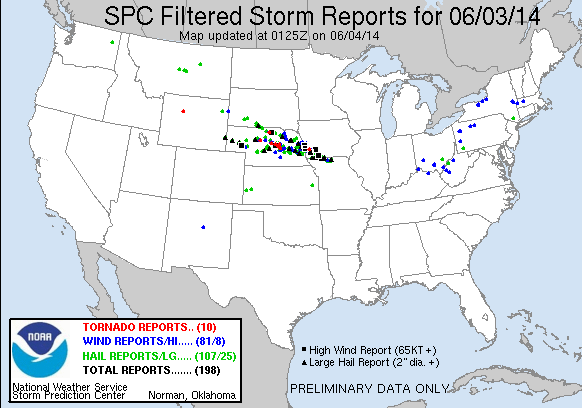
Daily Summary: Week 4, Day 2 (3 June 2014)

0603_reportsA strong short-wave trough moved through the Central Great Plains, generating severe thunderstorms in a strongly unstable and sheared environment.  During the event, we operated in two CWAs: Hastings and North Platte.  Forecasters Pelczynski and Anderson operated in Hastings; forecasters Fowle and Satterfield operated in North Platte.

When we started operations, convection had already begun in NC Nebraska, and it began to grow upscale as the sytem moved toward Omaha.  Further west, convective initiation held off for some time, before multiple storms fired along the warm front that stretched across central Nebraska.  A supercell near Ord, Nebraska became tornadic, and produced multiple tornadoes along its path just south of Omaha.

However, as the cold pool north of the warm front strengthened, it became increasingly clear that a major tornado event would not occur.  At the time of this writing, however, it appears that a significant wind event may still occur in eastern Nebraska into southern Iowa / northern Missouri (per the SPC high risk).

-G. Garfield
Week 4 Coordinator

Tags: None

no warn – prob severe

nowarnThe storm highlighted had a decreasing trend in the prob severe category. It’s trend went from 35% to 11% in less then 20 min while storms just a county to the north had prob severe numbers over 90%. Based on this, we kept the newly issued SVR a county to the north.

jca

Tags: None

ProbSevere – Ongoing Convection

Have used the ProbSevere simply to analyze trends in ongoing convection.  It is a good “sanity check” simply to make sure all of the ongoing storms are warned.  I know the primary purpose was to examine initial development – but the readout provides a quick look at the relevant parameters.

Fowle

Tags: None