Outlook – 14 June 2010

Today we start week 9 of the 2010 EWP.  Our visitors are Angela Lese (WFO Louisville, KY), Melissa Kreller (Southern Region HQ, Fort Worth, TX), Marcus Austin (WFO Tallahassee, FL), and Dave Sharp (Melbourne, FL).

A long stationary front is draped across the southern plains, with a late season strong 500 mb jet max overhead.  This will provide severe weather and flash flooding opportunities from a broad region from the south Texas plains through central Oklahoma.  SPC highlights the area with a Slight Risk, and best chances of supercells over the Texas portion of the risk area where the deep layer shear is more adequate.

Because central Oklahoma is under the convective gun today, we opted to operate within the Lightning Mapping Array (LMA) network there.  Unfortunately, the morning flash flood over OKC (10″+) have caused some outages in the LMA netork, and thus it is unavailable.

Therefore, we are going to complete training through 530pm, break for dinner, and then do a short IOP focused on the 5% SPC tornado risk in Texas.  Most likley, we will act as WFOs Lubbock, Midland, San Angelo, or Norman (the latter, for the NW TX counties).

Greg Stumpf (EWP Weekly Coordinator, 14-18 June 2010)

Tags: None

Forecaster Thoughts – Pat Spoden (2010 Week 8 – MRMS/GOES-R)

I was part of a group of 5 new forecasters who reported for duty at 1PM on Monday, June 7, 2010. It was week 8 of the EWP, with each week bringing in new forecasters. The first couple of hours were spent training on the new products we were being asked to evaluate. The objective was to determine which, if any, of the newer products would be useful in a short-fused warning situation. Our feedback would be given via surveys at the end of each day and during debriefs at the start of the following day. Real-time reports were supplied by students and the SHAVE (Severe Hazards Analysis & Verification Experiment), if applicable, during the week.

Each spring, NSSL and SPC jointly put together the Hazardous Weather Testbed (HWT) in Norman, Oklahoma. The two main program areas are the Experimental Forecast Program (EFP) and the Experimental Warning Program (EWP). The EFP focuses on the weather prediction models while the EWP tests concepts and technology and focuses on short-fused warnings.

Severe weather was expected Monday afternoon over the Central Plains. I have to admit, the first day, I was relying more on the products with which I was comfortable with rather than the new products. However, I did try to compare their output to the real-time reports we were given and my “crutch” products. Several of us did participate in a “canned” case using the total lightning products with storms over northern Oklahoma. The lightning data was helpful, yet confusing, because there were several lightning jumps as the updrafts increased. These storms were made up of multiple updrafts so it was difficult to determine which updraft was key in forecasting severe weather.

During the debrief on Tuesday, I was not overly confident that the “new” products were going to be of much help. But, I thought, it was early, and I needed to give them a chance. Plus, it was a slightly different environment than back at my office and that probably had an impact on my analysis so far.

Thankfully, more severe weather was expected that day. The software allow us to create a virtual forecast just about anywhere. We were not allowed to see what the actual forecast office was doing so that we would not be biased. The focus Tuesday afternoon and evening was over Kansas. I really worked to bring more of the new products into use and my comfort level was rising. We were able to make use of the convective initiation products as long as cirrus was not in the area. The convective initiation products did show convection quickly developing over Texas where the skies were generally clear.

It became clear to me that reflectivity on the -20 degree C surface was extremely helpful and I began to bring in more of the estimated hail size (MESH). These were the MRMS (Multiple Radar/Multiple Sensor) products. The MRMS products took advantage of all radars and were helpful as storms moved over the KICT WSR-88D’s “cone of silence” where one could see the storm increasing in intensity, but probably not to severe levels. Many of the products would allow a forecaster to pick out the strongest storms rather quickly. While there were many products available to us, not all of them appeared helpful.

On Wednesday, the debrief was more vocal as we began to find more and more useful products and examples were given of where certain products excelled and where they were not helpful. There were a few storms in the Alabama lightning network area, so that was the area of focus that day. We saw several instances where the total lightning was picking up on storms before the AWIPS lightning mapper program picked up on them. One could see the utility of this in the future, bringing with it a potential for lighting statements and potentially lightning based warnings. We continued to test all of the products available to us.

By Thursday, I was excited about the prospect of testing more of the new products. It seemed that everyone’s confidence was increasing dramatically using the newer products, especially the MRMS products. We were in luck as supercells were developing outside of Denver. We could see via the situational awareness display that VORTEX 2 was going to be on those storms. They provided us with real-time written reports and live video of the storms. I thought how nice this would be to have on a regular basis back in Paducah.

My partner and I were warning on the supercells. I relied heavily on the MESH and both the 0-2 km and 3-6 km 30 minute rotational track products. They clearly pointed out the areas of concern. I did look at the traditional products, but with the reverse weighting of what I used back on Monday. As the event moved on, one supercell became several. This is where the MRMS products shined. We created a split screen situation awareness display. The MESH and our warnings were contained on one side with the rotational tracks and our warnings on the other. From this, you could quickly look up and ensure that everything was covered. We were not too concerned with becoming overly focused on these storms with that configuration.

Friday was an early day, arriving at the weather building at 10AM. We reviewed the week’s events and discussed ways to improve them. Some ideas were as simple as changing color scales, while others were to allow more “on-the-fly” changes to look at reflectivity on different temperature surfaces and different dBZ cores. Before we left, Dan Neitfield, SOO WFO OAX, gave a presentation on how they handle tornado warnings in Omaha.

My experience at the EWP was fantastic and I hope to go back again. I have learned a tremendous amount about what may be available shortly to the field, and hopefully, helped the researchers look at different ideas and improve upon all of the work that has already been done. I could clearly see how several of these products would immediately help back at the office. While we are blessed with good radar coverage at Paducah,   these products would help us even further in critical situations. I could recall past situations where we would have benefited from having these products available. I knew I was going to miss having them once I got back to Paducah. Thankfully, they are available as test products on the WDSS-II website. http://wdssii.nssl.noaa.gov/ .

Pat Spoden (SOO, NWS Paducah, KY – 2010 Week 8 Evaluator)

Tags: None

Forecaster Thoughts – Frank Alsheimer (2010 Week 8 – MRMS/GOES-R)

I took part in the EWP for a week during June. I was able to experimentally use satellite and lightning products from the GOES-R Proving Ground applications as well as algorithms and products from the Multi-Radar/Multi-Sensor project. I will talk about the benefits and weaknesses of both.

GOES-R products — The products I got to experiment with were the convective initiation, overshooting tops, and the pseudo-lightning. I see both promise and limitations, but some of the limitations will be rectified once GOES-R becomes reality.

Convective Initiation — During the week of the experiment, I found myself only occasionally being able to use the product. The lack of ability to detect initiation through cirrus is a major drawback, significantly limiting the number of signals. However, some of that may have been due to issues with the satellite images themselves on which the algorithm is based. Especially noticeable was a one hour period around 00Z when we only got 3 images in an hour’s time. That really made it hard for the algorithm to do its job up to its potential, and therefore made it difficult to give it a true workout for when it would be operational with GOES-R. In theory, the product would have use in operations before a convective event begins.

Overshooting Tops — There were a few more opportunities during the week to see this algorithm in action.While it did a good job in determining many of the overshooting tops during the events I worked, I did not get a whole lot of additional lead time over just using traditional radar interrogation. This is another case, however, where more frequent (at least every 5 minute) images from the GOES-R satellite may show more benefit to the product.

Pseudo Lightning — I found this product to be complimentary to, and in a few cases superior to, the ground based lightning detection networks to which we currently have access. There was one specific real-time case I remember where the total lightning product actual gave lead time to a cell that had become electrically active over both traditional radar interrogation methods as well as the ground based lightning network. This is very important since many lightning fatalities are recorded with the first strike. It will also prove very beneficial as we get more into decision support services, especially to support the safety of responders to incidents who are exposed to lightning hazards.

Multi-Radar/Multi-Sensor — I found some of these products more beneficial than others. I will talk about each grouping of products individually.

Gridded Hail Detection Algorithm (HDA) products — The bias-corrected version of the MESH algorithm created a product that was far superior to the current MESH algorithm associated with individual radars during the week I participated in the test. Once I got used to the product, I used it as a primary tool in the warning decision process and would definitely use it regularly were it available in the AWIPS system at my office. The non-bias corrected product was not quite as reliable, but it was still nice to have a product that updated more frequently than any VCP we have available today, as well as helped to mitigate the “cone of silence” issue we have with individual radars. I used the 30 minute swaths occasional when following a supercell, but did not find a lot of real-time use for the 120 minute swath products.

Hail/Lightning/Convective diagnostic products — The most beneficial of these products was the reflectivity products at specific temperature altitudes, especially the -20degC. The two minute updates of these products helped to identify rapidly increasing convective cores. The 50 dBZ echo tops as well as the height of the 50 dBZ above specific temperature levels (i.e. 0degC and -20degC) was also beneficial, but 60 dBZ would likely have been a better product to access. I didn’t find much use  for the VIL, VIL Density, and LRA products, although I have to say I didn’t really use them a  whole lot once I found some of the other products I liked better.

Derived Shear Products —  I found some cases where the products were helpful and some others where it was not. It has a tendency to increase values as one gets closer to an RDA because of the weighting process, which is a bit of an issue at times (although it’s an issue on the individual radars as well). Similar to the HDA products, I thought the 30 minute tracks had some benefit for tracking purposes, but not so much the 120 minute.

Cloud-To-Ground Lightning Products — I found the density product useful as it gave a discreet value which could be compared both to the trend of the cell in question as well as other cells. It would occasionally be better than the individual strike product we currently get on AWIPS because it was easier to discern the lightning frequency near an individual cell.

Frank Alsheimer (Science and Operations Officer, NWS Charleston SC – Week 8 Evaluator)

Tags: None

Week 8 EWP Summary: 7-11 June 2010

SUMMARY:

Week #8 of EWP2010 wrapped up the first week of MRMS and GOES-R experimentation.  We spent a lot of time in the High Plains this week, however we were able to get one event over the Alabama Lightning Mapping Array.  During this week, NSSL and the GOES-R program hosted the following National Weather Service participants:  Frank Alsheimer (WFO Charleston, SC), Dan Darbe (WFO Atlanta/Peachtree City, GA), Daniel Nietfeld (WFO Omaha, NE), Pat Spoden (WFO Paducah, KY), and Andy Taylor (Norman, OK).

REAL-TIME EVENT OVERVIEW:

7 June: Evening “practice” IOP for southeast Wyoming and western Nebraska, including Scottsbluff tornado that V2 was on.

8 June: All day IOP over Kansas.

9 June: IOP for the Northern Alabama Lightning Mapping Array area today.

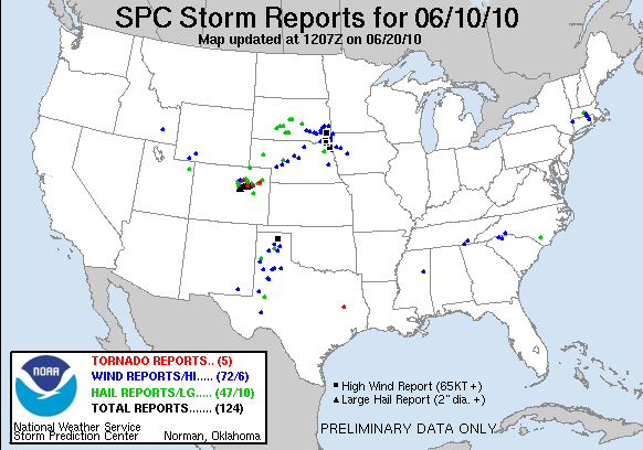
10 June: Front Range IOP today, including a tornadic supercell near Deer Trail Colorado that V2 was on.

MRMS:

One forecaster felt that the MRMS products helped add confidence to his decision making, but there was not enough time during the one week period to warm up to them.  However, another forecaster felt the rapid updates and multi-radar nature helped with quick identification of the severe storms, and then sparse grid products made the big cores really stand out from the rest.

As the week wore on, they became more comfortable with the MRMS products, and started to hone in on the specific products that worked best for their decision making.  They wanted to note that on the first few days, they weren’t as concerned about getting the warnings out sooner than the official warnings, knowing that there was no risk in a late warning.  [NOTE:  We’ll need to take that into account, hence why we’re doing some of the day-of-the-week composites in our analysis.]

They noted that there were big benefits that these were multiple-radar products.  They spent less time having to do an all-tilts analysis on all storms from each radar sensing the storm, or choosing the “correct” radar.

One forecaster commented that he was a firm believer in using MESH or another sparse grid designed for hail diagnosis to really narrow down the hail threat and make the polygons slimmer to avoid overwarning.

The rotation tracks really helped hone in on which storms to watch for tornado warnings.

Suggested improvements:  Add height information to the isothermal reflectivity products (could do multi-parameter sampling); an on-demand MRMS system where forecasters could create their own products (e.g., Reflectivity at -12 degC for winter precip) would be very beneficial.

GOES-R:

All agreed that cirrus presents major problems for the Convective Initiation (CI) product.  They also mentioned that the CI products do best in the first 10-15 minutes of an event.  Once warnings are starting to be issued, it was rarely looked at again.  CI would be useful on pre-dawn low-level jet warm advection situations to determine location of first convection, but that there needs to be some kind of alarm/trigger to notify the forecasters who might not be paying close attention.  A nighttime WES archive case was suggested for future experiments.  These forecasters also commented that there are too few CI detections, and wouldn’t mind lowering thresholds and adding uncertainty to get more detections.  There were concerns that CI, OT, and TC are too sparse sometimes to see, and better alerting/icons would help.  But some others abhor the bells and whistles of SCAN and GUARDIAN, and would want another way to alert.  Also, there might be need for separate day and night CI products.

Forecasters felt that the OT products were not needed when you can see them in the visible data, but it certainly adds more confidence about the storm being severe.

Regarding the PGLM products, suggestions included a cell table concept to plot trends, adding a lightning jump algorithm, a wintertime total lightning app, combining lightning data with other sensors, and rate of change products.  A discussion also ensued regarding short-term lightning threat products, or advisories for frequent cloud-to-ground lightning.

There are more details on the GOES-R HWT Blog Weekly Summary.

OVERALL COMMENTS:

Some comments echoed by former participants, including pre-made default AWIPS procedures (don’t like using others’ procedures), and fixing the MRMS loading issues with better hardware.  It was noted that the recommended hotel (Country Garden Inns & Suites) has taken a major turn for the worse this year and should no longer be used.  Not only did our software have bugs….

A LOOK AHEAD:

Next week will wrap up the 2010 spring experiment.  The pattern looks favorable for continued severe weather, mainly shifting into the Northern Plains by the end of the week.

Greg Stumpf, EWP2010 Operations Coordinator

Tags: None

Daily Summary – 10 June 2010

We are starting to wrap up operations.  Storms are either leaving the CYS domain or are diminishing in severity, so Dan N and Frank are starting their surveys.  The BOU crew is still operating a bit longer, but we’ll end their activities soon.

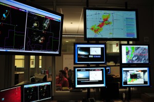
There was a tornado visible via streaming chaser cams on the SAD.  Also, we had on the large monitor in the corner a WDSSII display with two panels: one with warnings and MESH and the other with warnings and 30 min RotationTracks.  Pat really liked this as a SA tool.

We tried some GOES-R operations for a good part of the day.  The cap kept a lid on things in the GLD domain pretty much all day.  There were a few reports of overshooting tops to add to the CI detections.

Technical Issues of the Day:

  • Tupelo was slow to load when we switched Dan D to that machine.  He was trying to load his procedure.  We tried a reboot and it was still pretty slow so we just patiently waited for it to load.
  • Otherwise things worked quite smoothly.

Kevin Manross (EWP Weekly Coordinator, 7-11 June 2010)

Tags: None

Live Blog – 10 June 2010 (7:22pm)

Well, we’ve pulled the old switcheroo again.  We now have Frank and Dan N focusing on CYS and moved Dan D over to BOU where Pat and Andy are stationed.

Storms are actice with plenty of hail and what appeared to be a tornado via streaming webcam near the CO/WY border.

We will consider going a bit over the 02z ending time that we normally have since initiation was a bit late and the storms are interesting.  We will try to remember to give enough time to do surveys without holding everyone too terribly late.

Kevin Manross (EWP Weekly Coordinator, 7-11 June 2010)

Tags: None

Live Blog – 10 June 2010 (6:35pm)

We have switched Pat from CYS to FTG and added Andy to that team as well.  Frank is finishing out a warning with CYS and will jump on beard with Pat and Andy shortly.  Dan and Dan reamin waiting for storms to enter GLD, which should do so soon.

Kevin Manross (EWP Weekly Coordinator, 7-11 June 2010)

Tags: None

Live Blog – 10 June 2010 (6:20pm)

We started off with “Team Dan” in the BOU CWA, but switched them to the GLD CWA since it appeared more likely for CI with the satellite product.  “Team Frank & Pat” have remained in CYS and have issued a few warnings by now.

As I type, there is a tornado watch that covers FTG and GLD.

Kevin Manross (EWP Weekly Coordinator, 7-11 June 2010)

Tags: None

Outlook – 10 June 2010

Today we again started our debrief with looking at the previous day’s CI products.  In this case, we reviewed areas that were outside of where we operated since yesterday’s domain was dominated by thick cirrus/ice.

We then switched to a discussion of the pGLM products.  A comment was made that suggested that the pGLM added some advance dense CG areas and potentially helping to more early identify (or at least add confidence to) new and healthy updrafts.

We wrapped up the discussion with quickly reviewing some MRMS data.  We focused on the Rotationtracks product as a potential aid in areas where swatchs of strong winds may be occurring or have occurred.

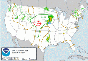
As for today’s activities, since there appears to be no chance for severe weather in any of the LMA domains, we will focus on the SPC MDT Risk in NE CO/SE WY/W NE.  The cirrus appears to be cooperating and today will hopefully be a good day to examine the GOES-R products.

We are anticipating a longer shift possible and we are starting with Andy working on the archive case while Dan D / Dan N are monitoring convective initiation in the BOU CWA.  Frank and Pat are doing likewise in the CYS CWA.  We have localized LBF and GLD CWAs in anticipation for later this evening if needed.

Kevin Manross (EWP Weekly Coordinator, 7-11 June 2010)

Tags: None