Live Blog – 7 May 2009 (5:42 pm)

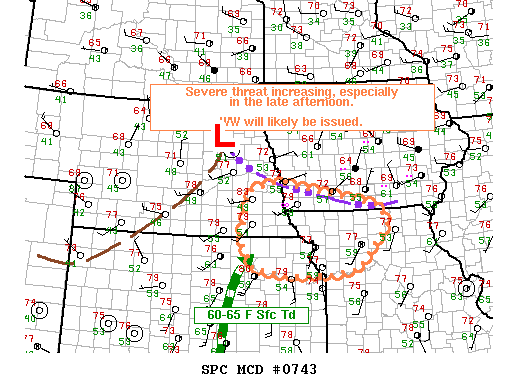
There was a choice between two areas IOP domain, based on the SPC Day 1 Convective Outlook:  Slight risk in NE KS, NW MO, and SE NE vs using the same Carolina domain from the previous two days.   The choice was to go with the Plains domain based on better shear and the fact that an MD and TOR watch were issued by the end of the briefing.

Initial plans were to start the IOP initially, followed by a PAR/CASA playback to start at 6:30.  Technical difficulties with AWIPS/LDAD prevented the IOP from starting on time.  In addition severe weather did not occur in the IOP domain while troubleshooting occured.  So, we decided to do the PAR/CASA playback first and then do the IOP later.

Because of the AWIPS issues, the IOP will be conducted in a group format with a live blog documenting the forecasters’ warning decisions.

Dale Morris (EWP Backup Weekly Coordinator, 4-8 May 2009)

Tags: None

Outlook – 7 May 2009

It looks like a return to North Carolina today.  Currently, SPC’s day 1 outlook is on the fringes of all of our LMA network domains and the timing is not there for a possible real-time PAR exercise as the models have convection late on the edge of the PAR domain.  However, per NSSL WRF and NWSFO RAH’s local WRF, it appears we will have another opportunity at storms in North Carolina today.  These models are suggesting storms will develop in central NC in the 18-20Z timeframe and then move east.  The models also suggest a complex of storms will form before moving off the coast.  This allows for the possibility of an extended MR/MS IOP with a good mix of storm mode, including supercells.

Kiel Ortega (EWP Weekly Coordinator, 4 – 8 May 2009)

Tags: None

Summary – 6 May 2009

End of IOP.  Storms in the RAH CWA are rapidly trending down and leaving the CWA.  Since we started before 4 this afternoon, we’ll call it a day.  Discussion follows…

Used the MESH and RotationTracks for intensity trends more than location.  Storms today didn’t really deviate much.  Tracks helped to narrow warning areas.  There was some question regarding the usability of the Lightning forecast products in their current form.  Color table may need to be adjusted.

Scott – liked trends a lot.  Found them to be quite useful and informative.

Gino :: trends seem “black boxish” right now, so confidence is low.  Relies more on based data.  Worried about false peeks and whether to trust the intensity diagnostic.  Good SA tool and for “post analysis”.   Likes Reflectivity at -20C

Suggestion :: VIL (or a Reflectivity sum product) above -20.

Slider capability for product values, similar to how we adjust isosurfaces.

Products in GoogleEarth were very popular.  Most agreed that they would be useful in SA.

Trends were helpful in discriminating between “similar” looking storms.  Trends were also useful in warning decision making.

Kevin Manross (EWP IT Coordinator)

Tags: None

Live Blog – 6 May 2009 (7:06 pm)

We are currently talking about the different ways to display and interpret the lightning probability product.  The forecasters seem to agree that a swath from 0-15 min, 0-30 min, etc. might be a better way to visualize the probabilities.  The problem of also going from a 100% probability to zero in a single pixel was also discussed.

Kiel Ortega (EWP Weekly Coordinator, 4-8 May 2009)

Tags: None

Live Blog – 6 May 2009 (5:33 pm)

Talking with Tom (WDSSIIB) for a moment.  Due to the technical difficulties that we’ve been having (and may be stabilized for the time being), Tom is just now starting to use the MRMS gridded info.  He has been looking at the RotationTracks, MESH, and Reflectivity at -20C.

Kevin Manross (EWP IT Coordinator)

Tags: None

Live Blog – 6 May 2009 (4:52 pm)

Both teams (WDSSIIA :: Gino/Jeff & WDSSIIB :: Tom/Scott) have been issuing warnings despite the MRMS grids not auto-updating in AWIPS.  They have relied on base data analysis, along with suplementing MRMS grids/trends via GoogleEarth.

We are still focusing on RAH, with storms entering an ubstable environment fromthe west of the CWA.  Greg is troubleshooting the notification of the MRMS grids in AWIPS.

Kevin Manross (EWP IT Coordinator)

Tags: None

Outlook – 6 May 2009

Again today convection was mistimed in travelling through an LMA area during the morning hours.  Currently, a broken cell squall line is moving through Alabama; this is on the eastern edge of a solid line which extends from just east of Dallas into Mississippi.  Currently a tornado watch is out for the broken line until 23Z.  High-res WRF runs break out convection in NC and VA during the evening hours, which should provide for an evening MR/MS IOP area.

Kiel Ortega

Forecasted 1km reflectivity from EMC WRF
Forecasted 1km reflectivity from EMC WRF valid 00Z 7 May 2009
Composite reflectivity at 1510 UTC
Composite reflectivity at 6 May 2009 1510 UTC

Kiel Ortega (EWP Weekly Coordinator, 4 – 8 May 2009)

Tags: None

Summary – 5 May 2009

FAIL.  A rolling snowball of computer problems led to no MR/MS IOP during the evening hours.  However, the day was not a complete loss as the forecasters looked at one more CASA and PAR case, received their introduction to the LMA and went through an introductory LMA playback case.  The forecasters were able to view the MR/MS products in wg and Google Earth, however, the AWIPS problems proved to be a major distraction.

Kiel Ortega (EWP Weekly Coordinator, 4-8 May 2009)

Tags: None