GOES 16 – Full Disclosure

Ok, last post….honesty time.

I didn’t make this a secret in my application that I had been out of meteorology for about 4 years between 2014-2018. During that time, GOES-16 launched. As I returned to broadcasting, I didn’t adequately spin-up on the new capabilities of this new generation of satellites. I was aware of the spatial and temporal resolution improvements of course – what meteorologist – currently working in or out of the field, didn’t get excited about 1 minute imagery?

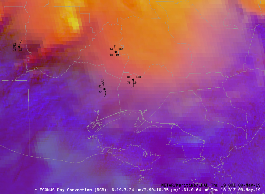
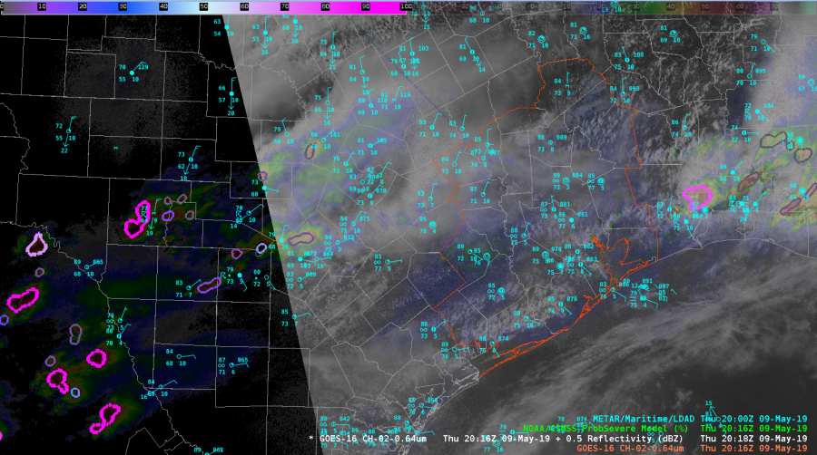
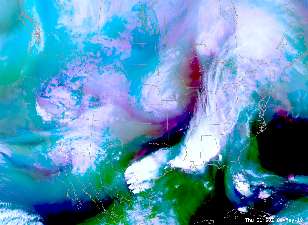
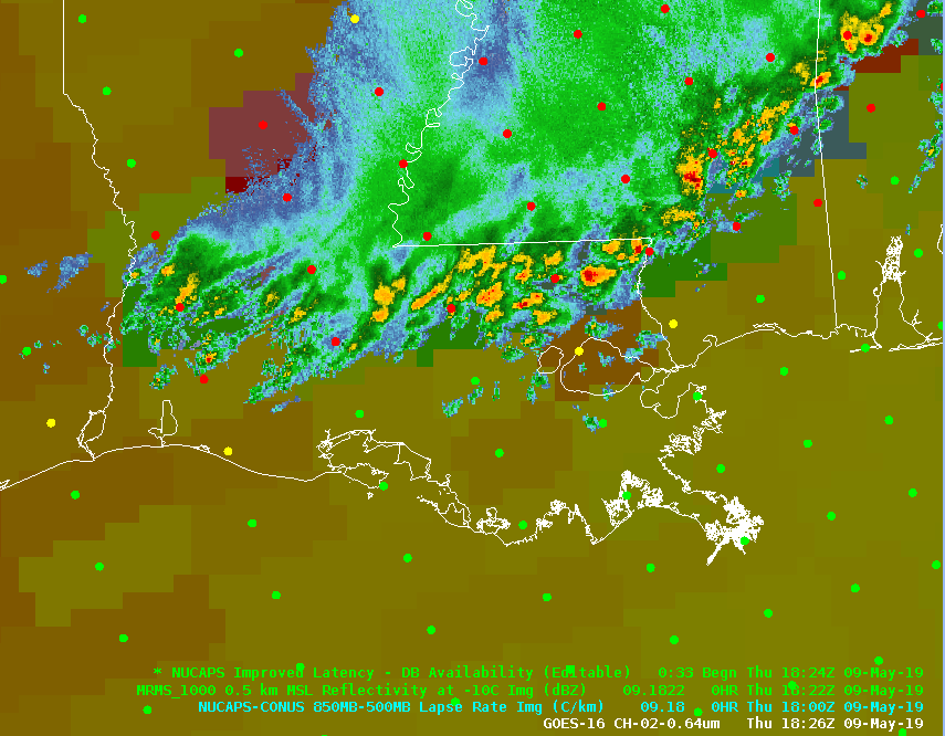
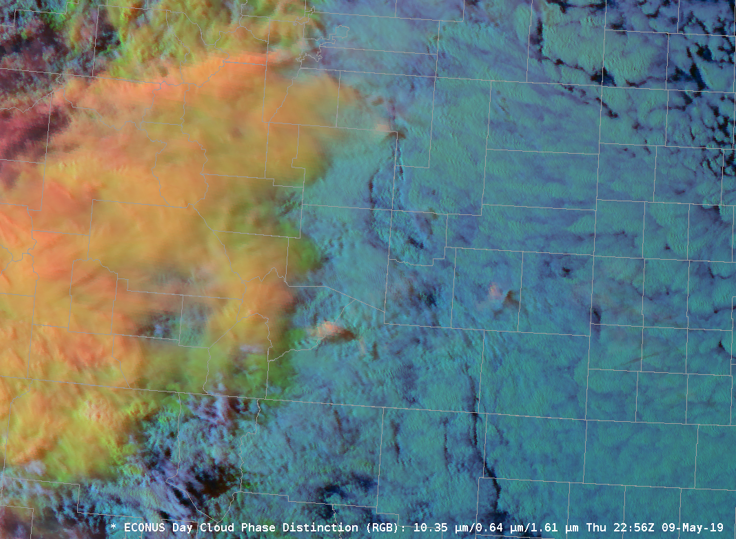
However, I wasn’t aware of some of the RGB combinations that I’ve been exposed to here at the HWT. The features that can be picked out by applying coordinating colortables to multiple channel views is simply astounding. I’ve used the simple water vapor, day cloud phase distinction, day convection, differential water vapor RGBs this week….I’ll be making a phone call to my broadcast weather vendor. I know I’ll need to get some other broadcasters on board with me to lead a charge, but count me in. Until then, I’ll be livin on the CIRA RMMB Slider site!

Color (RGB) Me A Fan!

-icafunnel

NUCAPS Comparison with Special 17Z Sounding

Today we were tasked with the LIX CWA (New Orleans/Slidell, LA), and the NUCAPS sounding went overhead at 1824Z. Luckily there was a special sounding out of the LCH (Lake Charles, LA) office at 1700Z so there was at least a loose chance to compare the data. So, let’s do just that! First the LCH sounding…

Shows a relatively unstable atmosphere with decent lapse rates in the mid-levels.  And now the nearest good-value NUCAPS sounding (taken just north of Vermilion Bay)…

The two soundings aren’t an exact comparison, they aren’t in the same location or taken at the same time, but synoptically it should be a pretty similar environment ahead of the broken line of storms moving into the area. The biggest problem comes in the boundary layer with values that are way off. The profiles were showing a 2m value of 76/70 when in the observed sounding it was 82/75. Given that the sounding was taken earlier in the day, it’s troublesome that the temps were much higher than the NUCAPS sounding. Unfortunately, modified soundings were not available on this day and given the unmodified soundings inability to correctly analyze the boundary layer, it makes trusting any surface derived data near-impossible. The only application I can see for these soundings are to analyze the upper-level synoptic environment (i.e., upper-level lapse rates, relative humidities, etc.) For this, you can compare some values… 850-500 Lapse Rate was 6.1 C/km in the NUCAPS sounding it was 6.7 C/km, some variability is expected and it’s not too bad but the difference is worthy of caution. In the gridded product somehow the Lapse Rate was 6.48 C/km, much better given the expected variability but I’m not sure these values are different. Are the gridded data not derived from the soundings or vice versa? Mid-level RH in our LCH sounding is 90%, yet in our NUCAPS sounding it’s 79%. I’d expect these values to be a bit closer given the strengths of NUCAPS, but it’s close enough to perhaps chalk up to differences in space and time.

Afterwards, I saw that LIX also had a Special Sounding that could be comparable, I’ll leave the comparisons below…

#ProtectAndDissipate


This was interesting

Since things were kinda boring over HGX today I had to look for things to blog about. Here is something interesting that I noticed with the Vis/IR Sandwich RGB. At the beginning of the loop the RGB didn’t show any IR brightness temperatures. As the TCU continued to develop we saw pixels of IR brightness temperatures starting to show up indicating cold cloud tops and the potential for glaciation to start. Low and behold, if we continue to watch the loop, more pixels start showing up…and a few minutes later both GLM and ground based networks picked up on a couple of CGs. As the thunderstorm developed, cloud tops cooled and more pixels started getting displayed we began to see more lightning.  This was something that I didn’t expect the RGB to pick up on and potentially helpful for situational awareness and IDSS in the west where most lightning tends to come from single cell thunderstorms. If you are able to pick up on these ahead of time you may be able to some lead time before lightning occurs.

Update…it happened again, pixels starting being displayed and then lightning occurred within a couple of minutes. If this generally hold true for single cell thunderstorms this would be awesome for outdoor IDSS.

Life and Death in One Loop

Well, the convection is trying. And dying.  Case in point, the full life cycle of a pair of storms across the  northern suburubs of Houston.  Thoughts below:

You are looking at the 1-minute Mesoscale Sector scan with GLM Flash Extent Density, the Vaisala GLD dataset, and ProbSevere overlays.  Some things to look at:

ProbSevere struggled when the storms were most intense by merging two individual storm objects, splitting them apart, then re-merging back into one object.  Trends were a mess because of this.

GLM lightning activity ceased a full 10 minutes before ProbSevere dissipated the tracking associated with the cells.  However, it continued to show flashes taking place for 7-minutes after the last CG was detected in the GLD data.  Good use for IDSS to let people know that cloud-to-ground strikes are still possible.

The storms initially were moving northwest along a boundary then deviated to the northeast as they strengthened.  As soon as the moved off the boundary…bye bye!

-Dusty

NUCAPS FCAST

Knowing that the NUCAPS FCAST information was in today for the first time this week, I decided to do some analysis of the fields. Initial thoughts are that the missing blocks of data (not sure if that is typical – more visible in the CAPE field in top image – similar data holes observed in LCL, LFC and EL) make it hard to have confidence in it at first glance.

CAPE (Top Image)
NUCAPS FCAST CAPE data isn’t good in the pre-storm environment along the LA coast. RAP13 initialization is overlayed for comparison. RAP13 values are 2500-3500+ and much more representating thatn the NUCAPS values that in some cases are less than  500 ahead of the line.

CINH (Lower Image)
While these values appear to be more closely representative compared to the RAP13, the inability of the product to adequately represent the boundary layer at times during the week don’t provide me much confidence for these surface based stability parameters.

-icafunnel

Shields Disengaged

The cap finally broke over Houston’s CWA and we now have some storms to look at. Hopefully, these storms will hold together and become better organized so we can look at other products today. Given that CAPE is generally around 3000-4000 J/kg it shouldn’t be a problem, but we are on borrowed time.

Tags: None

NUCAPS_Ahead of Line

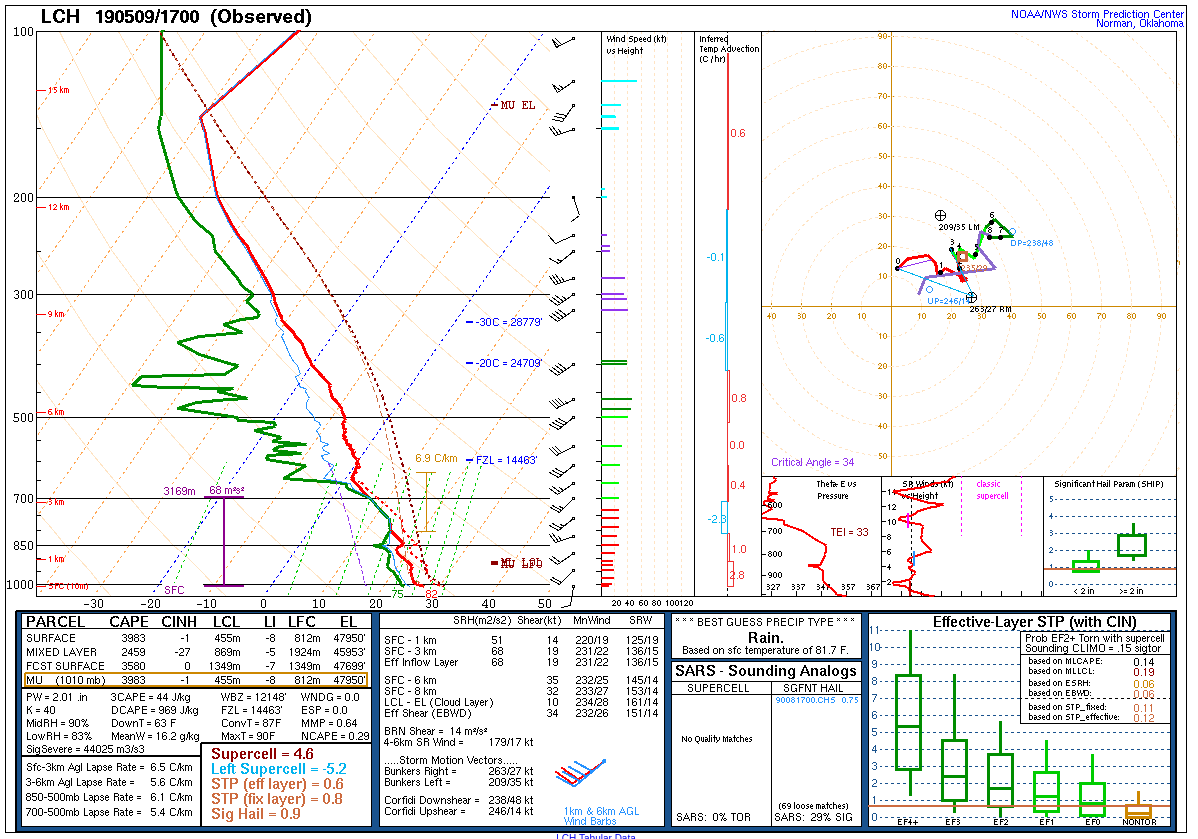
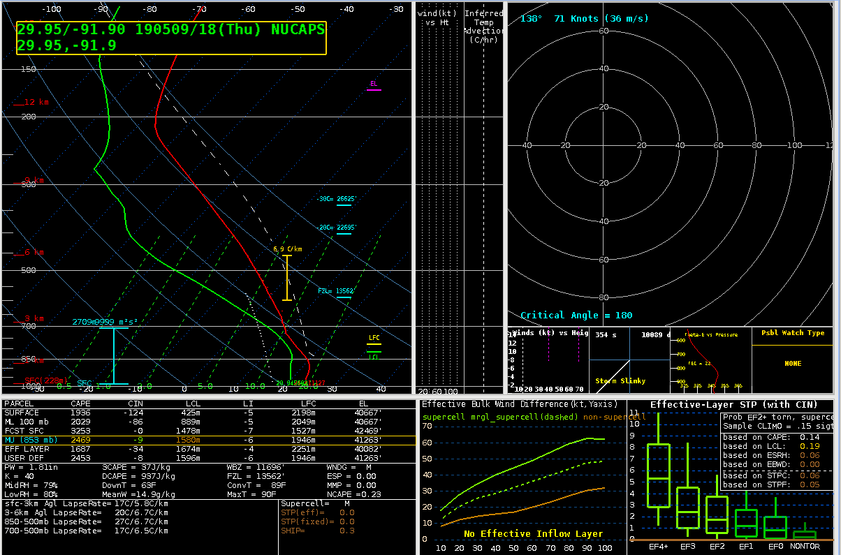
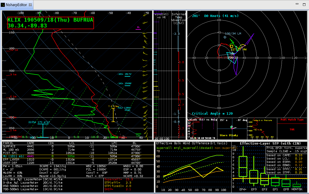
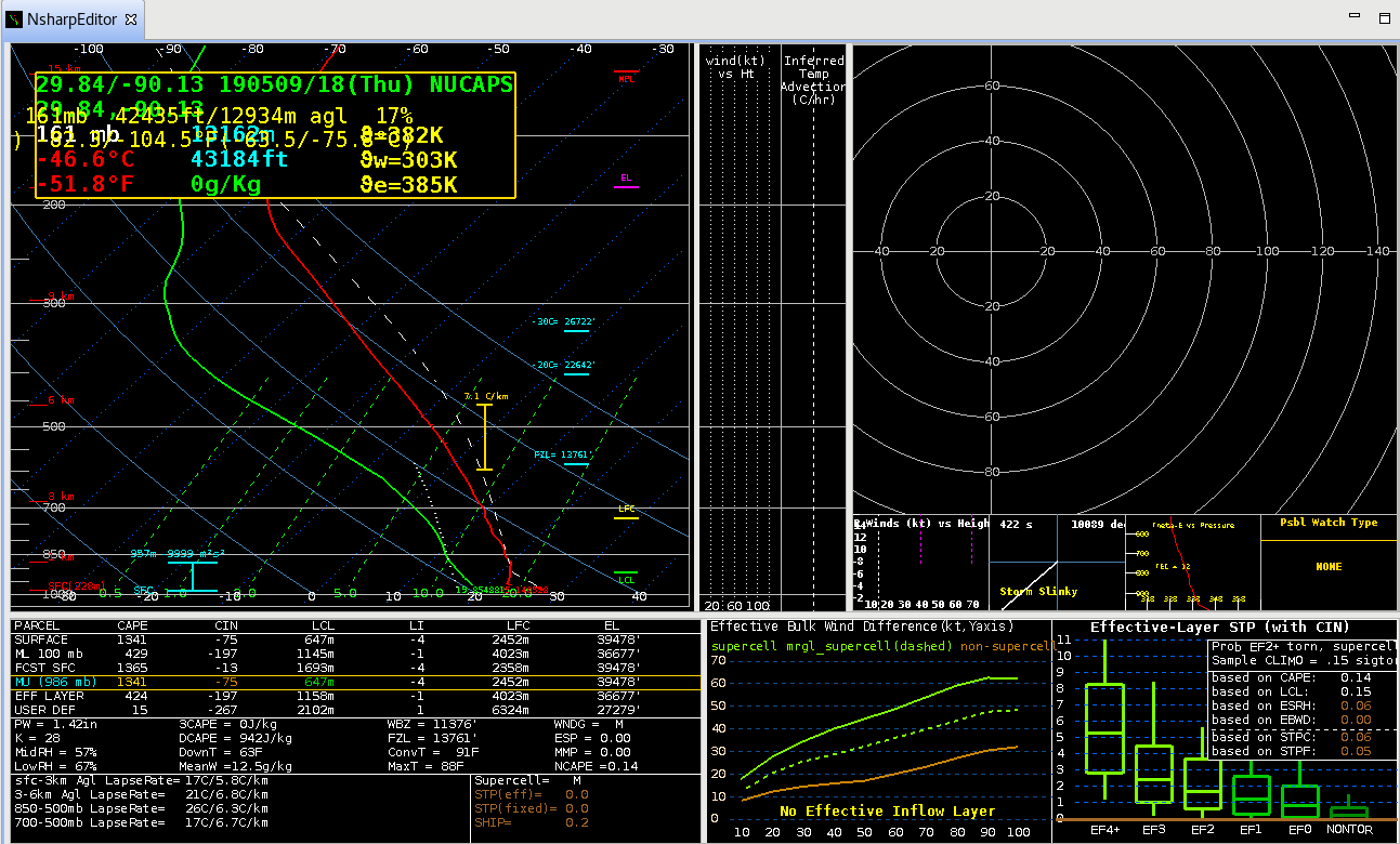
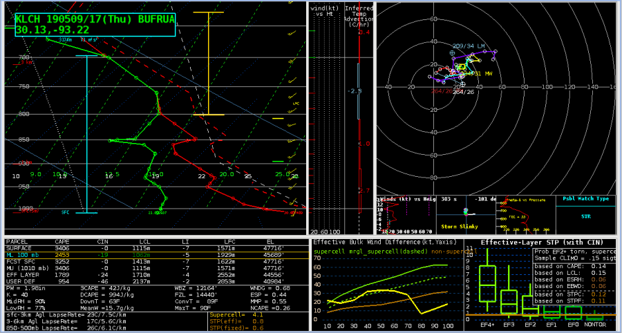
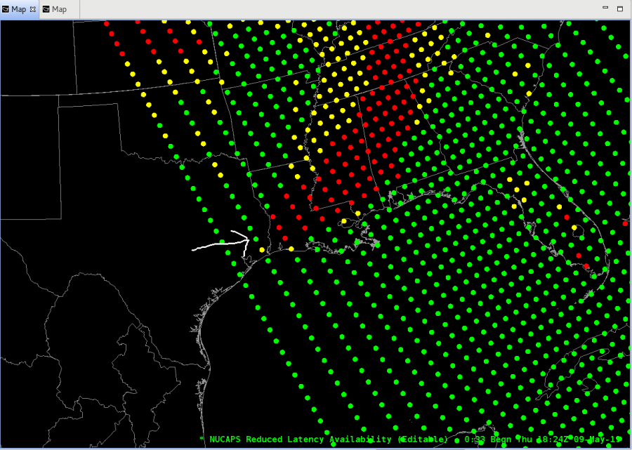
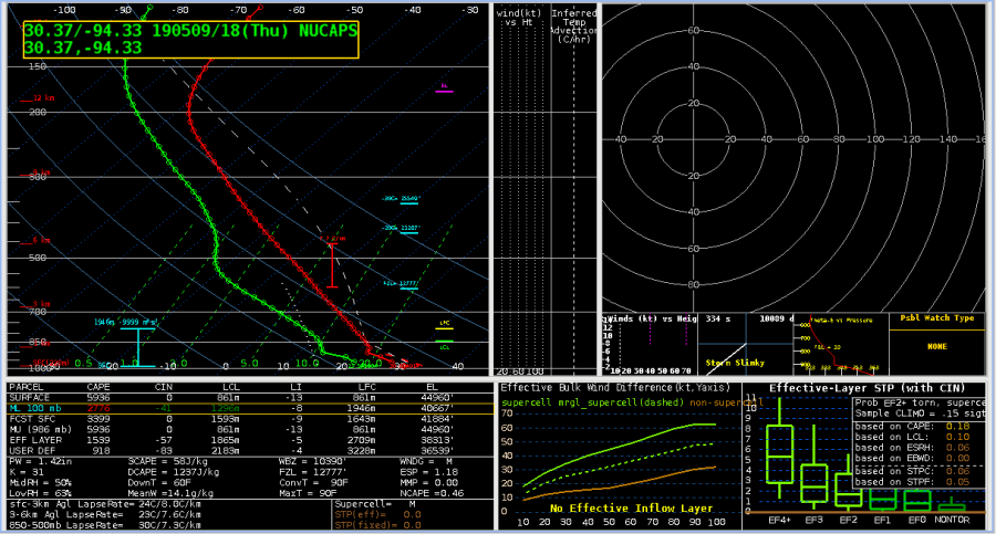
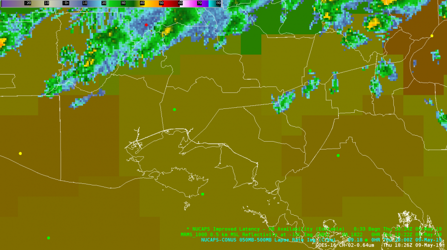
NUCAPS data in advance of convective line today. Iberia County METAR station coincides with NUCAPS operational sounding (modified soundings not available today).


As you can see from the plotted NUCAPS sounding below, the surface values are too low. From the METAR in western Iberia County, you can see in the first image the the T/Td values are 81/76. Sounding surface values are 76/70. Other sounding points in the pre-storm environment are also about 5 degrees too low on temp and dew. While I can modify these, it doesn’t give me confidence in an accurate representation of the boundary layer and on any day expected to be busy I’d likely use other products.

-icafunnel


Wherefore art thou Convection?

Two hours in and we are STILLLLLL waiting for convection to fire in the KHGX CWA.  Front is stalled across the northern quarter of the CWA and the sea breeze has pushed inland from the southeast.  Come on storms…really?

O.K., why no convection?  KLCH launched a sounding at 17Z which looked like this from GOES-E (why this is important in a bit):

Congrats to Lake Charles getting a special sounding off before those storms arrived!  This is what the lowest half of the sounding looked like with boundary layer conditions guessed from the near the center of Houston’s CWA at KTME (Houston Executive Airport):

No Cap, ~2500 J/KG MLCAPE, surface moisture isn’t mixing out too much….so, where are the storms?

Let’s take a look at a NUCAPS sounding taken from this point almost an hour after the KLCH sounding:

I know you are going to ask…why not the next closest dot further west?  Well, it is on the edge of the instrument swath and that has a whole host of problems.  Second thing is that the soundings along the edge looked…wonky…compared to the next row further east.  The sounding at that point, again modifying the surface conditions for KTME (88/75 T/Td):

Things that make you go; hmmmm.  Using the MLCAPE profile, the NUCAPS sounding shows that there probably is a residual EML behind the departing storms that the KLCH didn’t capture ahead of the storms.  That may be just enough to keep the atmosphere capped and storms at bay.  There isn’t much of a cap, so hope continues we will get convection over the KHGX CWA.

NUCAPS sounding profiles – thumbs up for helping figure out what is going on.  And get more polar orbiters up and going so we can have more than two soundings per day…preferably on different orbital inclinations for better spatial coverage. Please?

-Dusty

MRMS and ProbSevere – SAD Match made in the EWP

Wanting a good way to keep up on the environment while also monitoring for storm development?  Give this combo a tryout (and note, I totally stole this from another EWP participant this week.  Why?  Because it works!)

Top left: MRMS Reflectivity at Lowest Altitude (RALA), Reflectivity at -20C, ProbSevere All
Top right: MRMS Maximum EstimatedSize of Hail (MESH), MRMS 60 Minute Hail Tracks (50%             Alpha), ProbHail
Bottom left: MRMS Vertically Integrated Liquid (VIL), MRMS Vertically Integrated Ice (VII,                    100%), ProbWind
Bottom Right: MRMS 0-2km Merged Azimuth Shear, MRMS 0-2km Rotation Tracks 60-minute          accumulation (35% Alpha), ProbTor

The nice thing with this display is that you can quickly sample any of the objects to get details on what is going on with any given storm to keep situational awareness.

Yeah, that’s a lot of text on the 4-panel but each one is specific to the threat in the pane and the ProbSevere (top left) is a bit of everything mixed in.  So far, it has worked with all convective modes we’ve seen so far in the Testbed.

-Dusty