Moderate CTC 25 minute LT to 0.7″ MESH

At 2045z the Cloud-top-Cooling product signaled a 12 C/15min value. This is on the moderate scale and validation study states that this value should lead to a 33 minute lead time to non-severe hail.

CTC
Upper right panel is CTC

At 2112z the MESH product signaled a 0.71″ Maximum hail size which is close to what the product is suppose to signal for the forecaster.

CTC2
Upper right panel is MESH

Hampshire


Tags: None

Cells in Western Kansas are Moisture Starved

The cells which have been trying to initiate since 2 PM have struggled with only weak reflectivity returns noted. There is instability available for convective updrafts and this is noted on the GOES Theta-E Difference on the bottom right panel of the image below. The blue colors signify an unstable airmass. Some other inhibiting factor is preventing these updrafts from further organization. This is most likely due to poor moisture at the present time. The GOES Vertical PW product shows little change of moisture between the low-levels and the mid-levels of the atmosphere in Western Kansas. This is evident by the light pink/purple colors in the product in the upper right panel. As these cells move east over the next 2-3 hours, they will encounter low-level air that has a bit more moisture available as evident by the darker pink/purple colors in the product. This could have an impact on the cells and we could see the storms become better sustained.

moisture

Hampshire

Tags: None

Using Goes-R CI to Evaluate Developing Cumulus / weak cells

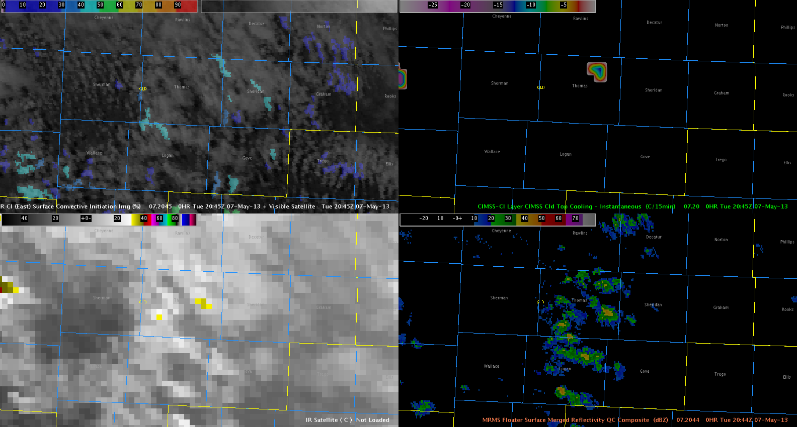
A line of cumulus clouds developed across western Kansas near/after 18Z. EFP/SPC forecasts indicate this as a favorable area for storm development in the next few hours. For now, the GOES-R CI product is indicating generally low probabilities of convective initiation along this line of towering cumulus (20-60 percent).

goes_r_ci-05071902

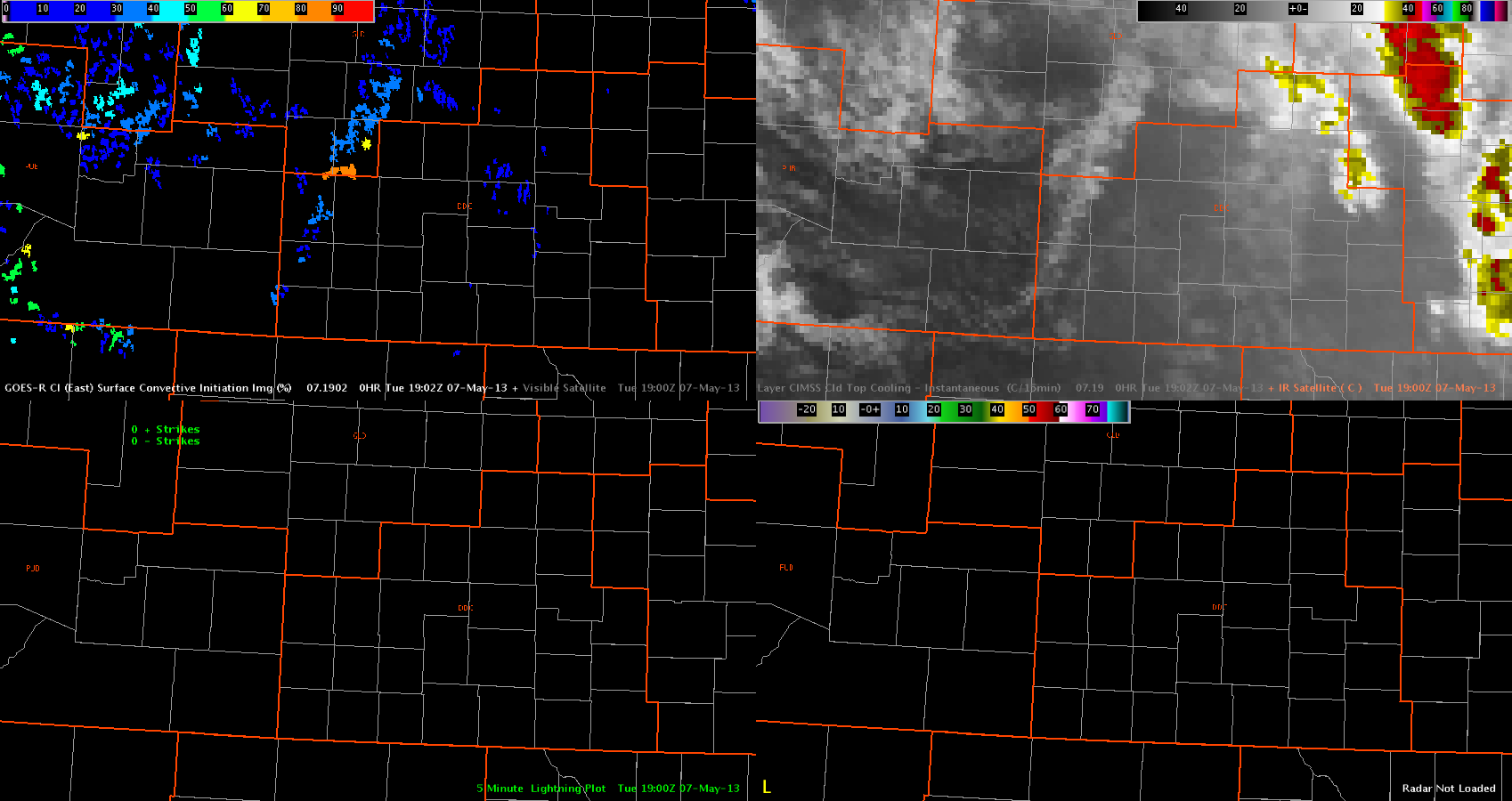
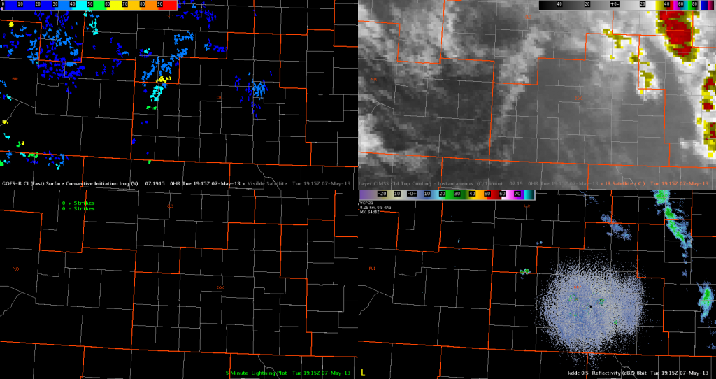
One area with a probability of 80 percent developed, at around the same time that a small/weak cell (Z < 35 dbZ) developed in Wichita County. This indicator decreased below 70 percent in the next few products, as the cell generally failed to develop into anything stronger.

goes_r_ci-05071915

So far, the CI product appears to be correctly indicating that large-scale convective development is not imminent quite yet. Also, the CTC product has not shown any indication of rapid cooling, which also matches the current situation.

–Hatzos

Tags: None

Approximate 15 Minute Lead Time for Severe Thunderstorm Using MRMS and HSDA

An isolated storm continued to move north/northwest across northern NC. The storm began to intensify as it moved into Stokes and Rockingham Counties. Continued to monitor various MRMS products including MESH and surface height of 50 dBz echo above -20 C, as well as surface reflectivity at -10 C and 0 C. Early MESH values were below .25 inches, with the highest 50 dBz echo approximately 6000 ft below -20C. Recognizing from previous storms this evening, with such a cool air mass, and decent low level lapse rates, severe hail was possible with 50 dBz cores below -20 C. Issuing a warning as the core increased, we continued to monitor the MRMS data, noticing the MESH had increased to approximately .50 in with 50 to 57 dBz at -10 C. We also used FSI to investigate the addition to the HCA algorithm, the new HSDA (Hail Size Determination Algorithm). As the storm moved northwestward, it started to indicated large hail (1 to 2 in) and then increased to greater than 2 inch hail southwest of Meadows, NC, which is where the report of quarter size hail was reported near 0044Z. It was also near this time that the 50 dBz core was finally reaching the -20 C level. Although we only received a report of quarter size hail (1 in), the additional products improved our confidence in the severe nature of the storm.

FSI screen capture of HCA with new HSDA. The purple color is Large Hail (1-2in) and the magenta is Giant Hail (>2in).
FSI screen capture of HCA with new HSDA. The dark purple color is Large Hail (1-2in) and the pink is Giant Hail (>2in).

Kurtz/Frank

Tags: None

Analyzed Severe Storm in Northern North Carolina Using MRMS

Issued a severe thunderstorm warning for quarter sized hail for a storm that was moving out of Yadkin County NC and moving into Surry and Wilkes Counties. Started by analyzing storms with the suite of MRMS Data. We initially looked at the MESH product, which was indicating .25 in hail. Knowing that the storms had a history of producing quarters, we interrogated with the MRMS Height 50 dBZ echo Above -20 C. Noticing a lack of 50 dBz echos over -20C, we concluded that given the depth of the cold air under the cutoff low, severe hail was possible with lower cores than normally anticipated.

MESH overlapped on 0.5 deg Z

FRANK/KURTZ

Tags: None

Using Hybrid Hydrometeor Classification to Warn on Large Hail

Forecasters monitored several multicell storms over the southern Blacksburg CWA. Conditions were not optimal, but a few reports of quarter to golf ball sized hail were received in the county adjacent to the extreme southwest portions of the CWA. The attached image shows a four panel of base reflectivity, MESH trails, and HHC, which indicated large and giant hail in several pixels.
4-panel of reflecivity, MESH, and HHC

Austin/Hatzos

Tags: None

OAX: Nice depiction of wind event over southern Omaha

KOAX 88D and 3DVAR analysis clearly showed a damaging wind event across southern Omaha and Offutt AFB.  The images can speak for themselves. Only if the warning forecaster was paying close attention to the base data from KOAX, would he/she have caught the event much ahead of 3DVAR. Note also the Tim and I had warning out of this area well in advance of the event as the hail threat quickly evolved to a heavy rain and damaging wind threat.

SNELSON/TMT

Tags: None

ABQ: CTC + Situational Awareness = Great Fcst

Although we are in AMA, we took a look at the CTC in NM, since that area has seen significant CTC signals over the last week. Once again, we are seeing strong CTC signals off the terrain in NM with little or no convective development. Here are a series of 3 signals in the same place over several hours. Take home point — this is a great product, however forecasters need to know their environment to use this product in enhanced warning ops and beware of times that the convection is being forced by the terrain. Case in point, although the CTC product showed -20->-25c/15min cooling values over higher terrain areas in SE NM, the sfc dwpts were in the teens and lower 20s. Almost no way convection could develop with this dry air. MRD

2015z:

2215z:

2315z:

Tags: None

AMA: Gonna Eat at the Big Texan Tonight

We have switched CWA’s and now are located in the AMA CWA. Ongoing supercell thunderstorms were severe when we began. Left moving supercell had a max updraft strength of 27 m/s. MESH was appropriately lagging and was giving me 1.5″ hail. Went ahead and added golf ball size hail to the warning, although MESH has now exceeded 2″ in diameter. With only a volume scan or two from the KAMA radar, the warning was based heavily on the MESH 30 minute track.

Tags: None

AMA — Severe in Potter Co.

MPX decided to move to AMA for the last hour of the experiment. MPX storms mainly just big rain producers with FF a problem. Went with a warning for Potter without much radar data yet mainly due to strong updraft, strong upper diverergence and MESH of 1.75 inch. Nice inflow into the storm as well.

Tags: None