CI East vs West Differences

In the Boulder CWA we are seeing the CI East product showing 64% for CI (fig 1) while the West version shows nothing (fig2). Seems to have actually produced a radar echo as seen in figure 3. Many low probabilities (>30%) have plagued the CI with nothing developing as of yet.  –Cattywampus

eastCI

fig 1: CI East

westCI

fig 2: CI West

z

fig 3: Reflectivity

Tags: None

Overshooting Top and ENI Time Series Comparison

We noticed a significant ‘lightning jump’ around 1820Z in the ENI time series which was indicative of the updraft increasing in strength and size. Not long after that at 1830Z, the overshooting top detection picked up on an overshooting stop associated with the same storm. It makes sense that we would see the lightning jump first, then get the overshooting top detection a bit later as the momentum of the growing updraft catapulted it over the tropopause.

ENIJump

OST1830-Helen Hunt

Tags: None

June 3 — JAX synoptic overview

Cutoff H5 low pressure passing across the TN valley and southern Appalachians today/tonight. H5 cold pool working SE across the northern portion of the JAX CWA (SE Georgia) with temps down to -11C through this afternoon into the evening, as noted off the 12Z GFS model.  Inverted trough along the SE U.S. coast with good low level SE wind flow allowing increasing LL moisture to work inland.  Already noting convection has already begun across SE GA and along the GA/FL border at 18Z, where one would expect to see this considering surface and upper level pattern.

17Z HRRR model also showing discrete cells and clusters developing across SE and S central GA into NE FL during the afternoon.

Both models showing cold front moving SE into northern SC and GA this evening/tonight, while moisture continues to feed NW.  Will see good low level moisture convergence mainly from about Atkinson county eastward to Glynn county.  Could see very heavy downpours with some thunderstorms, along with the possibility of strong winds and hail.

CoonieCatEye

Tags: None

Jacksonville Mesoscale Discussion

The CIMSS products coming in are a little old (16Z), but looking at the CAPE, LI, PWAT and SI, it’s pretty evident that the most favorable area for convection in the Jacksonville FA is the northern part. The CIMSS CAPE in this area is around 2000 J/kg, the PWAT is higher here than anywhere else in the FA (1.75”), and LIs are up to -6. I compared the SPC mesoscale analysis CAPE and PWAT (18Z) to the CIMSS data (16Z) and both showed the most favorable values in the northern part of the FA. The 0-6 km bulk wind shear appears relatively weak, so believe convection will be disorganized. The GFS model data shows a mid-level cold pool focused over the northern part of the FA, so this will likely be a focus for convective development. Believe that locally damaging winds and hail will be the main threats today. NAM forecast soundings show some dry air aloft which may enhance the potential for strong wind.

CIMSS3

-Helen Hunt

Tags: None

Meso Discussion of CYS

Moisture gradient exists across the CWA.  The image below shoes the GOES derived PW across the area.  The green area is 0.70 inches or higher.  These PWs are in the 90th percentile for DVR.  Moisture across the area is much higher than typical.Screenshot-CAVE:CYS - D2DPW

Satellite derived CAPE, shows a gradient across central portions of the CWA.  This CAPE looks to be relatively accurate with the overall gradient.

Screenshot-CAVE:CYS - D2D -1

Looking at the RAP, 0-6km shear is around 50kts, this is conducive to supercell development across the area.  An upstream wave is moving into the area, this wave is still across Utah and probably will not make it to the area to force the storms to go linear.   Main threat will be large hail and damaging winds. Low level shear should increase later in the period when the LLJ kicks in.  So our threats for tornadoes will increase around 00z.

MacGyver and John Pendergrast

Tags: None

Thunderstorm weakening as it moves toward Campbell Cty (ABR)

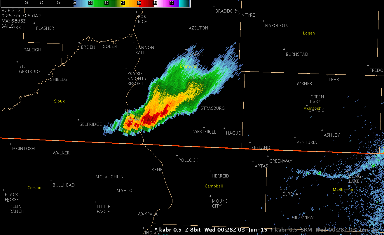
While monitoring a strong thunderstorm moving SE out of Sioux county near Fort Yates earlier this evening, we noted that the cell was beginning to take on bow echo characteristics (0050 UTC).  However, only two volume scans later, the cell began to reform out ahead of its parent cell (0054 UTC).  This broke down the bow echo, and by 0104 UTC, the cell was weakening as it approached the Campbell county line north of Pollock (Figure 1).

Here is the loop of the 0.5 degree KABR radar:

RadarLoop_KABR_3Jun15_0104Z

Fig. 1: Animation of KABR 0.5 degree reflectivity (click to animate)

Another excellent advantage of seeing the 1-minute GOES-14 satellite data is seeing interesting features.  We also noted that, at about the same time that the cell was redeveloping ahead of the parent cell, the clouds also redeveloped out ahead of the original line (Figure 2).

GOES14_1-min_Satellite_loop_3Jun15

Figure 2: Animation of GOES-14 visible satellite (click to animate)

CoonieCatEye

Tags: None

ENI Data with Storm Split

This was an interesting case where the storm split and the ENI data highlighted the stronger southern cell which was very beneficial in the warning process.

The ENI products all worked beautifully in this case. Initially, I noticed a slowly increasing trend in Prob Severe around 2346Z over the cell. By 2355Z, I noticed that there was an ENI DTA Thunderstorm Alert on the storm. At 0000Z, the ENI DTA Thunderstorm Alert increased to Significant and the Prob Severe split into two ovals since the storms had split by this point. By 0007Z, I  began to see that the southern storm had become the stronger of the two cells as the severe prob had increased to 72% while the northern storm prob severe was only at 42%. At 009Z, prob severe on the southern cell increased to 90% while it was still only 42% on the northern cell. At this point, I decided to go ahead and pull the trigger on the severe thunderstorm warning for the southern cell. Knowing that the prob severe was much lower on the northern cell increased my confidence that I should only include the southern cell in my warning polygon. The warning took a long time to get out due to some technical difficulties, so I didn’t get the lead time that I would have liked, but the warnings did verify. There was a report of 1.25” hail at 7:25 PM, 2” hail at 7:23 PM and 1” hail at 7:52 PM.

ENISplit(Click image to animate)

The ENI time series data was also helpful in this case as it showed lightning jumps around the same time I was seeing other signs of intensification. This increased my confidence that the storms were indeed intensifying and that a severe thunderstorm warning was needed.

ENIstormsplit

-Helen Hunt

Tags: None

Using ProbSevere as a key piece of info for warning decision.

Issued a SVR at 23:53z over northern Stutsman County. Lightning flash rate increased prior to intensification from 2340Z to 2347Z (fig 1) then the cell produced 55 dbZ to >30kft.  The cell was getting to be far from the radar with the 0.5 scan reaching only 12.5kft. ProbSevere showed probability of 94% at this time (Fig 2).  The limited low level information with a farther distance from the radar made the use of ProbSevere more heavily weighted in the warning decision. –CattyWampus

flashplot

Fig 1: Increasing flash rate from 2340Z to 2347Z.

2352zProb

Fig 2: ProbSevere 94% at 2352z.


Tags: None