Damage Surveys for May 7 event

A quick look at the PAR data indicates two separate short-lived circulations that passed through Oklahoma County and were scanned by the PAR.

Survey photos KML from Piedmont to Meridian and NW Expressway are attached. There was an almost continuous narrow path between the two locations, though part of it would have been over Lake Overholser.

  • Width = 50 yards usually, 120 yards at it’s widest damage point (baseball fields — I walked it off and also measured in Google Earth)
  • Length = 7.5 miles
  • TS DOD 3 — lots of big trees uprooted in the Ann Arbor and 50th street area –> EF1 (though barely).
  • SRB DOD 2 or 4 — concession stand at PCO fields was built like this (concrete blocks, metal roof) and lost about 25% of the roof. –> EF0 or low-end EF1

Too bad there is no EF-scale DOD for movable metal bleachers. I saw loads of those tossed around. One of them badly bent a steel-braced awning at the baseball fields.

A photo from newsok.com was in the back yard of someone’s house in Yukon, so I didn’t get in to see the damage myself. The only other stuff I saw in that area were some stockade fences blown down and some limbs removed (no uprooted trees or anything). So that part of the path could be EF1 based on the picture, but EF0 based on everything else.

Kiel and Angelyn surveyed the Edmond / NOKC circulation. Kiel writes:

I’ll use tornado lightly here…radar really helped pick this guy out. Anyways, attached is Angelyn’s and my survey. Gonna go EF0 on this bad boy…sporadic damage that eventually lined up into a path (2.8 miles long by 20 yards wide).

DI/DODs:
Trees (hard/softwood): DOD 3
Single family home: DOD 2
Aparment building: DOD 2

Given the last DI/DOD, winds up to 82 MPH.

(Travis Smith)

Tags: None

Pictures from Week 1

A few pictures from around the Hazardous Weather Testbed during week 1 of the 2008 experiment:

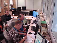
Mike Cammarata and Dr. Pam Heinselman discuss Phased Array Radar data.

Patrick Marsh and Kristin Kuhlman create probabilistic warning grids.

David Blanchard, Paul Schlatter, and CASA scientists explore a CASA case study.

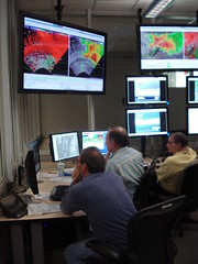
Mike Cammarata and David Blanchard monitor a tornadic supercell in real-time on May 1st using Phased Array radar as Les Lemon looks on.

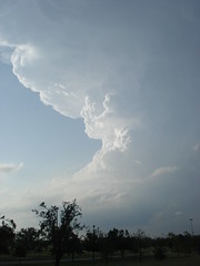
The developing stages of the May 1st tornadic supercell as viewed from the National Weather Center, looking northwest.

Posted by Kevin Scharfenberg, NWS Severe Storms Services Coordinator

Tags: None

And Away We Go?

This is the eve of our first operational “shakedown” day for the EWP 2008 Spring Experiment. Are we ready? Heck no! But we’re pretty close. This is the reason for the shakedown week – to iron out any remaining kinks in the system. It also our buffer week to get some of our remaining tasks completed, like the individual experiment plans, and our ideas on how we are going to conduct our daily map discussions and post-event debriefings. The equipment in the HWT operations area is just about ready to go, and most of the mess is finally cleaned up. This is the very first year we are attempting something on this scale, so we feel it will be a work-in-progress, with hopefully much of the work completed by the end of this week.

So, what does the weather look like for the week? A nice progressive trough will move across the nation’s mid-section. Gulf moisture is also starting to make an impressive return Sunday night, and should be nicely in place for several events this week. Monday may see the potential for storms in OK/KS/MO, with a potential sleeper event for Central or North-Central Oklahoma. Could it be a PAR/CASA day, or a gridded probabilistic warning day? We’ll know for sure after our first daily meeting/map discussion tomorrow.

Greg Stumpf (EWP Operations Coordinator)

Tags: None

This Site is Under Construction…

During the final weeks before operations, we are working hard to get all the hardware, software, and manuals ready for the spring experiment.

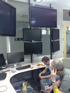
Here are Paul Griffin and Brian Schmidt finishing the installation of the Situation Awareness Display (SAD) The SAD will consist of 7 large LCD monitors that will provide images from any of the other EWP computer monitors, as well as live television, web page content, etc. These LCD monitors will be mounted above the desks in two areas of the HWT. This picture shows the main part of the SAD, our 5 monitor tower, located on the west side of the HWT operations area.

Greg Stumpf (EWP Operations Coordinator)

Tags: None

Shakedown!

We begin our first of two shakedown weeks at the EWP on Monday April 14.

The first shakedown week (14-18 April) will be conducted “loosely”, with no set schedule, as we make sure all the technologies and systems are in proper working condition. We’ll also use some of the time to train our weekly coordinators on the various systems.

The second shakedown week (21-25 April) will be conducted in the same manner and using the same schedule as an actual operations week, except with NSSL participants and some of the weekly coordinators only. During the second shakedown week, we will start to post our daily post-mortem blog entries. Watch for them beginning 21 April 2008!

Greg Stumpf (EWP Operations Coordinator)

Tags: None

Welcome to the EWP Blog

Here is where we will update participants and other interested parties on news and events regarding the 2008 Experimental Warning Program (EWP) spring experiment being hosted at the NOAA Hazardous Weather Testbed. The experiment will run for six weeks from 28 Apr 2008 through 6 June 2008. Operations will occur every Monday through Thursday of each of the six weeks. Weekly coordinators will provide a daily summary on this blog with some pictures and images of important events worked. An end-of-week blog summary will also be provided, and it will contain feedback from the forecaster participants. In addition, other news and events will be posted to this blog as they occur.

Greg Stumpf (EWP Operations Coordinator)

Tags: None