Prob SVR and LJ in VA severe storm.

First SVR report from downed trees in Shenandoah county at 1848 UTC 8 June 2015. Note the NOAA/CIMSS Prob. Severe Model showed an increase in Prob from  36 to 50 to 84% at 1834 UTC then a rapid decrease back to 36% by 1842 UTC. The using 84% would have resulted in a lead time of 14 minutes.  The animation below shows this evolution with the storm headed in to the ground clutter near the RDA.

Prob.Severe

There was also a notable lightning jump (LJ) from 1830-1835 UTC.    It might be useful to include a maximum lighting rate and rate of change value in the meta data of the lighting jump time section. MrSnow/Wacha.

  lightning.time.jump.1830z

Tags: None

Warning 1


warn2


Issued a warning on cell over Humphrey’s County…storm was in an environment that had already produced storms with severe hail. Noticed that it had not yet produced an overshooting top but looked close using the one minute Super rapid scan imagery also noticed local maximum area of cape out ahead of where the storm was developing with clear skies

overshoot

Notice the lightning jump on the ENI time series…this may have added urgency to issue a warning had I used it to begin with. Did get wind damage reported and power outages with this cell.

eni

Inthecards

Tags: None

Supercell signal

0Screenshot-CAVE:OHX - D2D -1Screenshot-CAVE:OHX - D2D -2

Reflectivity had a good signal for a supercell here, but velocity not as impressive.  Just got a report of ping pong hail here.

In cloud strikes increased with the cell as this signal showed up.  Time series showed a lightning jump as well, but had some false jumps as the areal coverage of the storm showed some cell mergers.

Also had a good overshooting top.

Overshooting Top

Allowed warning to expire as cell died down.  ProbSevere was lower, total lightning dropped, DVIL down too.

EndWarningProbSevere

endwarninglightninglowvil

Tags: None

Convection initiating in the Blue Ridge.

From the 19 UTC 8 June 2015 SPC mesoanalyses the 0-6km bulk effective shear was near 30 kts. 0-3km is nearly the same. Strong surface heating east of the mountains yielding temps of 85-90F and dew points around 70F is contributing MLCAPE across western MD 1500-2000 J/kg. Some CIN 50-100 J/kg over eastern part of the CWA into DE. GOES-R LAP CAPE is lagging SPC mesoanalyses by about 30 minutes or so (18Z is actually about valid 1830Z). The GOES-R lap values of CAPE are much less than the SPC with most of the CWA only in the hundreds of J/kg with a small area of 1000 J/kg in VA. GOES-R LAP PW values 1.5 to 1.7 on average which is slightly higher (0.1) but close to the SPC mesoanalyses.

Watching convection develop over western part of CWA in Madison, Rappahannock and Greene counties of VA where surface analysis shows a lee troffing. HRRR shows this area developing into a broken line of convection moving into the DCA/BWI area between 20 and 21 UTC followed by another line or two. The image below shows the visible satellite imagery and GOES-R Convective Initiation product indicating 50 to 60% with the convection developing along the edge of the Blue Ridge.  MrSnow/Wacha. VisCI

Tags: None

EWP Week 5, Day 1

Sandbox day, but plenty of activity to choose from right away.  The three forecast groups have been separated in to the Sterling, VA, State College, PA and Nashville, TN county warning areas.

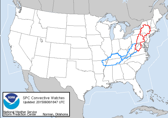
Before we finished the menu and product intro, SPC had already issued mesoscale discussions followed by watches covering all of our areas.

SPC watches valid at the beginning of EWP operations day 1.


-Kristin Calhoun

Week 5 Coordinator

Tags: None

Daily Summary: Week 4, Day 4

The final day of forecast activities for week 4 didn’t see much change geographically, with groups operating in the Boulder, Goodland, and Hastings CWA’s. The Goodland group would later move to Dodge City as activity to the south looked a little more promising. Once again, the Boulder group found the PGLM total lightning Flash Extent Density and Lightning Jump information to be quite valuable in monitoring fluctuations in storm/updraft intensity. One particularly strong storm near Simla, CO produced a tornado from which we were able to view live streaming footage (see image below). Activity in the other CWA’s, was a little slow to develop, giving participants ample time to evaluate the pre-convective products.

– Bill Line, SPC/HWT Satellite Liaison and Week 4 EWP Coordinator

20150604_190539


Tags: None

Monitoring cells moving toward the panhandle of OK & SW KS (DDC)

Noting three strong clusters of thunderstorms moving NE close to the dry line across northern Texas into the panhandle of Oklahoma and southwest Kansas.  These cells have had a history of producing large hail and strong wind gusts.  The lead cell across Texas county has been weakening over the last 15 minutes or so, but could still produce gusty winds and small hail.  Two more clusters will approach southern portions of the Dodge City CWA over through 9 PM CDT.

KDDC_0.5Deg_5Jun15_0010Z

CoonieCatEye/Jason Williams

Tags: None

Lightning Jump Miss

This is a case where I was surprised that there was not a lightning jump. The most that the lightning jump algorithm went up to was 1 sigma. However, we can see in the bottom right panel that the prob severe was gradually increasing (up to 78%). The PGLM data was showing what you could refer to as a ‘jump’ as flash density went from 14 to 29 to 38 to 53.

PGLMvsLJ

-Helen Hunt

Tags: None

7 sigma lightning jump precedes tornado development by 16 minutes

seven_sigma_tornado

We have been tracking a persistent supercell near Simla, CO for the past couple hours.   The lower left panel shows a seven sigma lighting increase, followed by a three sigma increase preceded the eventual tornado development by around 15 to 17 minutes.  It is thought the vertical stretching of the updraft into in the mid levels as indicated by a significant increase in lightning eventually may have manifest in the lower levels by eventual development of a tornado.

John Pendergrast

Tags: None

PGLM Utility

I am finding the PGLM lightning data to be very helpful in detecting lightning before there are any cloud to ground flashes. This data would be helpful in the Columbia, SC FA when storms are approaching outdoor events. It would allow us to give people a heads up sooner than CG data can. The animation below shows the PGLM Surface Flash Extent image overlaid with the 1-min NLDN lightning plot. Near Denver, CO, you can see how the PGLM data picks up on lightning much earlier than the NLDN first CG strike appears (16 minutes earlier!). 16 minutes is critical when it comes to trying to move a large number of people out of an event.

PGLM(Click image to see animation)

As far as other uses for the PGLM data, I’m not sure that it’s something that I would actually use after CG lightning appears and when I’m trying to decide whether or not to issue a severe thunderstorm warning. At that point, I think it would be useful to have the PGLM data incorporated into the ProbSevere data rather than looking at it on it’s own.

-Helen Hunt

Tags: None