Quick update to a previous post. Like before, the first image shows GLM Event Density and the second shows base reflectivity with ProbSevere. It took ProbSevere’s tracking algorithm around 15-20 minutes to splitting the storms into multiple ones. I would have been awesome if it happened earlier, but I’m not complaining. It happened quicker than I thought it would.
Tag: ProbSevere
Will these storms split finally in ProbSevere?
Below are a few images for a long-lived storm in Pecos County that is starting to split. The first image shows GLM Event Density with two separate hot spots while the second image shows base reflectivity with ProbSevere contours. It will be interesting to see if/when the ProbSevere tracking algorithm will splits the storm into two storms rather than one merged storm.
Probsevere initialization
Elevated convection moving out of SE NM has entered an area of better instability/moisture/CAPE/etc and is strengthening. ProbSevere detected this strengthening and the values of the ProbSevere continue to ramp up.
Not issuing SVR because of ProbSevere performance
I’m pretty confident that a few of these cells given core heights and storm environment probably have real world warnings on them at the moment, but I’m holding off due to the performance of prob severe hail and tor through the day today. We’ll see….Particularly the northern storm in the CWA as it is more discreet than the storms near Lake Meredith.
-icafunnel
Tornado Development in N LUB CWA – ProbSVR & NMDA Performance
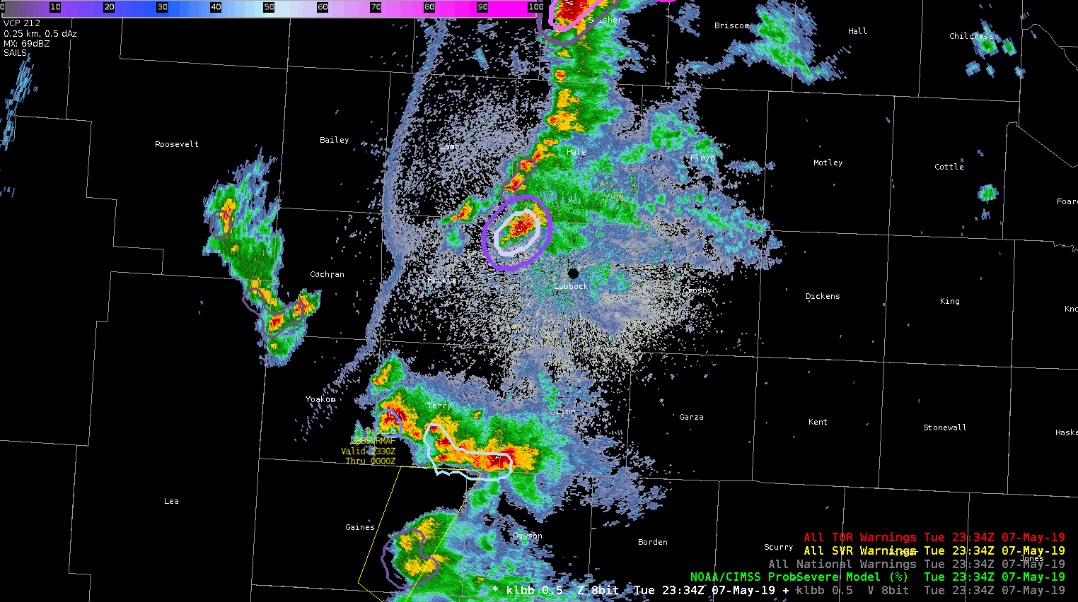
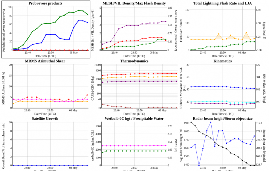
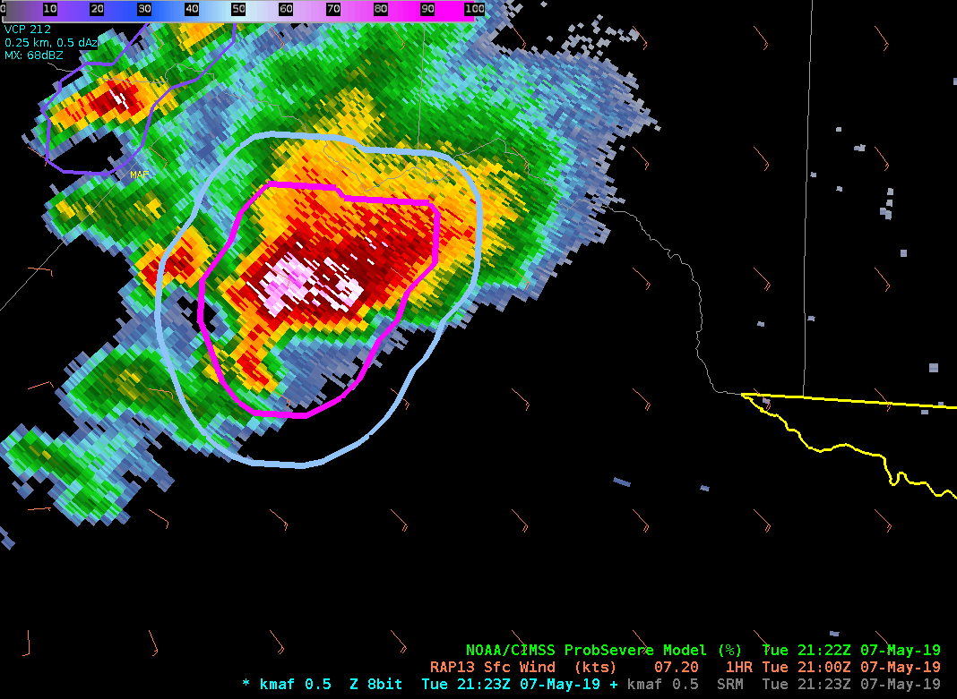
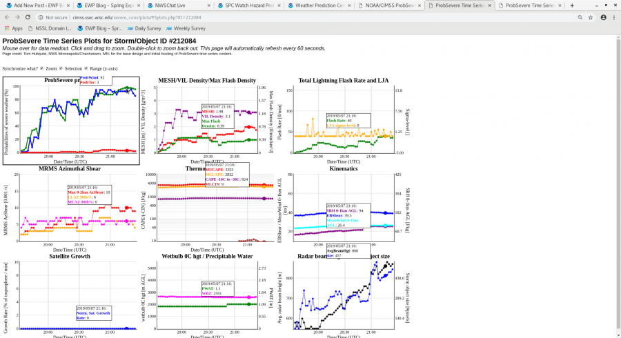
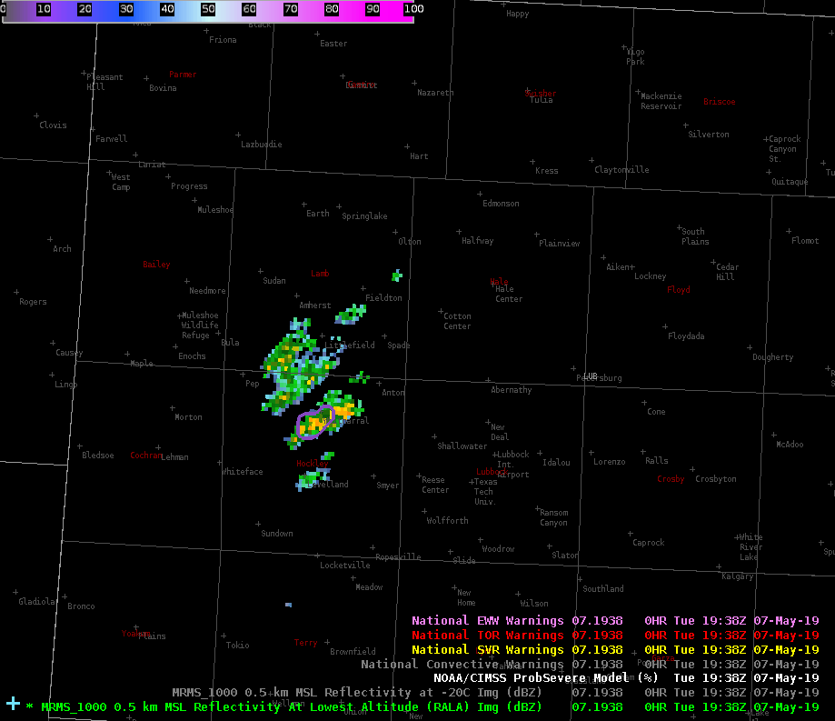
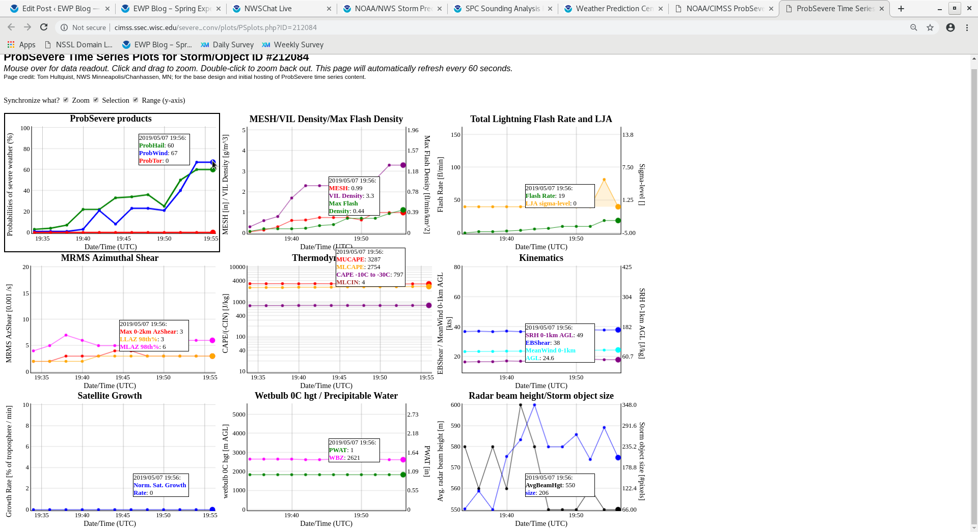
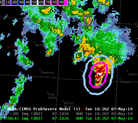
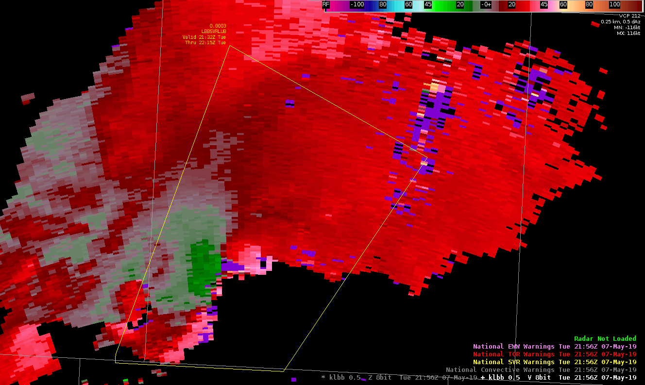
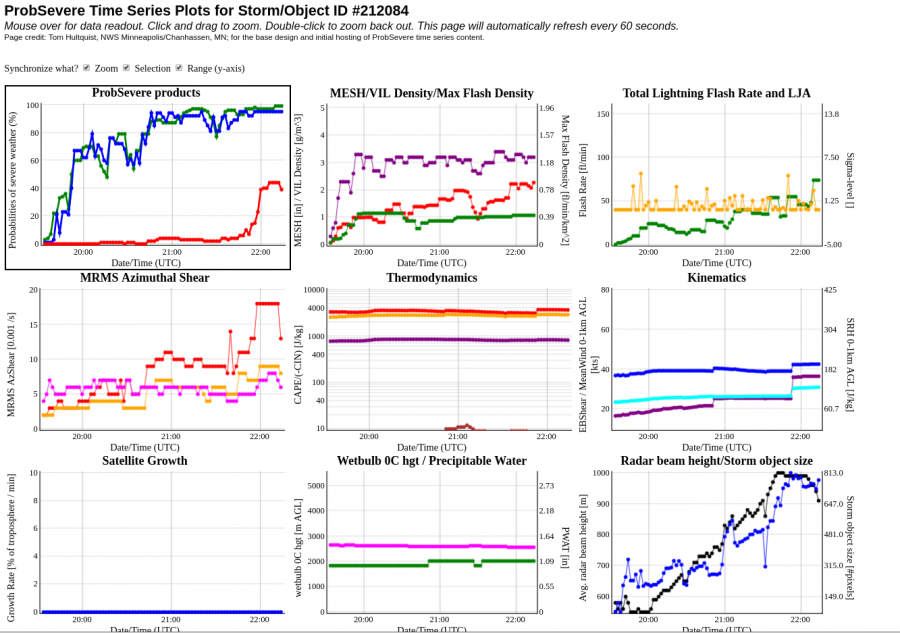
When the reported tornado developed in Swisher County in the northern portion of the LUB CWA at 5:12 PM, it was preceded by increases to the ProbTor and AZShear products by several minutes. Initially, I believed these algorithms to be picking up on sidelobes in the lowest levels of the radar scans, as noisy velocity data was being recorded in areas where reflectivity values were small. You can see these artifacts in and around areas of purple haze in the animation below. However, these products verified their jumps with a brief tornado touching down. It was reported to look relatively strong while on the ground with multiple vorticies visible at the time. It was short-lived, however, seeming to dissipate relatively quickly after touchdown.
The NMDA also did well picking up on this circulation before tornadogenesis, but I had some questions regarding the data quality in the low-level detection prior to the tornado.
#ProtectAndDissipate
Evolution of ProbSevere
I am finding the all hazards version of ProbSevere to be extremely useful as a situational awareness and decision making tool. Here is a short animation of the evolution of ProbSevere thresholds for a storm near Kermit, TX.
Below is a timeseries for the same storm…
A loop of the ProbSevere thresholds provides a quick look at the potential hazards, but it becomes even more powerful when you combine it with the timeseries.
Prob Severe Trends help with decision-making over rural area
Quick ramping up trend of TOR prob strengthened my confidence in this TOR warning in northern Pecos County, despite lack of reports from rural area. Jumped from 16% to 44% to 63% to 78% within 4 scans.
ZDR_Arcophile
Web ProbSevere Table Cutoff
A small cosmetic issue, but I noticed that the Table Display from ProbSevere gets cutoff on the top row, and covers the axis information on the last row. Also had some difficulty zooming out at times, but may have fixed the issue but unselecting option to synchronize ranges.
#ProtectAndDissipate
ProbSevere Progression with intensifying storm
I like seeing the progression of the storm on the ProbSevere page, showing the trends of developing convection. You can see how the increases of ProbHail and ProbWind parallel certain parameters like MESH, VIL, and Flash Rate parameters. It’s also interesting to see what’s not being utilized or loaded into the page such as Sat Growth Rate.
With some MRMS data being loaded into the ProbSVR model, one possible addition to the parameters could be Vertically Integrated Ice (VII) vs VIL. Have found in operations to be a very good indication for strong updrafts above the FZL. Hail and Wet Downbursts have been correlated with very high values of VII (above 25-50 kg*m^-2).
#ProtectAndDissipate
ProbHail Detection shows increased accuracy over MRMS MESH
LSRs showed 1.5″ hail fell in Dumas, TX. Just beforehand ProbHail increased to 83% just beforehand. MRMS showed some spotty 1+” calculations but only to the SW of Dumas. Flash Rate also showed an increase just before the Severe Hail fell in Dumas.
#ProtectAndDissipate