An official website of the United States government
Here’s how you know
Official websites use .gov A
.gov website belongs to an official government
organization in the United States.
Secure .gov websites use HTTPS A
lock (
) or https:// means you’ve safely connected to
the .gov website. Share sensitive information only on official,
secure websites.
With warning operations already underway for western Oklahoma, forecasters are deep into their storm analysis.
One of the more interesting features they have been picking up on is the consistent signals between the pGLM lightning trends and values from the MESH algorithm as well as the 3D-Var derived updraft fields.
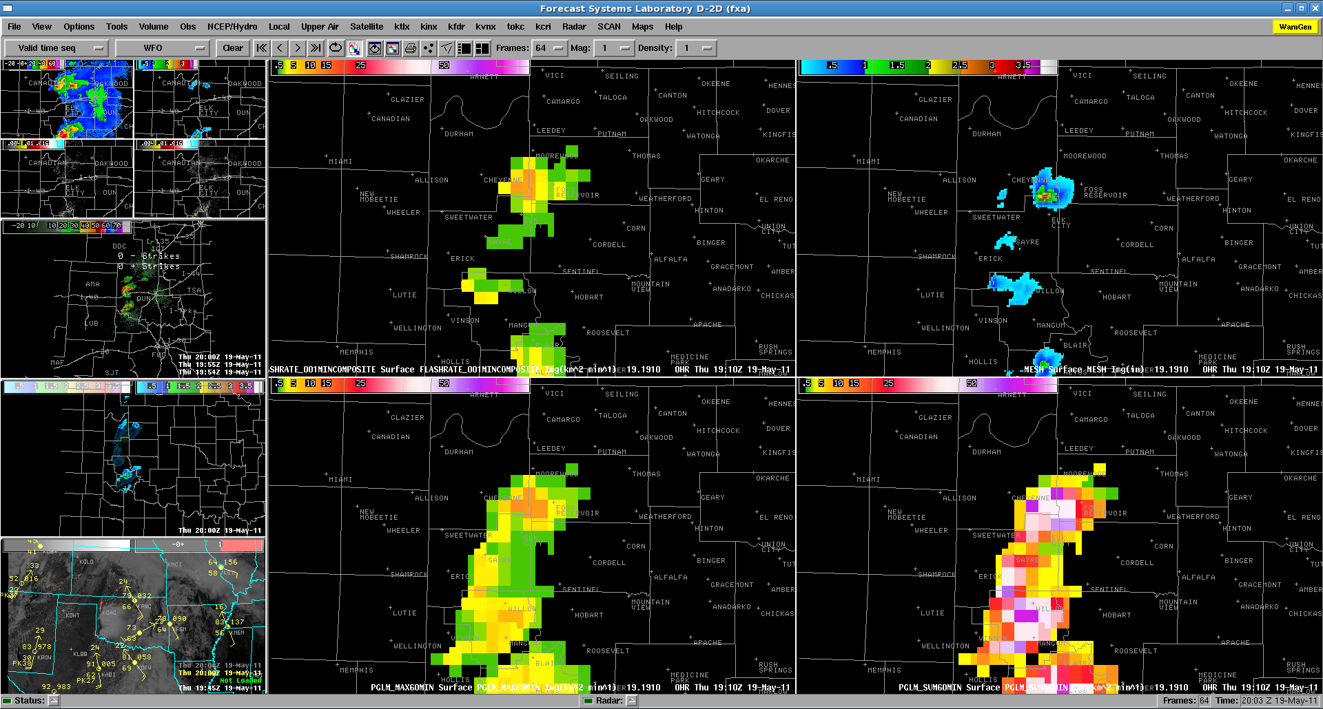
This was well illustrated by the storm north of Elk City moving from Beckham to Roger Mills county. At approximately the same time ~1900-1915 UTC, the lightning rate increased from 5 to 15 flashes per min (per pGLM grid box, not per storm) as MESH ramped up and updraft increased within the 3D-Var product. Shortly after this increase, both the pGLM and MESH values decreased with this storm (the 3D-Var updraft values also showed this, but with a bit of a time lag).
pGLM flash density and MESH values at 1910 UTC on 19 May 2011
Also of note, prior to losing NLDN data, with the storms seemed to be producing relatively little CG lightning. In this case, the pGLM data was definitely giving a better view of the electrical activity and storm intensity. (1 to 1.75 in hail has already been reported across West and SW Oklahoma).
Area of focus will be KS/OK, where dryline convection is forecast by all high-res models. There are timing differences between SPC WRF, HRRR, and OUN WRF…with OUN WRF and HRRR convecting earlier. Late morning OA indicating that cap has weakened to under 25 j/kg along and east of dryline so initiation before 20z possible near and south of Red River. Later initiation expected farther north across west-central and northwest OK, and with diurnal backing and low-level jet intensifcation, early this evening, intensification and tornado potential will increase by 23/00z.
Primary area of concern will be northwest Oklahoma into south-central Kansas (OUN-ICT CWAs) where tornadic potential will be higher and overall coverage expected to be greater. Although instability will be substantial farther south, better shear/LCL values will be seen farther north across nw OK into srn KS. This idea, with much greater updraft helicity forecasts, is supported by OUN WRF. Any convection in SW OK/NW TX is fcst to occur fairly early with weak cap…but not develop particularly strong or rotating updrafts. Concern that if a large area fires too early that may limit additional convectiv e development over nw OK or s-central KS due to cirrus debris. Still…low-level jet strengthening by evening may be enough to help support stronger convection in KS.
18Z position of dryline is just east of DDC to GAG/CDS/SNK. Little in the way of eastward mixing is expected today given deeper moisture to its east and strong jet/ht falls to its west. If storms can get going over west-central and northwest Oklahoma, they should have a better chance of survival off/east of dryline with much better flow over that region.
Despite some degree of uncertainty in timing and exact locations for supercell development in the srn Plains today…high res model guidance and lack of jet cirrus are giving us more confidence that deep convection will in fact develop in a few spots along dryline compared to yesterday…and thus it makes sense to stay focused on the OUN/DDC/ICT CWAs throughout the day…rather than spending any time at all evaluating products in the mid-Atlantic, where shallow convection under persistent upper low is expected to fire again with diurnal heating. In fact some very shallow convection already occuring and overall severe threat looks very minimal there.
19/0100Z: Supercells over Crowley and Kiowa counties. Kiowa county storm still shows strong/deep mesocyclone with attendant large hail/damaging hail risk. There was a brief land spout reported with storm early in life cycle, but appears that it has evolved into a more HP-type storm with decreased tornado potential. 0-2km Az-shear has weakened the past 30 minutes with this HP transition. Although MESH is indicating less-than-severe-size hail, there are reports of 1″ to 1.75″ hail with the Kiowa county storm. Hgt 50dbz above -20C and estimated dbz at -20C would support the larger hail. kbrown
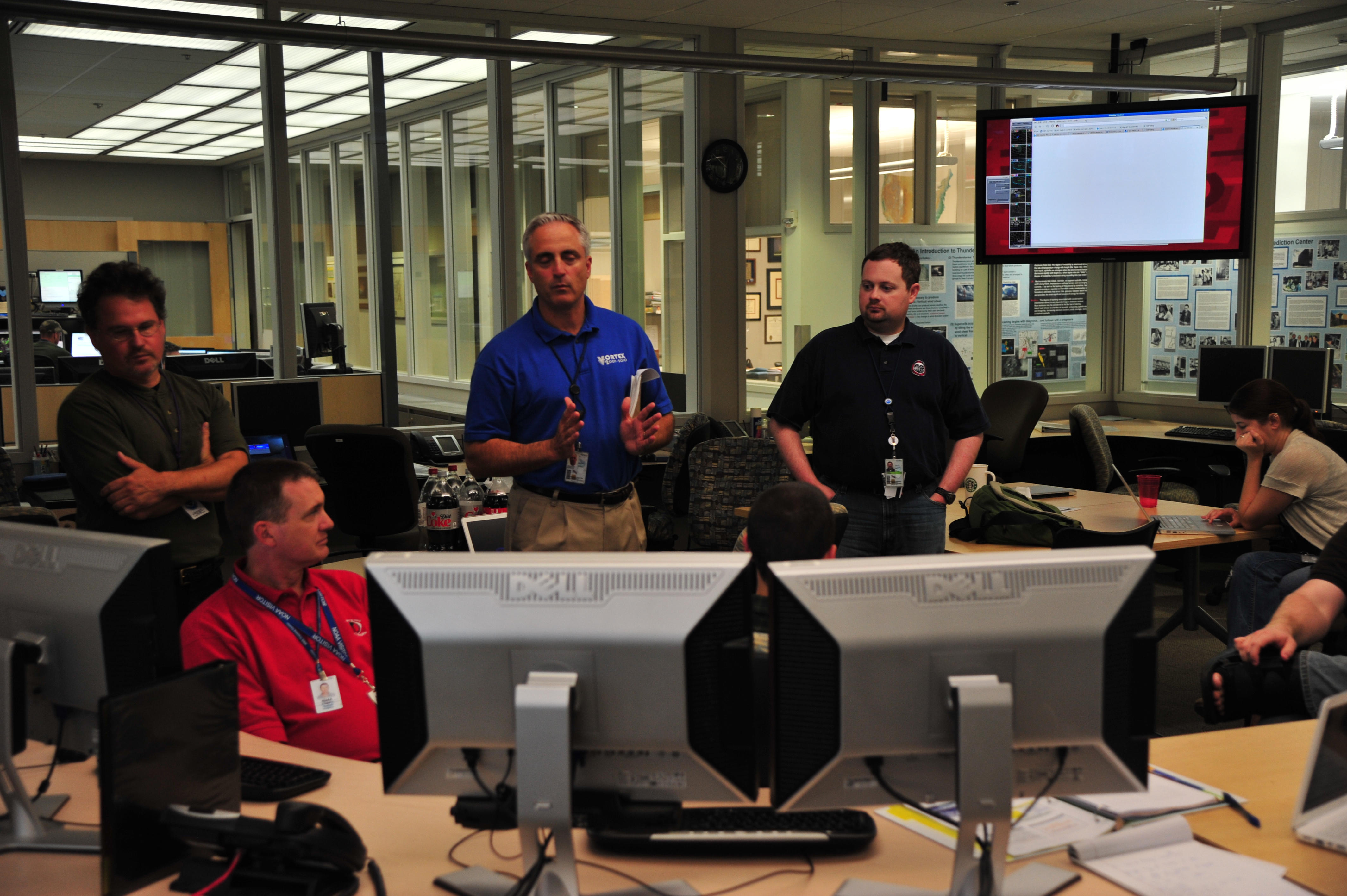
As we waited agonizingly for convection to initiate in our Central Oklahoma Domain (and as of this writing, we are still without storms), we were paid a visit by Don Berchoff, Director of the NWS OS&T.
Our discussion with Mr. Berchoff included:
the need to continue improvements in Convective Initiation (both sensor and model based)
using multi-sensor blending for more holistic storm interrogation
his thoughts on the coming of AWIPS2 and the utility for extensibility
the need for improved analysis and visualization tools in light of the 12 fold increase in data flow
“Fortunately” the weather “cooperated” with us and everyone in the room was able to engage in the discussion.
We had Kevin D. Jessica and Bill forecast our area and issue an AFD. We have decided for the sake if getting “clean” CI and OUN WRF activities, we are focusing on the OUN area.
2355Z Update: Although OUN-WRF continues to generate well defined supercells east of dryline across central Oklahoma, confidence very low due to cooling boundary layer. Dryline is just beginning a shift westward so will need to watch it for just a little while longer. 19/0100Z.
OUN-WRF, since 18z run, has consistently shown signal for convective development just west of OKC metro. Embedded supercells, with southern flank 2-5km updraft helicities 200+ m2/s2 and deviant motions. 20-21z runs want to bring supercell through Norman 23-2330z with southern flank of this storm shifting south and turning right toward Ada. Model has been too eager to develop convection, but depiction of central Oklahoma impacts continues.
Brief convective element over western Major county and weak echoes across southwest Oklahoma from wildfire. Will continue to monitor CI products and trends of ounwrf. kbrown 2215z
2330Z Update: UAH CI indicating possible development across Garvin and McClain counties. There does appear to be an HCR in this location but we believe that the edge of thin cirrus clouds are causing algorithm to detect cloud cooling that is not real. Looks like we are going to move operational area to eastern Colorado where there is a lone supercell. kbrown
2230Z Update: Got a hit off of the UAH CI over southern Comanche county where there are weak echoes aloft (15-20dbz). These echoes are associated with a wildfire plume, however.
2140Z: Brief UAH CI detected across north-central Oklahoma in cloud streets (1832Z), but no subsequent echoes were detected.
Although there has been several hours of cu/tcu formation near and east of dryline, CI algorithms have not detected CI across OUN domain. From 20Z to 2115Z this is actually a good thing since no echoes have developed (good case of low false alarm). Before the CIMSS CI became contaminated with Ice Cloud Mask, there were a few hits for CI on leading edge of incoming cirrus across northwest Oklahoma between 19Z to 20Z. No echoes were subsequently detected.
Isolated CI hits from the UAH algorithm did accurately depict some elevated echoes over the OK/AR border but no lightning occurred. Leadtime for echoes was 15 to 30 minutes. kbrown
Morning surface analysis shows surface low pressure over the northern TX panhandle, with a warm front extending ESE across northern OK and multiple drylines…one over western TX with dewpoints in the 20s behind it, another over western OK separating air with dewpoints in the 40s to the west and lower 60s to the east. Aloft, the 12Z NAM indicates mid level energy ejecting from the western closed low, with a mid level shortwave moving into southeast CO and southwest KS late in the day, with a weaker southern extension moving into western OK…while the northern TX low intensifes and retrogrades into northeast NM. NAM forecast soundings also show an 800 hPa capping inversion eroding late this afternoon over western OK.
With the eastern dryline already into western OK and a little farther east than the NAM forecast, think best chance for convective initiation will be over a narrow corridor in west central OK, beginning about 21Z-22Z, especially where low level convergence will be maximized near the intersection of the dryline and warm front just northwest of OKC. This plus strong veering wind profiles and SBCAPE values up to 2500 J/kg support idea of isolated surface-rooted supercells capable of producing large hail and tornadoes during this time, becoming elevated later this evening as they move east of OKC where the cap should hold. The 14Z HRRR and 12Z SPC WRF also lend support to this idea.
A much more conditional severe threat exists farther northwest into southeast CO and southwest KS north of the warm front, where lift will be better but instability more elevated in nature as the cap holds. Farther east across eastern OK, models (especially the OUN/SPC WRF) generate waa-induced showers along and north of the warm front, but instability is meager and do not expect CI algorithms to perform as well in this area.
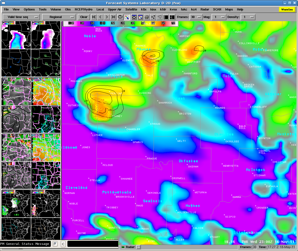
Taking a look at high resolution simulated reflectivity, the RUC HRRR has been consistent in its past few runs of a lone supercell initiating and then propagating east. The NSSL WRF is similiar in this idea, though generates several training supercells. Both are in agreement for an area North and west of Norman. The 15Z OUN WRF was consistent with the 0z SPC 4 km WRF in not generating convective activity…and keeping things confined to weak echoes east of OKC. Now, a look at the 16z OUN WRF is now suggesting supercellular convective initiation similiar to the NSSL WRF. It indicates, Max column hail values in excess of 40 kg/m2, Updraft helicity in the 2-5 km layer indicates in excess of 300 m2/s2, and we are now seeing convective initiation from OUN WRF reflectivity. Timing of convective initation looks to be in the 21-23z time frame. The image below is the 16z OUN WRF model simulated reflectivity forecast at 23z, the first run to initiate convection over NW Oklahoma. Note also the model places updraft helicity in the correct conceptual model location, with the max hail slightly removed. Max column hail (integrated graupel) values greater than 40 kg/m2 and Updraft helicity in the 2-5 km layer in excess of 200 m2/s2 are indicative of strong mesocyclones, with is consistent with the high CAPE and strong low and mid level shear environment.
OUN WRF 7 hr forecast of Simulated Reflectivity (img), Max Column Hail (black), and Updraft Helicity (red)
Therefore, it looks at this time with the plethora of data around OUN that this will be our area of focus this after to test the convective initiation products and to monitor the progresssion of the OUN WRF and other hi-res models, despite additional convective activity possible in SE Colorado.
Ongoing thunderstorms in the Mid Atlantic may serve as a possible alternative location in addition to SE Colorado, should convective activity fail to materialize in the southern plains. MUCAPE 500-1000 J/kg, effective bulk shear 30-40 kt there, and cold pool aloft with 500 hPa temperatures -18C to -20C are supportive of locally severe storms from the Delmarva northwest into southwest PA and WV…with the main threat large hail. Low LCL’s and localized/marginal 0-1km SREH of 100 m^2/s^2 also suggest brief tornado potential in new storms via stretching of rotating updrafts.
Around 2330z we switched from the LWX area to BOU where storms have developed and become severe. There have been reports of a ‘landspout’ tornado near 00z.
Bill and Jessica have mentioned the utility of the updraft field (Merged W Composite) as being an interesting tool for landspout-type environments.
It should be noted that compared to the updraft field looked quite “off” (incorrect) with the storms in the DC domain, but look much better in the Floater (BOU) domain. Perhaps the 3DVAR we are using is better “tuned” for a supercell environment and the sub-severe storms in the DC area provided a bit more of a challenge.
We will operate for another hour or so and then begin surveys.