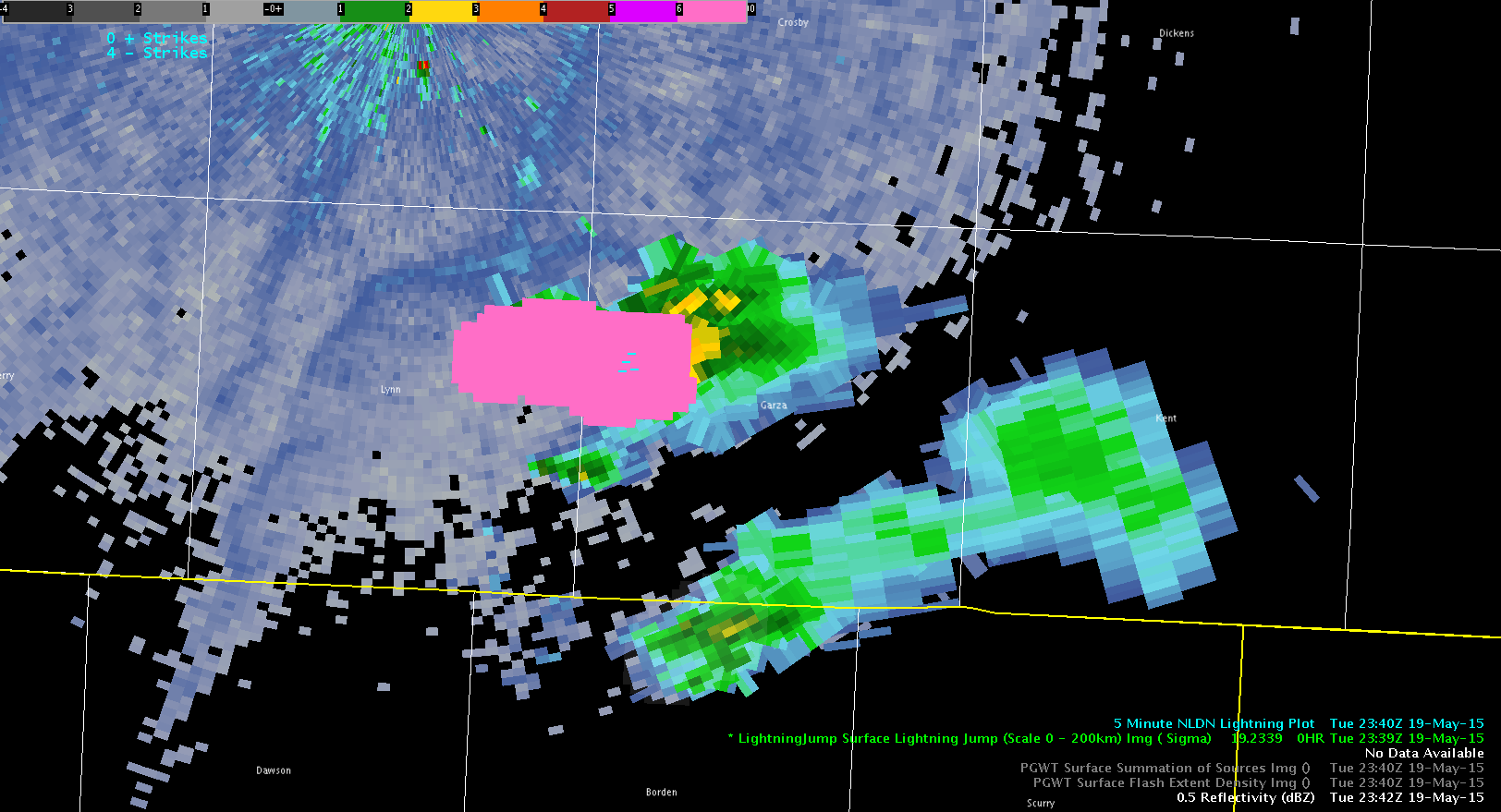
Lightning Jump Sigma 6 leads to…

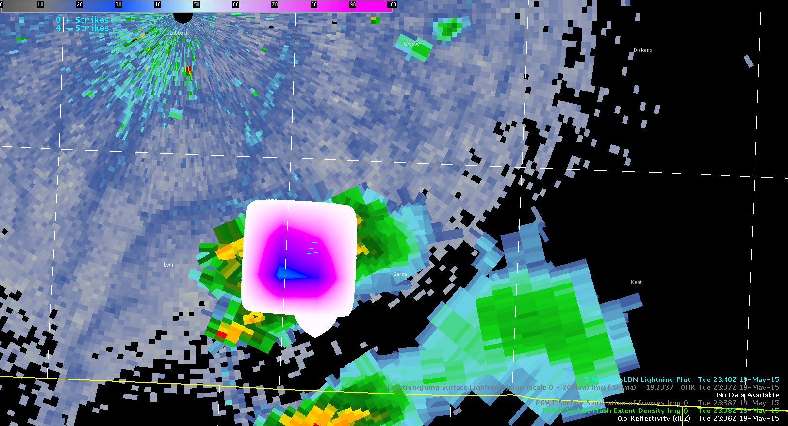
A cell developing over the southern portion of LUB CWA showed a Lignting Jump value of 6 sigma. Upon further investigation it went from almost no lightning (2nd image below) to  a flash density of 35. The storm proceeded to quickly pulse down (with a  decrease in lightning). Thus…the sigma 6 in this case was not indicative of severe. The storm followed the same trend as most of the isolated convection in LUB today.

One suggestion with the Lightning Jump Algorithm/pGLM data is to be able to display a time series as is done with the ENI Lightning Data. Another idea to better gage trends in Flash Extent Density and Summary products is to show previous values when sampling with the mouse pointer (or a change in value from previous reading).


-snowstrm

PGLMDensity

Tags: None

ENI Flash Rate Values and Track Help In Tornado Warning

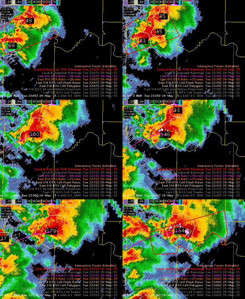
A tornado warning was issued on a strong storm which was intensifying with a slow ramp up in lightning flash rate from around 100 to ~200. The storm appeared to be bending its track to the east more (right mover) and this was confirmed with the use of the history DTA rate track of >50/min. This assisted me in drawing my warning polygon downstream (bent it more east [like Beckham]). The loop provides a summary of my thoughts and the tornado warning referenced is the second tornado warning issued at 2255Z.

Continue to find alerts are not useful and are more of a distraction – prefer the raw data displays. Feel the loop below is a very useful display for ETN data in the warning process. The cell tracking did struggle with expansion and contraction as the northern storm provided a larger polygon (merger). But, I was still able to gain useful trend data even with the bouncing cell polygon due to the merging.

RedRiver_CellFlashRates_DTARocky

Tags: None

SVR in AMA CWA at 2230UTC

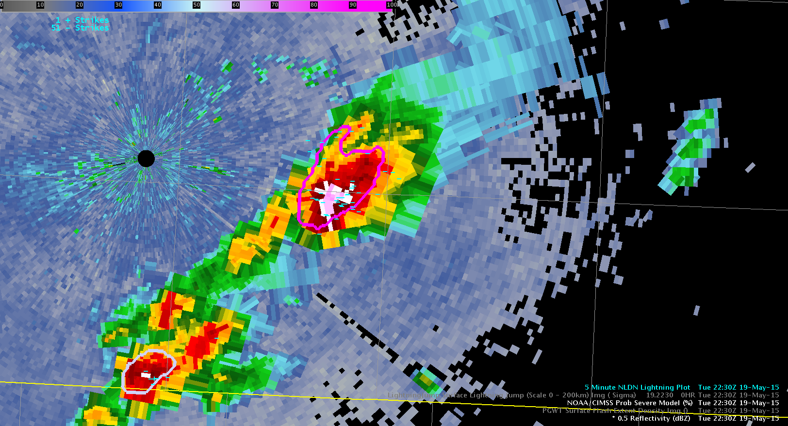
Issued an SVR for a storm which has observed (estimated) 1″ hail and 60-65mph winds over an hour prior to this in Randall County. The storm maintained intensity as it continued eastward.  ProbSevere held steady at over 90% with MESH over 2″.

-snowstrm

ProbSevere

Tags: None

GOES-R CI performance across FWD


CI 22z

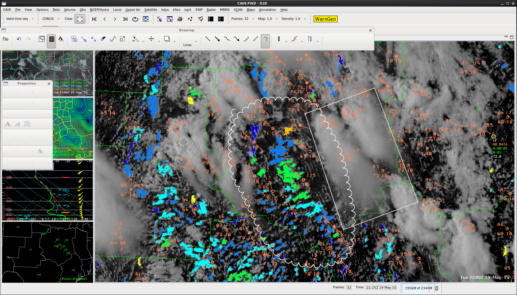
GOES R-CI has had a tough time detecting CI across eastern portions (rectangle) and far NW portions of the CWA so far due to more in the way of convective debris and cirrus in these areas. Those areas are where the severe storms have occurred.

It has done well detecting null areas for development. CI has never gotten above 60 percent in the “clearer” areas (scalloped area)…which based on skill threshold should not have had CI.

Pickles

Tags: None

Severe Hail report associated with collapse in ENI lightning flash rate

ENI flash rate 22z

Quarter size hail was reported by this cell at 2145z in Kaufman county. This was coincident with a collapse in lightning activity after an earlier significant spike.  The lightning collapse and coincident severe reports has been evident in a couple of marginal and severe storms across eastern portions of the cwa. The short-lived activity across eastern portions of the cwa makes sense because of the weaker deep layer shear and therefore more pulsey behavior.

Pickles

Tags: None

Overlapping ENI Cell Polygons affecting DTA?

A potentially severe storm (seen below) tracking through Young County…with 70 DBZ at 35 kft. -20 C level which is at 24 kft. Warning was issued at 2125z based on this intensity.2132 6.4 degree dyx yar

ENI is maintaining a significant thunderstorm alert on this storm (lower right panel of 4 panel seen below). This may be due to overlapping cell polygons (upper right panel of 4 panel seen below). The combo of the two cell flash rates would have put it over the 40 flash/min at 2018z (threshold for a dangerous thunderstorm alert). CIMSS svr prob has been steady at 94 % since that time..

2130z ENI YAR

Lightning flash rates (below) with this cell have been pulsing with an upward trend…but there have been some noticeable spikes.

2139 z lightning rate Yar texas

Pickles

Tags: None

Confirmed Large Tornado and Lightning Data

&A confirmed large tornado near the Red River matched very well with the ENI lightning data, showing two minimums when the radar SRM data was strongest (corresponding to when the confirmed tornado reports were coming in).

The image below shows SRM at 2059z when the rotation signature was strongest. The time series below a local minimum at 2055 to 2100z. This fits the conceptual model.

lightning_tornado_grandfield

lightning_timeseries

Tags: None

Severe storm in Young county

Image of a severe thunderstorm in Young county in the extreme northwest portion of the DFW CWA.  This cell had a 94% SVR PROB rate with 62 dbz to 45000 feet.  This cell also saw a good spike in the Earth Networks lightning time series.severe storm

Tags: None