
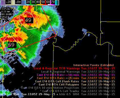
A tornado warning was issued on a strong storm which was intensifying with a slow ramp up in lightning flash rate from around 100 to ~200. The storm appeared to be bending its track to the east more (right mover) and this was confirmed with the use of the history DTA rate track of >50/min. This assisted me in drawing my warning polygon downstream (bent it more east [like Beckham]). The loop provides a summary of my thoughts and the tornado warning referenced is the second tornado warning issued at 2255Z.
Continue to find alerts are not useful and are more of a distraction – prefer the raw data displays. Feel the loop below is a very useful display for ETN data in the warning process. The cell tracking did struggle with expansion and contraction as the northern storm provided a larger polygon (merger). But, I was still able to gain useful trend data even with the bouncing cell polygon due to the merging.
 Rocky
Rocky