Brewster Co TX storm not so Punky but modified NUCAPS was

The modified NUCAPS sounding over Brewster Co TX was more representative of the actual conditions at 20Z versus the regular NUCAPS. A dryline was positioned very near the point of interest and convective initiation eventually occurred  near the boundary in ~1000 ML CAPE air around 22Z.

Modified NUCAPS sounding w/ surface Td near 47F. MLCAPE ~ 1000 J/kg.

Regular NUCAPS sounding w/ surface Td near 54F. ML CAPE ~2000 J/kg.

RTMA Td analysis. Point H is where the NUCAPS sounding was taken from.

GOES-16 RGB at 2150Z showing CI occurring near the dryline.

Best option available?

Below is an example of a case where prob severe my offer the best option for a warning decision. This storm is outside of the best RADAR coverage available; however, strong development has been seen on Satellite imagery for an extended period of time. In a case like this, the PROB Severe Algorithm may be the best option for a warning decision, based on the data available.

South Beach

GLM Min Flash Area…Best Practice

Figure A

Figure B

Best Practice:  Look at lower left image on both Figure A and B (GLM Minimum Flash Area), notice Figure B has interpolate turned on which makes the product less useful since outer edges also have minimum values.  The GLM Minimum Flash Area of interest jumped out much better on Figure A without interpolate turned on.


Figure C

Blending both All Sky Sfc-900mb PW and Visible satellite imagery together for convection initiation in western TX panhandle.

Az Shear – the goods and bads

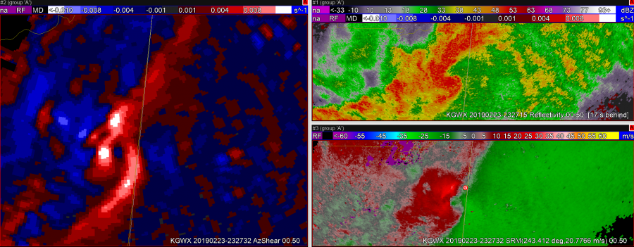
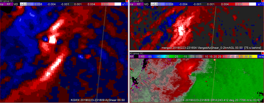
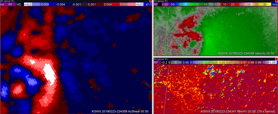
Photo above shows a double maximum in AzShear. One of these is clearly colocated with a TOR on ground via CC. However, velocity shows two very different situations, possible strong tornado on ground versus convergence along the RFD gust front. If you were just looking at the AzShear product, both of these areas would be cause for concern, when in fact the impacts are extremely different. Would be nice to be able to differentiate between extreme high values of AzShear near a tornado versus more broad convergence on any wind shift area.


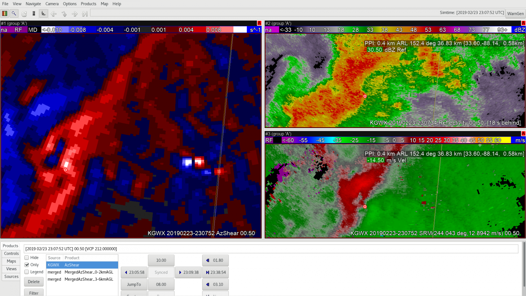
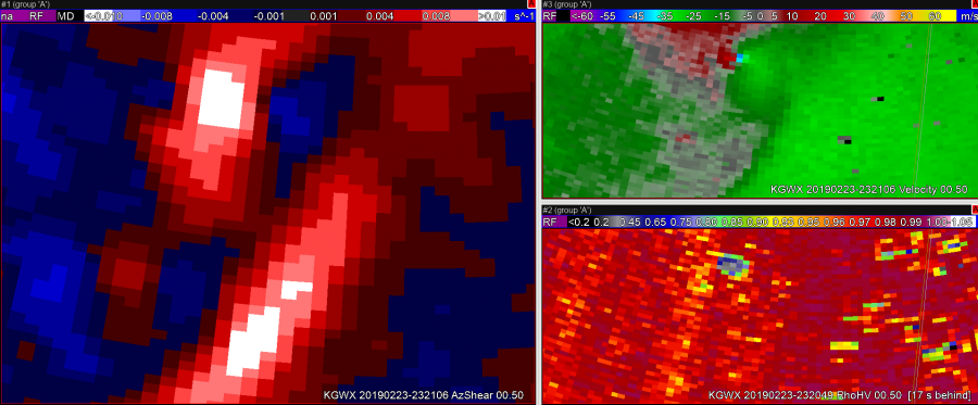
This next image shows a region where the AzShear maximum is too broad. This may simply be a color table issue, but clearly there is an area within the white region where a tornado is on the ground, and other regions within that max where only general convergence is occurring.


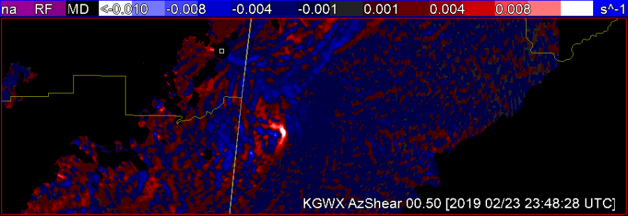
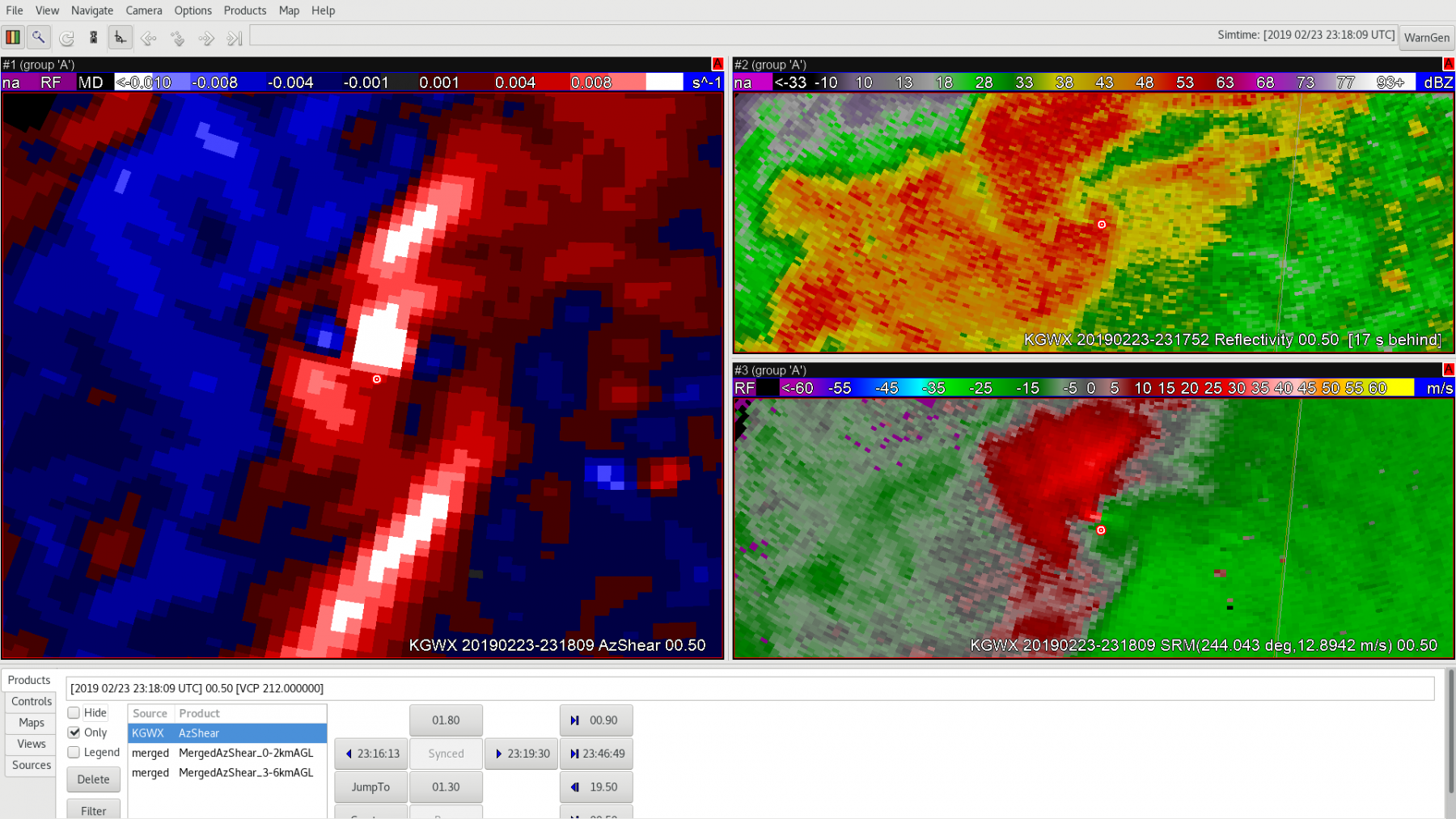
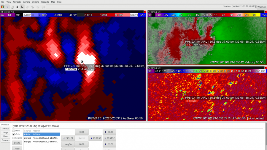
This image shows a location where some ground clutter is producing a false positive and negative AzShear couplet. Mathematically it makes sense to see this here given the V data, however to an untrained eye or someone just solely depending on AzShear you could be led astray.


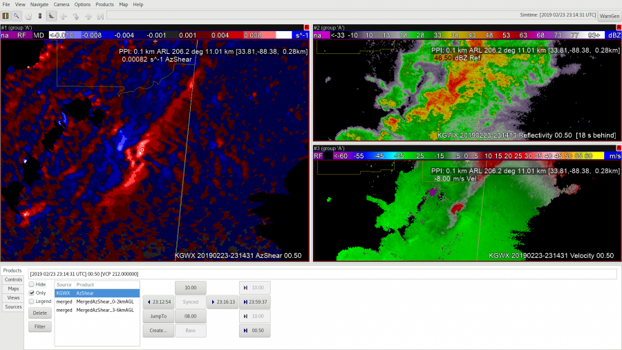
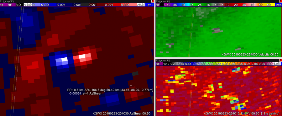
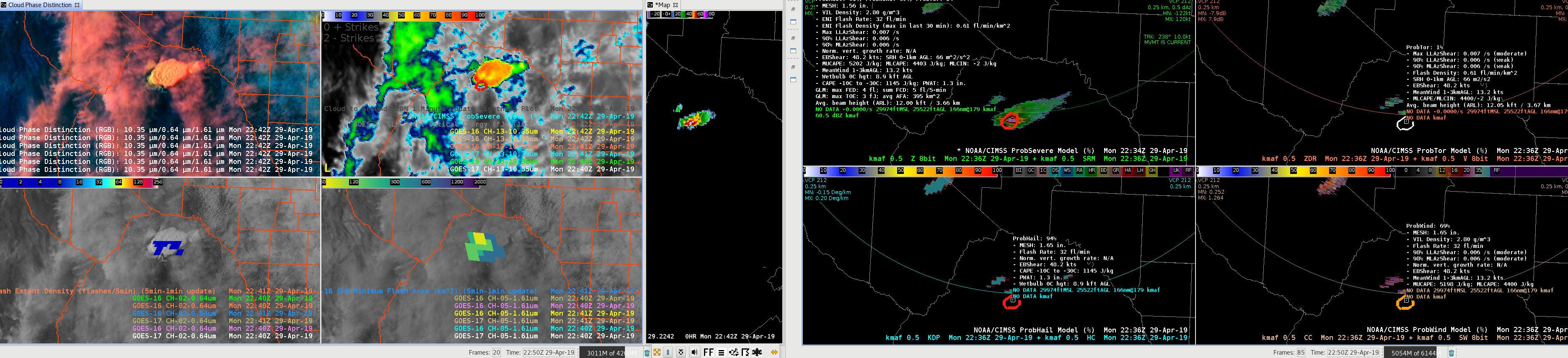
A positive of AzShear is that it can highlight areas of potential concern down the road. The above frame was just one of several frames showing strong convergence and high AzShear values preceding a second tornado from the main cell 10 minutes later. This could be particularly helpful in QLCS storm modes where convergence and shear increases in a broad sense along the main line prior to tornadogenesis. Also in this particular case, the V data was not entirely conclusive that convergence was increasing. AzShear was very conclusive here.


Dusty Davis

AZShear case 2/23/19

First impression of the single radar AzShear……display is rather noisy with lots of couplets…many not associated with any storm. Perhaps if had the option to filter out negative values (blue) so can focus on positive values only would make for easier digestion of data and enhance SA.   IN current state of product, would have have to be sure to compare to base velocity data, etc.

Azshear did  help draw my attention to potential cyclic nature of the storm and picked up on increasing shear to northeast perhaps a little sooner than if I had not been looking at it.  Pickup up on second circulation and locked on to it very well as second tornado(?) developed.

Azshear also seemed to highlight the shear along the RFD/Flanking line rather well.

0-2 km merged product provided similar information.  Did not have good feel for 3-6 km product yet.

Again, biggest drawback is the noisiness of Azshear.  I could see where this could distract from true area of shear associated with developing mesocyclone. Color enhancement could be improved as well.

Quik TWIP


AZ Shear

Az shear while noisy can be used to  quickly draw you attention to features of interest. It can point you to the center of strongest rotation very quickly helping a forecaster determine the area under the greatest threat from a tornadic circulation or where it is most intense.

South Beach

02 Feb 2019 AzShear Case

AzShear helped identify a new developing circulation ahead of the reflectivity signature. This provided added SA in watching for new meso development. It also “might” help identify quick spin-ups along a surging bow echo or RFD. At first glance, false alarms appeared to be minimized but this was a fairly classic supercell case with at least one strong tornado and clear debris signature.

— S Coulomb

23 Feb 2019 AzShear

The single radar AzShear product seems particularly useful in the warning environment, especially as an SA tool. At 2307Z the AzShear product highlights an area of enhanced shear near the inflow region of a supercell SW of a KGWX (immediately north of the little red marker) whereas the base velocity has no discernible couplet. Roughly 11 minutes later, at 2318Z, the couplet was clearly visible on base velocity with AzShear even more pronounced value. As an SA tool, AzShear shows promise for highlighting potentially problematic areas before fully reflected in the base products. This product has the potential to help with warning lead times, especially if the storm is in a favorable tornadic environment.

— Stanley Cupp

2307Z AzShear, base reflectivity (top right), and storm-relative velocity (bottom right)

2318Z AzShear, base reflectivity, and storm-relative velocity

AZ_shear 5

Can see the strong AZ-Shear signal developing along the zero-isodop in the velocity product.


One big benefit of the AZ-Shear product is that i can see is increasing shear along the zero isodop line.  This caught my attention of increasing rotation compared to looking/waiting for the velocity product  couplet to develop.  This seems more pro-active in this case to possibly anticipate earlier tornadic development. -Jake Johnson


66


6

23 Feb 2019 Case – AzShear

The single radar AzShear provides good continuity with persistent mesocyclones. It also highlights well meso handoffs. The single radar AzShear is far superior to the merged product. The merged product does not provide as smooth of a track and suffers from obvious different depictions of the circulation from varying ranges and sample times giving a more blotchy appearance and larger overall signal.

— S Coulomb