Noticed that the NMDA was glitching out in some of the upper levels of distant storms. Ironically, despite all the false detections, it didn’t identify some of the actual rotations, distant or within the CWA that were ongoing.

#ProtectAndDissipate
Official websites use .gov
A
.gov website belongs to an official government
organization in the United States.
Secure .gov websites use HTTPS
A
lock (
) or https:// means you’ve safely connected to
the .gov website. Share sensitive information only on official,
secure websites.

Noticed that the NMDA was glitching out in some of the upper levels of distant storms. Ironically, despite all the false detections, it didn’t identify some of the actual rotations, distant or within the CWA that were ongoing.
#ProtectAndDissipate
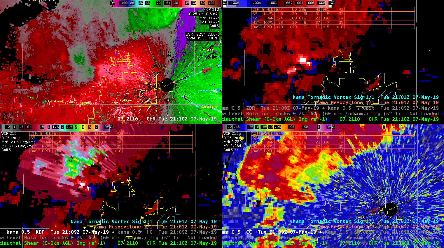
A tornado was reported to have touched down at 2127z. Per the AMA radar (report was in northern LBB’s CWA), the NMDA (bottom left) was the only MDA to indicate a meso in the area the tornado was reported. The Legacy MDA (top left) and DMDA (top right) indicated a meso with the cell to the west of the primary meso.

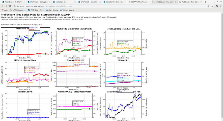
A small cosmetic issue, but I noticed that the Table Display from ProbSevere gets cutoff on the top row, and covers the axis information on the last row. Also had some difficulty zooming out at times, but may have fixed the issue but unselecting option to synchronize ranges.
#ProtectAndDissipate
A strong supercell in Lubbock’s CWA is the first example I have witnessed of the NMDA (bottome left) performing better than the legacy MDA (top left). The DMDA (top right) followed the meso at times, but the NMDA seemed to perform the best in this particular situation. The legacy MDA failed to pick up on a meso at all.
Merged AZShear picking up on the low-level rotation nicely!
(Don’t know why images are being weird here)
#ProtectAndDissipate
Issued TOR warning with this imagery and supplemental storm chase video showing lowering base and RFD.
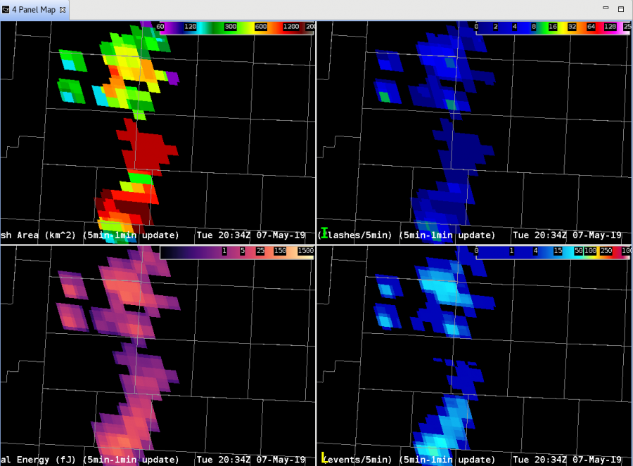
Well, one piece of the puzzle was solved. A second large flash in the Minimum Flash Area product occurred between Lubbock and Amarillo, around 1500 km2. To see what was going on, we now take a look at the difference between GOES-16 GLM:
and GOES-17 GLM:
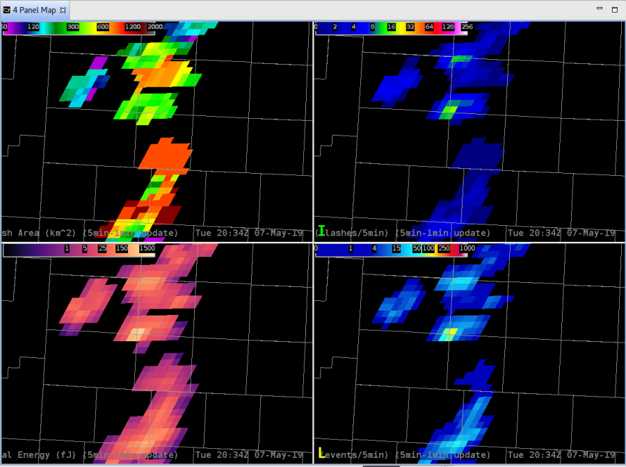
After a LOT of going back and forth, we realized that the color table for Flash Extent Density had the alpha at zero for anything around 1.0 to 1.244. SO, the previous example that showed no FED actually DID have data associated with the large flash; it was hidden (my bad!). Fixing the color table to plot any data greater than zero at the darkest color blue and…voila! The large flash now does show a FED of 1.0. So that problem is now solved.
However, there is still a question as to why that big area flash occurred where it did, when it did, and if it was actually as large of a flash as indicated. Still something to dig into further!
-Dusty
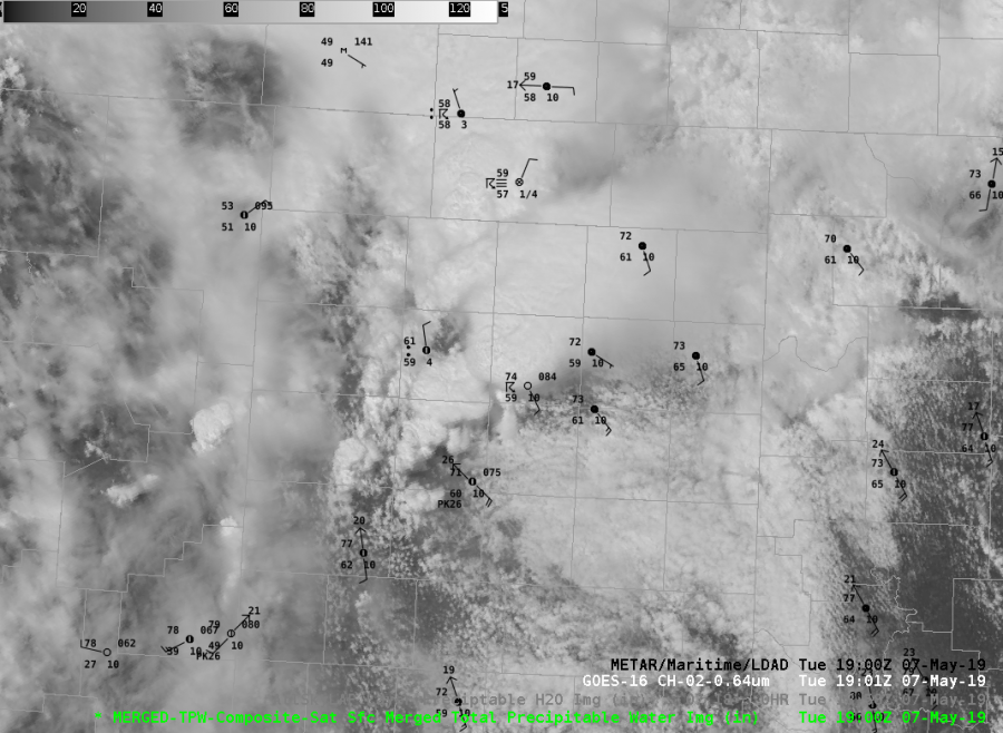
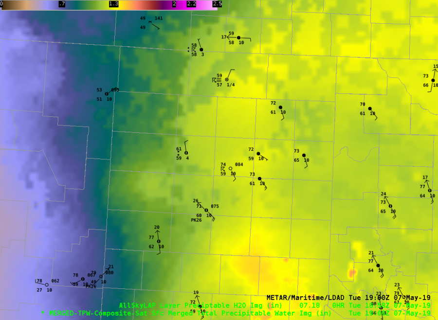
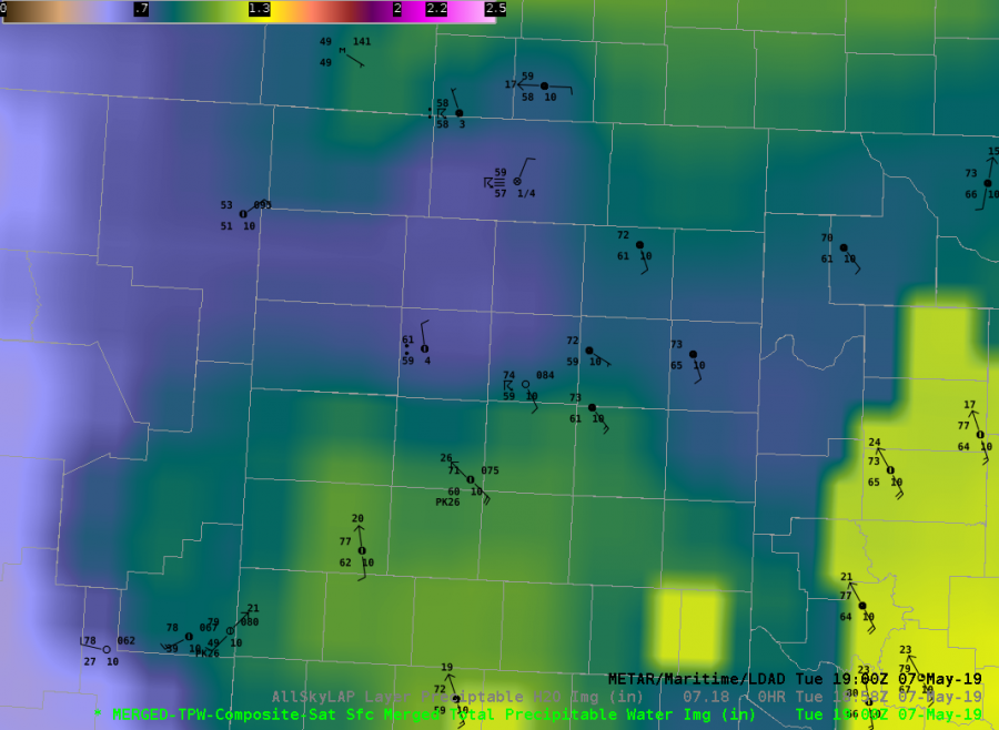
The CIRA Merged TPW and All Sky LAP in the TX panhandle show some differences in the vicinity of the dryline at 19 UTC on 7 May. This is a cloudy region so the retrievals are either GFS (All Sky LAP) or advected polar microwave (Merged TPW), The All Sky LAP TPW shows a moist panhandle, with values in green / yellow (1″ or above). The Merged TPW indicates lower values in green / purple, or about 0.7″. Surface dewpoints range from 59-65 F, indicating moist air ahead of the dryline.
Surface GPS observations from Suominet at three TX stations in the panhandle (Amarillo – 1.0″, Borger – 1.0″, and Canadian – 1.1″) lean closer to the All Sky LAP analysis. An hypothesis for the Merged TPW being low is dry retrievals from higher terrain to the west being advected into the moist sector.
JohnF
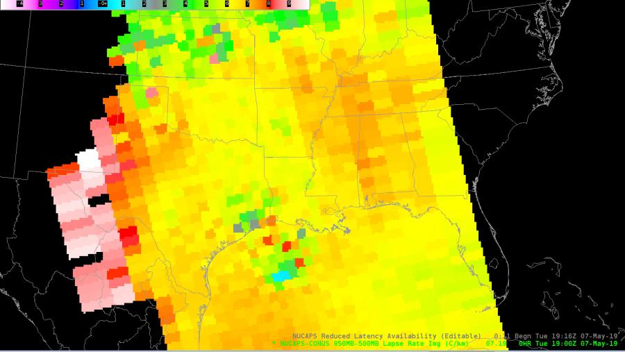
The AllSky H9 PW product showed good advancement of the dryline into West Texas today. Convection quickly developed as the dryline advanced into the Panhandle. 
As an operational forecaster, I like to compare model output, real-time obs, and any additional derived data. This image from the NUCAPES H85-H5 Lapse Rate can potentially help boost one’s confidence in particular synoptic situations. For example, suppose you were expecting a dryline to emerge east across W Texas, but guidance indicated otherwise and sfc METARS were unavailable, using the NUCAPS Lapse Rate products can help determine the location of the dryline (for this particular setup). In this image, values reflect the drier air advancing east leading to steeper lapse rates.