Live Blog – 19 May 2009 (8:54 pm) – PAR/CASA Update

The CASA group is intently analyzing data, and will run up to 9 pm.  The PAR group is providing feedback verbally to the facilitators, and filling out a case study survey.  There will not be time for an end of day debrief, but we plan to hold more discussion at the beginning of the 1 pm briefing on Wednesday.  For now, some of the comments I’m overhearing from PAR include: for storms at long range, please experiment with elevation angles lower than 0.5 degrees; forecasters like the beam overlapping in the horizontal and vertical; forecasters would like to see the reflectivity color curves in WDSS-II display more noticeable breaks at 50 and 60 dbZ for hail threat.

Patrick Burke (EWP Weekly Coordinator, 18-22 May 2009)

Tags: None

Live Blog – 19 May 2009 (8:20 pm) – CASA Group

In viewing the archived CASA data, Rob is bothered by the sector scans from the individual radars at certain elevation angles.  He finds it difficult to trust the data near the sector edges because we are taught to look for dealiasing failures, etc., when traditional radar shows sharp cutoffs.  Additionally, Rob and Mike would prefer to see the entire 360 deg scan at all elevation angles.  They would be willing to accept slightly slower updates in favor of 360 deg scans.

Patrick Burke (EWP Weekly Coordinator, 18-22 May 2009)

Tags: None

Live Blog – 19 May 2009 (7:26 pm) – Nevermind

The strong storm in the Glasgow area weakened when it became elevated north of the warm front.  Other cells tried to initiate along an arcing outflow boundary southeast of the original storm.  These new cells were never a threat to produce severe weather.  Rather than chasing new mediocre cells in western and central Montana, we made the decision to end the IOP, and return to the more fruitful archive cases.

Patrick Burke (EWP Weekly Coordinator, 18-22 May 2009)
Tags: None

Live Blog – 19 May 2009 (6:09 pm) – MRMS IOP – Take II

We’ve reinitialized in the Glasgow, MT, area, as of 6 PM CDT.  A strong thunderstorm coming out of the higher terrain to the west… is now interacting with a warm front oreinted NW-SE across Montana.  The initial cell has shown a weakening trend, but there are other cells coming up along the flanking line…and in the vicinity of the front.  If these cells become potentially severe, we will stick with this IOP.  Otherwise, we may choose to switch to PAR and CASA archive if the Montana activity hasn’t shown us anything by 7 PM.

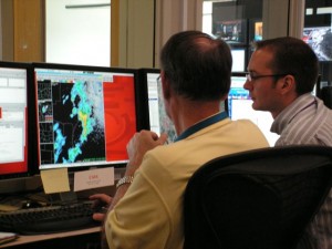
Les Lemon (Left) and Rob Handel (Right) analyze data from the Glasgow, MT, WSR-88D

Patrick Burke (EWP Weekly Coordinator, 18-22 May 2009)
Tags: None

Live Blog – 19 May 2009 (5:20 pm) – MRMS – IOP moving to Montana

Technical difficulties have slowed our progress this afternoon.  One team, Matthew and Mike, were able to view data from Salt Lake City in both D2D and Google Earth.  The Warngen functionality was compromised, though, and the group did not feel the convection warranted warnings.  They would have issued special weather statements, if possible.  The second group, Rob and Les, did not have a functioning data feed, so instead carried on a fruitful conversation with a group conducting satellite-based research.  We are now taking a dinner break while Kevin works to correct the technical problems.  Hopefully when we return there will be a window of opportunity in which to issue warnings over the Glasgow or Billings, MT, area.  If not, we will return to archive cases of PAR and CASA data.

Patrick Burke (EWP Weekly Coordinator, 18-22 May 2009)
Tags: None

Live Blog – 19 May 2009 (2:55 pm) – Thoughts on Radar Coverage in the West

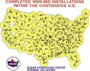
During the outlook briefing, Mike Vescio noted that our Southeast Montana target is in an area where radar coverage is either poor or non-existent.  The Utah/Idaho/Wyoming target is also in a region of relatively sparse coverage affected by beam blocking.  This may not be a detriment to the experiment, however.  Kiel Ortega points out that one of the expected strengths of Multi-Radar/Multi-Sensor output should be to more easily facilitate severe weather warnings in areas like the Intermountain West, where forecasters need to make the most of every piece of data possible.

Patrick Burke (EWP Weekly Coordinator, 18-22 May 2009)
Tags: None

Outlook – 19 May 2009


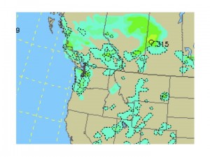
We begin today wrapping up loose ends from Monday.  Forecasters will navigate some archived LMA data for the first time, just to get a feel for the data.  We will then spend 45 minutes completing an archive CASA case that was suspended at the end of yesterday, while the PAR group conducts a second archive case.  At that point, around 3:30 pm CDT, we hope to attempt a real-time Intensive Operations Period (IOP) for the Multi-Radar/Multi-Sensor project.  Today’s target is the Intermountain West, and perhaps the plains of southeast Montana.

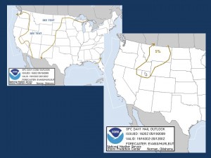
Day 1 Categorical Convective Outlook and Hail Probabilities from the SPC issued 1630Z

The region from northern Utah across Idaho/Wyoming and into Montana, is in the warm sector ahead of an advancing Pacific cold front and associated upper level trough.  Scattered thunderstorms are forecast to form within a deeply mixed boundary layer.  Weak to low-end moderate CAPE and cloud-layer shear of 25 to 40 knots should be sufficient for organized multicell storms with marginal wind and hail threats.  There is a chance for a supercell in southeast Montana if storms can root close to the surface…where greater dewpoints to near 50 F have pooled along a quasi-stationary front.

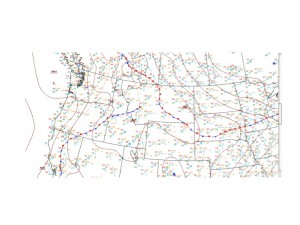
HPC Surface Analysis Midday

NAM 6-hr Precip from 18-00 Z May 19, 2009.  Image from UCAR

NAM 6-hr Precip from 18-00 Z May 19, 2009. Image from UCAR

Patrick Burke (EWP Weekly Coordinator, 18-22 May 2009)
Tags: None

Summary – 18 May 2009

Our Week 4 forecasters were not deterred by bleak prospects for organized severe weather.  Instead, they arrived ready to tackle archive events and whatever pockets of real-time opportunity present themselves.  With four projects in the HWT this year, the task of training is quite lengthy, and it was an accomplishment to push through all of the training on the first day.  We have a very inquisitive and well-read group this week; they asked many questions during the training, often citing references.  They seemed to take in all of this material eagerly.  Although I heard no negative comments, I wonder as a coordinator, if it might be information overload to push through all 4 programs in one day.  I might have preferred to have a Day 1 IOP, and complete the training necessary for that IOP, while saving half of the training for Day 2.  In our case, though, we are now well versed, and the team of Mike and Rob have completed a PAR archive case; Les and Matthew are paused in the middle of a CASA archive case, ready to resume Tuesday afternoon.  We also hope to run an IOP for Multi-Radar/Multi-Sensor research in the northern Rockies.

Patrick Burke (EWP Weekly Coordinator, 18-22 May 2009)

Tags: None

Live Blog – 18 May 2009 (8:44 pm) – Comments from PAR team

Rob and Mike note that the PAR data is giving them more lead time on severe weather signatures compared to the 88D (KTLX, which they are viewing side by side with PAR).  Mike says, “We’re ahead of the game.”  And when asked if the PAR data is bombarding them perhaps too quickly, they say, “No!”  They wouldn’t mind if it came in even faster.

Patrick Burke (EWP Weekly Coordinator, 18-22 May 2009)

Tags: None

Live Blog – 18 May 2009 (8:42 pm) – Comments from CASA Team

The CASA team first familiarized themselves on visualizing and navigating the data with one brief case study.  Matthew noted that in the CASA data he is seeing familiar storm-scale processes happening at sub-storm scales of time and space.  They are now moving on to a displaced real-time archive case in which they will issue mock warnings.  The team read over the available environmental data to great length.  They appreciate this type of data in lieu of a traditional shift briefing.  They suggest that in addition to seeing a central Oklahoma upper air sounding, they would also like to see soundings from the surrounding area, numerical measures of severe weather parameters on those soundings, and an analyzed surface map.

Patrick Burke (EWP Weekly Coordinator, 18-22 May 2009)

Tags: None