Severe Threat over Minnesota This Afternoon

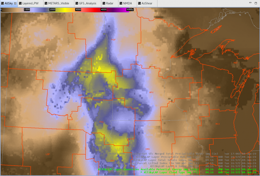
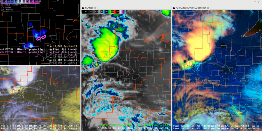
Ongoing complex of thunderstorms pushing into south central MN this hour.  Have a new set of thunderstorms forming in what AllSky is showing as a higher CAPE environment along the outflow pushing out from this complex.  ProbSevere has picked up on this cell as well (near Milan)…showing a Hail chance of 55% now and growing quickly.  Will monitor the downstream growth of both systems.

Mid-Level Mesos

The merged AzShear product has done a solid job keeping up with low & mid level rotation tracks so far this afternoon in the Texas panhandle. Most of the storms over the last hour have exhibited weak low level rotation but much stronger mid level rotation. The merged AzShear product showcases it well with much hotter values on the mid-level product compared to low level. This also matches well with the threats observed so far with several reports of large hail, but any tornado threat has yet to materialize.

Dave Grohl

Decrease in GLM lightning activity coincident with 2 inch hail report

A storm just northeast of Amarillo developed quickly along a frontal boundary, and quickly showed supercellular characteristics with mid level rotation and a 65+ dbz core reaching about 35 kft MSL. 2 inch hail was reported with this storm during this time. GLM data again shows a decrease in both Flash Extent Density (top right) and Event Density (top left) show a notable decrease in GLM lightning activity while ground based radar remains fairly unchanged, and both the IR satellite presentation (bottom right overlaid on visible imagery) and radar data (not shown) indicate the storm maintained intensity and if anything, had strengthened a bit.

-64BoggsLites

Significant Difference Between Operational and New MDA

Thursday afternoon convection continues to cook in the northern Texas panhandle. Several mesocyclones were detected by the different algorithms along a broad, down radial shear zone. The values from the operational MDA (bottom left) and digital (bottom right) were very high, topping out at 24+ LLRV for all three mesos detected at the lowest scan. That is much higher than values seen for some tornadic supercells earlier in the week, and does not match the velocity data with no strong, tight couplets evident. The new MDA is much more restrained and actually has the strongest RV values above the lowest scan, which matches up with the velocity data much better as the values should be lower with broad, weaker areas of rotation.

Dave Grohl

NMDA Tracking well thus far in Tx

Below is a loop of NMDA on the top left, and the operational MDA on the top right. The NMDA seems to be tracking the mesocyclone moving north of Amarillo fairly well as object 2. It does occasionally identify spurious mesos as well (the smaller circles which pop up), but it does seem to have done a better job of identifying and  tracking the primary meso when compared to the operational MDA.

-64BoggsLites

GLM Observations in the Tx Panhandle

A supercell moving northward along the dryline over the Texas Panhandle region underwent a split over the last 20 minutes or so. Preceding the split, there was a notable decrease in 5 minute GLM Flash Extend Density and Event Density.  After the split, there were to notable maxes in both of these products. However, in the GLM Minimum Flash Area, this trend was not observed due to the more coarse resolution of the product. Better resolution may have helped identify both updraft regions within the 2 storms after the split. Additionally, a downward trend was noted in 5 Event Density and Flash Extent Density despite no real change in the ENTLN lightning activity. A loop of GLM data and IR/Vis depicting  this storm split is below.

-64BoggsLites

TX Panhandle AllSky CAPE

A moderate risk for severe weather across portions of the Texas Panhandle today. Some convection is already on going along and north of a nearly stationary front stretched from the northern Panhandle into Kansas. Despite the cloud debris, the All Sky layer CAPE product still looks to be doing an acceptable job of analyzing the degree of instability present in the area. 18z values near Amarillo match well with the 18z special sounding at KAMA with values generally between 1600-2000 J/kg. The blotchiness of the all sky product between clear/cloud cover is a bit distracting, but the difference in values is a small enough magnitude that it does not compromise the forecaster’s ability to use the product.

Dave Grohl

Lightning Jump in GLM FED, but not Earth Networks data

Storms continue just after 7pm near the Oklahoma/Texas border. A currently severe-warned storm saw a substantial and rapid increase in lightning activity observed by the GLM Flash Extent Density product. However, the ground based lightning network did not follow the same trend and remained fairly steady. The ground based data is more reasonable considering the storm did not experience any sort of significant strengthening during this time period. Earlier discussions with lightning detection experts suggested the low GLM FED count may be due to the location of lightning within the storm updraft region, which could impact how well GLM can sense it. That is difficult for the typical operational meteorologist to consider in real-time since it goes well beyond current training, and leads to decreased forecast confidence in the lightning data.

Dave Grohl

Mesocyclone Detection Algorithms Performance on Marginal Supercell(s)

A cluster to 2 merged supercells traversed across northern Oklahoma this evening. The loop below shows the performance of all three mesocyclone detection algorithms.

The legacy MDA performed the most poorly of all 3 detecting several inaccurate mesocyclones with inconsistent tracking. The DMD performed remarkably well in both tracking and intensity on the main meso  The NMDA experienced occasional dropouts where data was unavailable, but also performed pretty well on this storm. It particularly detected intensity well through the lifecycle of the meso.  The AzShear product also tracked the main mesocyclone very well. The DMDA performed best of all three for this storm  but the NMDA also showed promise. -Atlanta Braves