ProbTor 97% / Is It Useful For a Line?

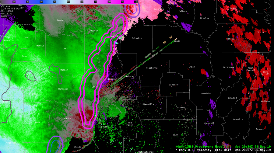
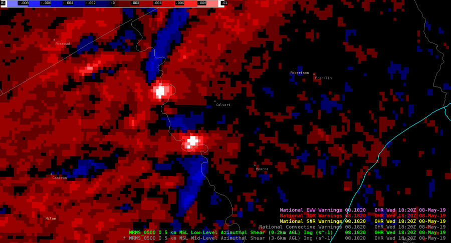
The Prob Tor is 97% for this long line in the SHV CWA. Is that useful as a forecaster? It might seem like it isn’t, but let’s discuss. We’ve been watching circulations along the line through the shift. Early on, we issued several TORs, but in a number of cases, the circulations have been short lived along the segment.

So, as a forecaster or a WFO, you’ve got two ways you can go here in the current environment….

1) You can issue a SVR for straightline wind for the whole segment for a longer length of time (45-60min) given that the environment the line is moving into isn’t changing, and try to keep up with shorter lived, individual TOR warnings for the circulations

-or-

2) You can issue a severe thunderstorm warning for a shorter period of time for straightline wind (30 min) and tag that “lines can produce tornadoes) and see if that characteristics of the leading edge show clearer tornadic signs at some point.

At least the ProbTor alerts you to a decision to be made. It goes both ways in WFO offices in this situation.

Comparison of Operational NUCAPS / Modified NUCAPS

Modified NUCAPS sounding for Bienville county in SHV CWA in advance of line we have severe warnings out for with embedded tornadic circulations.

Comparison of NUCAPS soundings in pre-storm environment in SHV CWA. We’re warning for a bowing segment line with bookend vortices. There are several important differences between the generated soundings, including a better representative moisture profile from the modified sounding given the moist environment, linear convection, precip. loading processes. Also of note is the inversion shown between 900 and 850mb in the operational sounding. Analysis of the RAP13 850 temp fields suggest the modified sounding is more representative of what’s likely occurring. In this instance the NUCAPS modified sounding appears to be a better product for the current environment.


Operational NUCAPS sounding for Bienville county in SHV CWA in advance of line we have severe warnings out for with embedded tornadic circulations.

Here’s an exciting non-case. Hooary!

In this example, Houston County in the far Northern HGX CWA was in horrible radar coverage with 0.5 degree radar scans over 12kft AGL. With the success of GLM FED predicting severe storms earlier in the day this was used to give confidence NOT to issue a warning for this area, despite slight bowing in the sloppy reflectivity and an abundance of activity in the ENTLN network.

#ProtectAndDissipate

QLCS spinup detected by low-level AzShear

QLCS situation just outside of the HGX CWA where low-level combined AzShear spotted two areas of increased low-level shear entering Robertson County. The northern circulation eventually led to  downed trees east of Calvert 12 minutes later, and may have been a tornado, according to the LSR. This product would have given me more confidence to at least have a severe thunderstorm warning out, if not a tornado warning, and would most likely have led to a greater amount of lead time than I would have had otherwise.

ZDR_Arcophile

Tornado Warning Prompted with Merged AzShear

Radar imagery f/ KGRK showed rotational low-level organization within the QLCS. While ProbSevere was putting near 80% for the wind threat with and increase to a 9% for a tornado threat. The Merged AzShear product was showing strong 1D pseudo-vorticity in the area of interest and was used to push the SVR warning w/ Tor possible tag up to a Tornado Warning. Immediately after issuing the warning the circulation seemed to fall apart, however, a couple minutes after the warning a report of a wall cloud with a rope tornado came in through the chat. Lead time may have been nill (also due to not having a Text Workstation up yet), but the warning seemed to have verified thanks to the dependency on the AzShear product. With a single-radar AzShear in operations it would have been possible to increase lead time.

UPDATE:

Going back and looking at the GLM data showed intensification of the cell which spawned the reported tornado before genesis (or at least before the report). GLM FED shows the previously warned cell to the north fading in strength and the intensifying updraft of the cell to the south that prompted a tornado warning.

#ProtectAndDissipate


GLM Activity In Developing Line of Storms

The outflow from the main line of storms was moving west and combined with a strong cell which was spawned off the dryline, resulting in a strong line of storms forming where the two converged. Something that was noted was the delay in GLM FED with the developing convection, where flashes could be seen quickly from the ENTLN. Chalked this up to the optical depth of the storm at the time covering the flashed from the GLM given the extent of cloud-to-ground strikes. Later on, a line of increased GLM FED could be seen.

#ProtectAndDissipate


Increasing GLM activity in a dying storm

At 2330Z, GLM began picking up a signal of increased lightning activity with a storm moving into the LUB CWA. At the time the core was strong with a spike in value in the MRMS VII product, though real-time radar had started to show a weakening storm. (Left panel shows GLM Event Density)

10 minutes later, at 2340 UTC, the storm was deteriorating, yet GLM Event Density continued to increase in this area while ENTLN Total lightning data was decreasing.

After another 10 minutes, at 2350Z, GLM lightning activity continues to breanch eastward despite little reflectivity aloft and ELTLN lightning continuing to decrease in the area.

Finally, at 2352Z, 2 minutes later there’s a rapid decrease in the lightning activity on GLM in the easternmost storm. The Event Density data was the 5min-1min update, and it looked like 1 minutes worth of data was the result of the eastern extension.

#ProtectAndDissipate

Low-level AZ Shear continues to do well

The Low-level AzShear Product continues to do well, increasing significantly in areas where tornadoes were reported, and showing value in areas where looking at Doppler Velocity alone may not show the best picture of the vorticity within the storm (which was pretty messy at this time). However, some limitations I was seeing was 1) latency issues with short-lived circulations which I would hope the single-radar product would mitigate and 2) possibly due to SAILS cuts, the same features are often captured multiple times in the same image (i.e. vorticity along gust fronts and low-level rotations).

#ProtectAndDissipate

Tornado Development in N LUB CWA – ProbSVR & NMDA Performance

When the reported tornado developed in Swisher County in the northern portion of the LUB CWA at 5:12 PM, it was preceded by increases to the ProbTor and AZShear products by several minutes. Initially, I believed these algorithms to be picking up on sidelobes in the lowest levels of the radar scans, as noisy velocity data was being recorded in areas where reflectivity values were small. You can see these artifacts in and around areas of purple haze in the animation below. However, these products verified their jumps with a brief tornado touching down. It was reported to look relatively strong while on the ground with multiple vorticies visible at the time. It was short-lived, however, seeming to dissipate relatively quickly after touchdown.

The NMDA also did well picking up on this circulation before tornadogenesis, but I had some questions regarding the data quality in the low-level detection prior to the tornado.

#ProtectAndDissipate