
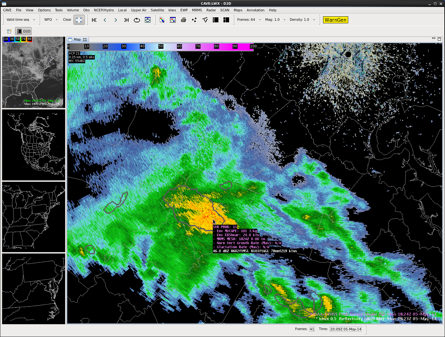
Probability of this cell in VA producing severe wx in the next hour is 1% !!!
Scott Rudge
Official websites use .gov
A
.gov website belongs to an official government
organization in the United States.
Secure .gov websites use HTTPS
A
lock (
) or https:// means you’ve safely connected to
the .gov website. Share sensitive information only on official,
secure websites.

Probability of this cell in VA producing severe wx in the next hour is 1% !!!
Scott Rudge
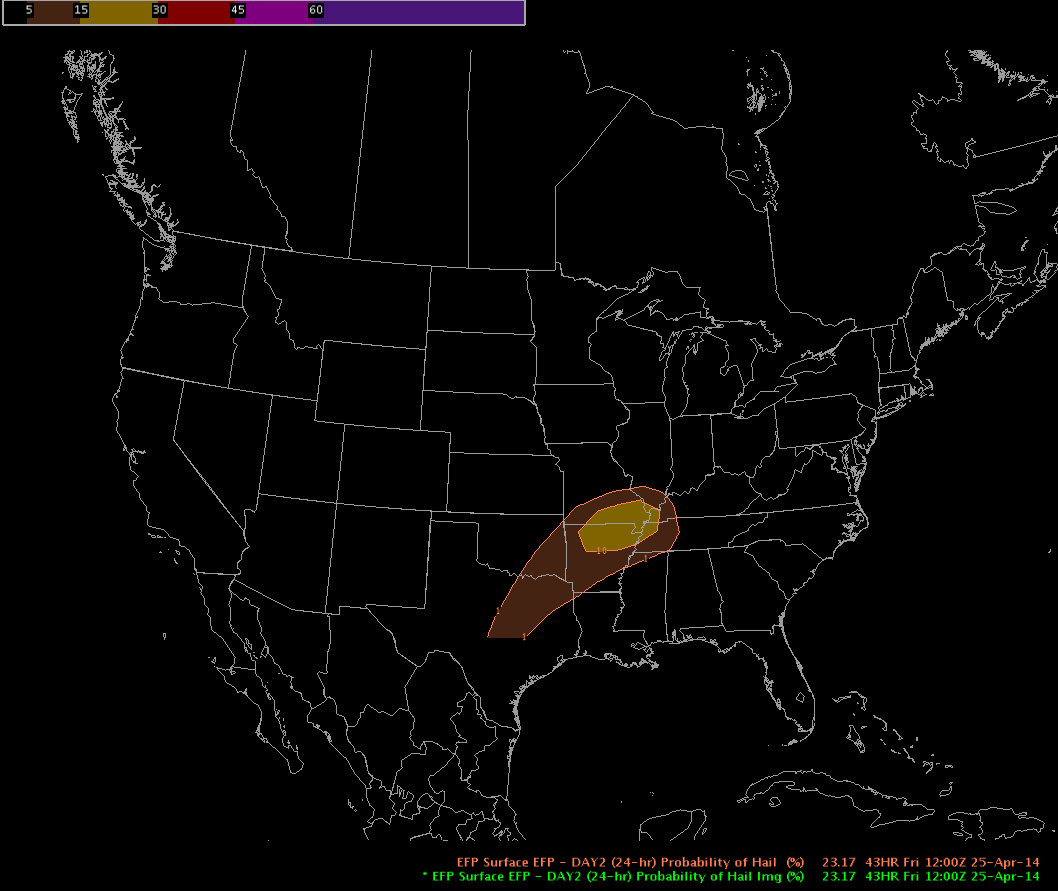
Probability of hail over the next 24 hours.
Scott Rudge
Monday 5 May 2014 begins the first week of our four-week spring experiment of the 2014 NSSL-NWS Experimental Warning Program (EWP2014) in the NOAA Hazardous Weather Testbed at the National Weather Center in Norman, OK. There will be two primary projects geared toward WFO applications, 1) a test of a Probabilistic Hazards Information (PHI) prototype, as part of the FACETS program and 2) an evaluation of multiple experimental products (formerly referred to as “The Spring Experiment”). The latter project – known as “The Big Experiment” – will have three components including a) an evaluation of multiple CONUS GOES-R convective applications, including satellite and lightning; b) an evaluation of the model performance and forecast utility of two convection-allowing models (the variational Local Analysis Prediction System and the Norman WRF); c) and an evaluation of a new feature tracking tool. We will also be coordinating with and evaluating the Experimental Forecast Program’s probabilistic severe weather outlooks as guidance for our warning operations. Operational activities will take place during the week Monday through Friday.
For the week of 5-9 May, our distinguished NWS guests will be John Keyes (WFO Pocatello, ID), Jared Maples (WFO Grand Rapids, MI), Scott Rudge (WFO Rapid City, SD), Kris White (WFO Huntsville, AL), Bruce Thoren (WFO Norman, OK), and Jonathan Wolfe (WFO Charleston, WV). Additionally, we will be hosting a weather broadcaster to work with the NWS forecasters at the forecast desk. This week, our distinguished guest will be Daniel Bickford of WSPA-TV (Greenville, SC). If you see any of these folks walking around the building with a “NOAA Spring Experiment” visitor tag, please welcome them! The GOES-R program office, the NOAA Global Systems Divisions (GSD), and the National Severe Storms Laboratory have generously provided travel stipends for our participants from NWS forecast offices and television stations nationwide.
Visiting scientists this week will include Steve Goodman (NESDIS), Hongli Jiang (GSD), Paola Salio (Ciudad Universitaria, Buenos Aires, Argentina), Justin Sieglaff (CIMSS), and Ed Szoke (GSD).
Kristin Calhoun will be the weekly coordinator. Lance VandenBoogart (WDTB) will be our “Tales from the Testbed” Webinar facilitator. Our support team also includes Darrel Kingfield, Gabe Garfield, Bill Line, Chris Karstens, Greg Stumpf, Karen Cooper, Vicki Farmer, Lans Rothfusz, Travis Smith, Aaron Anderson, and David Andra.
Here are several links of interest:
You can learn more about the EWP here:
NOAA employees can access the internal EWP2014 page with their LDAP credentials:
https://hwt.nssl.noaa.gov/ewp/internal/2014/
Gabe Garfield
CIMMS/NWS OUN
2014 EWP Operations Coordinator
Monday 21 April 2014 begins the second week of our two-week Multiple-Radar/Multiple-Sensor Best Practices experiment in the NOAA Hazardous Weather Testbed at the National Weather Center in Norman, OK. This project is designed to include forecasters in the process of developing training for the Warning Decision Training Branch in how to best use MRMS severe weather products to improve warning decision making. Through a series of controlled experiments using archive and real-time data, forecasters will also help provide data to prove several hypotheses that MRMS products will provide better warnings for the public. Operational activities will take place during the week Monday through Friday.
For the week of 21-25 April, our distinguished NWS guests will be Ray Wolf (WFO Davenport, IA), Rod Donavon (WFO Des Moines, IA), Ashley Sears (WFO New York, NY), and Darren Van Cleave (WFO Sacramento, CA). If you see any of these folks walking around the building, please welcome them! The National Severe Storms Laboratory has generously provided travel stipends for our participants from NWS forecast offices nationwide.
Our support team also includes Matt Elliott, Darrel Kingfield, Jim Ladue, Bobby Prentice, and Greg Stumpf.
Here are several links of interest:
You can learn more about the EWP here:
NOAA employees can access the internal EWP2014 page with their LDAP credentials:
https://hwt.nssl.noaa.gov/
Gabe Garfield
CIMMS/NWS OUN
2014 EWP Operations Coordinator
Monday 7 April 2014 begins the first week of our two-week Multiple-Radar/Multiple-Sensor Best Practices experiment in the NOAA Hazardous Weather Testbed at the National Weather Center in Norman, OK. This project is designed to include forecasters in the process of developing training for the Warning Decision Training Branch in how to best use MRMS severe weather products to improve warning decision making. Through a series of controlled experiments using archive and real-time data, forecasters will also help provide data to prove several hypotheses that MRMS products will provide better warnings for the public. Operational activities will take place during the week Monday through Friday.
For the week of 7-11 April, our distinguished NWS guests will be Kevin Brown (WFO Norman, OK), Pat Spoden (WFO Paducah, KY), Michael Dangelo (WFO State College, PA), and Jacob Beitlich (WFO Minneapolis, MN). The National Severe Storms Laboratory has generously provided travel stipends for our participants from NWS forecast offices nationwide.
Our support team also includes Matt Elliott, Darrel Kingfield, Jim Ladue, Bobby Prentice, and Greg Stumpf.
Here are several links of interest:
You can learn more about the EWP here:
NOAA employees can access the internal EWP2014 page with their LDAP credentials:
https://hwt.nssl.noaa.gov/
Here we go!
Gabe Garfield
CIMMS/NWS OUN
2014 EWP Operations Coordinator
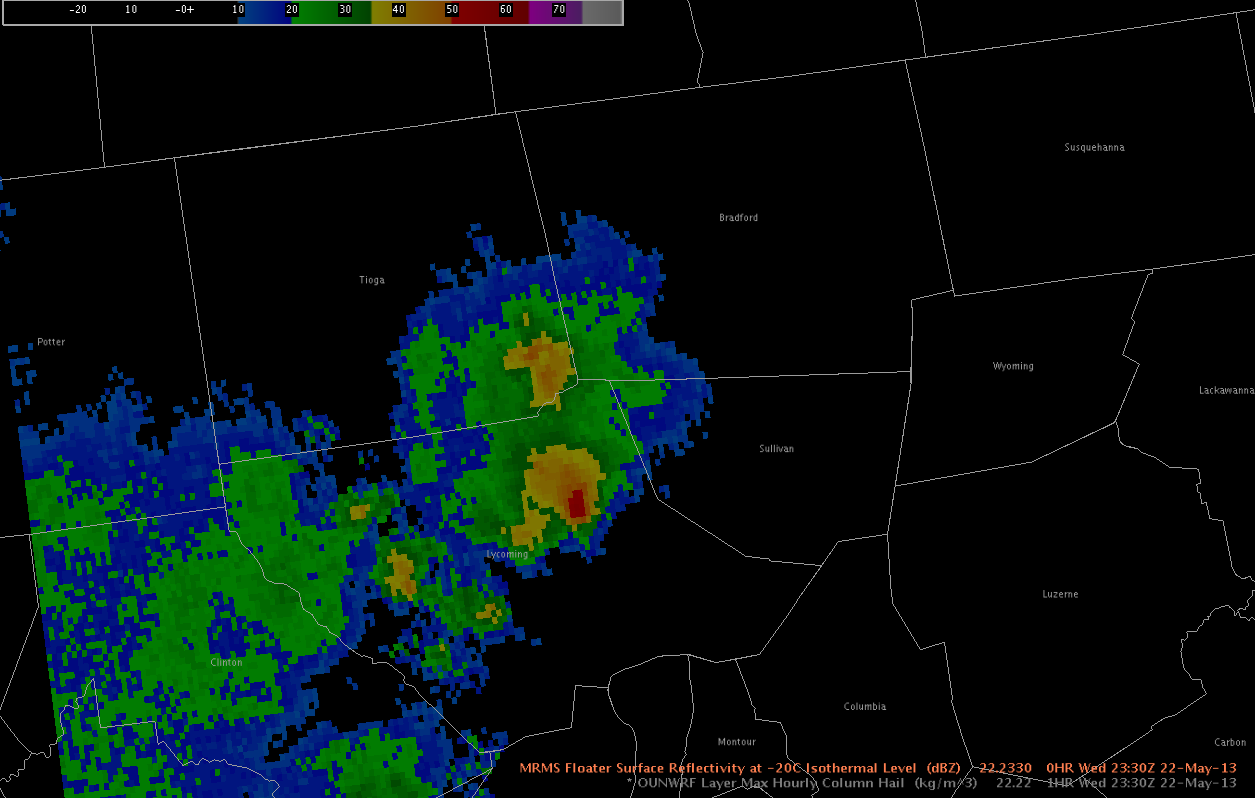
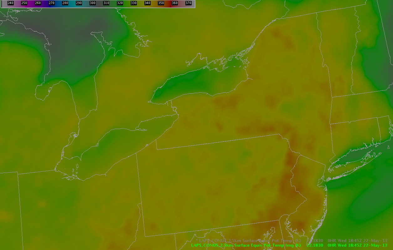
A severe threat continues in Oswego and Oneida counties… where an intense thunderstorm continues to move eastward, and golfball sized hail was recently reported in Central Square. The storm continue to move into a region of theta-E characterized by values of greater than 342 K… and lower dew point depressions near 10 K.
Farther to the south… dry air continues to dominate much of the southern portion of the BUF CWA and the southwestern portion of the BGM CWA. Convection has tried to develop throughout the cumulus field throughout the afternoon… but the substantial convection to this point has been confined to a narrow ribbon of moisture rich air just south of Lake Ontario, as previously discussed.
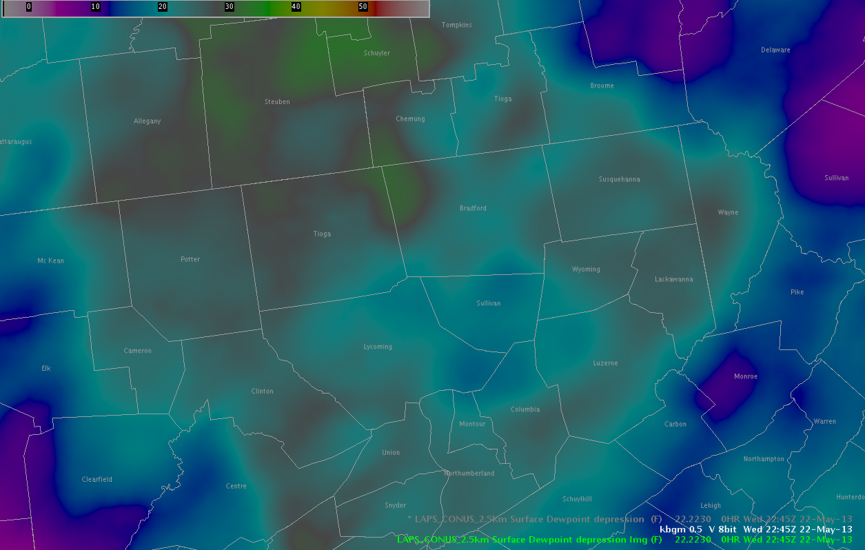
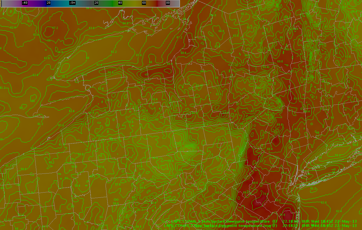
One exception is near Sullivan County PA in the southern portion of the BGM CWA… where a small region of higher moisture is indicated by the LAPS analysis. In addition to a threat of strong winds… as DCAPE values exceed 800 J/kg in a region with dew point depressions approaching 30 degrees F in some cases… a marginal severe hail threat is also evolving for the BGM area in Sullivan and Bradford Counties in the next couple of hours where LAPS is indicating higher surface dew points. Recent radar trends indicate that reflectivity above 0 C has increased in recent scans as well.
– Zimmerman/McCormick
Simulated satellite imagery from 00Z WRF runs showed strong convection near the lake in the early afternoon with clearing in western New York during the late afternoon hours. Convection only sporadically tries to develops until well after 00Z in western New York.


Convection has developed to the east-northeast of Buffalo along the moisture gradient to the north of dryer air shown on various LAPS products. The convection has struggled somewhat to maintain itself and a previous hail signature has diminished, perhaps feeling the influence of the dryer air to the south.
– McCormick

Southwesterly winds are noted to be advecting dryer air into the southern portions of western New York. Minimums of SB and ML CAPE are noted with this air mass as it moves into the area. The only healthy storm so far in western New York was located on the northern side of this air mass, and every echo closer to this air mass has struggled to develop. Convection is likely only to thrive if it develops on the moisture gradients noted in the previous mesoscale discussion and moves away from the dry air, at least until better upper level forcing arrives.
– McCormick
At the current time, one convective complex pushes to the east into New England from New York, with a stronger storm noted moving into Ulster County NY. Behind this complex, a stable layer is noted with lower Theta-E values shown on LAPS imagery.
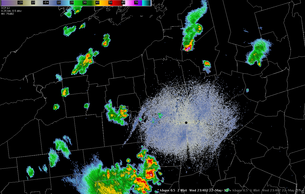
An isolated storm is also noted in northern Wayne County NY. This second storm continues to exhibit severe potential with an HSDA signature of large hail and MESH values exceeding 2 inches.
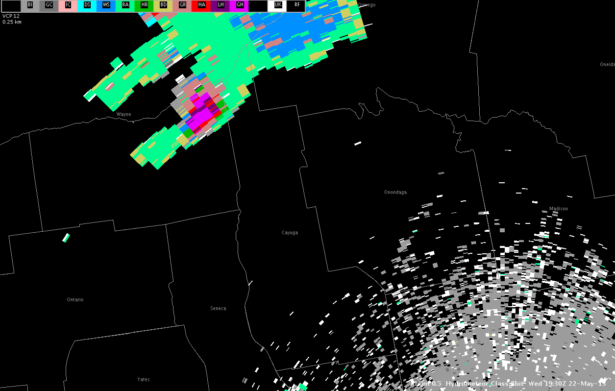
This storm is located along a convergence boundary well noted in LAPS forecast fields, with dew points in the mid to upper 60s noted south of the lakefront.
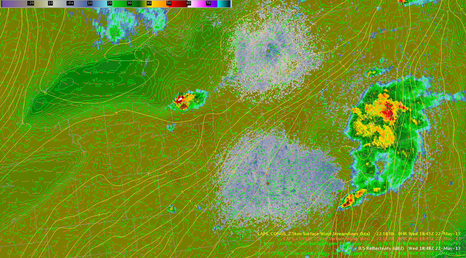
This supercell storm is expected to continue to pose a threat of severe hail and perhaps a tornado or two as it moves to the east in an environment characterized by rich moisture and unseasonably warm temperatures that have reached the low 80s, even in the presence of modest 6 km shear of 30 kts. The environment to the south is moderately unstable, characterized by RAP indicated instability values of SBCAPE approaching 2000 J/KG. In addition, a gradual increase in mid level rotation has been noted in recent scans, with storm splitting noted and both storms showing mid level rotation.
Farther to the south, in areas of weaker deep layer shear, convection is expected to increase in coverage through the afternoon hours along two particular moisture gradients noted on the LAPS dew point fields. The first boundary is located from north to south from Wayne County NY to Bradford County PA. The second boundary is located from west to east southeast from Erie County NY to Bradford County PA. Cu clouds are increasing in coverage across western NY with a few echoes beginning to appear. One of these echoes is located in Erie County NY, another two are located in Chemung and Tioga Counties. The main threat through the evening hours should be large hail… with some gusty winds in stronger storms.
– Zimmerman/McCormick