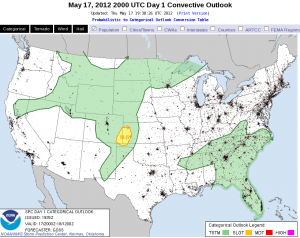
Today’s situational environment remains little changed from our expectations yesterday. An upper-level low has moved in from the Gulf yesterday to South Carolina today. Deep, moist convection (DMC) has already erupted around the perimeter of the upper low. To the south, unusually strong mid-level flow continues along the central Gulf to the FL peninsula. With plenty of moisture resident over FL, and southwesterly low-level flow, it appears we have a good juxtaposition of shear and CAPE in a climatologically unusual location. Supercells are likely, especially where the shear is strongest from St. Augustine and south. However the question of the day is expected coverage of DMC. The coolest air aloft resides close to the upper low meaning that northern FL would see the steepest lapse rates and least inhibition. Early DMC in southeast GA helps confirm this thinking. Further south, the air aloft is warmer and coverage is expected to be less. We’ll also have to rely on the initiation of the west coast seabreeze to help provide the strongest low-level forcing to overcome the greater inhibition to the south. The eastern seabreeze may help to provide enhanced low-level shear but the poor boundary-relative convective steering layer flow will limit residence time of any incipient DMC in its lifting zone. While some time may lapse before we get mature storms in the central FL peninsula, whatever storms that form could turn into supercells, especially if they latch onto the enhance shear along the eastern seabreeze. Damaging winds and large hail are possible with these storms though an unusual intersection between outflows and seabreeze interaction may enhance low-level vertical or horizontal vorticity enough for a tornado.
At this time, Todd and Stephen have localized to MLB while Brian and Julia are covering JAX.
Jim LaDue: EWP week 2 coordinator

