Ultimate CI

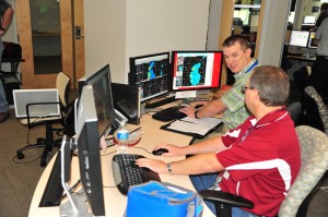
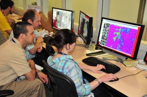
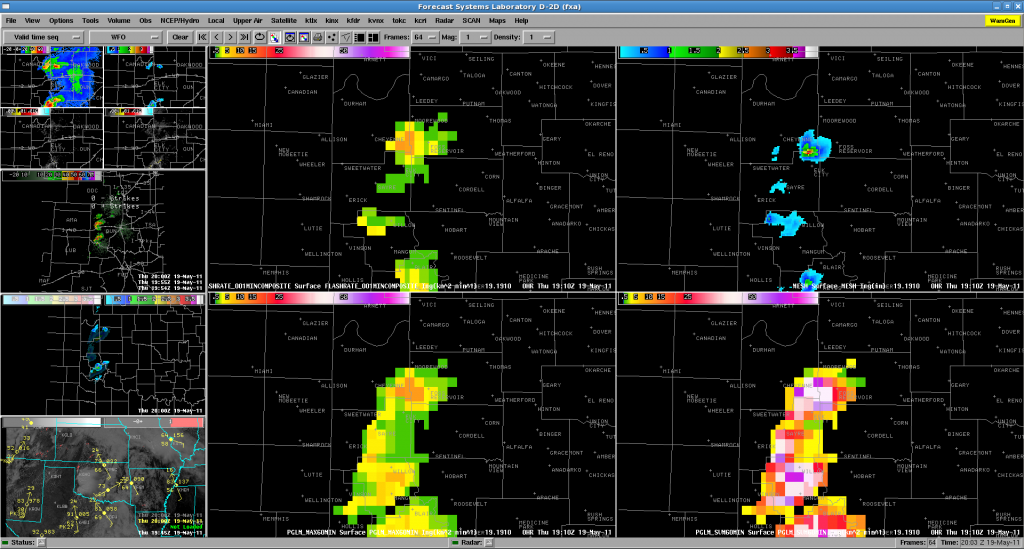
Visiting scientists and NWS forecasters visiting the EWP this week have begun looking at real-time data with the promise of some exciting weather over OK this evening. We are currently examining the SATCAST and UWCI products in combination with the multi-radar multi-sensor (MRMS) and PGLM products to anticipation convective initiation. The participants have worked together to develop what has been so lovingly called the “ultimate CI” 4-panel display within AWIPS. The 4-panel (shown above) includes the following products that are linked to the nowcast and detection of CI… Starting from top left and moving anti-cyclonic (clockwise) we have the visible with SATCAST, visible with UWCI, visible with MRMS reflectivity at -10 C, and finally visible with PGLM and NLDN lightning detections. The 4-panel has been saved as a procedure that forecasters can now load very quickly within their AWIPS D2D workstations throughout the rest of the week. Future visitors will have this available as well. This helps demonstrate the ability to combine these unique datasets from multiple sensors into one effective decision support tool.

Posted by Chris Siewert at 3:38 PM (from the GOES-R blog).

Tags: None

EWP 2011 Week #3

Week #3 is underway with our guest NWS forecasters:  Jason Jordan (WFO Lubbock, TX), Daniel Leins (WFO Phoenix, AZ), Bobby Prentice (WDTB, Norman, OK), Pablo Santos (WFO Miami, FL), and Kevin E. Smith (WFO Paducah, KY).

Morning consisted of our normal Monday training session, followed by getting used to the new products on a displaced real-time case.  As of 3:30pm, everyone has switched over to looking at real-time data, as convection is developing in western Oklahoma.

— Travis Smith, weekly coordinator

Tags: None

Week 2 Summary (May 16-20 2011)

Week two allowed us to “spread our wings” a little, in that we operated in the DC domain some, and we made use of the 19 May 2010 Displaced Real Time case.   Participants for this week were:

Kevin Brown (OUN), Kevin Donofrio (PQR), Bill Goodman (OKX), Steve Keighton (RNK), and Jessica Schultz (ROC)

We started off Monday as usual with training, however we opted to abbreviate the training and attempt to get our participants familiar with the data by having them jump into the DRT case Monday afternoon.  This appeared to have some positive affects in getting the forecasters familiar with the set up as well as getting a first look at the data.  Though I think we staved off the “death by powerpoint” issue somewhat, there still seemed to be less enthusiasm to this approach than I anticipated.

Another adjustment this week (compared to week 1) was to try and get the forecasters more involved with the EFP CI desk after getting their AFD completed for the EWP.  We tried to have the EWP forecasters inteact with the EFP CI group by considering a “second CI target”.  While this was a good idea, it is unclear quite how successfully the EWP personnel were in participating in the discussion and selection process.

On Tuesday, our AFD was initially focused on the central plains area, but shifted their guidance to the DEL-MAR-VA region.  Warning operations started off in that area on marginally severe storms.  With the remaining time, we switched to eastern CO to warn on tornadic supercells there.

Wednesday appeared to be a potentially active day for the OK domain if storms could fire.   The OUN WRF painted a really interesting scenario with a supercell very near Oklahoma City.  The DEL-MAR-VA area was again weakly severe, but we opted to use this day to monitor the CI products.  After waiting most of the day, and after a visit by NWS OS&T director Don Berchoff, we returned operations to Eastern CO again.

For Thursday’s activities, we focused again on the OK domain – and this time we had convection!  Storms fired early in SW OK.  We sectorized on these storms immediately (forgoing the EFP CI collaboration).  About a third of the way through the operations period, we shifted to the DDC/ICT/UEX domain as it appeared these storms would be more severe than the OK storms were at the time.  Before long, we switched back to the OUN storms and that’s how we finished.

The following are some highlights from the weekly wrap-up discussion:

CI

Forecasters seemed to like the non-binary CI products.  Though the UAH CI product was understood, users appreciated the level of uncertainty afforded by the CIMSS products.

UAH Sat Cast, looking for CI behind cirrus near dryline, never detected anything, which is good, no false alarms.  Positive null detection

Ice masking to aid in sanity check was useful and appreciated.

NEARCAST products seemed not much different that looking at a RUC theta-E output for a few hours, but with advantage that it is based on observations and advected where you might not have the observations later.

pGLM

There was more discussion/comments on the pGLM product throughout the week than on the last day.  Though the storms in the DEL-MAR-VA area weren’t terribly severe when we were observing them, the pGLM added some additional level of confidence in (non) severity.

The THU case was our best bet for looking at the pGLM, despite a LMA sensor/comms failure that adversely impacted the network for a period late in the operations period.

There was a request for to include what is known so far wrt to total lightning behavior.  Participants requested more WES style cases.  There was also a request for a CG/IC ratio product.

Lightning trend and jump information remains a hot topic, in that many are interested, but we want to make sure we don’t get the “cart before the horse” and verify any claims with solid research.

OUN WRF

On THU, in particular, OUN WRF gave good indication of storm morphology / mode.  Was the only modle that depicted te storms in SW OK and maintaining them.

There was a recommendation for improved/new product combination available to the forecasters.  The SimRef/Updraft Helicity/Vert. Int. Graupel is already being implemented after week 2.

Need to be wary about sharing outside the WFO (eg. EM community) for concerns of latching on to an incorrect solution.  Sometimes it “almost looks too real”.

Time ensemble output/display is desired (something that Sterling does).

3DVAR

Suggestion to break up Updraft/Downdraft composites like the vorticity layer composites (0-3,3-7, total).  Also consider Storm Relative Depth layers.

Request for a SRH product.

Placement of updraft seemed incorrect at times – especially with VA storms, but even with OK storms at times – even when compared to same-latency Sim Ref.

Think the 3DVAR products have a lot of potential to help with SA and add confidence, to help uncertainty with sampling at far ranges or over cone-of-silence.  Swaths (trends) also very helpful.

2D wind vectors would be great to have in AWIPS if possible.  Perhaps FSI, or using the “all-millibars” in the VB.

Logistics/Open Suggestions/MRMS

MRMS op system needs diagnostic tools, to show how many radars and elevation scans go into a grid point (or like CI ice-mask – not 100% optimal), and if it is less than 100% (radar outage), or radars running hot/cold.  Need diagnostic tools to determine if system is not running optimally.

Feels like, “do what you want to”, “look at everything”, “falling into comfort zone”.  Maybe the pairs of forecaster can do traditional warning, and other person looks at the experimental products.  At least one person is focused on that particular product.

We again hear the suggestion of a multi-week setup.  We are certainly not opposed to this, though NWS logistics would be a tough hurdle to overcome.

Hearing greater support (as well as from Week 3) for requiring future participants to complete training prior to arriving.  (powerpoints, articulate, WES cases).  This would help us gain “Monday” as an operational day.

Respectfully Submitted:

-kevin manross :: 2011 EWP Week 2 Weekly Coordinator

Tags: None

Forecaster Thoughts – Kevin Donofrio (2011 Week 2)

I share some of Steve Keighton’s comments on structure/logistics of the EWP. Here are a few more general comments: I think collaboration with the EFP could be very useful, I just did not find it to be the one day that I was not on the full-blown warning shift. I also would find it useful to either a) Not be completely focused on the timeliness of warnings, and more on the analysis of the products, (b) Possibly having certain forecasters focus on certain products at various times in the warning process. That said, it is good to see what products came to the forefront and which ones maybe were not (and maybe should have!), and to truly mimic a warning environment,. Having grown accustomed to 3 D2D screens in a warning environment, I did not use quite as many products as I would have in a typical environment, and was also creating procedures on the fly, which I would not normally do in a warning situation. I would be really interested to see the effects of Dual Polarization has on screen real estate, and if it would affect the experimental products chosen for use in the warming decision/awareness process. I think we all tried to strike a balance between attempting to simulate and get warnings out in “real” time vs. giving each new tool more attention.

Below are a few key points about specific products from my experience. These comments have been shared with the staff at WFO Portland, and will be shared with all Western Region SOOs.

* The OUN WRF was a “hot model”, in that it also appeared to break the cap too quickly. That said, it did clue us in to potential scenarios, and seemed to have a decent grasp on convective mode expected, given convective initiation. It would be nice to have this run in an ensemble mode as well, as it basically served as another tool to compare to EMC WRF, NSSL WRF, and the RUC HRRR models.

* The 3DVAR Multi-Radar Real Time Data Assimilation Products, while fairly new, hold alot of promise. The products that I found useful included the Updraft (instantaneous and track) and the Rotation products. The Updraft product, while sometimes misplaced, was still very valuable. The downdraft products were a bit noisy, not only in multicell situations, but even in supercell cases. These products aided in assessing whether updrafts were strengthening or weakening, and the rotation track also aided in more accurately following storm motion. While I did not rely on these products, and did always confirm what I was seeing with my traditional radar analysis, it did provide a clearer situational awareness picture, and it was fairly easy to create procedures to integrate into the warning decision process.

* Convective Initiation tools, while useful, are still contaminated by cirrus. They did provide some lead time before seeing significant radar echoes, though lead time in rapidly developing cases was not much more. I did find, once radar operations got more intense, that I did ignore these products a bit more than I wanted to, but it was more a workload issue. Also, on the days where convective initiation did not occur, these tools provided a correct NULL result. I did like the CIMSS product a bit better, as it provided CI likely, CI occurring, CI possible vs. a YES/NO from UAH. The UAH algorithm was too sensitive, and the CIMSS product seemed not sensitive enough. This is intended as the CIMSS product is going for a low False Alarm Rate, and UAH is going for high Probability of Detection.

* We got to look at multi-cellular and more borderline cases as well, which was very useful instead of focusing on “supercell” cases. The products didn’t do too bad, though seemed to perform best in more traditional supercellular cases.

* The pseudo-GLM was very useful in that it focused attention on storm intensification, and was able to pick up on flash rates much earlier than the CG network. Though I did not see this for many borderline cases, this would be useful when the forecaster is not sure whether particular areas are electrified or not, particularly when not seeing any CG strikes.

* I relied heavily on the Multi-radar, multi-sensor products when in a warning environment. I wouldn’t say they made the warning decision for me, but they served as a great situational awareness tool as to where to focus my attention. Of particular use were the -10C and -20 C Reflectivity products, but my favorites were the 50 dbz height above/below a user specified level (such as the -20 C level), MESH (Multi-radar estimated hail size, both instantaneous and track). These products were great for estimating hail size when combined with radar tools. These products are available (they are adding the Western domain soon, if not already) on wdssii.nssl.noaa.gov as KML files, or on a neat google map in
development wdssii.nssl.noaa.gov/maps.

Thank you again for allowing me to participate in the EWP this year. This was my first experience in an experimental warning program, and I hope to leverage this experience to spread the word on the promise on new warning decision tools, and to hopefully participate in another Experimental Warning Program in the future.

Kevin Donofrio (General Forecaster, NWS Portland OR – EWP2011 Week 2 Participant)

Tags: None

Forecaster Thoughts – Steve Keighton (2011 Week 2)

* Overall, another very valuable experience for me, and an important program to get feedback from forecasters during the development process. Thanks for the opportunity!

* A general suggestion is to either require participants to review materials on the products ahead of time (through recorded presentations), and then have a much shorter period the first day for SMEs to summarize and answer questions, thus allowing more time on the first day to get more familiar with products and procedures during a WES….OR, more ideally, have participants come for a two week period to get especially comfortable with the background on the products, and more time spent really working with the various products, and perhaps more opportunity for concentrated time spend really evaluating one product at a time initially. I realize though this would reduce the number of overall participants, and that’s not good either.  So just something to consider perhaps. I felt that there just wasn’t quite enough time to really get to know and work with each of the products, and we were just getting there on the last day.  A more focused effort on each product before given the flexibility to use any or all to help make warning decisions or raise S.A. would be better, since I felt I was trying to make sure I frequently tried to look at all of them, while at the same time trying to keep up with warning decisions using traditional products/methods too.

* Another general suggestion is to consider different interactions with the EFP side than what we did.  Felt it was generally a waste of time to work with the CI group that one day I did that, and would prefer to work with the severe wx desk and get a sense for the various models and high res ensembles they were evaluating. We got to evaluate the OUN WRF, but that’s just one potential solution.

* I was most impressed with the promise of the 3DVAR products in terms of a little more of a complete picture of storm structure/intensity (4D really with tracks of max updraft and rotation very helpful for trends to stand out).  These were particularly helpful in combo with traditional radar products, especially with 5 minute updates, but latency is the one concern. Not likely to make a warning decision based solely on these, but certainly adds confidence to decisions being considered with traditional (usually base radar) products.  Obviously with the future potential to advect this in the future from RUC-based forecasts will add another dimension to it’s utility.  Specific comments on the various products available were made via the survey forms, but here will just mention the need to improve the downdraft product (focus on lower levels), perhaps updraft too (various levels), an updraft helicity product, and then access in AWIPS to the 2D winds would be a great benefit.

* I was a little discouraged with the CI products, but do see the potential, but would like to have spent more time with these in different environments. My impression is that these will be most helpful for otherwise clear conditions with CI expected on a boundary like the dry-line, and much less useful in moist “airmass” type environments, and obviously when there is cirrus or present (these last two scenarios are fairly common here in the mid-Atlantic region). A little concerned about two different efforts/groups developing different CI products, and each seemed to have some advantages, in my limited experience that one one week I was more impressed with the UAH version, (with more detections), but need the multi-tier output I think like the UW-CIMSS version.

* OUN WRF (as other high res convective resolving models have shown) certainly has a lot to offer in terms of helping to anticipate storm mode and to some degree evolution, but not necessarily the locations or timing (timing probably worst).  Still need to have a collection or ensemble of these to get a better feel for the ranges of timing and locations, but looking at the details of a single model and it’s trends can still provide some helpful info for overall S.A., and ultimately leads to quicker decisions if you are ready to anticipate certain structures/evolutions. Despite some errors in timing and placement on that last active day we were there (May 19), the signals were good enough to help prepare for some upscale evolutions during the evening, and did suggest some early convection initiation (which some other models did not have).

* Finally, love the new wdsii-nssl map web page for the MRMS products (even though we weren’t specifically evaluating those). I used these frequently in AWIPS, with some of the same advantages of the 3DVAR products such as trends, but the rapid update for these since they are multi-radar is a uniqe advantage.  I’m more easily to introduce these products to my staff using the web page (http://wdsii.nssl.noaa.gov/maps), but would also like to work with ER SSD to get these into AWIPS via LDM (when I get a chance!).

* I just realized I totally left out any comments on the PGLM data!!  IN part I think since I really did not get a chance to spend much time evaluating it. In one case, one of the key ground sensors actually dropped out and it gave the impression that the flash density dropped when it really didn’t. Also, for this event the NLDN CG data was intermittent so not a good chance to compare the two.  Again, I think with this data set it would be especially important to focus solely on this product for most of an afternoon/evening, or during a DRT case.  Still don’t have a real good feel for how the total lightning relates to the CG data we are used to tracking, and relationship to severe weather.  I think it would be very important to almost spend at least one day on this one product to get some worthwhile feedback. Sorry I don’t have more on this.

Steve Keighton (Science and Operations Officer, NWS Blacksburg VA – EWP2011 Week 2 Participant)

Tags: None

Update 19 May 2011: 2208 UTC

We’ve re-localized to the Dodge City, Wichita and Hastings CWA’s for the remainder of the shift.  Focus will remain on the 3DVAR data and products with the severe and tornadic storms across the region.

Kevin D. and Bill are taking over the Hastings CWA while K. Brown is monitoring DDC and Steve is focusing on the ICT domain.

The startup of this switch has been slightly delayed due to technical problems with the ingest of experimental products.  Expecting things going to be up and going in the next ten minutes.  Multiple tornadic storms are already ongoing across the region.

Tags: None

Week 2 :: Day 4

A good day for warning operations.  Storms began initiating prior to the 1 pm discussion just south of Childress, TX.  We jumped into warning operations immediately after our portion of the discussion.

At first, we had everyone issuing their own warnings at each workstation (minus the PAR corner which is being used to collect data).  Unfortunately since we are all in the same CWA, everyone was seeing each others’ warnings.  We then sectorized and had K Brown and Steve focusing on storms at I40 and North,

with Jessica, Bill and Kevin D focusing on the cells south of I40:

We will continue operations in OUN’s CWA, with an eye on Central KS for additional development of supercellular thunderstorms.  If those develop, we will consider having a pair of forecasters move to that area.

-K Manross :: Week2 EWP Weekly Coordinator.

Tags: None

pGLM realtime comparison with MESH and 3D-Var Updraft

With warning operations already underway for western Oklahoma, forecasters are deep into their storm analysis.

One of the more interesting features they have been picking up on is the consistent signals between the pGLM lightning trends and values from the MESH algorithm as well as the 3D-Var derived updraft fields.

This was well illustrated by the storm north of Elk City moving from Beckham to Roger Mills county.   At approximately the same time ~1900-1915 UTC, the lightning rate increased from 5 to 15 flashes per min (per pGLM grid box, not per storm) as MESH ramped up and updraft increased within the 3D-Var product. Shortly after this increase, both the pGLM and MESH values decreased with this storm (the 3D-Var updraft values also showed this, but with a bit of a time lag).

pGLM flash density and MESH values at 1910 UTC on 19 May 2011

Also of note, prior to losing NLDN data, with the storms seemed to be producing relatively little CG lightning.  In this case, the pGLM data was definitely giving a better view of the electrical activity and storm intensity. (1 to 1.75 in hail has already been reported across West and SW Oklahoma).

-K. Kuhlman (pGLM scientist, week 2)

Tags: None

19 May 2011 morning discussion

Area of focus will be KS/OK, where dryline convection is forecast by all high-res models. There are timing differences between SPC WRF, HRRR, and OUN WRF…with OUN WRF and HRRR convecting earlier. Late morning OA indicating that cap has weakened to under 25 j/kg along and east of dryline so initiation before 20z possible near and south of Red River. Later initiation expected farther north across west-central and northwest OK, and with diurnal backing and low-level jet intensifcation, early this evening, intensification and tornado potential will increase by 23/00z.

Primary area of concern will be northwest Oklahoma into south-central Kansas (OUN-ICT CWAs) where tornadic potential will be higher and overall coverage expected to be greater. Although instability will be substantial farther south, better shear/LCL values will be seen farther north across nw OK into srn KS. This idea, with much greater updraft helicity forecasts, is supported by OUN WRF. Any convection in SW OK/NW TX is fcst to occur fairly early with weak cap…but not develop particularly strong or rotating updrafts. Concern that if a large area fires too early that may limit additional convectiv e development over nw OK or s-central KS due to cirrus debris.  Still…low-level jet strengthening by evening may be enough to help support stronger convection in KS.

18Z position of dryline is just east of DDC to GAG/CDS/SNK. Little in the way of eastward mixing is expected today given deeper moisture to its east and strong jet/ht falls to its west. If storms can get going over west-central and northwest Oklahoma, they should have a better chance of survival off/east of dryline with much better flow over that region.

Despite some degree of uncertainty in timing and exact locations for supercell development in the srn Plains today…high res model guidance and lack of jet cirrus are giving us more confidence that deep convection will in fact develop in a few spots along dryline compared to yesterday…and thus it makes sense to stay focused on the OUN/DDC/ICT CWAs throughout the day…rather than spending any time at all evaluating products in the mid-Atlantic, where shallow convection under persistent upper low is expected to fire again with diurnal heating.  In fact some very shallow convection already occuring and overall severe threat looks very minimal there.

Tags: None