An official website of the United States government
Here’s how you know
Official websites use .gov A
.gov website belongs to an official government
organization in the United States.
Secure .gov websites use HTTPS A
lock (
) or https:// means you’ve safely connected to
the .gov website. Share sensitive information only on official,
secure websites.
After I blogged earlier myself, along with others earlier about the more stable airmass near the southern Lake Ontario shoreline, I went ahead and issued a severe for NORTHERN CAYUGA COUNTY IN CENTRAL NEW YORK…SOUTHWESTERN OSWEGO COUNTY IN CENTRAL NEW YORK… NORTHEASTERN WAYNE COUNTY IN WESTERN NEW YORK…despite the fact I knew earlier this activity wasn’t severe (and also per real-time reports). A no-no on my part, but just to prove my point, this is the MESH product at the time I issued that severe thunderstorm warning. Lesson learned (Eric).
Simulated satellite imagery from 00Z WRF runs showed strong convection near the lake in the early afternoon with clearing in western New York during the late afternoon hours. Convection only sporadically tries to develops until well after 00Z in western New York.
Hail has been below severe limits in the Monroe and Wayne counties in upstate NY. As noted on an earlier blog, less stable air has slowly advected south across parts of these counties from Lake Ontario. Below will is the 2102 UTC reflectivity image and corresponding MESH image from KBUF radar. This is when storms were at their most intense with only half inch hail being reported out of the southwest Wayne Co storm. Another strong storms was developing across central Monroe Co at the time.
Here’s the 2120 UTC radar reflectivity from KBUF and corresponding MESH. The Wayne Co storm has maintained or slightly weakend as it moves towards the more stable airmass off Lake Ontario. Meanwhile, the Monroe storm has weakened considerably and was closer to the lakeshore. This is basically 18 minutes later from the first capture.
Okay, here’s another golf ball size hail report, this time from a little bit later in far northern Cayuga County, NY. First, before I go further, I have to say I like the name of this county…as it sounds like an old car horn. Anyway, from 2000-2010 a member of the public reported golf ball size hail near the town of Cato. Here’s an image from the middle of that period (2004 UTC), using the MRMS and KTYX HSDA data.
Image 1. MRMS and KTYX data valid 2004 UTC. Upper left – MRMS Merged reflectivity QC composite, upper right – MRMS reflectivity at -20C, lower right – MRMS MESH, lower left – KTYX hybrid hydrometeor class
Notice again the absence of large or giant hail in the HSDA data from KTYX (the closest radar). I’m thinking I may have to look at higher slices from the KTYX dual-pol and start analyzing those slices of the HC data. Of interest, notice also the TBSS appearing in the MRMS reflectivity and the KTYX HSDA data.
Storm number 1 as seen in image 1 had a nice long rotating track that had modest rotation at times. This was a good distance from the radar so even at the lowest slice was rather elevated. Felt the rotation was weak enough and elevated enough to just keep it a svr thunderstorm warning. Reflectivity also did not look overly impressive. We did get several severe hail reports.
Storm number 2 as seen below also had a persistent rotating updraft, but rotation was not as strong as in storm number 1 above. This storm did produce golf ball size hail, but the rotation was not significant enough to warrant a tornado warning. Thus we went with severe thunderstorm warnings. WeselyWesely
Convection has developed to the east-northeast of Buffalo along the moisture gradient to the north of dryer air shown on various LAPS products. The convection has struggled somewhat to maintain itself and a previous hail signature has diminished, perhaps feeling the influence of the dryer air to the south.
The image below shows the following: Height of 50 dBZ above -20C upper left, height of 50 dBZ above 0C lower left, height of 60 dBZ above -20C upper right, and height of 60 dBZ above 0C lower right. This image was taken at 2028 UTC 8min prior to the report (note the height of these cores lowered by the time of the report). At this time the height of the -50 dBZ above -20C was ~13k ft.
Okay, we just got a delayed hail report from Wayne County…golf ball size hail at 1936 UTC! So, what did some of the same data show at this time? Here’s a look…
This first image is a four panel of the MRMS data, containing the KBUF HSDA (lower left). At this time, the MRMS reflectivity values at -20 C were 65 dBZ. MESH values were as high as 1.65 inches (2 minutes previous it showed 1.73 inces). However, the HSDA still indicates sub-severe hail.
Image 1. MRMS data valid at 1936 UTC and KBUF radar data valid at 1937 UTC. Upper left – MRMS merged reflectivity QC composite, upper right – reflectivity at -20C isothermal level, lower right – MRMS MESH, lower left – KBUF Hybrid Hydrometeor Class
The next image contains the MRMS and KYTX radar data at about the same time. Notice here again, the sub-severe classification of the hydrometeors.
Image 2. MRMS data and KYTX radar data valid at 1936 UTC. Upper left – MRMS merged reflectivity QC composite, upper right – reflectivity at -20C isothermal level, lower right – MRMS MESH, lower left – KBUF Hybrid Hydrometeor Class
Also worth mentioning is the 2-minute temporal resolution of the MRMS data, which can be advantageous in warning situations and could potentially keep forecasters from switching back-and-forth from radar to radar and saving time from looking at all-tilts so much…as is my primary current warning strategy.
Southwesterly winds are noted to be advecting dryer air into the southern portions of western New York. Minimums of SB and ML CAPE are noted with this air mass as it moves into the area. The only healthy storm so far in western New York was located on the northern side of this air mass, and every echo closer to this air mass has struggled to develop. Convection is likely only to thrive if it develops on the moisture gradients noted in the previous mesoscale discussion and moves away from the dry air, at least until better upper level forcing arrives.
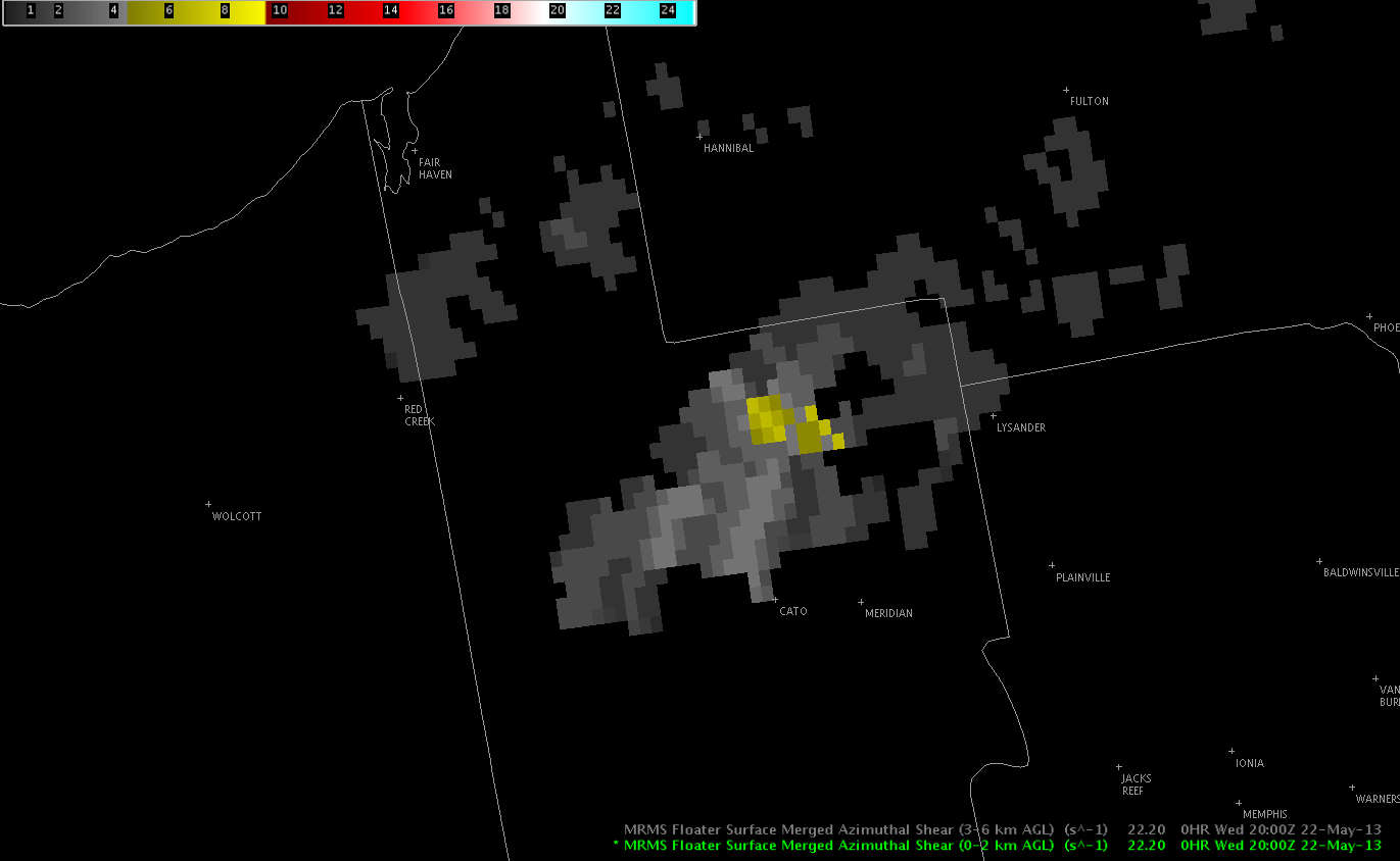
Based on the SRM radar data combined with a few MRMS products, Eric decided to issue a tor warning for the strengthening cell in Cayuga County at approx 1959 UTC. Whether or not this storm has produced or will produce a tornado remains to be seen. Nevertheless, here are some of the imagery which helped with the warning decision process…
Figure 1. KTYX SRM imagery valid at 2000 UTC indicating the broad rotation in this cell aloft.
The next image is the MRMS 0-2 km azimuthal shear product valid at approx 2000 UTC. Notice the higher values in NE portions of Cayuga County coincident with the broad rotation noted on the KYTX radar.
Image 2. MRMS 0-2 km azimuthal shear valid 2000 UTC.
Lastly, here is the MRMS low level 30 minute rotation tracks data valid at 1957 UTC.
Image 3. MRMS 30 minute rotation tracks valid at 1957 UTC.
Granted, there is still some product familiarity and pattern recognition needed with these newer types of data.