Live Blog – 2 June 2008 (7:06pm)

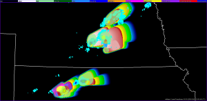
Shave is operating on our storms. Golfball hail in eastern most storm. This storm is undergoing some mergers (area is getting larger) and turning a little to the right so threat area is updated based on this.

Jon suggests that tracking feature translate (as in WarnGen) to better help forecasters see if they’ve located the same feature in previous frames.

Liz Quoetone (EWP Weekly Coordinator, 2-6 June)

Tags: None

Live Blog – 29 May 2008 (7:50pm)

Making a note of this for the ROC, lookin gat velocity data quality issues: Patrick noted some velocity delaliasing failures on KUEX at a crucial decision-making point about 30 minutes ago. He stated that this happened several times on KFDX data yesterday (last night) as well.

Travis Smith (Gridded Warning Cognizant Scientist)

Tags: None

Live Blog – 29 May 2008 (7:14pm)

Team 1 is facing the problem of having their warnings expire… would be good to either give notification 15 min before this happens (such as a pop up window) or a feature on the screen that could be given in the readout telling the forecaster how much longer the warning lasts. They are rapidly trying to update all their warnings as storms continue to merge, are going to switch to tornado threat only for two storms.

Team 2 is now monitoring one main storm in NE. Multiple cells have merged and they are letting the other threats expire as they move out of the area. For the remaining period they will focus on the tornado and hail threats for the Aurora, NE storm.

Will continue operations until 0030 UTC then begin discussion of the evenings activities.

-K. Kuhlman

Tags: None

Live Blog – 29 May 2008 (6:36pm)

Team 2 continues to work the multiple threats in NE and Team 1 in KS as seen by the probabilistic swaths and threat areas shown above.

3 storms may be a bit too much for one person to handle. Team 1 had their tornado probabilities for the first storm disappear for a time period, they may not have waited the necessary 10-15 seconds before issuing the next threat. They currently have a third smaller prob tornado threat for Logan that doesn’t seem to be updating though it has been saved–ahhh, problem is that the auto-update was turned off and it had saved the warning at a previous time in the past. The multiple polygons located at the original warning location on the screen continues to add to confusion, would be best to have these translate in time with the set storm motion.

Team 2 seems to be working better after changing the naming philosophy-named storms in terms of location relative to each other (e.g., lead storm), within own CWA would probably use county or city names. Looping control in the lower right panel would also add to the ease of use within WDSSII.

Kristin Kuhlman (Gridded Warning Cognizant Scientist)

Tags: None

Live Blog – 29 May 2008 (6:23pm)

Kevin has taken over warning operations for team 2. They currently have 4 tornado, 1 wind, 5 hail threats they are monitoring… this may be a bit too much. Kevin has chosen to let far western hail threat expire to help with workload and the cell has moved out of the area. Again it is hard to maintain which threat area belongs with which storm, Kevin will be renaming the polygons as he updates them. Strong inflow continues for these storms and new cell development is beginning near the radar.

Eric is now in control of the threats for team 1. They are monitoring 3 storms with 3 threats (hail, wind and tornado) on each. Funnel clouds and nickel to golf ball size hail continue to be reported with a couple of their storms.

Kristin Kuhlman (Gridded Warning Cognizant Scientist)

Tags: None

Live Blog – 29 May 2008 (5:58pm)

Each team is now monitoring at least 8 threats each, multiple tornadoes have been reported in both locations (NE and KS) and shown on live chaser cams. (So much is going on I’m having problems keeping up with the activities of both teams at this point.)

Dinner activities are beginning and the forecasters plan on switching jobs for the remainder of the evening.

With the storms tracking over each other, the probwarn swaths have overlapped. Patrick notes that some locations may have a high prob now and then a lower prob again later… gives knowledge that multiple storms will be affecting the area.

Team 2 is monitoring 3 separate tornado areas (two on one storm)–all with reported tornadoes, one currently visible on chaser cam.

Team 1 had a wind warning that was much larger than they had originally intended, updated to change size, about 2 min of larger size than intended.

Kristin Kuhlman (Gridded Warning Cognizant Scientist)

Tags: None

Live Blog – 29 May 2008 (5:29pm)

Both teams continue to monitor multiple threats (hail and tornado) on multiple storms in northern KS and central NE. Team 1 has transferred a storm to Team 2 as it moves northward out of KS and into NE. Team 2 is monitoring 5 different threat polygons. They are dealing with multiple splits and mergers as storms are catching up with the supercell furtherest east. One of the hail threats just expired and they are having problems choosing which polygon goes which storm… updating every 15 min might prevent this problem to some degree. They currently have about 3 different hail polygons sitting almost on top each other and it is causing quite a few problems in covering the multiple storms. Have decided to just issue a completely new warning, another suggestion would be to label warning output (current threat areas) with name of polygon on screen; this exercise has become a bit of a nightmare in circle management. Storm chasers are reporting power flashes and damage in Kearney, NE for one of the storms Team 2 is working.

Funnel noted on live chaser cam on KS storm Team 1 is working on. They had just previously bumped up the tornado probabilities over 80% for this storm . The county naming convention seems to be working well for this team, although there is debate on whether the name should be changed as the storms move into new counties. After handing off the northern storm to Team 2, Team 1 is now working 2 storms though they beginning analysis on third storm on Gove Co. There are other storms in the general area, however they are leaving these to ‘ghost forecasters’ to handle. They currently are managing 7 different threat areas on the three storms.

Kristin Kuhlman (Gridded Warning Cognizant Scientist)

Tags: None