ProbSvr gives good lead time

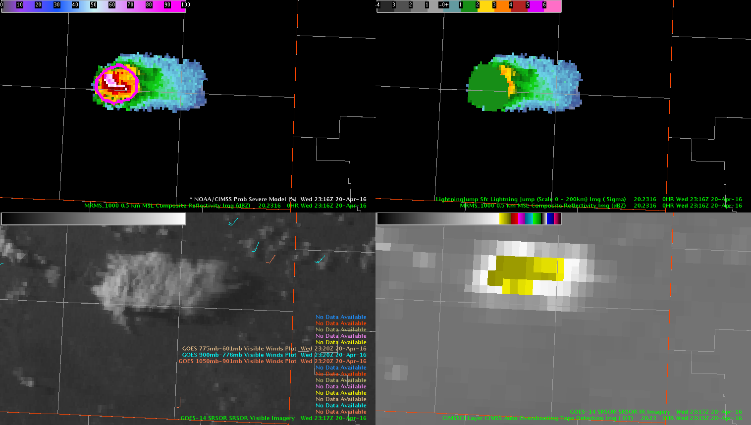
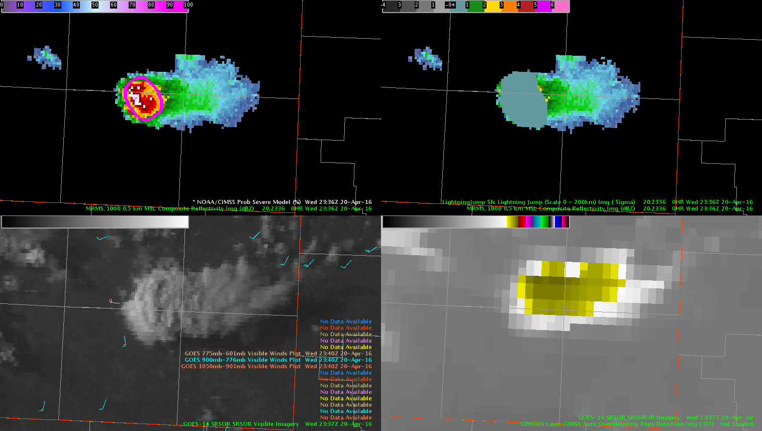
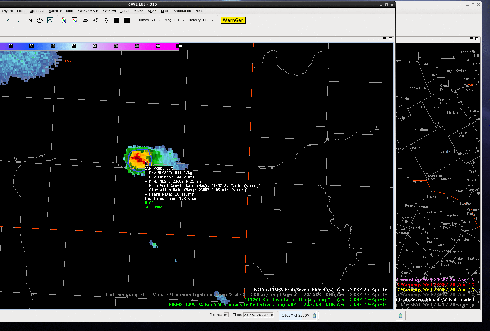
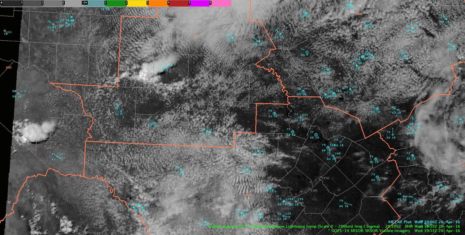
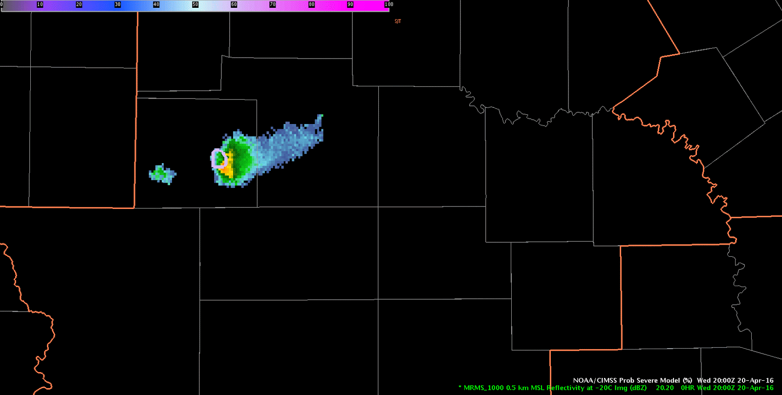
Looking at the use of prob severe in providing lead time. At 23:36z a report of ping pong ball size hail.

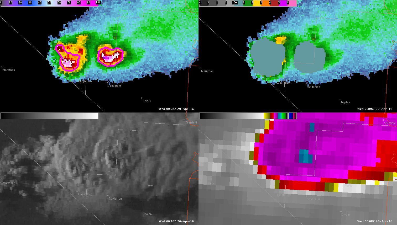
Analysis of prob severe and lightning jump 20 minutes before at 23:16z , shows the probSvr displaying 91% chance of severe, 46kts shear, MU cape 947, Mesh 1.07″, Growth rate strong: glaciation: strong, flash rate 28/min and 1 signa jump.

20 minutes later at 23:36z:  90% chance of severe, 49 kts shear, Mu cape 1157, Mesh 1.93″, Growth rate:strong, Glaciation: strong, 0 signa. ( however, jump did stay at 1 during 20 min duration.)

One report of ping pong ball size hail at that point.

Prob severe may be a good factor in issuing an early warning for a severe storm.

-thunder

ProbSVR20minout

ProgSvrPingPongHail

Tags: None

Eastern Amarillo CWA Storm

While we are watching storms in the Lubbock CWA, I kept an eye on a storm over the eastern portion of Amarillo CWA, near I-40.  The ProbSevere was 25% at 2308 UTC and jumped to 84% by 2314 UTC as MRMS MESH and total lightning flash rates jumped significantly (also the effective bulk shear was rather high in the mid/upper 40 knots).  The ProbSevere values continued to increase into the 90% range.  A 1.00″ hail report was received at Interstate 40 at 2325 UTC and after the report was received, a severe thunderstorm warning issued.  The good lead-time for this storm can be attributed to all predictors of ProbSevere–strong satellite growth rates, strong satellite growth rates, increasing lightning in a highly sheared environment and MRMS MESH over 1.00″.

NOAA/CIMSS ProbSevere contours and MRMS composite reflectivity valid 2308 - 2332 UTC 20 April 2016.
NOAA/CIMSS ProbSevere contours and MRMS composite reflectivity valid 2308 – 2332 UTC 20 April 2016. (click for animation)

-Sieglaff

Tags: None

Storm Southeast of LBB’s RDA

Storm development has occurred southeast of the Lubbock, TX RDA in the Texas Panhandle.  While initially the all-tilts reflectivity looked promising, PROBSvr continued to indicate marginal severe potential.  Combine this with no significant lightning jump and low flash density on the PGLM array, the decision was made to hold off on a warning for now.LBBRadar


Tags: None

First Warning in San Angelo CWA

A thunderstorm developed along a residual outflow boundary/stationary front southwest of San Angelo Wednesday afternoon.  The forecaster group issued an experimental severe thunderstorm warning based on lightning jump data, ProbSevere output, and all radar tilts examination.  Figure 1 below shows a loop of 0.5 degree KSJT reflectivity and ProbSevere contours.  ProbSevere first exceeded 50% at 1952 UTC, 60% at 2002 UTC, and 80% at 2012 UTC.  The experimental data along with all radar tilts analysis helped forecasters increase lead-time and confidence in issuing a severe thunderstorm warning.  After the warning was issued the storm again experienced a lightning jump and ProbSevere values maxed at 100%, with MRMS MESH over 3.00″.

KSJT 0.5 degree reflectivity, NOAA/CIMSS ProbSevere contours and experimental severe thunderstorm warning polygons valid 1948 - 2016 UTC 20 April 2016.
KSJT 0.5 degree reflectivity, NOAA/CIMSS ProbSevere contours and experimental severe thunderstorm warning polygons valid 1948 – 2016 UTC 20 April 2016.

-Sieglaff

Tags: None

Mesoscale Analysis as of 1830z

J-Money Mesoscale Analysis as of 1830z:

Two regional short-wave features to note in the 700-500 mb layer this afternoon, as per water vapor imagery and meso-analysis data.  The leading system was near the TX/LA border and pushing east, with associated storms being heavy rain producers, given saturated, weakly sheared environment.  Houston LMA and flash rate density products show a fair amount of lightning as well.

Through 19-22z, better convective potential may shift to central/south TX, as a subtle 700 mb short-wave over west TX moves in.  This may interact with a decelerating outflow boundary in the vicinity.  Layered PW data depicts the leading edge of mid-level dry air and presumably steeper lapse rates as well.  Main question is can strong 700 mb cap shown on 12z KDRT sounding be overcome.  Time will tell.   Maybe 19z NUCAPS could help later today?

LayeredPW_CentralTX

1-minutevis_lightning


Tags: None

LJA and Severe CI

Thunderstorms finally beginning to develop across Pecos County in west Texas as midlevel shortwave trough continues to slowly apprach the area.  Recent development has seen a 8 sigma jump in lightning activity across south-central Pecos County.

Lightning Jump scale 0, from 2124 to 2136.  5 min NLDN CG flashes also plotted.
Lightning Jump scale 0, from 2124 to 2136. 5 min NLDN CG flashes also plotted.

Severe CI actually peaked at 64% for this storm…

UAH Severe CI algorithm for same storm.
Tags: None