

Additional convective development continues late this afternoon mainly along the sharp CAPE gradient in southwest Texas.
Category: General
General Information and News
ENI LJDA Sigma Values Not Matching Time Trend Flash Data
The ENI time trend flash data for a storm in sern NM did not seem to indicate the 7 sigma jump in strikes seen in the LJDA. The LJDA had a 7 sigma jump indicated at 2235Z, however the time trend trace does not seem to warrant that value.


Lightning Jump with Pulsing Storms
The Lightning Jump Detection Algorithm showed sigma values of 2 to 5 with some storms in the Western Portion of Norman’s CWA. Immediately after each jump there was a corresponding downward spike in lightning as seen in the Earth Networks time series below. This shows the pulsing nature of these storms.
The lightning detection color codes are helpful, but it would be nice to overlay these on radar to easily match up with cells. Perhaps make the shading translucent.

Pickles 5/18/2015 22z
The modified NUCAPS sounding showed very good correlation with latest RAP output. (Fig 1) The lowest level of the sounding was modified based on nearest obs from KMRF and KE38 to generate around 2700 J/KG of MUCAPE. (Fig 2) This correlated well with the latest RAP data. (Fig 3)
Fig1

Fig 2

Fig 3.

NUCAPS
A VIIRS Satellite Pass at 1944Z provided a NUCAPS Profile near some developing storms in Texas. It provided a nice snapshot of the atmosphere in between soundings. The surface temp and dewpoint were modified in the sounding below based on nearby obs. When evaluating these storms with the Prob Severe Model it showed MUCAPE values of around 3800 J/KG. Meanwhile the GOES R Sounder product indicated layer CAPE of around 2700 J/KG in this area. The NUCAP reinforced the higher values. It seems like it would be useful in identifying areas to watch for convective development or monitoring modification of the atmosphere (like a dissipating cap).
Although the lat/lon is shown in the NUCAPS sounding, it would also be useful to have the point plotted on a map within the sounding. For quicker review of nearby soundings it would be nice to just mouse from point to p

A Win For NUCAPS
The NUCAPS sounder represented the environment across Oklahoma this afternoon really well compared to the nearby surface observations. Below is a sounding from a mostly sunny region near some developing convection.

The near surface environment shows a temperature of 76 to 77 degrees and dewpoint of 67. The closest surface observation had a temperature of 80 with a dewpoint of 65. Pretty good.
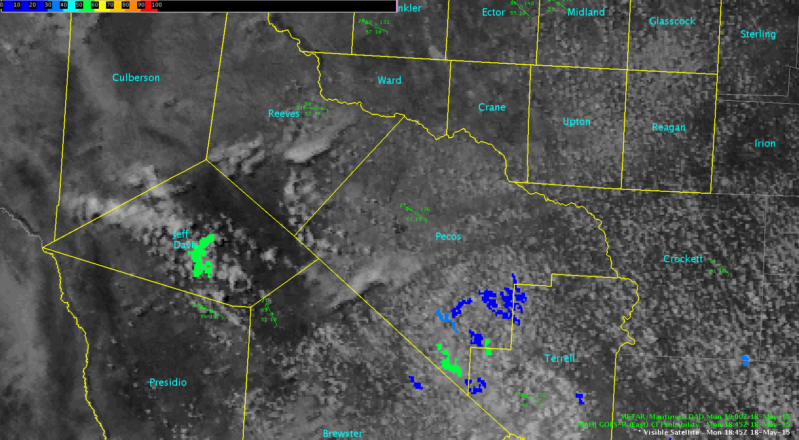
CI Signal Consistency Hits Initiation
When monitoring boundary layer cumulus, some sporadic CI pixels over 50% would occasionally be seen. However, an area was seen to slowly increase in probability with each CI/Vis product evaluated over 60 minutes in southern Reeves county. A great contrast can be seen with CI data over southern Reeves county in srn TX /MAF forecast area/ vs the county to the south /Jeff Davis/. The southern county had inconsistent CI signal versus the northern signal in Reeves county, which initiated and did cause a warnable storm.
Impressive scatter spike
Severe thunderstorm producing ping pong sized hail reported by the public. This storm developed in an area with an 86% CI probability at 20z.
Prob Severe Causes Expansion of Warning Polygon Area
When considering two storms in the southern MAF forecast area, one was clearly warnable for large hail. However, with ProbSevere model indicating >80% on a somewhat close western storm, the decision was made to include the western storm within the same SVR polygon. The radar data was unremarkable for the western storm at the time the eastern storm was warned for – so this was a ProbSevere inclusion. In the radar scans that followed, the western storm /northwest of Pecos/ saw 63 dbZ to -20C, and 64dbZ to 0C, indicating the probability of 1″ hail was more likely (via radar data). Lightning data continued to be unremarkable, possibly due to location in the network.

Rocky Balboa
Splitting Cells Central Texas (FWD)
Two splitting cells over central Texas in FWD CWA showed favorable signatures both for convective initiation, ProbSevere and ENI lightning jump and flash rates.
At 1845z, the UAH Convective Initiation product maximized at about 70% in the vicinity of the developing storms. However, there were numerous other signals of similar value across central Texas, which did develop into thunderstorms.

About 45 minutes later (1930z), the NOAA/CIMSS ProbSevere signals started off at approximately 40%. Over the next hour (2006z and 2030z), the ProbSevere increased to greater than 80% and then hit a maximum value of 94% (at 2008z). Environment around this time was characterized by CAPE between 2000-3000 J/kg and effective shear about 30 kts.

ProbSevere at 1930z

ProbSevere at 2006z

ProbSevere at 2030z
Examining the ENI lightning jump algorithm, the two cells bounced around 1.0 sigma level for awhile but never reached 2 (the ‘threshold’ for severe).
Looking at the time series, it’s clear that there was at least a in-cloud jump from around 2000z to 2012z. However, plotting the ENI total lightning plan view showed between 40 and 50 flashes, however the time series only had approximately 10 or less. There were some conflicting data between the two products.
Overall, felt these storms were marginally severe in a higher CAPE environment. No storm reports were received.


