AzShear: One feature, three views = increasing confidence

As we move along through this case, east of the convective line exists a plethora of potentially potent supercells; each is producing high values of AzShear from multiple radars as well as in the merged products.  But what about further back west with the incoming convective line that is looking a little QLCS-ish?  Here is an example of how three products can be used together to help determine areas of increasing potential for rotation.

First, from KEOX:

A broken line of storms has an area of enhanced inbound velocities with a stronger storm in the line (just south and east of the target/bulls-eye/red and white marker).  The single-radar AzShear shows cyclonic shear all along the leading edge of the line but with an enhanced area of shear along a small bowing segment.

Now take a look at KMXX AzShear (with the velocity and reflectivity staying with KEOX):

Only 1 minute 30 seconds after the KEOX scan, this shows what will likely be an area of rotation higher up in the storm (2.5 km up from KMXX vs 1.2 km up from KEOX using the beam sampling tool) so there is something aloft as well.  O.K….thinking along the lines of mid-level rotation above a strengthening area of shear at the lowest tilt; interesting.

Finally, looking at the merged 0-2km AzShear (again with the velocity and reflectivity products remaining at KEOX):

Yup, there could be something there BUT the big caveat is that you don’t want to get caught thinking that this feature has a long “history” since that trail extends south and west from our area of interest.  Nope, that’s the shear along the leading edge of the convective line.  However, it does show that the strongest AzShear values are close to our marker/area of interest so id doe need to be watched for future potential strengthening…(post-note: nothing was reported/observed tornado track wise)

-Dusty

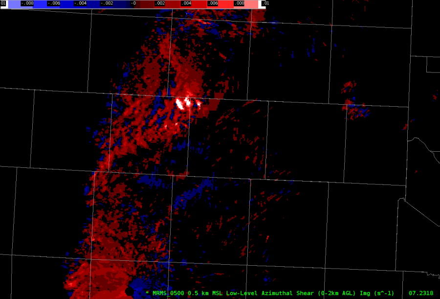
Tornado Warning Prompted with Merged AzShear

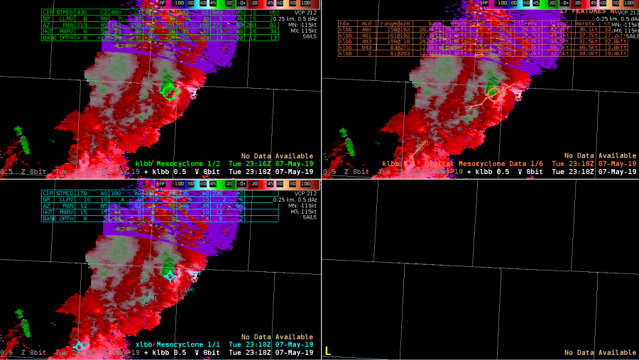
Radar imagery f/ KGRK showed rotational low-level organization within the QLCS. While ProbSevere was putting near 80% for the wind threat with and increase to a 9% for a tornado threat. The Merged AzShear product was showing strong 1D pseudo-vorticity in the area of interest and was used to push the SVR warning w/ Tor possible tag up to a Tornado Warning. Immediately after issuing the warning the circulation seemed to fall apart, however, a couple minutes after the warning a report of a wall cloud with a rope tornado came in through the chat. Lead time may have been nill (also due to not having a Text Workstation up yet), but the warning seemed to have verified thanks to the dependency on the AzShear product. With a single-radar AzShear in operations it would have been possible to increase lead time.

UPDATE:

Going back and looking at the GLM data showed intensification of the cell which spawned the reported tornado before genesis (or at least before the report). GLM FED shows the previously warned cell to the north fading in strength and the intensifying updraft of the cell to the south that prompted a tornado warning.

#ProtectAndDissipate


Even Better Example where Merged AzShear can be more beneficial than Single-Radar AZ Shear

Let’s say your storm’s velocity data crosses into the dreaded “purple haze”. This  loss of velocity data also results in a loss of single-radar Az Shear data. So, what do you do if you’re on the warning desk? Do you scream and panic? No, that wouldn’t be ideal. Rather, take a look at the Merged-shear products. In this example, a strong storm moved into the “purple haze” of KMXX’s radar, thus losing reliable velocity and single-radar AZ Shear data. However, surrounding area radars are still getting a good reading on the storm, and thus the operational forecaster can utilize the Merged Shear products to calm their nerves as to whether the storm is still worthy of maintaining focus on it.


Example where Merged AzShear can be more beneficial than Single-Radar AZ Shear.

What happens if convection moves far enough from your radar to where the single-radar Az Shear becomes less reliable? The Merged shear products can then potentially be useful! In this example, the storms have moved to the edge of the useful range of the KMXX radar. The KMXX single-radar Az Shear (top right) values are much weaker/potentially less reliable and the KMXX velocity data (bottom right) also leads to uncertainty as to how much attention should still be given to the ongoing convection. Utilizing the Merged shear products (left) indicates that the convection is likely still strong (at a minimum) and warrants further investigation.

Single vs. Merged; +/- For Each

Almost an hour into this replay of an archived case and some thoughts on the Single Site AzShear using this image as an example.

I can count at least 8 areas that AzShear shows potential areas of rotation that need a closer look.  Advantage.  The rapid update every volume scan means there isn’t a wait for the 2-minute Merged AzShear products to arrive.  Advantage.  However, there is a lot of noise, especially along the leading edge of the gust front/line of storms to the southwest of the KMMX radar site.  Not shown is the single-radar AzShear from KEOX which is not as noisy but is also looking at the mid-level of the storms.  Disadvantage.  The strength of the AzShear signatures depends on which radar you are looking from and the orientation to the beam.  Disadvantage.  Features are range-dependent so if you are looking for a low-level feature from a distant radar without a radar closer to the area of interest; Disadvantage.

So, how may the Merged AzShear products come into play?  We’ll use this as an example (which is taken from the same time and space as the image above):

The first thing to notice is that there is much less noise; the merged product has a lot of the small +/- AzShear values around the KMXX radar site removed but still holds on to the stronger areas that may need closer inspection.  Advantage.  For the line southwest of KMXX, northwest of KEOX, again, many of the less interesting/noisy features are reduced leaving the areas of stronger shear in for closer inspection.  Advantage.  However, the biggest disadvantage is the time-lag; since the merged AzShear products arrive every 2 minutes, any quickly intensifying areas of rotation can be missed.  The merged product also has trail of where the strongest AzShear values are which can be used for tracking purposes; Netural.

As it stand right now, I’d say that I like the single-radar AzShear for storm interrogation purposes since it arrives nearly real-time with every scan.  It is also useful because it gives me the base information that gets fed into the merged products which then goes into the MRMS Rotation Track.  I’m a big fan of knowing what is going on “behind the curtain” and the single radar AzShear product gives me that information.

-Dusty

Using Single Radar Shear w/ Merged Shear

Here is another example as to where high single-radar Az Shear and Merged shear values remain significantly high while velocity values falsely indicate the storm may be weakening. Using Az Shear coincident with Merged Shear data would result in myself (as an operational forecaster) maintaining focus on what is likely still a significant storm, even though the overall velocity data no longer looked as impressive.

Neighboring Radar’s Az Shear Useful for Situational Awareness

When initially switching Az Shear from KMXX to KEOX, I was surprised as to how strong the Az Shear values were from KEOX well before they increased from KMXX. This got me thinking as to how Az Shear could be used in a situational awareness type of setup.

Given that the storm was >100km from the KEOX radar site, the higher beam height from KEOX was likely picking up on what was going on in the mid levels of the storm (although the beam width was also much greater). A good situational awareness “best practice” could be to have a procedure or display that would display all the single radar Az Shear values  from both the home and surrounding radar sites into a multi-panel display. Noticing that a particular radar was showing higher Az Shear values could lead the operational forecaster to focus more attention on a particular storm, with the idea of the earlier increase in Az Shear potentially leading to a faster lead time down the road.

KEOX single radar AZ Shear is on the left. KMXX single radar AZ Shear is top right, and KMXX velocity data on bottom right.

Single Radar AzShear vs Merged

Single radar AZ Shear would be very beneficial to the field offices. While the merged Az Shear is useful in assisting with various trends (per se) and overall placement of stronger values, having the single radar data provides the fastest information to the forecaster with the best resolution. During a real-time situation, having instant data rather than data that is ~2 to 3 min old can make a significant difference.

This image shows the single radar AZ Shear data on the left, with the merged 0-2km on the bottom right, and merged 3-6km on the top right. The place marker in each image shows where the “area of warning interest” is currently located.

Warning off AZ Shear?

In this example, I would  feel quasi-comfortable issuing a tornado warning before a tight couplet appears on velocity, given the increased Az Shear values that occur about a volume scan before the low level velocity tightens up. The caveat is that the forecaster must fully know the atmospheric setup before focusing purely on Az Shear data.

These images indicate, from top to bottom, the initial enhancement from Az Shear before the velocity couplet really started to tighten up. The following two images are the two subsequent scans.